(via TheNewswire)
Results from the second 2026 core hole continue to reinforce the significance of mapped high-angle structures as controls on gold mineralization at the SSD Target
Gold mineralization is open in all directions, especially down-dip into promising structural and stratigraphic settings that have never been drill-tested
T2601 and T2602 confirmed the presence of a lamprophyre-filled fault corridor; igneous rocks are noteworthy for their association with gold mineralization in Carlin-type gold systems
Vancouver, British Columbia, August 25, 2026 – TheNewswire - Westward Gold Inc. (CSE: WG, OTCQB: WGLIF, FSE: IM50) (“Westward” or the “Company” ) is pleased to announce assay results for the second core hole completed at the SSD Target (“SSD” ), Toiyabe Hills Property, Lander County, NV (“Toiyabe Hills” , or the “Property” ). T2601 and T2602 – drilled to total depths of 123 and 116 metres, respectively – were designed to 1) characterize the host rocks, hydrothermal alteration, and structure associated with gold mineralization at SSD, 2) verify the continuity of these features from their surface expression downward into the third dimension, 3) build upon the data gleaned from nearby trenching to further determine controls on gold mineralization (see Westward press release dated August 4, 2026) , 4) apply these controls as a vector for upcoming deeper drilling and a tool for additional near-term SSD target development, and 5) modernize and upgrade previously-unconfirmed legacy data from the near-surface environment at SSD.
Key Takeaways:
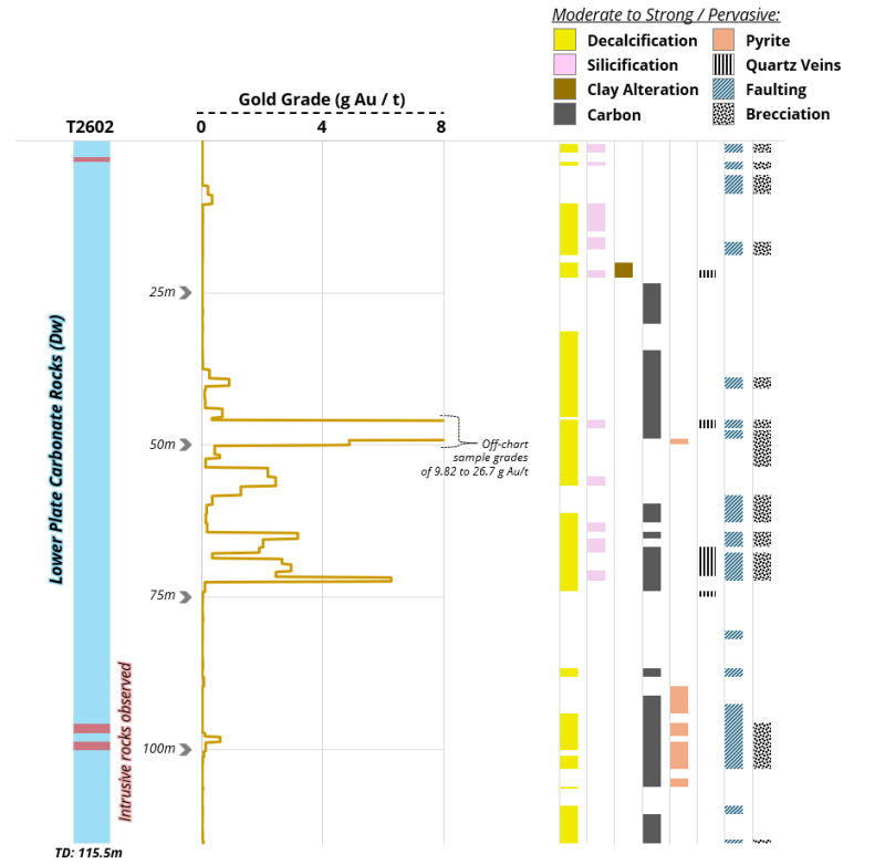
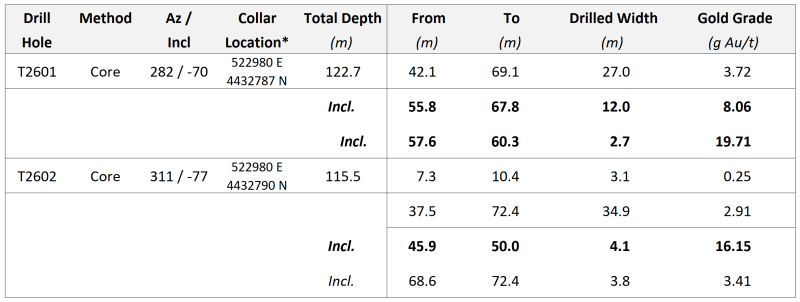
T2602 intersected 34.9 metres of 2.91 g Au/t, including 4.1 metres of 16.15 g Au/t in silty limestone of the Wenban Formation; this broad zone of gold mineralization is characterized by pervasive decalcification, variable silicification, carbon, pyrite, variable clay alteration, and breccia associated with high-angle faults and penetrative shearing (see Figures 1 through 4 below).
T2601 and T2602 have verified the presence of a lamprophyre-filled fault corridor, building upon prior observations of lamprophyre and quartz porphyry sills and dikes in and around the greater SSD Target area; these specific igneous rocks support the likelihood of a robust Carlin-type gold system on the Property.
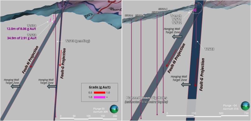
The gold intercepts in T2602 have reinforced the modeling of Fault-N and Fault-G as important controlling structures (originally identified through trenching and followed up on in hole T2601), with their hanging-wall zones demonstrating significant gold grades (see Figure 6 below).
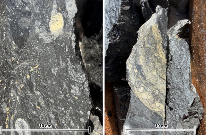
T2602 marks the first occurrence of orpiment logged in drill core to date – this bright yellow arsenic sulfide mineral typically forms as late-stage vein / fracture filling in Carlin-type systems, and is a key pathfinder mineral in early-stage gold exploration (see Figure 5 below).
Elevated arsenic and antimony are associated with gold mineralization, providing further confirmation of a Carlin-type gold system.
Figure 1 – T2602: Stratigraphy, Gold Grades, and Detailed Logging
Click Image To View Full Size
Figure 2 – SSD Target: 2026 Assay Results
Click Image To View Full Size
*UTM NAD83 Zone 11 Metres; Elevations: 2,309.2 m (T2601), 2,309.2 m (T2602).
Note: Gold intervals were calculated based on a 0.14 g Au/t cutoff grade. All gold intervals are presented as drill hole lengths; true thicknesses of mineralization are currently unknown and estimated at 50-70% of reported thicknesses. T2601 assay results were published on August 18, 2026. Refer to QA/QC statement below for additional details.
Mr. Steven Koehler, Westward’s Lead Technical Advisor, commented: “Relentless attention to detail – as I’m often reminded of by colleagues – is what ultimately drives success in Carlin-type gold exploration, and past discoveries have much to teach us in this regard. The data we’ve accumulated thus far at SSD (both legacy and current), and the exploration path it’s now leading us down, reminds me of a mid-1990’s program I led in the Carlin North region. The geological setting of these two areas is strikingly similar: near-surface gold mineralization in tandem with a zone of deeper, disseminated gold identified via sparse RC drilling. In the Carlin North example, initial trenching identified a 20-metre-wide gold-bearing fault cutting upper-plate rocks. As we continued to follow this structure down-dip, we drilled into a contiguous zone of upper-plate-hosted gold mineralization which evolved into the Crow Deposit. Deeper, framework-style drilling into favourable lower-plate carbonate rocks – along and adjacent to the fault – eventually resulted in the discovery and delineation of what is now the Pete Bajo underground mine.”
Mr. Koehler continued: “Geological themes and patterns tend to repeat in northern Nevada, and the many first-hand discovery lessons the technical team and I bring to the table will be invaluable as we advance SSD. T2602 has further confirmed that the SSD Target is a compelling opportunity, and we intend to aggressively explore the area with additional trenching, mapping, sampling and deeper drilling as near-term priorities.”
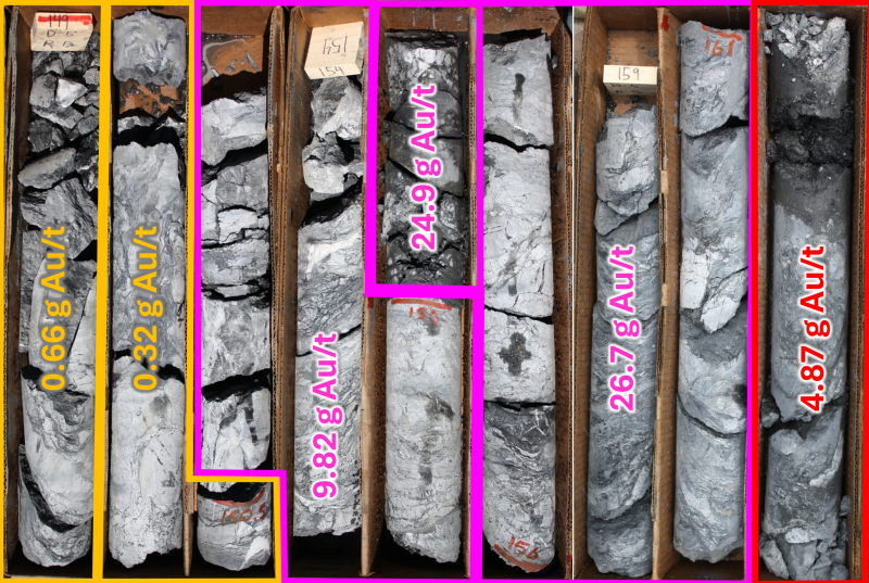
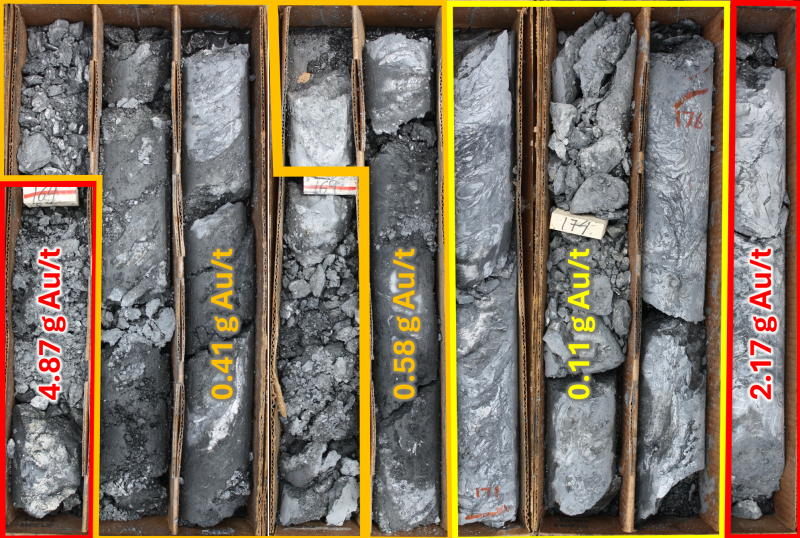
Figures 3 and 4 below display portions of the PQ-sized core that returned significant gold grades. The gold is predominantly hosted in silty limestone of the Devonian Wenban Formation, and the highest-grade samples are characterized by pervasive decalcification, secondary carbon flooding, elevated sooty pyrite, and breccia associated with penetrative shearing. Figure 5 below shows examples of logged orpiment in core, a significant pathfinder mineral in Carlin-type gold exploration; orpiment – similarly to realgar (both arsenic sulfide minerals) – commonly signals low-temperature hydrothermal activity linked to Carlin-style gold deposition.
Figure 3 – T2602 Select Core Photos (45.1 m – 49.7 m Depth)
Click Image To View Full Size
Figure 4 – T2602 Select Core Photos (49.7 m – 54.3 m Depth)
Click Image To View Full Size
Figure 5 – SSD Target: Examples of Orpiment Logged in T2602
Click Image To View Full Size
Note: Image on left from a depth of 88.7 metres, image on right from a depth of 90.1 metres.
SSD Target – Next Steps:
Gold mineralization encountered in T2601 and T2602 is open in all directions, most notably down-dip along controlling faults and into structural and stratigraphic settings that have never been tested. High-priority areas for upcoming drilling represent high-value targets in Nevada’s most favourable gold host rocks of the Wenban and underlying Roberts Mountains Formations.
Westward’s existing Plan of Operations with the U.S. Bureau of Land Management (“BLM” ) over the SSD area is a significant strategic advantage, reducing permitting risk and enabling the Company to expand the scope of ground disturbance to accommodate additional roads, pads, and trenches in a timely manner. The season’s first reverse-circulation (“RC” ) drill hole at SSD (T2603), was recently completed to a total depth of 396.2 metres, with the primary goal of testing the hanging-wall of Fault-G. Four deep RC holes are now planned to test down-dip extensions of gold mineralization in the hanging-wall of Fault-N (see Figure 6 below), along with additional step-out framework holes to the north and northeast; mapping, surface geochemistry, and geophysical surveys suggest the system may strengthen in these directions.
Figure 6 – SSD Target: Controlling Structures & Upcoming Drilling (Section View)
Click Image To View Full Size
Note: Section view looking northwest; 309-degree azimuth (LHS) and 316-degree azimuth (RHS), grades included on drill traces only shown if >0.5 g Au/t.
Hole details (all coordinates UTM NAD83 Zone 11 Metres):
T2601: Easting 522980, Northing 4432787, Elevation 2309.2, Azimuth 282, Inclination -70;
T2602: Easting 522980, Northing 4432790, Elevation 2309.2, Azimuth 311, Inclination -77;
T2603: Easting 522981.5, Northing 4432796.6, Elevation 2309.2, Azimuth 000, Inclination -90, TD 396.2 m;
SSD26-J: Easting 522245.1, Northing 4432710, Elevation 2190.6, Azimuth 000, Inclination -90, Estimated TD 914.4 m;
SSD26-K: Easting 522620, Northing 4432739, Elevation 2239.8, Azimuth 000, Inclination -90, Estimated TD 914.4 m;
SSD26-L: Easting 522721, Northing 4432552, Elevation 2205.1, Azimuth 000, Inclination -90, Estimated TD 914.4 m;
SSD26-M: Easting 522611, Northing 4432454, Elevation 2170.6, Azimuth 000, Inclination -90, Estimated TD 914.4 m.
Quality Assurance / Quality Control (“QA/QC”)
The Company implemented a best-practices QA/QC program during the drilling of core hole T2602. Drilling consisted of PQ-sized core from the collar to a total depth of 115.5 metres. All sampling was conducted under the supervision of the Company’s Vice President Exploration and/or members of its technical team, and the chain of custody from the Property to the sample preparation facility was continuously monitored. Samples were transported directly from the field to Modern Land and Development in Carlin, NV, where the individual sample intervals were cut in half and bagged for delivery.
Core samples were delivered to ALS Limited’s (“ALS” ) preparation facility located in Elko, NV. Samples were dried at 100 degrees Celsius, crushed to 70% passing -2mm, Boyd rotary split off 250g, which was then pulverized to greater than 85% passing 75 microns. The resulting sample pulps were delivered to ALS’ laboratories at either 4977 Energy Way, Reno, NV, 89502 or 2103 Dollarton Hwy, North Vancouver, BC, V7H 0A7 for fire assay and multi-element assays.
Individual core samples for fire assay were selected at intervals ranging from 0.3m to 1.7m. Overall QA/QC frequency was set at a minimum of 15%, including standards, blanks, and three varieties of duplicates. Standards and blanks were sourced from Rocklabs of Aukland, New Zealand. Data verification of the analytical results included a statistical analysis of the standards, blanks and duplicates that must fall within specified ranges for acceptance. All standards, blanks and duplicates were checked and verified and are within these ranges. All core samples were analyzed for gold and 49 additional elements. Assays consisted of fire assay (Au-AA23) for gold on each individual sample. For multi-element geochemistry, composited intervals ranging between 5.8 metres to 7.8 metres were analyzed with four-acid analysis (ME-MS61m). Over-limit gold assays were determined using fire assay with a gravimetric finish (Au-GRA21) on a 30-gram split.
The significant gold zones were calculated using a weighted average of interval lengths and a cut-off grade of 0.14 g Au/t was employed, however internal dilution may include up to 6.7 metres of material below the cut-off. Drill-hole deviation for T2602 was measured by a gyroscopic down-hole survey completed by IDS of Elko, NV. The survey provides accurate down hole inclination and azimuth of the hole. Obtaining an accurate survey of the drill hole leads to a better contextual understanding of the core samples, and a more robust 3D geological model All gold intervals are presented as drill hole lengths; true thicknesses of mineralization are currently unknown and estimated at 50-70% of reported thicknesses. Refer to Westward Gold’s press release dated August 18, 2026, for additional T2601-specific QA/QC disclosure.
Qualified Person
The technical information contained in this news release was reviewed and approved by Robert Edie, Vice President Exploration of the Company, who is a Qualified Person under National Instrument 43-101 – Standards of Disclosure for Mineral Projects. Mr. Edie is a Certified Professional Geologist (CPG) through the American Institute of Professional Geologists (AIPG).
About Westward Gold
Westward Gold is a mineral exploration company focused on developing the Toiyabe Hills Project located in the Cortez Trend area of Lander County, Nevada, and the Coyote and Rossi Projects located along the Carlin Trend in Elko County, Nevada. From time to time, the Company may also evaluate the acquisition of other mineral exploration assets and opportunities.
For further information contact:
Andrew Nelson
Chief Financial Officer
Westward Gold Inc.
+1 (604) 828-7027
andrew@westwardgold.com
www.westwardgold.com
The Canadian Securities Exchange has neither approved nor disapproved the contents of this news release. The Canadian Securities Exchange does not accept responsibility for the adequacy or accuracy of this news release.
This news release contains or incorporates by reference “forward-looking statements” and “forward-looking information” as defined under applicable Canadian securities legislation. All statements, other than statements of historical fact, which address events, results, outcomes, or developments that the Company expects to occur are, or may be deemed, to be, forward-looking statements. Forward-looking statements are generally, but not always, identified by the use of forward-looking terminology such as "expect", "believe", "anticipate", "intend", "estimate”, “potential”, “on track”, “forecast", "budget", “target”, “outlook”, “continue”, “plan” or variations of such words and phrases and similar expressions or statements that certain actions, events or results “may”, “could”, “would”, “might” or “will” be taken, occur or be achieved or the negative connotation of such terms.
Such statements include, but may not be limited to, information as to strategy, plans or future financial or operating performance, such as the Company’s expansion plans, project timelines, expected drilling targets, and other statements that express management’s expectations or estimates of future plans and performance.
Forward-looking statements or information are subject to a variety of known and unknown risks, uncertainties and other factors that could cause actual events or results to differ from those reflected in the forward-looking statements or information, including, without limitation, the need for additional capital by the Company through financings, and the risk that such funds may not be raised; the speculative nature of exploration and the stages of the Company’s properties; the effect of changes in commodity prices; regulatory risks that development of the Company’s material properties will not be acceptable for social, environmental or other reasons, availability of equipment (including drills) and personnel to carry out work programs, that each stage of work will be completed within expected time frames, that current geological models and interpretations prove correct, the results of ongoing work programs may lead to a change of exploration priorities, and the efforts and abilities of the senior management team. This list is not exhaustive of the factors that may affect any of the Company’s forward-looking statements or information. These and other factors may cause the Company to change its exploration and work programs, not proceed with work programs, or change the timing or order of planned work programs. Additional risk factors and details with respect to risk factors that may affect the Company’s ability to achieve the expectations set forth in the forward-looking statements contained in this news release are set out in the Company’s latest management discussion and analysis under “Risks and Uncertainties”, which is available under the Company’s SEDAR+ profile at www.sedarplus.ca. Although the Company has attempted to identify important factors that could cause actual results to differ materially, there may be other factors that cause results not to be as anticipated, estimated, described or intended. Accordingly, readers should not place undue reliance on forward-looking statements or information. The Company’s forward-looking statements and information are based on the assumptions, beliefs, expectations, and opinions of management as of the date of this press release, and other than as required by applicable securities laws, the Company does not assume any obligation to update forward-looking statements and information if circumstances or management’s assumptions, beliefs, expectations or opinions should change, or changes in any other events affecting such statements or information.

Copyright (c) 2026 TheNewswire - All rights reserved.
© 2026 Canjex Publishing Ltd. All rights reserved.