Tamarack, Minnesota--(Newsfile Corp. - September 9, 2026) - Talon Metals Corp. (TSX: TLO) (OTC: TLOFF) ("Talon" or the "Company") today announced assay results from the previously reported record 46.43-meter interval of Massive Sulphide Unit ("MSU") and Mixed Massive Sulphide Unit ("MMS") mineralization in drill hole 25TK0562A at the Tamarack Nickel-Copper-Cobalt Project ("Tamarack Project"), located in central Minnesota.
Highlights
Selected assay highlights are summarized below and in Tables 1 and 2, with drill hole collar information provided in Table 3 and individual sample assay results and downhole depths provided in Table 4.
Drill hole 25TK0562A returned 46.43 meters grading 13.37% Ni, 16.54% Cu, 0.10% Co, 7.85 g/t Pd, 14.49 g/t Pt and 8.56 g/t Au (27.39% NiEq or 54.78% CuEq) starting at 752.97 meters (see Figure 1 and Table 1).
The interval includes 26.22 meters grading 14.95% Ni, 17.85% Cu, 0.11% Co, 8.53 g/t Pd, 16.79 g/t Pt, and 9.13 g/t Au (30.20% NiEq or 60.41% CuEq) starting at 758.00 meters (see Table 1).
The 46.43-meter interval is the longest combined MSU and MMS intercept reported to date at the Tamarack Project.
Drill hole 25TK0562A is located approximately 50 meters southwest of Vault Zone discovery hole 25TK0563 and was drilled to test the continuation of mineralization associated with a borehole electromagnetic ("BHEM") anomaly identified from drill hole 25TK0566A (see Figure 2).
The results provide further support for Talon's geological interpretation of the Vault Zone and its BHEM-guided exploration approach.
Table 1: Select Assay Intervals for Drill Hole 25TK0562A
Drill Hole
# | From
(m) | To
(m) | Length
(m) | Assay |
| NiEq
(%) | CuEq
(%) |
Ni
(%) | Cu
(%) | Co
(%) | Pd
(g/t) | Pt
(g/t) | Au
(g/t) | Ag
(g/t) |
| 25TK0562A | 752.97 | 799.40 | 46.43 | 13.37 | 16.54 | 0.10 | 7.85 | 14.49 | 8.56 | 31.51 | 27.39 | 54.78 |
| including | 758.00 | 784.22 | 26.22 | 14.95 | 17.85 | 0.11 | 8.53 | 16.79 | 9.13 | 22.55 | 30.20 | 60.41 |
| Please refer to Table 4 for further information. |
"When we named the Vault Zone, we didn't realize quite how appropriate that name might become," said Brian Goldner, Chief Exploration Officer for Talon Metals. "Any one of these grades will get your attention, but to see nickel, copper, cobalt, platinum, palladium, and gold all concentrated at these levels in the same rock is particularly significant and one of the many reasons polymetallic deposits like Tamarack are so exciting. Given the significance of this intercept, we wanted to publish the individual assay results for every sample across the interval and let the numbers speak for themselves."
"The continued results from the Vault Zone demonstrate the progress our exploration team is making as it systematically tests this mineralized system," said Darby Stacey, CEO of Talon Metals. "Beyond the grades themselves, the step-out distance must be highlighted and underscores the potential strategic importance of Tamarack as a future domestic source of critical minerals. To say it's exciting is an understatement, and we remain focused on exploring and testing hypotheses to understand the full potential of the Vault Zone."
Record Intercept in Drill Hole 25TK0562A
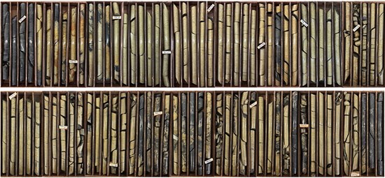
Figure 1: Drill core from drill hole 25TK0562A at 752.97 meters depth showing an interval of 46.43 meters of MSU and MMS.
To view an enhanced version of this graphic, please visit:
https://images.newsfilecorp.com/files/2443/313725_765d4b6f94d219ac_001full.jpg
As previously announced on August 6, 2026, drill hole 25TK0562A intercepted a record 46.43 meters of MSU and MMS beginning at 752.97 meters. Assay results have now returned grades of 13.37% Ni, 16.54% Cu, 0.10% Co, 7.85 g/t Pd, 14.49 g/t Pt, and 8.56 g/t Au (27.39% NiEq or 54.78% CuEq) over the 46.43-meter interval (see Table 1).
Below the 46.43-meter MSU and MMS interval is 4.60 meters of disseminated chalcocite in the footwall metasediments that also carries significant platinum group element (“PGE”) mineralization and returned a grade of 0.38% Ni, 1.26% Cu, 0.01% Co, 1.87 g/t Pd, 8.90 g/t Pt, and 3.62 g/t Au (5.06% NiEq or 7.80% CuEq) (see Table 2). Additional sampling is planned to determine whether the PGE mineralization continues beyond what has been sampled to date.
Drill hole 25TK0562A was drilled from parent hole 25TK0562 to test a BHEM anomaly identified from drill hole 25TK0566A. Since the Vault Zone discovery, Talon has used BHEM surveys and directional drilling to test the continuity and potential expansion of the mineralized system. The BHEM anomalies shown in Figure 2 are used to help identify and prioritize potential massive sulphide targets. Drill hole 25TK0562A is located approximately 50 meters southwest of Vault Zone discovery hole 25TK0563 and extends known mineralization on the 778-meter level.
The assay results provide additional information on the grade and distribution of mineralization within this portion of the Vault Zone as Talon continues step-out drilling laterally and at depth.
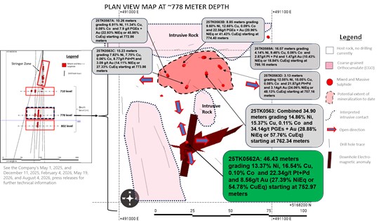
Figure 2: Plan view map of the Vault Zone at the 778-meter level showing the location of drill hole 25TK0562A with respect to other mineralized intercepts and the BHEM anomalies identified in BHEM surveys in 25TK0562A.
To view an enhanced version of this graphic, please visit:
https://images.newsfilecorp.com/files/2443/313725_765d4b6f94d219ac_002full.jpg
Table 2: Summary of Assays for the Broader Mineralized Interval
Drill Hole
# | From
(m) | To
(m) | Length
(m) | Assay | NiEq
(%) | CuEq
(%) |
Ni
(%) | Cu
(%) | Co
(%) | Pd
(g/t) | Pt
(g/t) | Au
(g/t) | Ag
(g/t) |
| 25TK0562A | 752.97 | 804.00 | 51.03 | 12.20 | 15.16 | 0.10 | 7.31 | 13.99 | 8.11 | 31.87 | 25.25 | 50.50 |
| including | 752.97 | 799.40 | 46.43 | 13.37 | 16.54 | 0.10 | 7.85 | 14.49 | 8.56 | 31.51 | 27.39 | 54.78 |
| and | 799.40 | 804.00 | 4.60 | 0.38 | 1.26 | 0.01 | 1.87 | 8.90 | 3.62 | 35.50 | 5.06 | 7.80 |
| Please refer to Table 4 for further information. |
Building on the Vault Zone Discovery
The Vault Zone was established in May 2025 following drilling below the Tamarack Resource Area. Discovery drill hole 25TK0563 intercepted two intervals of MSU and MMS beginning at 762.34 meters and 795.16 meters, for a cumulative 34.9 meters grading 14.86% Ni, 15.37% Cu, 0.11% Co, 24.96 g/t Pt+Pd and 9.18 g/t Au (28.88% NiEq or 57.76% CuEq) (see Figure 2).
Talon continues to evaluate drilling, assay results, and geophysical data together as work advances at the Vault Zone.
Quality Assurance, Quality Control, and Qualified Persons
The Talon sample preparation, security, and Quality Assurance ("QA") / Quality Control ("QC") protocols for the Tamarack Nickel-Copper-Cobalt Project are consistent with industry best practices and Canadian Institute of Mining, Metallurgy and Petroleum Mineral Exploration Best Practice Guidelines (November 2018).
Talon has implemented documented QA programs that incorporate written procedures, acceptable industry software, database organization, and standardized data presentation, all of which contribute to confidence in the integrity of the dataset. The QC protocol has been documented (see also the November 2022 Technical Report) and consistently applied since Talon's involvement with the Tamarack Nickel-Copper-Cobalt Project.
The QA/QC program is based on the systematic insertion of certified reference materials ("CRM"), including a variety of standards, blanks (materials containing no economic minerals), and duplicate samples, which are used to monitor contamination, precision, and analytical accuracy at the primary assay laboratory and to prevent inaccurate data from being accepted into the assay database. Samples are submitted in batches of approximately 250 samples. Within each batch, QA/QC materials are inserted at a rate of approximately one QA/QC sample for every 10 core samples, including CRM standards inserted at the front end of massive sulphide mineralization, blanks inserted immediately following massive sulphide mineralization, and duplicate samples inserted approximately every 10 samples.
Sample security and chain-of-custody procedures are maintained throughout the sampling and analytical process. Core samples are prepared and stored in a secure facility prior to shipment. Samples are placed into plastic bins or sealed totes, which are secured using tamper-evident security tags. Before sealing, a chain-of-custody form is placed inside each container. The containers are transported from the core facility to the ALS laboratory in Thunder Bay, Ontario for preparation, and are subsequently shipped to ALS Laboratories in Vancouver, British Columbia for analysis, where the chain-of-custody documentation is signed by laboratory personnel and returned to Talon upon receipt, confirming sample integrity.
Please see the technical report entitled "November 2022 National Instrument 43-101 Technical Report of the Tamarack North Project - Tamarack, Minnesota" with an effective date of November 2, 2022 ("November 2022 Technical Report") prepared by independent "Qualified Persons" (as that term is defined in National Instrument 43-101 ("NI 43-101")) Brian Thomas (P. Geo), Roger Jackson (P. Geo), Oliver Peters (P. Eng) and Christine Pint (P.G) for further information on the QA/QC, data verification, analytical and testing procedures at the Tamarack Nickel-Copper-Cobalt Project. The November 2022 Technical Report is available on the Company's website (www.talonmetals.com) or on SEDAR at (www.sedarplus.ca). The laboratory used is ALS Minerals, which is independent of the Company.
Lengths are drill intersections and not necessarily true widths. True widths cannot be consistently calculated for comparison purposes between holes because of the irregular shapes of the mineralized zones. Drill intersections have been independently selected by Talon. Drill composites have been independently calculated by Talon. The geological interpretations in this news release are solely those of the Company. The locations and distances highlighted on all maps in this news release are approximate.
Dr. Etienne Dinel, Project VP Geology at Talon, is a Qualified Person within the meaning of NI 43-101. Dr. Dinel is satisfied that the analytical and testing procedures used are standard industry operating procedures and methodologies, and he has reviewed, approved, and verified the technical information disclosed in this news release, including sampling, analytical, and test data underlying the technical information.
Where used in this news release:
NiEq% = Ni% + Cu% x $4.00/$8.00 x Cu Recovery/Ni Recovery + Co% x $20.00/$8.00 x Co Recovery/Ni Recovery + Pt [g/t]/31.103 x $1,000/$8.00/22.04 x Pt Recovery/Ni Recovery + Pd [g/t]/31.103 x $1,000/$8.00/22.04 x Pd Recovery/Ni Recovery + Au [g/t]/31.103 x $2,000/$8.00/22.04 x Au Recovery/Ni Recovery + Ag [g/t]/31.103 x $20.00/$8.00/22.04 x Ag Recovery/Ni Recovery
CuEq% = Cu% + Ni% x $8.00/$4.00 x Ni Recovery/Cu Recovery + Co% x $20.00/$4.00 x Co Recovery/Cu Recovery + Pt [g/t]/31.103 x $1,000/$4.00/22.04 x Pt Recovery/Cu Recovery + Pd [g/t]/31.103 x $1,000/$4.00/22.04 x Pd Recovery/Cu Recovery + Au [g/t]/31.103 x $2,000/$4.00/22.04 x Au Recovery/Cu Recovery + Ag [g/t]/31.103 x $20.00/$4.00/22.04 x Ag Recovery/Cu Recovery
For Ni and Cu recoveries, please refer to the formulae in the November 2022 Technical Report. Recovery of Ni to the Cu concentrate was excluded from the NiEq calculation. The following recoveries were used for the other metals: 64.1% for Co, 82.5% for Pt, 69.3% for Pd, and 72.6% for Au and Ag.
About Talon
Talon is a TSX-listed base metals company advancing and operating high-grade nickel-copper assets in the United States, including 100% ownership of the Eagle Mine and Humboldt Mill in Michigan, the only primary nickel mine currently operating in the United States, and the Tamarack Nickel-Copper-Cobalt Project in Minnesota. Talon is in a joint venture with Rio Tinto on the high-grade Tamarack Nickel-Copper-Cobalt Project located in central Minnesota. Talon's shares are also traded in the US over the OTC market under the symbol TLOFF. The Tamarack Nickel-Copper-Cobalt Project comprises a large land position (18 km of strike length) with additional high-grade intercepts outside the current resource area. Talon has an earn-in right to acquire up to 60% of the Tamarack Nickel-Copper-Cobalt Project and currently owns 51%. Talon has a neutrality and workforce development agreement in place with the United Steelworkers union. Talon's Beulah Mineral Processing Facility in Mercer County was selected by the US Department of Energy for a US$114.8 million funding grant from the Infrastructure Investment and Jobs Act, and the US Department of War awarded Talon a grant of US$20.6 million to support and accelerate Talon's exploration efforts in both Minnesota and Michigan. Talon has well-qualified and experienced exploration, mine permitting, mine development, operations, and community relations teams.
Forward-Looking Statements
This news release contains certain "forward-looking statements". All statements, other than statements of historical fact that address activities, events or developments that the Company believes, expects or anticipates will or may occur in the future, are forward-looking statements. These forward-looking statements reflect the current expectations or beliefs of the Company based on information currently available to the Company. Such forward-looking statements include statements relating to future exploration work, including future drill results and assays as well as geological interpretations. Forward-looking statements are subject to significant risks and uncertainties and other factors that could cause the actual results to differ materially from those discussed in the forward-looking statements, and even if such actual results are realized or substantially realized, there can be no assurance that they will have the expected consequences to, or effects on, the Company.
Any forward-looking statement speaks only as of the date on which it is made and, except as may be required by applicable securities laws, the Company disclaims any intent or obligation to update any forward-looking statement, whether as a result of new information, future events or results or otherwise. Although the Company believes that the assumptions inherent in the forward-looking statements are reasonable, forward-looking statements are not guarantees of future performance and accordingly undue reliance should not be put on such statements due to the inherent uncertainty therein.
Table 3: Collar Locations
Drill Hole
(#) | Easting
(m) | Northing
(m) | Elevation
(masl) | Azm | Dip | End Depth
(m) |
| 25TK0562A | 490998.75 | 5168292.21 | 388.33 | 109.43 | -85.15 | 886.35 |
Collar coordinates are UTM Zone 15N, NAD83.
Azimuths and dips are taken from the survey record at collar unless otherwise noted. |
Table 4: Individual Sample Assay Table
Drill Hole
# | From
(m) | To
(m) | Length
(m) | Assay | NiEq
(%) | CuEq
(%) |
Ni
(%) | Cu
(%) | Co
(%) | Pd
(g/t) | Pt
(g/t) | Au
(g/t) | Ag
(g/t) |
| 25TK0562A | 752.97 | 754.43 | 1.46 | 10.70 | 20.40 | 0.15 | 2.46 | 0.24 | 0.70 | 10.00 | 21.70 | 43.40 |
| 754.43 | 755.80 | 1.37 | 7.52 | 20.60 | 0.10 | 2.28 | 2.17 | 0.52 | 15.00 | 19.29 | 36.91 |
| 755.80 | 757.25 | 1.45 | 14.70 | 16.35 | 0.14 | 4.34 | 1.24 | 1.96 | 12.00 | 24.40 | 48.80 |
| 757.25 | 758.00 | 0.75 | 4.67 | 16.90 | 0.05 | 5.11 | 3.76 | 15.45 | 40.10 | 20.02 | 36.50 |
| 758.00 | 759.50 | 1.50 | 13.15 | 19.85 | 0.12 | 6.03 | 10.15 | 11.50 | 18.10 | 28.70 | 57.41 |
| 759.50 | 761.00 | 1.50 | 14.75 | 18.20 | 0.12 | 6.29 | 11.80 | 14.25 | 19.30 | 30.50 | 61.00 |
| 761.00 | 762.50 | 1.50 | 15.35 | 17.85 | 0.11 | 8.12 | 14.95 | 12.15 | 65.20 | 31.19 | 62.38 |
| 762.50 | 764.00 | 1.50 | 16.75 | 16.60 | 0.12 | 8.49 | 16.80 | 17.35 | 28.30 | 33.59 | 67.18 |
| 764.00 | 765.50 | 1.50 | 17.00 | 16.40 | 0.12 | 9.38 | 22.70 | 20.10 | 19.80 | 35.46 | 70.93 |
| 765.50 | 767.00 | 1.50 | 16.00 | 16.45 | 0.11 | 8.03 | 21.20 | 10.70 | 23.30 | 31.58 | 63.16 |
| 767.00 | 768.35 | 1.35 | 15.50 | 18.75 | 0.11 | 6.32 | 18.60 | 2.53 | 9.40 | 29.39 | 58.79 |
| 768.35 | 768.84 | 0.49 | 1.57 | 5.68 | 0.01 | 21.50 | 9.71 | 89.70 | 168.00 | 38.32 | 67.76 |
| 768.84 | 769.50 | 0.66 | 13.40 | 20.60 | 0.11 | 5.36 | 8.58 | 0.05 | 9.20 | 25.90 | 51.79 |
| 769.50 | 771.00 | 1.50 | 13.90 | 19.90 | 0.11 | 4.94 | 8.10 | 0.02 | 9.70 | 25.92 | 51.84 |
| 771.00 | 772.50 | 1.50 | 14.20 | 19.25 | 0.11 | 5.47 | 13.15 | 0.03 | 13.40 | 26.74 | 53.48 |
| 772.50 | 774.00 | 1.50 | 15.65 | 17.60 | 0.12 | 6.90 | 17.75 | 0.05 | 17.40 | 28.27 | 56.55 |
| 774.00 | 775.50 | 1.50 | 15.65 | 17.50 | 0.12 | 6.44 | 13.25 | 0.20 | 14.80 | 27.52 | 55.03 |
| 775.50 | 777.00 | 1.50 | 16.10 | 17.30 | 0.12 | 7.16 | 12.50 | 7.39 | 18.60 | 29.78 | 59.56 |
| 777.00 | 778.50 | 1.50 | 15.85 | 17.95 | 0.12 | 7.21 | 15.35 | 2.95 | 15.20 | 29.10 | 58.21 |
| 778.50 | 780.00 | 1.50 | 17.10 | 17.30 | 0.13 | 20.00 | 30.40 | 0.11 | 10.90 | 33.19 | 66.38 |
| 780.00 | 780.92 | 0.92 | 18.10 | 15.85 | 0.13 | 25.40 | 30.10 | 1.23 | 12.00 | 34.41 | 68.82 |
| 780.92 | 782.00 | 1.08 | 12.25 | 16.10 | 0.09 | 7.36 | 25.30 | 8.18 | 17.60 | 27.46 | 54.92 |
| 782.00 | 783.50 | 1.50 | 12.65 | 21.10 | 0.09 | 6.82 | 18.85 | 23.20 | 27.40 | 33.36 | 66.73 |
| 783.50 | 784.22 | 0.72 | 14.65 | 20.20 | 0.11 | 3.96 | 12.70 | 2.72 | 11.20 | 28.12 | 56.25 |
| 784.22 | 785.00 | 0.78 | 3.98 | 7.16 | 0.04 | 4.14 | 6.00 | 13.40 | 87.90 | 13.81 | 25.22 |
| 785.00 | 786.37 | 1.37 | 9.04 | 14.30 | 0.07 | 8.97 | 8.06 | 15.65 | 79.70 | 23.37 | 45.79 |
| 786.37 | 787.38 | 1.01 | 11.40 | 14.60 | 0.09 | 6.79 | 12.25 | 4.30 | 38.50 | 22.82 | 45.65 |
| 787.38 | 788.00 | 0.62 | 2.42 | 5.36 | 0.02 | 2.87 | 6.36 | 0.76 | 13.30 | 7.22 | 13.08 |
| 788.00 | 788.85 | 0.85 | 2.62 | 5.34 | 0.02 | 3.36 | 3.58 | 0.70 | 22.20 | 6.99 | 12.72 |
| 788.85 | 790.00 | 1.15 | 13.75 | 16.65 | 0.10 | 10.15 | 15.55 | 6.09 | 28.50 | 27.61 | 55.21 |
| 790.00 | 791.50 | 1.50 | 15.80 | 18.60 | 0.12 | 6.33 | 12.00 | 0.03 | 20.60 | 27.99 | 55.98 |
| 791.50 | 792.30 | 0.80 | 14.75 | 17.80 | 0.11 | 6.00 | 12.30 | 0.50 | 14.20 | 26.63 | 53.26 |
| 792.30 | 793.12 | 0.82 | 14.00 | 19.85 | 0.11 | 4.98 | 12.55 | 7.60 | 35.30 | 28.76 | 57.53 |
| 793.12 | 794.00 | 0.88 | 13.50 | 11.75 | 0.09 | 15.90 | 11.20 | 41.80 | 75.10 | 34.64 | 69.27 |
| 794.00 | 795.12 | 1.12 | 4.70 | 7.34 | 0.04 | 10.00 | 17.40 | 7.70 | 54.80 | 15.46 | 28.54 |
| 795.12 | 796.00 | 0.88 | 16.60 | 17.20 | 0.12 | 6.64 | 24.80 | 0.05 | 16.50 | 30.07 | 60.14 |
| 796.00 | 797.50 | 1.50 | 19.10 | 16.75 | 0.13 | 7.67 | 20.70 | 0.03 | 20.70 | 31.87 | 63.74 |
| 797.50 | 798.76 | 1.26 | 18.65 | 15.60 | 0.13 | 17.70 | 37.00 | 35.00 | 196.00 | 44.42 | 88.84 |
| 798.76 | 799.40 | 0.64 | 1.03 | 2.44 | 0.01 | 2.92 | 7.53 | 2.10 | 33.30 | 4.95 | 9.08 |
| 799.40 | 801.00 | 1.60 | 0.50 | 1.32 | 0.01 | 2.07 | 9.51 | 3.45 | 28.20 | 5.03 | 8.21 |
| 801.00 | 802.50 | 1.50 | 0.45 | 1.79 | 0.01 | 2.36 | 12.05 | 5.15 | 56.40 | 6.71 | 10.60 |
| 802.50 | 804.00 | 1.50 | 0.17 | 0.66 | 0.00 | 1.17 | 5.10 | 2.27 | 22.40 | 3.47 | 4.54 |
Length refers to drill hole length and not true width.
True width is unknown at the time of publication.
All samples were analysed by ALS Minerals. Ni, Cu, Co, and S grades are analyzed by sodium peroxide fusion with ICP-AES finish (ME-ICP81). Pt, Pd, and Au are analyzed by 30 g fire assay, and ICP-AES finish with an analytical range of 0.01-100 ppm (PGM-ICP-27). Ag grades are analyzed by a 50 g aqua regia digestion, and ICP-AES finish with an analytical range of 0.2-100 ppm (AG-ICP41). Sample grades reporting greater than 100 ppm trigger an additional 50 g aqua regia digestion and ICP-AES finish with an analytical range of 1-1500 ppm (AG-OG46). Metal screening is applied to samples indicated by geologists that contain coarse Ag or Au. 1 kg pulp screened to 100 microns. Duplicate 30 or 50 g assay on screen undersize. Assay of entire oversize fraction (Ag-SCR21/24) (Au-SCR21/24). |

To view the source version of this press release, please visit https://www.newsfilecorp.com/release/313725

© 2026 Canjex Publishing Ltd. All rights reserved.