(via TheNewswire)
Mapped Macamic Fault Segments Total Approximately 30 km; Three High-Quality Exploration Blocks Across the Launay Property
TORONTO, ON – TheNewswire – November 20, 2026 – Metalite Resources Inc. ( CSE: METL ) ( OTC: JNCCF ) ( FSE: D680 ) (" Metalite " or the " Company ") is pleased to announce the acquisition of additional mineral claims in Québec’s Launay district, expanding its northwestern exploration footprint along the Macamic Fault. The expansion encompasses 59 new claims and applications 1 covering approximately 3,352 hectares and strengthens the Company’s position in the Macamic-Authier Block, one of three principal gold exploration areas being advanced at Launay.
The expansion follows Metalite’s fall 2026 exploration and ongoing historical-data compilation, which highlighted structural trends, geological contacts and preliminary responses warranting further investigation along the northwestern corridor.
" Our work this fall has given us a clearer basis for expanding Launay and deciding where to focus next ," said Alex Storcheus, Executive Chairman of Metalite. " Macamic-Authier brings together an important stretch of the fault corridor, a historical silver-lead showing and a substantial body of exploration information that we can now examine as an integrated package. Together with the Chauvignet and Lyndhurst blocks, it gives us three distinct areas in which to test our geological ideas and build the next generation of exploration targets. "
Three Blocks, a Shared Geological Framework
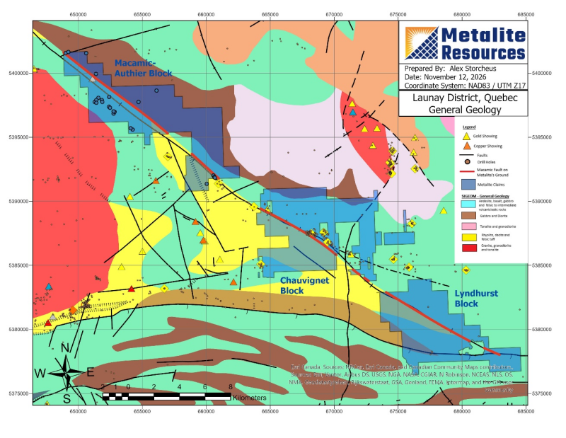
Metalite has organized its Launay exploration activities around three blocks. Their current mapped outlines cover approximately 14,000 hectares in total, with the following areas and principal features:
Chauvignet Block (~5,015 ha) . This central exploration block includes the flagship Trojan Zone, where 105 diamond drill holes have been reported, totalling approximately 21,826 metres. 2 The extensive historical exploration provides a foundation for understanding the gold-exploration setting along the Macamic structural corridor and for evaluating sheared volcanic rocks, intrusive contacts and quartz-vein systems in the district.
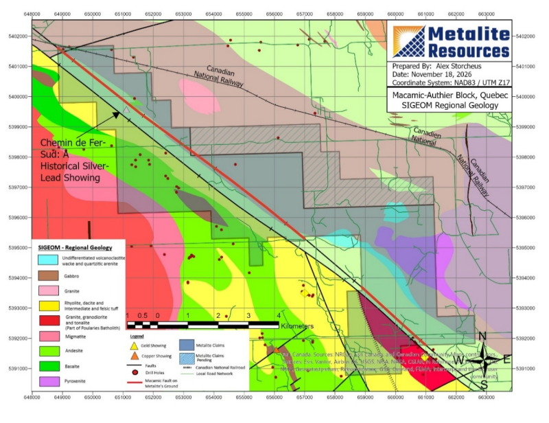
Macamic-Authier Block (~4,978 ha) . The northwestern focus of the current expansion lies in the Macamic–Authier area, extending toward Taschereau. Its attraction combines the Macamic Fault corridor, the historical Chemin de Fer-Sud silver–lead showing , a substantial archive of geological and geophysical work, and practical road and nearby rail access. Parts of the mapped block remain subject to claim-application approval.
Lyndhurst Block (~3,933 ha) . The southeastern block includes the interpreted intersection area of the Lyndhurst and Macamic structural corridors, an important focus for examining how faults, volcanic contacts and alteration relate to one another. The predecessor’s 2021 airborne magnetic and VLF-EM survey covered the Lyndhurst grid, providing data for structural interpretation and follow-up.
Click Image To View Full Size
Metalite’s GIS analysis of the regional SIGÉOM Macamic Fault trace identifies approximately 29.9 kilometres of mapped fault segments (shown in red on the accompanying map) within the three block outlines: ~7.9 km at Chauvignet; ~13.2 km at Macamic-Authier; and ~8.9 km at Lyndhurst. The Launay Property lies in the Abitibi Greenstone Belt, where volcanic rocks, intrusive contacts and major deformation zones provide the geological setting for the Company’s exploration strategy. Numerous historic gold showing have been identified in close proximity and adjacent to the faults and shears in the region, including the Macamic Fault. The Macamic structure is a regional northwest-trending sheared corridor. Historical work at Launay describes quartz–carbonate–tourmaline veining and sulphides in altered, sheared volcanic rocks associated with the fault system and its subsidiary structures. These relationships support investigating deformation, alteration and vein development together, rather than treating individual anomalies in isolation.
As reported on October 28, 2026, Metalite’s integrated program combined satellite imagery, radar, terrain analysis, historical geological information and prospecting, supported by TerraEye’s specialist spectral work. The program identified multiple geological follow-up localities, including potential bedrock exposures, structural and contact relationships, and preliminary spectral responses requiring ground verification.
This work, together with the continuing assessment of historical data, supported the decision to expand along the northwestern continuation of the Macamic structural corridor. The objective is to bring promising geological relationships into a coherent exploration program, with a view to evaluating the potential continuity of mineralization at a district scale.
Macamic-Authier Block: Bringing Historical Reports into a Modern Compilation
Metalite has identified, analysed and digitized 88 historical assessment reports whose mapped coverage overlaps the Macamic-Authier Block. The collection includes a significant body of geophysical information, together with geological mapping and drilling records. Bringing these sources into a common digital framework allows the Company to compare historical responses with mapped structures, mineral occurrences and the current claim configuration. Preliminary findings include:
Drilling. The compilation identifies 24 historical drill holes totalling approximately 3,606 metres directly within the Macamic-Authier Block 3
Chemin de Fer-Sud: A Historical Mineralized Showing . A 1962 report 4 by Québec resident geologist Jean Dugas describes three principal quartz veins in chloritic schist, with pyrite and minor chalcopyrite and galena; tourmaline and carbonate were also observed in one vein. A historical sample from one of the veins was reported to return 0.17 g/t Au, 77 g/t Ag, 0.12% Cu and 1.15% Pb (these historic assay results have not been verified in the field by Metalite professionals).
Road and Rail Access . The block benefits from road access in the Macamic-Authier-Taschereau area, with a railway within a few hundred metres of portions of the property.
Public Land Tenure . Metalite estimates that approximately half of the outlined block overlies public land.
Click Image To View Full Size
Historical logs and survey data are being digitized to identify what has been tested, where coverage is incomplete and which anomalies merit renewed examination. Metalite is also integrating historical geophysical and geochemical data to assess similarities and differences relative to the Trojan Zone and other areas of documented gold mineralization 5 .
Next Steps
Metalite continues to advance its comprehensive compilation and interpretation of historical geological, geophysical and drilling data across the Launay Property, integrating these datasets with the results of its 2026 exploration program to refine and prioritize prospective exploration targets. This ongoing work is being undertaken with a view to finalizing the Company's drill permit applications and advancing its most prospective areas toward drill testing. Metalite has been working closely with its geological and permitting consultants to complete the necessary technical documentation and regulatory submissions, with the objective of positioning the Company to undertake targeted drilling programs, subject to receipt of the required approvals and available funding.
About Metalite Resources Inc.
Metalite Resources Inc. is a Canadian mineral exploration company focused on the acquisition, exploration and advancement of precious-metals projects. The Company owns a 100% interest in the Arthurs Seat Silver-Antimony Project in New South Wales, Australia and a 100% interest in the Launay Gold Property, a district-scale gold project located in Québec's Abitibi Greenstone Belt. The Company's strategy is to create long-term shareholder value through the systematic exploration and advancement of high-potential mineral properties.
Qualified Person
The scientific and technical information contained in this news release has been reviewed and approved by Carey Galeschuk, P.Geo., a "qualified person" as defined in NI 43-101. Mr. Galeschuk is an officer of Metalite and is not independent of the Company.
Contact Information
Metalite Resources Inc.
Chris Hazelton, CEO
(647) 660-8718
info@metaliteresources.com
Forward-Looking Information
This release contains “forward-looking information” within the meaning of applicable Canadian securities laws. Such information is often identified by words including “expect”, “intend”, “plan”, “may”, “will”, “potential” and similar expressions.
Forward-looking information includes expectations regarding the approval and renewal of Launay mineral claims and pending applications; the significance and potential continuity of the Macamic Fault corridor, historical showings, geophysical responses and the Company’s 2026 exploration observations; the accuracy and completeness of historical drilling and geological compilations; the identification and prioritization of exploration targets; the preparation and approval of drill permit applications; and the timing, scope and results of planned fieldwork, geophysical surveys and possible drilling.
These statements are based on management’s current assumptions concerning the accuracy of title, technical and historical data; the availability of financing, personnel and consultants; and the ability to obtain required approvals, permits, land access and suitable operating conditions. Risks include delays or refusal of claim applications, renewals or drilling permits; differences between mapped block outlines and granted claim areas; uncertainty in historical drill-hole, assay, geophysical and geological records; the possibility that mapped faults, historical showings or anomalies will not be confirmed or lead to economic mineralization; environmental, access, consultation, permitting and operational risks; financing constraints; commodity-price fluctuations; and other risks described in the Company’s public filings on SEDAR+.
Actual results may differ materially from those anticipated. There is no assurance that pending titles or permits will be approved or that planned exploration will proceed or produce favourable results. Readers are cautioned not to place undue reliance on forward-looking information, which is made as of the date of this release. The Company undertakes no obligation to update such information except as required by applicable law.
Neither the Canadian Securities Exchange nor its Regulation Services Provider accepts responsibility for the adequacy or accuracy of this release. No stock exchange, securities commission or other regulatory authority has approved or disapproved the information contained herein.
NOT FOR DISTRIBUTION TO UNITED STATES WIRE SERVICES OR DISSEMINATION IN THE UNITED STATES.
1 Includes 19 mineral claim applications that remain subject to review and approval by Québec’s Ministère des Ressources naturelles et des Forêts (MRNF).
2 Based on SIGEOM data compiled by the Company; master dataset accessed in November 2026.
3 Based on SIGEOM data compiled by the Company; master dataset accessed in November 2026
4 https://gq.mines.gouv.qc.ca/documents/EXAMINE/GM13947/GM13947.pdf
5 Launay NI43-101 Technical Report (2023 ), and Y. Labbé (1994), Évolution des failles de la sous-province de l’Abitibi : exemple des discontinuités structurales de Lyndhurst et de Macamic, Québec, doctoral thesis, Université du Québec à Chicoutimi .

Copyright (c) 2026 TheNewswire - All rights reserved.
© 2026 Canjex Publishing Ltd. All rights reserved.