Vancouver, British Columbia--(Newsfile Corp. - October 1, 2026) - Toogood Gold Corp. (TSXV: TGC) (OTCQB: TGGCF) (FSE: D3P) ("Toogood" or the "Company") reports integrated results from ground gravity and drone magnetic surveys, together with initial results from ongoing controlled-source audio-frequency magnetotelluric ("CSAMT") surveying, at its Table Mountain Gold-Silver Project ("Table Mountain" or the "Project") in Lincoln County, Nevada.
"Multiple independent datasets are converging on the same compelling targets at Table Mountain," stated Colin Smith, CEO and Director. "Our gravity and magnetic targets extend over several kilometres and coincide with major faults, intense alteration, widespread epithermal quartz veins and encouraging geochemistry. Initial CSAMT results now add a clearer picture beneath the surface, supporting the interpretation that these structures extend to depth. This convergence gives us a clear focus for our maiden drill program, with multiple priority targets and encouraging depth potential beyond the shallow zones we plan to test first."
Highlights
- Multiple geophysical targets across three major kilometre-scale corridors: Overlapping magnetic and gravity anomalies highlight priority drill targets along the Widowmaker, Pacifico and ENE-WSW structural corridors;
- Strong geological support: The targets coincide with major mapped faults, intense silicification, hydrothermal breccias and epithermal Au-Ag quartz veins;
- Initial CSAMT supports major structural targets: Results support the interpretation that key structures mapped at surface extend to depth, strengthening their priority for maiden drilling;
- Well-defined targets for maiden drilling: Geological mapping, geophysics and rock geochemistry converge on priority gold-bearing corridors, providing a clear focus for drilling; and
- Assays and drill permitting: Rock and soil assays are pending, while the Company advances the Bureau of Land Management Notice of Intent process with SWCA Environmental Consultants for maiden drilling.
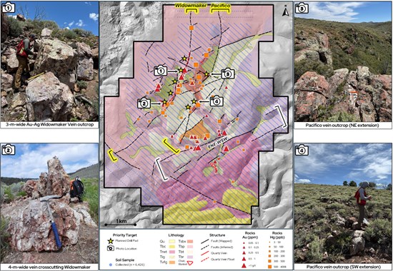
Figure 1: Geological map of Table Mountain showing preliminary drill pad locations, soil sampling coverage and rock-sample gold and mercury values, with photographs of epithermal vein exposures along the Widowmaker and Pacifico corridors.
To view an enhanced version of this graphic, please visit:
https://images.newsfilecorp.com/files/11439/316842_eee0ddb23494ab0c_002full.jpg
Ground Gravity and UAV Magnetic Results
The gravity survey delineates a broad positive anomaly, approximately four kilometres by two kilometres, that closely coincides with Table Mountain's spectrally mapped hydrothermal alteration footprint (Figure 2). Field observations document intensely silicified volcanic rocks, silica-cemented hydrothermal breccias and extensive veining within this footprint.
The UAV magnetic survey delineates multiple kilometre-scale magnetic lows and pronounced magnetic gradients associated with the Widowmaker, Pacifico and ENE-WSW structural corridors (Figure 3). These features overlap discrete gravity highs and coincide with mapped faults, intense silicification and epithermal veins.
Coincident gravity highs and magnetic lows are recognized exploration criteria in low-sulphidation epithermal gold-silver systems (Christie et al., 2019; Kellett and Bromley, 2019). At Table Mountain, the combined response is consistent with increased rock density through silica addition and pore-space filling, accompanied by hydrothermal destruction of magnetite (Allis, 1990).
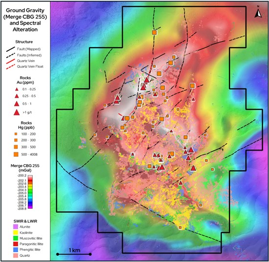
Figure 2: Ground gravity overlain by hydrothermal alteration footprint, Au- and Hg-in rocks, and structure. The broad gravity high closely coincides with much of the hydrothermal alteration footprint and extends beneath an area of Quaternary cover.
To view an enhanced version of this graphic, please visit:
https://images.newsfilecorp.com/files/11439/316842_eee0ddb23494ab0c_003full.jpg
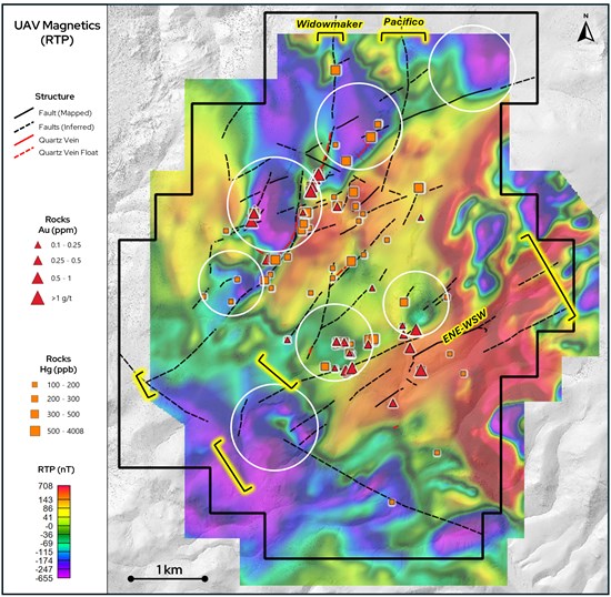
Figure 3: UAV magnetic map (reduced to pole) showing the Widowmaker, Pacifico and ENE-WSW structural corridors, and Au- and Hg-in-rocks. White circles highlight gravity high anomalies that overlap magnetic lows along the priority corridors.
To view an enhanced version of this graphic, please visit:
https://images.newsfilecorp.com/files/11439/316842_eee0ddb23494ab0c_004full.jpg
Initial CSAMT Results
Zonge International is conducting approximately 15 line-kilometres of CSAMT surveying across priority target trends. Initial results from Line 2 ("L2") help define the Widowmaker, Pacifico and ENE-WSW corridors at depth through prominent resistive features and sharp resistivity contrasts (Figure 4). Their interpreted positions align with epithermal veins, intense alteration, previously reported rock geochemistry and coincident gravity highs and magnetic lows, strengthening their priority for maiden drilling.
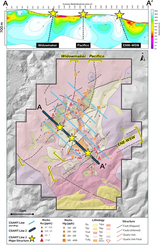
Figure 4: Initial CSAMT Line 2 (A-A′) resistivity section and geological map showing deep resistive features correlating with the Widowmaker, Pacifico and ENE-WSW corridors. Yellow stars mark corridor crossings; dashed lines on the section show interpreted structural projections.
To view an enhanced version of this graphic, please visit:
https://images.newsfilecorp.com/files/11439/316842_eee0ddb23494ab0c_005full.jpg
Next Steps
The Company will complete the CSAMT survey and integrate the results with geological mapping, soil and rock geochemistry, gravity and magnetics to refine drill targets. Initial targeting will prioritize mapped veins, fault intersections, bends and areas of intense alteration, with geophysical results helping assess their subsurface geometry.
Survey Methods
Magee Geophysical Services LLC completed the ground gravity survey, comprising 1,688 stations on a 100-metre by 100-metre grid. MWH Geo-Surveys International Inc. completed approximately 780 line-kilometres of UAV magnetic surveying along northwest-southeast lines spaced 25 metres apart.
Wave Geophysics completed final processing and three-dimensional inversion modelling of the gravity and magnetic datasets. Two-dimensional products include complete Bouguer and residual gravity maps, total magnetic intensity and reduced-to-pole magnetic maps, and vertical-derivative and tilt products. These products and the three-dimensional models support interpretation of subsurface density and magnetic-property contrasts, geological boundaries and structural controls on alteration.
Zonge International is conducting approximately 15 line-kilometres of scalar CSAMT surveying. The initial Line 2 section uses 50-metre receiver dipoles and a 1,500-metre transmitter bipole. Results are presented as a two-dimensional resistivity inversion model.
The geophysical interpretations incorporate comparison with geological mapping, spectral alteration data and rock geochemistry. Interpretations remain preliminary: differences in rock type may also contribute to the responses, and modelled features do not establish the presence, grade or continuity of mineralization.
References
Christie, A.B., Simpson, M.P., Barker, R.G. and Brathwaite, R.L. (2019). Exploration for epithermal Au-Ag deposits in New Zealand: history and strategy. New Zealand Journal of Geology and Geophysics, 62(4), 414-441.
Kellett, R.L. and Bromley, C.J. (2019; first published online in 2018). Geophysical signatures of New Zealand epithermal Au-Ag deposits, and methods for new exploration. New Zealand Journal of Geology and Geophysics, 62(4).
Allis, R.G. (1990). Geophysical anomalies over epithermal systems. Journal of Geochemical Exploration, 36(1-3), 339-374.
Qualified Person
Colin Smith, M.Sc., P.Geo., a Qualified Person under National Instrument 43-101, has reviewed and approved the technical information contained in this news release. Mr. Smith is not independent of the Company, as he serves as its CEO and Director and owns securities of the Company.
About Toogood Gold Corp.
Toogood Gold Corp. is a Canadian exploration company focused on the discovery and advancement of high-grade gold systems in tier-one mining jurisdictions. The Company has two core areas of focus: the Table Mountain Project in Nevada, where the Company has an option to earn a 100% interest in a large, undrilled low-sulphidation epithermal system with extensive surface alteration and multiple mineralized vein exposures; and the district-scale Toogood Gold Project in Newfoundland, where the Company has an option to earn a 100% interest in a 164 km² land package covering a highly underexplored gold district with multiple target areas and demonstrated gold prospectivity.
On Behalf of the Board of Directors
Colin Smith
Director & CEO
Toogood Gold Corp.
Additional information about Toogood Gold Corp. can be found at www.sedarplus.ca.
Forward-Looking Information
This press release contains "forward-looking information" within the meaning of applicable Canadian securities legislation. Generally, forward looking information can be identified by the use of forward looking terminology such as "plans", "expects" or "does not expect", "is expected", "budget", "scheduled", "estimates", "forecasts", "intends", "anticipates" or "does not anticipate", or "believes", or variations of such words and phrases or state that certain acts, events or results "may", "could", "would", "might" or "will be taken", "occur" or "be achieved".
Forward-looking statements or information are subject to a variety of known and unknown risks, uncertainties and other factors that could cause actual events or results to differ from those reflected in the forward-looking statements or information, including, without limitation, the need for additional capital by the Company through financings, and the risk that such funds may not be raised; the speculative nature of exploration and the stages of the Company's properties; the effect of changes in commodity prices; regulatory risks that development of the Company's material properties will not be acceptable for social, environmental or other reasons; availability of equipment (including drills) and personnel to carry out work programs; and that each stage of work will be completed within expected time frames. This list is not exhaustive of the factors that may affect any of the Company's forward-looking statements or information. Although the Company has attempted to identify important factors that could cause actual results to differ materially, there may be other factors that cause results not to be as anticipated, estimated, described or intended. Accordingly, readers should not place undue reliance on forward-looking statements or information.
The Company's forward-looking statements and information are based on the assumptions, beliefs, expectations and opinions of management as of the date of this news release, and other than as required by applicable securities laws, the Company does not assume any obligation to update forward-looking statements and information if circumstances or management's assumptions, beliefs, expectations or opinions should change, or changes in any other events affecting such statements or information.
Neither TSX Venture Exchange nor its Regulation Services Provider (as that term is defined in the policies of TSX Venture Exchange) accepts responsibility for the adequacy or accuracy of this release.

To view the source version of this press release, please visit https://www.newsfilecorp.com/release/316842

© 2026 Canjex Publishing Ltd. All rights reserved.