Vancouver, British Columbia and Melbourne, Australia--(Newsfile Corp. - July 15, 2026) - Southern Cross Gold Consolidated Ltd (TSX: SXGC) (ASX: SX2) (OTCQX: SXGCF) (FSE: MV3) ("SXGC", "SX2" or the "Company") announces results from two drill holes from the 100%-owned Redcastle Project in Victoria (Figures 1 to 7). Redcastle is located 64 km to the NNW of the Company's Sunday Creek project (Figure 7).
Best results included 26.2 g/t Au over 0.14 m from 112.98 m and 15.4 g/t Au over 0.22 m from 321.84 m in drill hole SDDRE016 at the Laura prospect, two of eight individual high-grade gold intervals from that hole, which confirmed Costerfield-style gold-antimony mineralization including visible gold over more than 250 m of vertical extent. The true thickness of the mineralized intervals is interpreted to be approximately 70% to 85% of the sampled thickness for all reported holes.
Four High Level Takeaways:
First deep test confirms the system. SDDRE016 is among the first holes to test the Laura prospect below the historic workings and water table, intersecting gold and antimony bearing vein mineralisation over more than 250 m of vertical extent, with visible gold in subvertical extensional veins reminiscent of Costerfield-style mineralization.
High grades at depth. Eight separate high-grade gold intervals were returned from SDDRE016, headlined by 26.2 g/t Au over 0.14 m from 112.98 m, 15.4 g/t Au over 0.22 m from 321.84 m and 5.0 g/t Au with 0.33% Sb over 0.10 m from 294.11 m, demonstrating that the high grades historically mined at surface continue at depth.
A district-scale opportunity. Redcastle hosts 14 individual reefs across a 900 m cross-strike corridor and combined historic workings over 17 km of strike, the great majority of which has never been drill tested below approximately 50 m depth, providing a strong pipeline of targets along strike from Costerfield.
Regional growth in the Victorian epizonal goldfields alongside Sunday Creek. Eleven drill rigs are now operational across the 10km sitrike at Sunday Creek, with two rigs dedicated to targets outside the core drill area up to 8 km to the east, as the Company advances its 200,000 m drill program through to Q1 2027 with results pending from 71 holes.
Michael Hudson, President & CEO, states: "These are the first deep holes ever drilled beneath the Laura prospect at Redcastle, and they have done exactly what we hoped. We have intersected high-grade gold, visible gold and antimony in the same Costerfield-style vein architecture that has made this corner of Victoria one of the highest-grade gold endowments on earth.
"Redcastle sits just 7 km along strike from Costerfield, on a parallel structure, with 14 reefs over a 900 m wide corridor and 17 km of historic workings that have barely been scratched below the water table. SDDRE016 tells us the system has real depth potential, and it is only the beginning of a sustained regional campaign.
"With eleven rigs now turning across our landholding and results pending from 71 holes, Redcastle adds a genuine second engine of discovery alongside Sunday Creek as we drill through to the first quarter of 2027."
For Those Who Like the Details - Highlights:
- SDDRE016 (Laura) tested the mineralized western limb of the NNW-SSE trending Redcastle Anticline and a large IP chargeability body modelled from 155 m. The hole intersected steeply west-dipping bedding-parallel laminated veins and steep extensional veins hosting pyrite-arsenopyrite mineralization with associated gold and antimony from 102 m to 360 m, before passing through the anticlinal hinge at approximately 380 m to a final depth of 410.45 m. Highlights include:
- 2.1 g/t Au & 0.81% Sb over 0.10 m from 103.30 m
- 2.5 g/t Au over 0.35 m from 110.91 m
- 26.2 g/t Au over 0.14 m from 112.98 m
- 1.1 g/t Au over 0.10 m from 154.45 m
- 5.0 g/t Au & 0.33% Sb over 0.10 m from 294.11 m
- 15.4 g/t Au over 0.22 m from 321.84 m
- 4.8 g/t Au over 0.21 m from 329.57 m
- 2.8 g/t Au over 0.14 m from 334.50 m
- SDDRE017 (Beautiful Venus) was drilled west to east to test below historic workings intersected at approximately 42.5 m vertical depth in earlier hole MDDRE014. Trace antimony was observed in a steep extensional vein at 66.5 m down hole, and low-tenor gold was returned, with a best result of 0.91 g/t Au over 0.29 m from 140.71 m. The hole confirms the structural setting and vein style and will help vector future drilling at the prospect.
Drill Hole Discussion
Two drill holes are reported here targeting the Laura and Beautiful Venus prospects within the broader Redcastle Project, drilled in a west-to-east orientation to optimize high intersection angles across the steeply dipping vein architecture.
SDDRE016
SDDRE016 was designed to test the mineralized western limb of an NNW-SSE trending Redcastle Anticline, targeting at depth several bedding-parallel to sub-parallel structures expressed as workings at surface, together with a large IP chargeability body modelled from 155 m. The hole intersected steeply west-dipping bedding and vein-hosted pyrite-arsenopyrite mineralization from 102 m to 360 m, before passing through an anticlinal hinge at approximately 380 m to a final depth of 410.45 m. Mineralized veins were absent between the hinge zone and the end of hole.
Three styles of mineralized features were logged: a deformed black shale unit, bedding-parallel laminated veins, and steep to vertical extensional veins. Mineralization is punctuated by arsenopyrite-pyrite halos developed around veins, with antimony and gold hosted within the veins themselves. Visible gold was intersected in subvertical extensional veins fringed by arsenopyrite haloes, reminiscent of Costerfield-style mineralization.
As one of the first holes to test the Laura prospect to this depth, SDDRE016 is highly encouraging. The headline 26.2 g/t Au intercept lies at a vertical depth of approximately 86 m below surface, while deeper high-grade veins extend the mineralized system to more than 250 m of vertical extent. Further drilling is required to define strike and dip continuity between intercepts. Better results included:
- 2.1 g/t Au & 0.81% Sb over 0.10 m from 103.30 m
- 2.5 g/t Au & 0.00% Sb over 0.35 m from 110.91 m
- 26.2 g/t Au & 0.01% Sb over 0.14 m from 112.98 m
- 1.1 g/t Au & 0.06% Sb over 0.10 m from 154.45 m
- 5.0 g/t Au & 0.33% Sb over 0.10 m from 294.11 m
- 15.4 g/t Au & 0.03% Sb over 0.22 m from 321.84 m
- 4.8 g/t Au & 0.00% Sb over 0.21 m from 329.57 m
- 2.8 g/t Au & 0.00% Sb over 0.14 m from 334.50 m
SDDRE017
SDDRE017 tested the Beautiful Venus prospect, drilled west to east where the previous hole MDDRE014 intersected old workings at a vertical depth of 42.5 m.
Trace antimony was observed in a steep extensional vein at 66.5 m down hole. The hole returned low-tenor gold, with a best individual result of 0.91 g/t Au over 0.29 m from 140.71 m, and confirms the structural and vein setting for future targeting at the prospect.
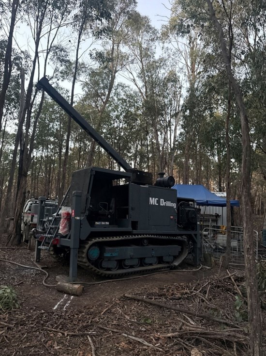
Figure 1: Regional drill rig set up at Redcastle.
To view an enhanced version of this graphic, please visit:
https://images.newsfilecorp.com/files/11541/305229_a477600464d2eb23_003full.jpg
About Redcastle
The Redcastle Gold-Antimony Project, located 110 km north of Melbourne and 64 km NNW of Sunday Creek in central Victoria. The project comprises three granted exploration licences (EL5546, EL7498 and EL7499) covering a combined 7,500 hectares. The project straddles the northern tenements of Alkane Resources' Costerfield gold-antimony mine, sitting 7 km along strike from Costerfield on a parallel north-south structure and 24 km east of Agnico Eagle's Fosterville mine.
The Redcastle goldfield is a structurally controlled epizonal system, centred on the western limb of the plunging Redcastle Anticline and hosted in thinly interbedded Silurian sandstones and mudstones. Gold mineralization occurs in bedding-parallel laminated quartz veins striking ~345° and dipping steeply westward, containing quartz, carbonate, visible gold and stibnite, with a narrow arsenopyrite-pyrite halo in the surrounding host rock. The field is distinguished by closely spaced reefs, with 14 individual reefs occurring across a 900 m cross-strike distance on the western side, and combined historic workings extending over 17 km of strike.
First discovered in 1859, Redcastle is one of the most significant historic epizonal high-grade goldfields in Victoria. Reef mining during the 1859 to 1865 period delivered exceptional grades from narrow, continuous structures: the Welcome Group of mines extracted 20,583 oz at 254.6 g/t Au over 2 km of strike length down to a maximum depth of 125 m, and the Redcastle Gold Mining Company produced 35,000 oz at 33 g/t Au from Clarke's Reef. Historic mining was shallow (average ~55 m depth) with individual reef widths typically under 0.6 m and average mining widths of approximately 1 m.
Further Information
Further discussion and analysis of the Redcastle project is available at https://www.southerncrossgold.com/projects/redcastle on the SXGC website. These data, along with an interview on these results with President & CEO/Managing Director Michael Hudson can be viewed at www.southerncrossgold.com.
No upper gold grade cut is applied in the averaging and intervals are reported as drill thickness. However, during future Mineral Resource studies, the requirement for assay top cutting will be assessed. The Company notes that due to rounding of assay results to one decimal place, minor variations in calculated composite grades may occur.
Figures 1 to 7 show project location, plan and longitudinal views of drill results reported here and Tables 1 to 2 provide collar and assay data. The true thickness of the mineralized intervals reported individually as estimated true widths ("ETW"), otherwise they are interpreted to be approximately 70% to 85% of the sampled thickness for other reported holes. No compositing has been undertaken.
Critical Metal Epizonal Gold-Antimony Deposits
Redcastle (Figure 7) is an epizonal gold-antimony deposit formed in the late Devonian (like Fosterville, Costerfield and Sunday Creek), 60 million years later than mesozonal gold systems formed in Victoria (for example Ballarat and Bendigo). Epizonal deposits are a form of orogenic gold deposit classified according to their depth of formation: epizonal (<6 km), mesozonal (6 km to 12 km) and hypozonal (>12 km).
Epizonal deposits in Victoria often have associated high levels of the critical metal, antimony, and Sunday Creek and Redcastle are no exception. China claims a 56 per cent share of global mined supplies of antimony, according to a 2023 European Union study. Antimony features highly on the critical minerals lists of many countries including Australia, the United States of America, Canada, Japan and the European Union. Australia ranks seventh for antimony production despite all production coming from a single mine at Costerfield in Victoria, located nearby to all SXGC projects. Antimony alloys with lead and tin which results in improved properties for solders, munitions, bearings and batteries. Antimony is a prominent additive for halogen-containing flame retardants. Adequate supplies of antimony are critical to the world's energy transition, and to the high-tech industry, especially the semi-conductor and defence sectors where it is a critical additive to primers in munitions.
About Southern Cross Gold Consolidated Limited (TSX: SXGC) (ASX: SX2) (OTCQX: SXGCF) (FSE: MV3)
Southern Cross Gold Consolidated Ltd. (TSX: SXGC) (ASX: SX2) (OTCQX: SXGCF) is defining a leading gold-antimony project at the Sunday Creek Gold-Antimony Project, located 60 km north of Melbourne. Sunday Creek is a significant gold and antimony drill discovery in a Tier 1 location, with high-grade drill results including 88 composite intersections exceeding 100 g/t Au from 126.3 km of drilling. The mineralization follows a "Golden Ladder" structure over 12 km of strike length, with structures tested from surface to 1,200 m depth.
Sunday Creek's strategic value is enhanced by its dual-metal profile. The Company has a critical mineral the Western world needs. This has gained increased significance following China's export restrictions on antimony, a critical metal for defence and semiconductor applications. Southern Cross' inclusion in the US Defense Industrial Base Consortium (DIBC) and Australia's AUKUS-related legislative changes position it as a potential key Western antimony supplier.
Technical fundamentals further strengthen the investment case, with preliminary metallurgical work showing non-refractory mineralization suitable for conventional processing and gold recoveries of 93% to 98% through gravity and flotation.
With a strong cash position, 1,392 Ha of strategic freehold land ownership, and a large 200 km drill program planned through Q1 2027, SXGC is well-positioned to advance this globally significant gold-antimony discovery in a tier-one jurisdiction, delivering milestone by milestone.
- Ends -
For ASX Compliance: This announcement has been approved for release by the Board of Southern Cross Gold Consolidated Ltd.
NI 43-101 Technical Background and Qualified Person
Kenneth Bush, Head of Exploration for SXGC, a Member of Australian Institute of Geoscientists and a Registered Professional Geologist in the fields of Mining and Exploration (#10315), is the Qualified Person as defined by the NI 43-101. Mr Bush has prepared, reviewed, verified and approved the technical contents of this release.
Analytical samples are transported to the Bendigo facility of On Site Laboratory Services ("On Site") which operates under both an ISO 9001 and NATA quality systems. Samples were prepared and analyzed for gold using the fire assay technique (PE01S method; 25 gram charge), followed by measuring the gold in solution with flame AAS equipment. Samples for multi-element analysis (BM011 and over-range methods as required) use aqua regia digestion and ICP-MS analysis. The QA/QC program of Southern Cross Gold consists of the systematic insertion of certified standards of known gold content, blanks within interpreted mineralized rock and quarter core duplicates. In addition, On Site inserts blanks and standards into the analytical process.
SXGC considers that both gold and antimony that are included in the gold equivalent calculation ("AuEq") have reasonable potential to be recovered and sold at Redcastle, given current geochemical understanding, historic production statistics and geologically analogous mining operations. The Costerfield mine corridor, now owned by Alkane Resources (previously Mandalay Resources) contains two million ounces of equivalent gold (Mandalay Resources Q3 2021 Results), and in 2020 was the sixth highest-grade global underground mine and a top 5 global producer of antimony.
SXGC considers that it is appropriate to adopt the same gold equivalent variables as Mandalay Resources Ltd in its 2024 End of Year Mineral Reserves and Resources Press Release, dated February 20, 2025. The gold equivalence formula used by Mandalay Resources was calculated using Costerfield's 2024 production costs, using a gold price of US$2,500 per ounce, an antimony price of US$19,000 per tonne and 2024 total year metal recoveries of 91% for gold and 92% for antimony, and is as follows:
AuEq = Au (g/t) + 2.39 × Sb (%)
Based on the latest Costerfield calculation and given the similar geological styles of Redcastle mineralization and Costerfield, SXGC considers that a AuEq = Au (g/t) + 2.39 × Sb (%) is appropriate to use for the initial early stage exploration targeting of gold-antimony mineralization at Sunday Creek and Redcastle.
JORC Competent Person Statement
Information in this announcement that relates to new exploration results contained in this report is based on information compiled by Mr Kenneth Bush a Member of Australian Institute of Geoscientists and a Registered Professional Geologist in the fields of Mining and Exploration (#10315). Mr Bush has sufficient experience relevant to the style of mineralization and type of deposit under consideration, and to the activities undertaken, to qualify as a Competent Person as defined in the 2012 Edition of the Joint Ore Reserves Committee (JORC) Australasian Code for Reporting of Exploration Results, Mineral Resources and Ore Reserves. Mr Bush is Head of Exploration of Southern Cross Gold Consolidated Limited and consents to the inclusion in the report of the matters based on their information in the form and context in which it appears.
Certain information in this announcement that relates to prior exploration results is extracted from the Independent Geologist's Report dated 11 December 2024 which was issued with the consent of the Competent Person, Mr Steven Tambanis. The report is included in the Company's prospectus dated 11 December 2024 and is available at www.asx.com.au under code "SX2". The Company confirms that it is not aware of any new information or data that materially affects the information related to exploration results included in the original market announcement. The Company confirms that the form and context of the Competent Persons' findings in relation to the report have not been materially modified from the original market announcement.
The Company confirms that it is not aware of any new information or data that materially affects the information included in the original document/announcement and the Company confirms that the form and context in which the Competent Person's findings are presented have not been materially modified from the original market announcement.
Forward-Looking Statement
This news release contains forward-looking statements. Forward-looking statements involve known and unknown risks, uncertainties and assumptions and accordingly, actual results and future events could differ materially from those expressed or implied in such statements. You are hence cautioned not to place undue reliance on forward-looking statements. All statements other than statements of present or historical fact are forward-looking statements. Forward-looking statements include words or expressions such as "proposed", "will", "subject to", "near future", "in the event", "would", "expect", "prepared to" and other similar words or expressions. Factors that could cause future results or events to differ materially from current expectations expressed or implied by the forward-looking statements include general business, economic, competitive, political, social uncertainties; the state of capital markets, unforeseen events, developments, or factors causing any of the expectations, assumptions, and other factors ultimately being inaccurate or irrelevant; and other risks described in the Company's documents filed with Canadian or Australian (under code SX2) securities regulatory authorities. You can find further information with respect to these and other risks in filings made by the Company with the securities regulatory authorities in Canada or Australia (under code SX2), as applicable, and available for the Company in Canada at www.sedarplus.ca or in Australia at www.asx.com.au (under code SX2). Documents are also available at www.southerncrossgold.com The Company disclaims any obligation to update or revise these forward-looking statements, except as required by applicable law.
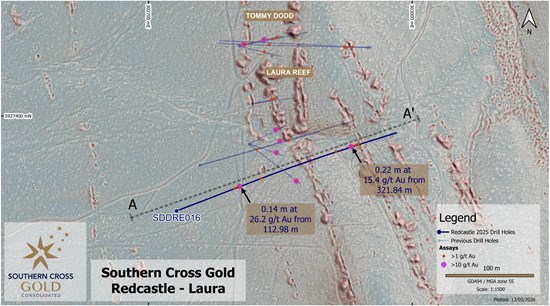
Figure 2: Redcastle plan view showing selected results from holes SDDRE016 with selected prior reported drill holes, hillshaded LiDAR and historic workings.
To view an enhanced version of this graphic, please visit:
https://images.newsfilecorp.com/files/11541/305229_a477600464d2eb23_004full.jpg
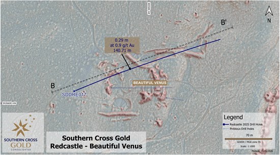
Figure 3: Redcastle plan view showing selected results from holes SDDRE017 with selected prior reported drill holes, hillshaded LiDAR and historic workings.
To view an enhanced version of this graphic, please visit:
https://images.newsfilecorp.com/files/11541/305229_a477600464d2eb23_005full.jpg
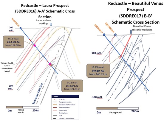
Figure 4: Redcastle Project. Prospect scale schematic cross sections (A-A' and B-B') with results from recently drilled holes SDDRE016 and SDDRE017
To view an enhanced version of this graphic, please visit:
https://images.newsfilecorp.com/files/11541/305229_sxgc-fig4.jpg
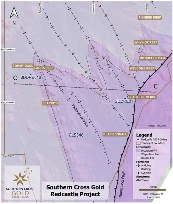
Figure 5: Redcastle Project Scale Geology. Geological section C-C' line presented with key prospects.
To view an enhanced version of this graphic, please visit:
https://images.newsfilecorp.com/files/11541/305229_a477600464d2eb23_009full.jpg
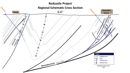
Figure 6: Redcastle Project Idealized Geological Cross Section (C-C'). Schematic not to scale.
To view an enhanced version of this graphic, please visit:
https://images.newsfilecorp.com/files/11541/305229_a477600464d2eb23_010full.jpg
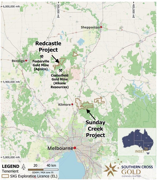
Figure 7: Location of the Redcastle Gold-Antimony Project, along with the 100% owned Sunday Creek Project.
To view an enhanced version of this graphic, please visit:
https://images.newsfilecorp.com/files/11541/305229_a477600464d2eb23_011full.jpg
Table 1: Drill collar summary table for recent drill holes in progress.
| Hole ID | Depth
(m) | Prospect | East
GDA94 Z55 | North
GDA94 Z55 | Elevation
(m) | Dip | Azimuth
GDA94 Z55 |
| SDDRE016 | 410.45 | Redcastle | 302735 | 5927298 | 217 | -50.3 | 67.7 |
| SDDRE017 | 359.8 | Beautiful Venus | 305388.6 | 5926618 | 206.62 | -50.9 | 68.9 |
Table 2: All individual assays reported from SDDRE016 and SDDRE017 reported here >0.1g/t AuEq. Individual assay and sample intervals are reported to two decimal places.
| Hole number | From (m) | To (m) | Interval (m) | Au g/t | Sb % | AuEq g/t |
| SDDRE016 | 11.26 | 11.76 | 0.5 | 0.13 | 0.002 | 0.14 |
| SDDRE016 | 72.98 | 73.09 | 0.11 | 0.23 | 0.002 | 0.23 |
| SDDRE016 | 102.24 | 102.53 | 0.29 | 0.51 | 0.003 | 0.52 |
| SDDRE016 | 102.95 | 103.3 | 0.35 | 0.1 | 0.002 | 0.1 |
| SDDRE016 | 103.3 | 103.4 | 0.1 | 2.12 | 0.81 | 4.06 |
| SDDRE016 | 103.4 | 104.33 | 0.93 | 0.04 | 0.036 | 0.13 |
| SDDRE016 | 104.33 | 104.43 | 0.1 | 0.24 | 0.004 | 0.25 |
| SDDRE016 | 110.13 | 110.4 | 0.27 | 0.17 | 0.002 | 0.17 |
| SDDRE016 | 110.4 | 110.79 | 0.39 | 0.46 | 0.001 | 0.46 |
| SDDRE016 | 110.79 | 110.91 | 0.12 | 0.71 | 0.001 | 0.71 |
| SDDRE016 | 110.91 | 111.26 | 0.35 | 2.48 | 0.004 | 2.49 |
| SDDRE016 | 111.26 | 111.8 | 0.54 | 0.37 | 0.002 | 0.38 |
| SDDRE016 | 111.8 | 112.38 | 0.58 | 0.12 | 0.002 | 0.13 |
| SDDRE016 | 112.38 | 112.8 | 0.42 | 0.24 | 0.002 | 0.24 |
| SDDRE016 | 112.8 | 112.98 | 0.18 | 0.34 | 0.001 | 0.34 |
| SDDRE016 | 112.98 | 113.12 | 0.14 | 26.2 | 0.007 | 26.22 |
| SDDRE016 | 154.45 | 154.55 | 0.1 | 1.05 | 0.064 | 1.2 |
| SDDRE016 | 154.55 | 154.74 | 0.19 | 0.38 | 0.024 | 0.44 |
| SDDRE016 | 168.45 | 168.56 | 0.11 | 0.5 | 0.001 | 0.5 |
| SDDRE016 | 179.6 | 179.71 | 0.11 | 0.51 | 0.003 | 0.52 |
| SDDRE016 | 181.45 | 181.78 | 0.33 | 0.91 | 0.004 | 0.92 |
| SDDRE016 | 185.92 | 186.71 | 0.79 | 0.34 | 0.002 | 0.35 |
| SDDRE016 | 263.73 | 263.83 | 0.1 | 0.3 | 0.002 | 0.31 |
| SDDRE016 | 294.11 | 294.21 | 0.1 | 4.98 | 0.33 | 5.77 |
| SDDRE016 | 310.34 | 310.45 | 0.11 | 0.45 | 0.009 | 0.47 |
| SDDRE016 | 311.05 | 311.22 | 0.17 | 0.58 | 0.003 | 0.59 |
| SDDRE016 | 311.22 | 311.42 | 0.2 | 0.62 | 0.006 | 0.63 |
| SDDRE016 | 311.42 | 311.72 | 0.3 | 0.2 | 0.003 | 0.21 |
| SDDRE016 | 311.72 | 312.82 | 1.1 | 0.1 | 0.004 | 0.11 |
| SDDRE016 | 321.84 | 322.06 | 0.22 | 15.4 | 0.026 | 15.46 |
| SDDRE016 | 322.59 | 322.7 | 0.11 | 0.75 | 0.005 | 0.76 |
| SDDRE016 | 329.16 | 329.27 | 0.11 | 0.31 | 0.002 | 0.32 |
| SDDRE016 | 329.57 | 329.78 | 0.21 | 4.8 | 0.005 | 4.81 |
| SDDRE016 | 331.14 | 331.31 | 0.17 | 0.13 | 0.002 | 0.14 |
| SDDRE016 | 332.4 | 333.5 | 1.1 | 0.1 | 0.002 | 0.1 |
| SDDRE016 | 334.5 | 334.64 | 0.14 | 2.84 | 0.002 | 2.84 |
| SDDRE016 | 337.62 | 337.85 | 0.23 | 0.47 | 0.004 | 0.48 |
| SDDRE016 | 338.18 | 338.3 | 0.12 | 0.63 | 0.004 | 0.64 |
| SDDRE016 | 344.11 | 344.34 | 0.23 | 0.79 | 0.004 | 0.8 |
| SDDRE016 | 351.06 | 351.32 | 0.26 | 0.77 | 0.004 | 0.78 |
| SDDRE016 | 363.27 | 363.84 | 0.57 | 0.18 | 0.002 | 0.18 |
| SDDRE016 | 390.4 | 391.2 | 0.8 | 0.1 | 5E-04 | 0.1 |
| SDDRE016 | 394.48 | 394.75 | 0.27 | 0.29 | 0.001 | 0.29 |
| SDDRE017 | 66.33 | 66.57 | 0.24 | 0.16 | 0.002 | 0.16 |
| SDDRE017 | 100.5 | 101.41 | 0.91 | 0.14 | 0.001 | 0.14 |
| SDDRE017 | 101.41 | 101.73 | 0.32 | 0.15 | 0.003 | 0.16 |
| SDDRE017 | 140.71 | 141 | 0.29 | 0.91 | 0.002 | 0.91 |
JORC Table 1
Section 1 Sampling Techniques and Data
| Criteria | JORC Code explanation | Commentary |
| Sampling techniques | - Nature and quality of sampling (e.g. cut channels, random chips, or specific specialized industry standard measurement tools appropriate to the minerals under investigation, such as down hole gamma sondes, or handheld XRF instruments, etc.). These examples should not be taken as limiting the broad meaning of sampling.
- Include reference to measures taken to ensure sample representivity and the appropriate calibration of any measurement tools or systems used.
- Aspects of the determination of mineralization that are Material to the Public Report.
- In cases where 'industry standard' work has been done this would be relatively simple (e.g. 'reverse circulation drilling was used to obtain 1 m samples from which 3 kg was pulverized to produce a 30 g charge for fire assay'). In other cases more explanation may be required, such as where there is coarse gold that has inherent sampling problems. Unusual commodities or mineralization types (e.g. submarine nodules) may warrant disclosure of detailed information.
| - Sampling has been conducted on drill core (half core for >90% and quarter core for check samples), grab samples (field samples of in-situ bedrock and boulders; including duplicate samples), trench samples (rock chips, including duplicates) and soil samples (including duplicate samples).
Locations of field samples were obtained by using a GPS, generally to an accuracy of within 5 metres. Drill hole and trench locations have been confirmed to <1 metre using a differential GPS.
Samples locations have also been verified by plotting locations on the high-resolution Lidar maps - Drill core is marked for cutting and cut using an automated diamond saw used by Company staff in Kilmore.
Samples are bagged at the core saw and transported to the Bendigo On Site Laboratory for assay.
At On Site samples are crushed using a jaw crusher combined with a rotary splitter and a 1 kg split is separated for pulverizing (LM5) and assay. - Standard fire assay techniques are used for gold assay on a 30 g charge by experienced staff (used to dealing with high sulfide and stibnite-rich charges). On Site gold method by fire assay code PE01S.
- Screen fire assay is used to understand gold grain-size distribution where coarse gold is evident.
- ICP-OES is used to analyse the aqua regia digested pulp for an additional 12 elements (method BM011) and over-range antimony is measured using flame AAS (method known as B050).
- Soil samples were sieved in the field and an 80-mesh sample bagged and transported to ALS Global laboratories in Brisbane for super-low level gold analysis on a 50 g samples by method ST44 (using aqua regia and ICP-MS).
- Grab and rock chip samples are generally submitted to On Site Laboratories for standard fire assay and 12 element ICP-OES as described above.
|
| Drilling techniques | - Drill type (e.g. core, reverse circulation, open-hole hammer, rotary air blast, auger, Bangka, sonic, etc.) and details (e.g. core diameter, triple or standard tube, depth of diamond tails, face-sampling bit or other type, whether core is oriented and if so, by what method, etc.).
| - HQ or NQ diameter diamond drill core, oriented using Axis Champ orientation tool with the orientation line marked on the base of the drill core by the driller/offsider.
A standard 3 metre core barrel has been found to be most effective in both the hard and soft rocks in the project.
|
| Drill sample recovery | - Method of recording and assessing core and chip sample recoveries and results assessed.
- Measures taken to maximise sample recovery and ensure representative nature of the samples.
- Whether a relationship exists between sample recovery and grade and whether sample bias may have occurred due to preferential loss/gain of fine/coarse material.
| - Core recoveries were maximized using HQ or NQ diamond drill core with careful control over water pressure to maintain soft-rock integrity and prevent loss of fines from soft drill core. Recoveries are determined on a metre-by-metre basis in the core shed using a tape measure against marked up drill core checking against driller's core blocks.
- Plots of grade versus recovery and RQD (described below) show no trends relating to loss of drill core, or fines.
|
| Logging | - Whether core and chip samples have been geologically and geotechnically logged to a level of detail to support appropriate Mineral Resource estimation, mining studies and metallurgical studies.
- Whether logging is qualitative or quantitative in nature. Core (or costean, channel, etc.) photography.
- The total length and percentage of the relevant intersections logged.
| - Geotechnical logging of the drill core takes place on racks in the company core shed.
Core orientations marked at the drill rig are checked for consistency, and base of core orientation lines are marked on core where two or more orientations match within 10 degrees.
Core recoveries are measured for each metre
RQD measurements (cumulative quantity of core sticks > 10 cm in a metre) are made on a metre-by-metre basis. - Each tray of drill core is photographed (wet and dry) after it is fully marked up for sampling and cutting.
- The ½ core cutting line is placed approximately 10 degrees above the orientation line so the orientation line is retained in the core tray for future work.
- Geological logging of drill core includes the following parameters:
Rock types, lithology
Alteration
Structural information (orientations of veins, bedding, fractures using standard alpha-beta measurements from orientation line; or, in the case of un-oriented parts of the core, the alpha angles are measured)
Veining (quartz, carbonate, stibnite)
Key minerals (visible under hand lens, e.g. gold, stibnite) - 100% of drill core is logged for all components described above into the company MX logging database.
- Logging is fully quantitative, although the description of lithology and alteration relies on visible observations by trained geologists.
- Each tray of drill core is photographed (wet and dry) after it is fully marked up for sampling and cutting.
- Logging is considered to be at an appropriate quantitative standard to use in future studies.
|
| Sub-sampling techniques and sample preparation | - If core, whether cut or sawn and whether quarter, half or all core taken.
- If non-core, whether riffled, tube sampled, rotary split, etc. and whether sampled wet or dry.
- For all sample types, the nature, quality and appropriateness of the sample preparation technique.
- Quality control procedures adopted for all sub-sampling stages to maximise representivity of samples.
- Measures taken to ensure that the sampling is representative of the in situ material collected, including for instance results for field duplicate/second-half sampling.
- Whether sample sizes are appropriate to the grain size of the material being sampled.
| - Drill core is typically half-core sampled using an Almonte core saw. The drill core orientation line is retained.
- Quarter core is used when taking sampling duplicates (termed FDUP in the database).
- Sampling representivity is maximized by always taking the same side of the drill core (whenever oriented), and consistently drawing a cut line on the core where orientation is not possible. The field technician draws these lines.
- Sample sizes are maximized for coarse gold by using half core, and using quarter core and half core splits (laboratory duplicates) allows an estimation of nugget effect.
- In mineralized rock the company uses approximately 10% of ¼ core duplicates, certified reference materials (suitable OREAS materials), laboratory sample duplicates and instrument repeats.
- In the soil sampling program duplicates were obtained every 20th sample and the laboratory inserted low-level gold standards regularly into the sample flow.
|
| Quality of assay data and laboratory tests | - The nature, quality and appropriateness of the assaying and laboratory procedures used and whether the technique is considered partial or total.
- For geophysical tools, spectrometers, handheld XRF instruments, etc., the parameters used in determining the analysis including instrument make and model, reading times, calibrations factors applied and their derivation, etc.
- Nature of quality control procedures adopted (e.g. standards, blanks, duplicates, external laboratory checks) and whether acceptable levels of accuracy (i.e. lack of bias) and precision have been established.
| - The fire assay technique for gold used by On Site is a globally recognized method, and over-range follow-ups including gravimetric finish and screen fire assay are standard. Of significance at the On Site laboratory is the presence of fire assay personnel who are experienced in dealing with high sulfide charges (especially those with high stibnite contents) - this substantially reduces the risk of inaccurate reporting in complex sulfide-gold charges.
- Where screen fire assay is used, this assay will be reported instead of the original fire assay.
- The ICP-OES technique is a standard analytical technique for assessing elemental concentrations. The digest used (aqua regia) is excellent for the dissolution of sulfides (in this case generally stibnite, pyrite and trace arsenopyrite), but other silicate-hosted elements, in particular vanadium (V), may only be partially dissolved. These silicate-hosted elements are not important in the determination of the quantity of gold, antimony, arsenic or sulphur.
- A portable XRF has been used in a qualitative manner on drill core to ensure appropriate core samples have been taken (no pXRF data are reported or included in the MX database).
- Acceptable levels of accuracy and precision have been established using the following methods
¼ duplicates - half core is split into quarters and given separate sample numbers (commonly in mineralized core) - low to medium gold grades indicate strong correlation, dropping as the gold grade increases over 40 g/t Au.
Blanks - blanks are inserted after visible gold and in strongly mineralized rocks to confirm that the crushing and pulping are not affected by gold smearing onto the crusher and LM5 swing mill surfaces. Results are excellent, generally below detection limit and a single sample at 0.03 g/t Au.
Certified Reference Materials - OREAS CRMs have been used throughout the project including blanks, low (<1 g/t Au), medium (up to 5 g/t Au) and high-grade gold samples (> 5 g/t Au). Results are automatically checked on data import into the MX database to fall within 2 standard deviations of the expected value.
Laboratory splits - On Site conducts splits of both coarse crush and pulp duplicates as quality control and reports all data. In particular, high Au samples have the most repeats.
Laboratory CRMs - On Site regularly inserts their own CRM materials into the process flow and reports all data
Laboratory precision - duplicate measurements of solutions (both Au from fire assay and other elements from the aqua regia digests) are made regularly by the laboratory and reported. - Accuracy and precision have been determined carefully by using the sampling and measurement techniques described above during the sampling (accuracy) and laboratory (accuracy and precision) stages of the analysis.
- Soil sample company duplicates and laboratory certified reference materials all fall within expected ranges.
|
| Verification of sampling and assaying | - The verification of significant intersections by either independent or alternative company personnel.
- The use of twinned holes.
- Documentation of primary data, data entry procedures, data verification, data storage (physical and electronic) protocols.
- Discuss any adjustment to assay data.
| - The Independent Geologist has visited the project drill sites and inspected drill core held at the Kilmore core shed.
- Visual inspection of drill intersections matches both the geological descriptions in the database and the expected assay data (for example, gold and stibnite visible in drill core is matched by high Au and Sb results in assays).
- In addition, on receipt of results Company geologists assess the gold, antimony and arsenic results to verify that the intersections returned expected data.
- The electronic data storage in the MX database is of a high standard. Primary logging data are entered directly by the geologists and field technicians and the assay data are electronically matched against sample number on return from the laboratory.
- Certified reference materials, ¼ core field duplicates (FDUP), laboratory splits and duplicates and instrument repeats are all recorded in the database.
- Adjustments to assay data are recorded by MX, and none are present (or required).
- Twinned drill holes are not available at this stage of the project.
|
| Location of data points | - Accuracy and quality of surveys used to locate drill holes (collar and down-hole surveys), trenches, mine workings and other locations used in Mineral Resource estimation.
- Specification of the grid system used.
- Quality and adequacy of topographic control.
| - Differential GPS used to locate drill collars, trenches and some workings
- Standard GPS for some field locations (grab and soils samples), verified against Lidar data.
- The grid system used throughout is Geocentric datum of Australia 1994; Map Grid Zone 55 (GDA94_Z55), also referred to as ELSG 28355. Reported azimuths also relate to MGA55 (GDA94_Z55).
- Topographic control is excellent owing to sub 10 cm accuracy from Lidar data.
|
| Data spacing and distribution | - Data spacing for reporting of Exploration Results.
- Whether the data spacing and distribution is sufficient to establish the degree of geological and grade continuity appropriate for the Mineral Resource and Ore Reserve estimation procedure(s) and classifications applied.
- Whether sample compositing has been applied.
| - The data spacing is suitable for reporting of exploration results - evidence for this is based on the improving predictability of high-grade gold-antimony intersections.
- At this time, the data spacing and distribution are not sufficient for the reporting of Mineral Resource Estimates. This however may change as knowledge of grade controls increase with future drill programs.
- Samples have not been composited. All individual assays above 0.1 g/t AuEq have been reported to two decimal places with no compositing in table 2.
|
| Orientation of data in relation to geological structure | - Whether the orientation of sampling achieves unbiased sampling of possible structures and the extent to which this is known, considering the deposit type.
- If the relationship between the drilling orientation and the orientation of key mineralized structures is considered to have introduced a sampling bias, this should be assessed and reported if material.
| - The true thickness of the mineralized intervals reported are interpreted to be approximately 70-85% of the sampled thickness.
- Drilling is oriented in an optimum direction when considering the combination of host rock orientation and apparent vein control on gold and antimony grade.
The steep nature of some of the veins may give increases in apparent thickness of some intersections, but more drilling is required to quantify. - A sampling bias is not evident from the data collected to date (drill holes cut across mineralized structures at a moderate angle).
|
| Sample security | - The measures taken to ensure sample security.
| - Drill core is delivered to the Kilmore core logging shed by either the drill contractor or company field staff. Samples are marked up and cut by company staff at the Kilmore core shed, in an automated diamond saw and bagged before loaded onto strapped secured pallets and trucked by company staff to Bendigo for submission to the laboratory. There is no evidence in any stage of the process, or in the data for any sample security issues.
|
| Audits or reviews | - The results of any audits or reviews of sampling techniques and data.
| - Continuous monitoring of CRM results, blanks and duplicates is undertaken by geologists and the company data geologist. Mr Kenneth Bush for SXG has the orientation, logging and assay data.
|
Section 2 Reporting of Exploration Results
| Criteria | JORC Code explanation | Commentary |
Mineral tenement
and land tenure
status | - Type, reference name/number, location and ownership including agreements or material issues with third parties such as joint ventures, partnerships, overriding royalties, native title interests, historical sites, wilderness or national park and environmental settings.
- The security of the tenure held at the time of reporting along with any known impediments to obtaining a licence to operate in the area.
| - The Redcastle Project comprises three granted exploration licences in central Victoria, Australia: EL5546, EL7498 and EL7499. All three are held by SXG Victoria Pty Ltd, a 100% subsidiary of Southern Cross Gold Consolidated Ltd (SXGC)
- The tenements are in good standing with no known impediments. Most of the project area covers Rushworth-Heathcote State Forest (Crown land), adjacent to but not within the Heathcote-Graytown National Park. Some private land occurs on the eastern side of the main tenement, and the south-west portion is approximately 90% private smallholdings. SXGC engages with the Taungurung Land & Waters Council under a dedicated Indigenous People's Policy, with cultural clearances completed on all drill sites prior to disturbance.
|
Exploration done by
other parties | - Acknowledgment and appraisal of exploration by other parties.
| - Mining at Redcastle commenced in 1859 with alluvial workings, transitioning to reef mining where the Welcome Group of mines reportedly produced 20,583 oz at 254.6 g/t Au over 2 km of strike from 1859 to 1865, and the Redcastle Gold Mining Company produced 35,000 oz at 33 g/t Au from Clarke's Reef (Lidgey, E.F. (1898), Special Report on the Redcastle Goldfield, Victorian Department of Mines (GSV document G21967); and Victorian Department of Mines Annual Reports (1859-1865). Production figures are historical, unverified by SXGC, and do not constitute a JORC 2012 or NI 43-101 compliant estimate). Since the introduction of the Exploration Licence system in 1965, fourteen ELs have covered ground within the current Redcastle Project. Documented modern exploration includes RC drilling (47 holes for 1,785 m), RAB drilling (31 holes for 155 m), rock chip and soil sampling (101 and 228 samples respectively), and 137 costeans with 3,731 costean samples carried out across various tenements (notably EL4594, MIN4594 and EL3316) between 2005 and 2011. Nagambie Resources Limited conducted first-pass exploration drilling prior to Core Prospecting Pty Ltd acquiring PL6415 (Laura), where Core Prospecting subsequently drilled 16 diamond holes for 1,923.2 m in 2019. SXGC (via its predecessor subsidiary Mawson Victoria Pty Ltd) commenced systematic exploration in 2020.
|
| Geology | - Deposit type, geological setting and style of
- mineralization.
| - Refer to the description in the main body of the release.
|
| Drill hole Information | - A summary of all information material to the understanding of the exploration results including a tabulation of the following
- information for all Material drill holes:
- easting and northing of the drill hole collar
- elevation or RL (Reduced Level - elevation above sea level in metres) of the drill hole collar
- dip and azimuth of the hole
- down hole length and interception depth
- hole length.
- If the exclusion of this information is justified on the basis that the information is not Material and this exclusion does not detract from the understanding of the report, the Competent Person should clearly explain why this is the case.
| - Refer to tables in the main body of the release.
|
| Data aggregation methods | - In reporting Exploration Results, weighting averaging techniques, maximum and/or minimum grade truncations (e.g. cutting of high-grades) and cut-off grades are usually Material and should be stated.
- Where aggregate intercepts incorporate short lengths of high-grade results and longer lengths of low-grade results, the procedure used for such aggregation should be stated and some typical examples of such aggregations should be shown in detail.
- The assumptions used for any reporting of metal equivalent values should be clearly stated.
| - See "Further Information" and "Metal Equivalent Calculation" in main text of press release.
|
Relationship
between
mineralization
widths and
intercept lengths | - These relationships are particularly important in the reporting of Exploration Results.
- If the geometry of the mineralization with respect to the drill hole angle is known, its nature should be reported.
- If it is not known and only the down hole lengths are reported, there should be a clear statement to this effect (e.g 'down hole
- length, true width not known').
| - See reporting of true widths in the body of the press release.
|
| Diagrams | - Appropriate maps and sections (with scales) and tabulations of intercepts should be included for any significant discovery being reported. These should include, but not be limited to a plan view of drill hole collar locations and appropriate sectional views.
| - The results of the diamond drilling are displayed in the figures in the announcement.
|
| Balanced reporting | - Where comprehensive reporting of all Exploration Results is not practicable, representative reporting of both low and high-grades and/or widths should be practiced to avoid misleading reporting of Exploration Results.
| - All results above 0.1 g/t AuEq have been tabulated in this announcement. The results are considered representative with no intended bias.
- Core loss, where material, is disclosed in tabulated drill intersections.
|
| Other substantive exploration data | - Other exploration data, if meaningful and material, should be reported including (but not limited to): geological observations; geophysical survey results; geochemical survey results; bulk samples - size and method of treatment; metallurgical test results; bulk density, groundwater, geotechnical and rock characteristics; potential deleterious or contaminating substances.
| - SXGC and predecessor Mawson Victoria have completed an extensive geophysical and remote-sensing programme over the Redcastle Project, including: ground magnetics, high-density ground gravity, gradient array IP, offset dipole-dipole IP and a 58 km² LiDAR survey which has identified over 40,000 hard rock and alluvial workings through machine learning. Reconnaissance soil and rock chip sampling at the Black Squall prospect has returned anomalous results including 0.36 g/t Au and 63 ppm Sb in soil, and float samples to 73 g/t Au and 3,500 ppm Sb. Hyperspectral analysis of drill core has been undertaken to define alteration anomalies and develop a 'near-miss' vector model.
|
| Further work | - The nature and scale of planned further work (e.g. tests for lateral extensions or depth extensions or large-scale step-out drilling).
- Diagrams clearly highlighting the areas of possible extensions, including the main geological interpretations and future drilling areas, provided this information is not commercially sensitive.
| - Planned further work at Redcastle includes additional diamond drilling programmes beyond the high-grade Laura intercepts into the approximately 17 km of untested reef systems at Redcastle, where extensive vein strike remains untested below the water table (~50 m average depth) and under approximately 50% alluvial cover.
|

To view the source version of this press release, please visit https://www.newsfilecorp.com/release/305229

© 2026 Canjex Publishing Ltd. All rights reserved.