Highlights
Infill drilling at Minto North intersected high-grade mineralization within the centre of this priority resource area:
6.01% Cu, 8.77g/t Au, and 36.6 g/t Ag (13.12% CuEq) over 1.93 m, within a broader interval of 1.49% CuEq over 33 metres in drill hole 26SCM190
Step-out drilling at Minto North intersected new mineralization beyond a previously interpreted fault, which is reinterpreted indicating potential for further expansion of mineralization southwards into an untested area:
3.43% Cu, 0.36 Au, and 47 g/t Ag (3.87% CuEq) over 3.7 m, within a broader interval of 2.25% CuEq over 13.3 metres in drill hole 26SCM205
Exploration drilling at Area 118 intersected high-grade mineralization located 125 metres from historical underground development:
A 50-metre step-out intersected 3.39% Cu, 0.61 g/t Au, and 16.5 g/t Ag (3.73% CuEq) over 6.0 m, within a broader interval 1.66% CuEq over 23.0m in drill hole 26SCM188
The planned 50,000 metre Phase 2 drill program is advancing rapidly and ahead of schedule, with >45,000 metres completed to date
Preliminary Economic Assessment Update
- Selkirk Copper's team continues to advance underground and surface mine development plans, integrated mine and mineral processing plans, waste storage facility designs, and facilities work, including capital cost, sustaining cost, and operating cost estimates to inform a Preliminary Economic Assessment ("PEA"). A key focus of this work is to fully consider the significant increase in the Mineral Resource Estimate (see July 30, 2026 News Release) into the overall plans which has led to additional planning and development work. The Company is committed to completing the PEA in Q3 2026 which will reflect the potential of a planned restart of the former Minto copper-gold-silver mine.
Vancouver, British Columbia and Pelly Crossing, Yukon--(Newsfile Corp. - August 20, 2026) - Selkirk Copper Mines Inc. (TSXV: SCMI) (FSE: IO20) (OTCQX: SKRKF) ("Selkirk Copper" or the "Company") is pleased to announce additional results from the Phase 2 drill program which commenced in May 2026, at the Minto Project in Yukon, Canada.
M. Colin Joudrie, President & CEO, commented: "In a continuation of the positive drill results from the Phase 1 program, the Phase 2 program, led by the exploration and development team, continues to expand known zones of mineralization in the central mine area with very good grade copper-gold-silver intercepts over mineable widths at Minto North and Area 118. In addition, our exploration team, working closely with our drill contractor, geoscience consultants, and site team, continues to efficiently and cost-effectively complete these substantial drill programs.
"In the last 11 months Selkirk Copper has completed over 97,000 m of diamond drilling and is on track to exceed 100,000 m by the end of August. Building on the positive results of the Phase 1 drill program and the significant growth in Measured, Indicated, and Inferred Resources described in the Mineral Resource Update of July 30, we are diligently advancing the PEA which we are targeting to complete in Q3 2026."
2026 Phase 2 Drill Program
Four drill rigs are active on the Phase 2 drill program, which commenced on May 1, 2026. This drill program is targeting 50,000 metres with a focus on expansion, exploration, and infill drilling of key target areas, as well as geotechnical data collection to support the upcoming Feasibility Study.
As of August 18, 45,299 metres of drilling has been completed in 187 holes, comprising 90% of the planned meterage. Reported here are results from holes drilled in May. Turnaround time for assay results is currently six to eight weeks. The drill program is anticipated to continue until approximately late September with assay results expected to continue being released throughout the summer and fall of 2026.
Table 1: Summary of Phase 2 Drilling Completed by Location
| Zone | Holes Completed | Meters Drilled | Holes with Assays Reported |
| Minto North | 29 | 7,227 | 7 |
| Minto East | 12 | 3,748 | 3 |
| Minto Main | 28 | 10,069 | 6 |
| Area 118 | 40 | 11,530 | 5 |
| Copper Keel | 44 | 9,323 | 8 |
| Ridgetop | 34 | 3,402 | 0 |
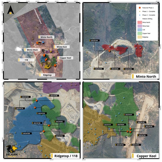
Figure 1: Plan view of the Minto Mine Property showing surface projections of mineralized zones as well as Phase 1 and Phase 2 drill collars. Drill hole results presented here are highlighted.
To view an enhanced version of this graphic, please visit:
https://images.newsfilecorp.com/files/11605/310574_068342d484b96990_001full.jpg
Minto North Drill Results
At Minto North, the Phase 2 drill program is targeting infill and expansion of priority areas within the early planned life of mine. Reported here are four drill holes targeting the 202 Lens, a high-grade mineralized zone that was delineated during the Phase 1 drill program. All four drill holes intersected significant mineralization.
Drill hole 26SCM190 was designed to infill the centre of the 202 Lens and intersected exceptional high-grade mineralization comprising 6.01% Cu, 8.77 g/t Au, and 36.6 g/t Ag (13.12% CuEq) over 1.93 m, within a broader interval of 1.49% CuEq over 33 metres. The high-grade mineralization in this intercept is associated with a domain of semi-massive bornite and chalcopyrite located within a broader interval of strongly foliated migmatite containing folioform to net-texture bornite, chalcopyrite, and magnetite. The results of this hole further delineate the extents of high-grade mineralization within this lens, and will be used to help define the geometry of mining stopes.
Drill hole 26SCM205 was designed to test the southern extents of the 202 Lens. This hole intersected two intervals of mineralization: A lower interval that confirmed the extents of the 202 Lens, with as-expected grade and thickness; and an additional upper interval that was not anticipated based upon previous drilling. This upper interval comprised 1.87% Cu, 0.46g/t Au, and 17g/t Ag (2.25% CuEq) over 13.3 metres. Mineralization in this interval consists of migmatite-hosted chalcopyrite and bornite mineralization, with a significant gouged and brecciated fault immediately below the mineralized interval. Review of adjacent drill holes and surficial mapping data suggests that this fault has a reverse sense of displacement. Preliminary interpretations of this fault and mineralization in this area suggests that the upper interval of mineralization in 26SCM205 may represent the offset portion of the 202 Lens (see Figure 2 below). Additional drilling is planned to investigate southwards to confirm this hypothesis.
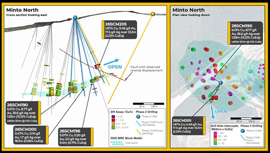
Figure 2: Cross section and plan view of drill holes intersecting the 202 Lens at Minto North. A reverse fault is interpreted to truncate the 202 Lens to the south. Mineralization intersected in 26SCM205 is interpreted as the potential continuation of the 202 Lens in the hangingwall of this fault.
To view an enhanced version of this graphic, please visit:
https://images.newsfilecorp.com/files/11605/310574_068342d484b96990_002full.jpg
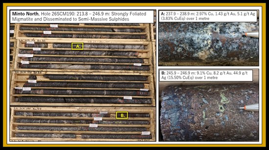
Figure 3: Drill core photographs from Minto North, documenting very high-grade mineralization in the centre of the 202 Lens.
To view an enhanced version of this graphic, please visit:
https://images.newsfilecorp.com/files/11605/310574_068342d484b96990_003full.jpg
Area 118 Drill Results
In Area 118, Phase 2 drilling is targeting expansion and delineation of several mineralized lenses located nearby to existing underground development. During the Phase 1 program, drilling in this area discovered the 301 Lens, a significant new mineralized zone located 200 metres from existing underground development.
Reported here are three drill holes targeting infill and resource expansion at Area 118. All three holes intersected mineralization at depths between 150 and 350 metres below surface. The results confirm the modeled geometry of mineralized lenses in this area and increase the confidence in grade estimation within these lenses.
One drill hole reported here, 26SCM188, intersected significant mineralization in a step-out 50m beyond the limits of previous drilling in this area. This hole intersected a thick interval of migmatite with tightly folded and strongly foliated textures, containing disseminated and folioform bornite and chalcopyrite mineralization. This hole intersected a mineralized intercept consisting of 3.39% Cu, 0.61 g/t Au, and 16.5 g/t Ag (3.73% CuEq) over 6.0 m, within a broader interval 1.66% CuEq over 23.0 metres. The foliated textures and mineralization assemblage observed in this hole are analogous to other well-mineralized lenses within the deposit area, however the thickness and grade intersected in this hole is better than expected. Mineralization in this area remains open to the southwest and is a target for future exploration.
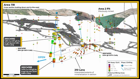
Figure 4: Cross section view of Area 118, looking down and to the northwest. Drill results reported here, including 26SCM188, indicates mineralization in this area remains open to the southwest near historical mining areas.
To view an enhanced version of this graphic, please visit:
https://images.newsfilecorp.com/files/11605/310574_068342d484b96990_004full.jpg
117 Lens Drill Results
In the Minto Main area, follow-up drilling on the 117 Lens is a priority objective of the Phase 2 drill program. This target, discovered during the Phase 1 Drill program, is located close to existing underground mining infrastructure. Reported here are four holes targeting infill and expansion of the 117 Lens. All four of these holes intersected significant mineralization, with grade and thickness that is generally consistent with the 2026 mineral resource estimation in this location.
Drill hole 26SCM179 was designed to test the western extents of known mineralization at the 117 Lens, with a step-out of 30 metres beyond previous drilling in this location. This hole intersected 0.98% Cu, 0.39 g/t Au and 3.4 g/t Ag (1.25% CuEq) over 12.7m. Results of this drilling indicate that mineralization associated with the 117 Lens remains open to the west. The team is evaluating additional drilling during the Phase 2 program to follow-up on these results.
Copper Keel Drill Results
At Copper Keel, Phase 2 drilling is targeting infill and expansion of several shallowly dipping mineralized lenses. Reported here are eight drill holes targeting infill of the eastern portion Copper Keel resource area. Seven of these holes intersected notable copper-gold-silver mineralization, increasing confidence in the geological model. However, assay grades in these holes were variable and somewhat lower than expected, ranging from 1.67% CuEq in hole 26SCM187 to 0.66% CuEq in hole 26SCM193. The results of this drilling confirm the continuity of the geological model at Copper Keel but also indicate limited potential for additional resource expansion within this area.
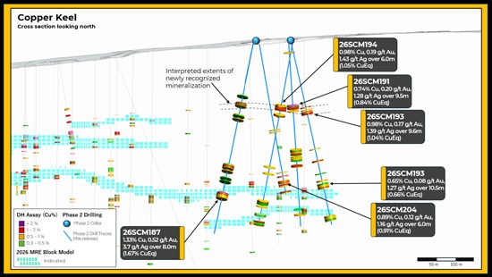
Figure 5: Cross section view of Copper Keel, looking to the north. Infill drilling confirms continuity of modelled mineralized lenses, as well as identifying newly recognized mineralization in the upper portion of several holes.
To view an enhanced version of this graphic, please visit:
https://images.newsfilecorp.com/files/11605/310574_068342d484b96990_005full.jpg
Table 2: Collar Locations and Header Information
| Hole ID | Easting | Northing | Azi | Dip | EOH (m) | Zones | Category |
| 26SCM179 | 384724 | 6944714 | 250.9 | -77.1 | 340 | 117 Lens | Expansion |
| 26SCM182 | 385849 | 6943626 | 313 | -73 | 225 | Copper Keel | Infill |
| 26SCM184 | 384724 | 6944714 | 182 | -87.5 | 354 | Minto Main | Infill |
| 26SCM185 | 385850 | 6943626 | 326 | -83 | 216 | Copper Keel | Infill |
| 26SCM187 | 385850 | 6943624 | 263 | -70 | 245 | Copper Keel | Infill |
| 26SCM188 | 384853 | 6944153 | 185 | -85 | 357 | Area 118 | Expansion |
| 26SCM189 | 384724 | 6944714 | 102.5 | -69 | 399 | Minto Main | Infill |
| 26SCM190 | 384008 | 6945917 | 298 | -80.5 | 264 | Minto North | Infill |
| 26SCM191 | 385841 | 6943565 | 82 | -81 | 225 | Copper Keel | Infill |
| 26SCM192 | 384852 | 6944157 | 110 | -81 | 330 | Area 118 | Infill |
| 26SCM193 | 385841 | 6943561 | 138 | -77 | 225 | Copper Keel | Infill |
| 26SCM194 | 385843 | 6943559 | 5 | -76 | 234 | Copper Keel | Infill |
| 26SCM195 | 384697 | 6944581 | 212 | -75 | 330 | Minto Main | Infill |
| 26SCM196 | 384007 | 6945912 | 219.5 | -71.5 | 276 | Minto North | Infill |
| 26SCM197 | 385795 | 6943565 | 283 | -71 | 135 | Copper Keel | Infill |
| 26SCM198 | 384946 | 6944256 | 110 | -54 | 279 | Area 118 | Infill |
| 26SCM200 | 384008 | 6945912 | 209 | -82.5 | 261 | Minto North | Infill |
| 26SCM202 | 384950 | 6944260 | 97 | -80 | 279 | Area 118 | Infill |
| 26SCM204 | 385793 | 6943571 | 128 | -80 | 180 | Copper Keel | Infill |
| 26SCM205 | 384008 | 6945911 | 204 | -64 | 237 | Minto North | Infill |
| Coordinate System used for Drill Collar Easting and Northing is NAD 83 UTM Zone 8N. |
Table 3: Significant Interval Table
| Hole ID | From | To | Length (m) | Cu % | Au g/t | Ag g/t | CuEq % | Zone | Category |
| 26SCM179 | 315.2 | 327.9 | 12.7 | 0.98 | 0.39 | 3.4 | 1.25 | Minto Main | Expansion |
| 26SCM182 | 90.0 | 101.0 | 11.0 | 0.51 | 0.13 | 0.9 | 0.57 | Copper Keel | Infill |
| 26SCM184 | 307.0 | 336.8 | 29.8 | 0.87 | 0.28 | 2.9 | 1.05 | Minto Main | Infill |
| 26SCM185 | 91.4 | 101.0 | 9.6 | 0.52 | 0.13 | 1.0 | 0.59 | Copper Keel | Infill |
| 26SCM187 | 193.0 | 201.0 | 8.0 | 1.33 | 0.52 | 3.7 | 1.67 | Copper Keel | Infill |
| 26SCM188 | 301.0 | 324.0 | 23.0 | 1.47 | 0.33 | 6.4 | 1.66 | Area 118 | Expansion |
| incl. | 318.0 | 324.0 | 6.0 | 3.39 | 0.61 | 16.5 | 3.73 | Area 118 | Expansion |
| 26SCM189 | 282.3 | 298.9 | 16.6 | 0.70 | 0.26 | 2.2 | 0.86 | Minto Main | Infill |
| incl. | 282.3 | 290.0 | 7.7 | 0.99 | 0.36 | 2.7 | 1.21 | Minto Main | Infill |
| 26SCM190 | 213.8 | 246.9 | 33.2 | 0.88 | 0.78 | 4.6 | 1.49 | Minto North | Infill |
| incl. | 238.0 | 246.9 | 9.0 | 1.69 | 2.11 | 10.1 | 3.40 | Minto North | Infill |
| 26SCM191 | 79.3 | 88.9 | 9.6 | 0.74 | 0.20 | 1.3 | 0.84 | Copper Keel | Infill |
| 26SCM192 | 204.9 | 210.7 | 5.8 | 1.26 | 0.37 | 5.2 | 1.50 | Area 118 | Infill |
| 26SCM193 | 82.3 | 91.9 | 9.6 | 0.98 | 0.17 | 1.4 | 1.04 | Copper Keel | Infill |
| 26SCM194 | 81.0 | 94.7 | 13.7 | 0.75 | 0.15 | 1.1 | 0.81 | Copper Keel | Infill |
| 26SCM195 | 79.1 | 84.9 | 5.8 | 0.93 | 0.21 | 3.7 | 1.05 | Minto Main | Infill |
| 26SCM196 | 211.5 | 220.9 | 9.4 | 0.57 | 0.20 | 2.0 | 0.71 | Minto North | Infill |
| and | 242.6 | 244.7 | 2.1 | 2.03 | 1.10 | 9.4 | 2.84 | Minto North | Infill |
| 26SCM197 | No significant intercept | Copper Keel | Infill |
| 26SCM200 | 216.4 | 234.9 | 18.5 | 0.47 | 0.14 | 1.7 | 0.56 | Minto North | Infill |
| 26SCM202 | 223.0 | 231.5 | 8.5 | 0.72 | 0.35 | 3.2 | 0.97 | Area 118 | Infill |
| 26SCM204 | 158.2 | 169.4 | 11.2 | 0.89 | 0.12 | 1.2 | 0.91 | Copper Keel | Infill |
| 26SCM205 | 168.8 | 182.0 | 13.3 | 1.87 | 0.46 | 17.5 | 2.25 | Minto North | Expansion |
| incl. | 173.5 | 177.2 | 3.7 | 3.43 | 0.36 | 47.0 | 3.87 | Minto North | Expansion |
| and | 209.7 | 214.3 | 4.7 | 1.85 | 0.86 | 12.1 | 2.50 | Minto North | Infill |
CuEq Calculation:
CuEq = ((Cu% × CuP × RCu × 2204.62)+(Au g/t ÷ 31.1035 × AuP × RAu) + (Ag g/t ÷ 31.1035 × AgP × RAg ))/(CuP × RCu × 2204.62)
Where:
CuP/AuP/AgP = USD$ commodity prices of $4.60/lb Cu, $3,300/oz Au, $40/oz Ag; RCu = Cu Recovery = 90%; RAu = Au Recovery = 80%; RAg= Ag Recovery = 80%
Recoveries as estimated from historical mineral processing results. |
QAQC Procedures and Data Validation
The Company is drilling NQ-diameter core and completing geological logging and oriented core structural data collection. Following data collection, core is cut along the long axis, with half of the core going to the lab for chemical analysis and the remaining half kept in sequence as record. The half core samples are packaged with the corresponding sample tag id and sealed. All sampling is conducted by Selkirk Copper and is subject to Company standard internal quality control and quality assurance (QAQC) programs. QAQC procedures include the insertion of certified reference material, coarse blank materials, and field duplicate analysis, as well as standard laboratory procedures to monitor contamination during preparation, analytical accuracy, and precision. QAQC insertion rates by Selkirk Copper approximate 15% of all samples at set intervals.
For the Phase 2 drill program, all samples were sent to ALS's prep facility in Whitehorse, then shipped to ALS's analytical laboratory in Vancouver. All samples are prepared by crushing rock to 70% passing 2mm screen, then splitting a 250g sub-sample using a riffle splitter before being pulverized 85% passing 75 microns. Gold is analyzed by 30 g Fire Assay (Au-AA23) with atomic absorption (AAS) analysis followed by gravimetric finish for overlimit results. Copper is analyzed by four-acid digest (ME-ICP61) with inductivity coupled plasma - atomic emission spectroscopy (ICP-AES) finish. If copper overlimit results are triggered a second four-acid digest for high grade copper (Cu-OG62) is conducted. Samples containing greater than 1000 ppm copper are also analyzed for soluble copper using a sulphuric acid leach (Cu-AA05) analysis with AAS finish is performed. ALS Vancouver holds an ISO/IEC 17025 standard accreditation.
QAQC results are reviewed by Selkirk Copper upon receipt of assay results. Overall, QAQC results show strong analytical performance across Cu, Au, and Ag datasets. All control standards are within acceptable tolerance, with no significant outliers or systematic bias observed.
Primary intervals are reported as drill core length, with true widths estimated to be approximately 90% of core lengths, based on the sub-horizontal to shallow-dipping nature of the modelled mineralized zones.
Mineral Resource Estimate Details
The following table summarizes the current Minto Mineral Resource Estimate:
Table 4: Global Mineral Resource Estimate for the Minto Project (Effective Date: June 10, 2026)
| Type | Cut | Class | ROM | In Situ Grade | Metal |
| (CDN$) | Tonnage (000) | NSR (CDN$) | Cu (%) | Au (gpt) | Ag (gpt) | Ox Ratio | ASCu (%) | Cu (Mlbs) | Au (Koz) | Ag (Koz) |
| OP | $30 | Indicated | 21,779 | $80.63 | 0.59 | 0.17 | 1.8 | 0.11 | 0.073 | 283 | 122 | 1,294 |
| Inferred | 7,052 | $74.61 | 0.55 | 0.13 | 1.6 | 0.08 | 0.048 | 85 | 30 | 354 |
| UG | $80 | Measured | 348 | $153.47 | 0.92 | 0.39 | 3.3 | 0.05 | 0.041 | 7 | 4 | 36 |
| Indicated | 25,679 | $189.20 | 1.15 | 0.49 | 4.4 | 0.06 | 0.067 | 650 | 404 | 3,638 |
| Inferred | 9,812 | $146.57 | 0.91 | 0.36 | 3.5 | 0.05 | 0.044 | 196 | 112 | 1,113 |
| Total | Varies as Above | Measured + Indicated | 47,806 | $139.48 | 0.89 | 0.34 | 3.2 | 0.08 | 0.070 | 940 | 530 | 4,969 |
| Inferred | 16,865 | $116.48 | 0.76 | 0.26 | 2.7 | 0.06 | 0.046 | 281 | 142 | 1,467 |
| Notes | - The MRE has been completed by Sue Bird of Moose Mountain Technical Services (MMTS).
- The effective date of the resource is June 10, 2026
- Resources are reported using the 2014 CIM Definition Standards and were estimated using the 2019 CIM Best Practices Guidelines.
- For the Net Smelter Proceeds (NSP) calculations:
- Metal prices are USD$4.60lb Cu, USD$3,300/oz Au, USD$40/oz Ag;
- A currency exchange rate of 0.72 US$ per CAD$;
- 97.5% payable Cu, 98% payable Au and 92% payable Ag; and the following inputs:
- Concentrate grade of 38% Cu with a moisture content of 8%;
- Unit deductions of 1gpt Au, 30gpt Ag;
- Offsite costs (refining, transport and insurance) of US$200/dmt;
- Treatment for Cu Charges of USD$35, Refining Charges of USD$0.035/lb payable Cu, USD$5.00/oz Au and USD$0.50/oz Ag;
- Royalties of 1.5% NSR.
- Recoveries are as follows:
- CuRecov = 95.5%+1.07*Cu%-113*(ASCu/Total Copper), with a maximum of 98%
- AuRecov = 35.63+0.58032*Curecov-1.3341*Cu%^ 0.8932, with a maximum of 85%
- AgRecov = 69.4+1.9*Aggpt, to a maximum of 85%
- These inputs result in the following NSR and CuEq equations:
- NSR = CAD$CuNSP*CuRecov*Cu%*22.0462 + CAD$AuNSP*AuRecov*Augpt + CAD$AgNSP*AgRecov*Aggpt)/31.10348
- CuEq = NSR/(CuNSP*CuRecov*22.0462)
- The Mineral Resource has been confined by a "reasonable prospects of eventual economic extraction" pit or underground shape using the 130% base case NSR for the Ridgetop and Area 118 open pits and by confining shapes for the underground.
- Mining costs are CAD$4.58/tonne for open pit, marginal mining costs of CAD$50/tonne for underground, Processing costs are CAD$30/tonne milled, and G&A costs are CAD$20/tonne milled.
- Pit slope angles are assumed at 45º.
- The specific gravity of the deposit has been assigned based on domain as between 2.578 and 2.842 based on sg measurements in the Minto deposit.
- Oxide Ratio = ASCu / Total Copper
- Numbers may not add due to rounding.
- OP denotes Open Pit; UG denotes Underground
|
Technical aspects of this news release have been reviewed, verified and approved by Leif Bailey, P.Geo., Director of Geoscience & Exploration of Selkirk Copper Mines Inc., who is a qualified person as defined by National Instrument 43-101 - Standards of Disclosure for Mineral Projects.
About Selkirk First Nation
Selkirk First Nation is centered in Pelly Crossing, a community in central Yukon, 280 km north of Whitehorse. They are a self-governing First Nation, having signed its Final and Self-Government Agreements in 1997. Selkirk First Nation owns 4,740 square kilometers of Settlement Land, including 2,408 square kilometers where they own both the surface and subsurface. Selkirk First Nation is one of three self-governing Northern Tutchone First Nations in the Yukon. The Selkirk First Nation, indirectly, holds a controlling equity stake in Selkirk Copper.
About Selkirk Copper
Selkirk Copper is a well-financed, newly formed company with a controlling interest held by the Selkirk First Nation through its wholly owned subsidiary, that, in partnership with the Selkirk First Nation, is completing a thorough exploration drilling campaign and a restart and redevelopment plan for the former Minto copper-gold-silver mine based on best-in-class environmentally sustainable mining, development and reclamation practice. Selkirk Copper controls 26,850 hectares of prospective mineral claims located in the Minto-Carmacks copper belt as well as significant open-pit and underground infrastructure, a 4,100 tonne per day processing plant, 400-person full-rotation camp, water treatment facilities, numerous ancillary buildings, and mobile equipment centered on the former Minto copper-gold-silver mine. Selkirk Copper's mineral tenure, operation infrastructure, access roads and powerline, is located on or adjacent to Lands of the Selkirk First Nation much of which is surrounded by prospective Selkirk First Nation Category A Lands.
Selkirk Copper Mines Inc. is listed on the TSX Venture Exchange under the symbol (TSXV: SCMI), has a secondary listing on the Frankfurt Exchange under the symbol FRA:IO20, and its common shares trade under the symbol (OTCQX: SKRKF) on the OTCQX® Best Market, a U.S. marketplace operated by OTC Markets Group Inc.
On behalf of the Board of Directors of Selkirk Copper Mines Inc.
M. Colin Joudrie
President and Chief Executive Officer
Neither the TSX Venture Exchange nor its Regulation Services Provider (as that term is defined in the policies of the TSX Venture Exchange) accepts responsibility for the adequacy or accuracy of this release.
CAUTIONARY STATEMENT REGARDING FORWARD-LOOKING INFORMATION
Except for the statements of historical fact, this news release contains "forward-looking information" within the meaning of applicable Canadian securities legislation. When used in this news release, the words "estimate", "project", "belief", "anticipate", "intend", "expect", "plan", "predict", "may" or "should" and the negative of these words, or variations thereon or comparable terminology are intended to identify forward-looking statements and information. The forward-looking statements and information in this news release include information relating to: the use of the MRE for the development of an updated PEA; potential for improvement in quality of the Company's mine plans; development of an updated mine plan and targeted mine life; the remainder of the Company's drill program and integrating results into ongoing studies results and the support of a feasibility study and the timing thereof; the filing of the Technical Report and timing thereof; technical and economic factors that may influence prospects of economic extraction; the business plans and objectives of the Company; and future planned drilling and feasibility study work. Such forward-looking information is based on the Company's expectations, estimates and projections as at the date of this news release.
By their nature, forward-looking statement involve known and unknown risks, uncertainties and other factors, which may cause actual result, performance or achievements to differ materially from those expressed or implied by such statements, including but not limited to: the potential inability of the Company to continue as a going concern, risks associated with potential governmental and/or regulatory action with respect to the Company's operations, the potential inability of the Company to implement its business plan going forward, including but not limited to completing the remainder of the Company's drill program, completing the PEA and Technical Report, and the development of an update mine plan and targeted mine life. Such statements and information reflect the current view of the Company and are based on information currently available to the Company. In connection with the forward-looking information contained in this news release, the Company has made assumptions about the Company's ability to execute on its business plans. The Company has also assumed that no significant events will occur outside the Company's normal course of business. Although the Company believes that the assumptions inherent in the forward-looking information are reasonable, forward-looking information is not a guarantee of future performance and accordingly undue reliance should not be put on such information due to the inherent uncertainty therein.
Any forward-looking information speaks only as of the date on which it is made and, except as may be required by applicable securities laws, the Company disclaims any intent or obligation to update any forward-looking information, whether as a result of new information, future events or results or otherwise.
To view the source version of this press release, please visit https://www.newsfilecorp.com/release/310574

© 2026 Canjex Publishing Ltd. All rights reserved.