Highlights
- Drilling at Minto North continues to delineate high-grade mineralization, which remains open to the north and south:
- 2.26% Cu, 2.23 g/t Au and 10.39 g/t Ag (4.0% CuEq) over 8.1 m, within a broader zone of 1.33% Cu, 0.97 g/t Au and 5.48 g/t Ag (2.1% CuEq) over 29.7 m from 197 m in drill hole 25SCM080.
- Drilling at Minto East intersected multiple stacked mineralized lenses in a 90 m step-out from previous drilling, and remains open for further expansion in east, west and north directions: The deepest mineralization intersected returned notable high-grade copper, gold and silver grades:
- 2.45% Cu, 1.18 g/t Au, and 8.44 g/t Ag (3.4% CuEq) over 5.8 m, from 484 m in drill hole 25SCM082.
- At the Ridgetop and 118 zones, where shallow mineralization supports potential open pit development, drilling continues to expand mineralization beyond previously defined limits:
- At Ridgetop, 0.64% Cu, 0.24 g/t Au, and 2.62 g/t Ag (0.84% CuEq) over 30.4 m, from 38 m depth, in drill hole 25SCM065.
- At Area 118, 0.76% Cu, 0.42 g/t Au, and 3.56 g/t Ag (1.15 % CuEq) over 29.7 m, from 212 m depth in drill hole 25SCM057.
Vancouver, British Columbia and Pelly Crossing, Yukon--(Newsfile Corp. - March 25, 2026) - Selkirk Copper Mines Inc. (TSXV: SCMI) (FSE: IO20) (OTCQB: SKRKF) ("Selkirk Copper" or the "Company") is pleased to announce new assay results from the on going 50,000 m drill program at the Minto Mine in Yukon, Canada.
M. Colin Joudrie, President & CEO, commented: "As we near completion of the planned 50,000 m Phase 1 drill program, and we continue to advance engineering trade off studies, the restart plan is getting better defined. The current phase of drilling is continuing to define and expand zones of high-grade mineralization at Minto North and step-out drilling at Minto East has confirmed the presence of multiple stacked lenses and demonstrates continuity beyond previously drilled areas which is further defining underground development plans. Additionally, results from Ridgetop and Area 118 are extending mineralization within and beyond the current open pit configurations, supporting the potential for expansion of near-surface resources and further defining open pit development plans. These results are being incorporated into ongoing resource modelling and study work as we advance the Preliminary Economic Assessment (PEA) for the Minto copper-gold-silver mine which is on schedule to be completed by mid-2026."
"I would also like thank Chuck Hennessey for joining the team as Senior Vice President Operations in November 2025. Over the past five months, Chuck has significantly refined our development plans through hands-on assessment of the mill and mining infrastructure at Minto, working with the exploration and engineering teams to bring focus to safety, environment, and pragmatic planning work, and assisting the management team in advancing the restart plan. We wish Chuck all the best in his future endeavours."
2026 Phase 1 Drill Program Update
Four diamond drill rigs are active at the Minto mine as the Phase 1 drill program, which started in August 2025 and is nearing completion. The 50,000 m Phase 1 program is focused on resource expansion, as well as technical data collection to support the upcoming Preliminary Economic Assessment. As of March 20, 48,751 metres of drilling in 164 drill holes have been completed, or 97% of the planned 50,000 metre program. The Phase 1 drill program is expected to be completed before the end of March.
Reported here are assay results from holes drilled in late October to mid-November 2025. Results from approximately 48% of the Phase 1 50,000 m program have now been released. The company expects to continue releasing assay results from the Phase 1 drill program as they are received throughout the first half of 2026.
Table 1: Drilling by Zone
| Zone | Holes completed | Metres drilled | % Samples
Received |
| Minto North | 39 | 12,206 | 23.84% |
| Ridgetop | 68 | 13,940 | 45.14% |
| Minto East | 21 | 10,708 | 14.74% |
| Copper Keel | 10 | 3,475 | 8.22% |
| 118 | 15 | 4984 | 8.06% |
| Minto Main | 11 | 4,973 | 0.0% |
| Total | 164 | 48,751 |
|
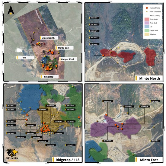
Figure 1: Plan view of the Minto Mine showing surface projections of mineralization zones (Ridgetop (yellow), Copper Keel (green), 118 (blue), Minto East (purple) and Minto North (red)), relative to Phase 1 drill collars (yellow circles). Drill hole results released highlighted in orange circles.
To view an enhanced version of this graphic, please visit:
https://images.newsfilecorp.com/files/11605/289854_featured_holes_multiview_v4_figure%201.jpg
Drill Results
Minto North
Drilling at the Minto North zone continues to delineate the extents of high-grade mineralization in this area, which remains open for expansion in the north and south directions. Reported here are five additional holes from Minto North, all of which returned significant mineralization.
Drilling in this area continues to focus on the Minto North west lens, which is characterized as a zone of intensely foliated and migmatized granodiorite containing disseminated to semi-massive bornite and chalcopyrite mineralization (Figure 2). Magnetite also occurs with the sulphide mineralization, and results in an elevated magnetic susceptibility compared to the surrounding unmineralized rock. The Minto North west lens has been delineated over an area of approximately 315 x 350 m, with a thickness ranging from 5 to 55 metres thick (Figure 3). Preliminary geological modelling indicates that the lens is gently north-dipping, with high-grade mineralization and increased thickness focused along a northwest trend within the lens.
Recent drilling results such as drill hole 25SCM080 demonstrate exceptionally high copper, gold, and silver grades that occur within this lens, including 4.28% Cu, 4.89 g/t Au, and 19.4 g/t Ag (8.1% CuEq) over 1.6 metres within a broader zone of 1.33% Cu, 0.97 g/t Au and 5.48 g/t Ag (2.1% CuEq) over 29.7 m (Figure 2 & 3).
Recent geological logging in this area has also identified a series of northwest-striking faults that divide or offset mineralization within broader the Minto North area. Interpretation is ongoing to identify potential new drill targets using geological, structural, and geophysical datasets.
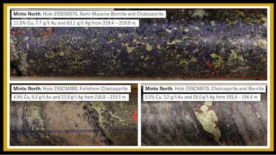
Figure 2: Drill core photographs of high-grade bornite and chalcopyrite mineralization in three drill holes intersecting the Minto north west Lens.
To view an enhanced version of this graphic, please visit:
https://images.newsfilecorp.com/files/11605/289854_minto%20north%20high%20grade_figure%202.jpg
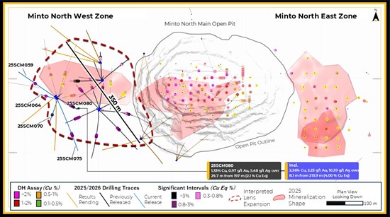
Figure 3: Minto North Plan View Map highlight results from 25SCM080.
To view an enhanced version of this graphic, please visit:
https://images.newsfilecorp.com/files/11605/289854_minto%20north_figure%203.jpg
Minto East
Drilling at Minto East is focused on expanding several stacked mineralized lenses. Reported here are five holes, all of which returned significant mineralization.
Within Minto East, at least five sub-horizontal mineralized domains have been intersected within an area that is approximately 950 x 250 metres wide. Historical drilling has delineated these lenses at depths of 70 to 450 metres below surface. The current drill program has undertaken large step-outs that have expanded the zone of mineralization at Minto East beyond what was previously described. Additionally, recent drilling has intersected mineralization at depths of up to 650 metres below surface, well beyond previous drill depths, indicating potential for delineating additional resources at depth.
Individual lenses within Minto East are broadly similar to each other, consisting of bornite and chalcopyrite mineralization hosted in foliated to migmatized granodiorite. Individual lenses are 5 to 30 metres thick, and continuous along strike for up to 500 meters. Continuity of grade and thickness along lenses is relatively high, and mineralization is open for expansion to the north and to the south.
Drill hole 25SCM082 (Figure 4), reported here, intersected three intervals of significant mineralization at depths of 378, 421, and 484 metres below surface. The deepest interval 484 metres below surface represented a 90 m step-out from the nearest previous drilling, and returned strong grades of 2.45% Cu, 1.18 g/t Au, and 8.44 g/t Ag (3.4% CuEq) over 5.8 m. This mineralization remains open to the east, west, and north, and is a priority target for follow-up drilling.
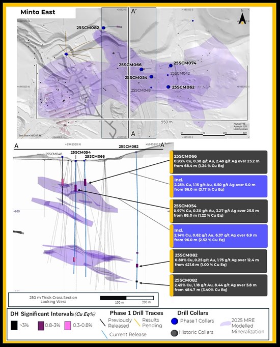
Figure 4: Plan view and cross section of Minto East, showing Phase 1 drilling targeting northern and deep extensions of lenses.
To view an enhanced version of this graphic, please visit:
https://images.newsfilecorp.com/files/11605/289854_minto%20east_figure%204.jpg
Ridgetop and Area 118
Drilling in the southern half of the property is focused on defining the potential open-pit resources at Ridgetop and Area 118 zones. These potential open-pit resources represent an opportunity to delineate relatively large amounts of near-surface tonnage that could be mined at low strip ratio and at a lower cut-off grade. Reported here are 16 holes from Ridgetop (Figure 5) and 5 holes from Area 118 (Figure 6) that were drilled in October and November. Of these 21 drill holes, 19 returned significant intercepts.
At Ridgetop South, the drilling reported here represents a balance of infill holes and a fence of holes stepping-out 50 to 75 metres south and southwest beyond the limits of previous drilling. Mineralization in the southern part of Ridgetop is comprised of a series of three stacked, subhorizontal lenses that occur within 125 metres of surface. Assay results from drilling at Ridgetop reported here vary from 0.5% CuEq to 1.2% CuEq, significantly above the 2025 MRE open pit cut-off grade of 0.30% CuEq.
At Area 118, the drilling reported here represents a fence of holes stepping-out 40 to 100 metres southeast, testing the continuity of a series of high-grade intercepts from historical drilling that sit outside the 2025 MRE modelled mineralization. Mineralization in this area comprises at least two stacked lenses that occur within 150 metres of surface. Assay results reported from Area 118 reported here vary from 0.45% CuEq to 0.65% CuEq, above the 2025 MRE open pit cut-off grade of 0.30% CuEq.
Also, within Area 118, drill hole 25SCM057 intersected additional, unexpected, mineralization at depth beneath the known lenses. This intersection, comprising 0.76% Cu, 0.42 g/t Au, and 3.56 g/t Ag (1.15 % CuEq) over 29.7 metres, represents a new mineralized lens that was not previously recognized (Figure 6). Building on this discovery, additional drilling has been incorporated into the Phase 1 drilling program to target expansion of this newly recognized mineralized lens at depth within Area 118.
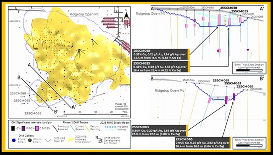
Figure 5: Plan view and Cross section view of the Ridgetop drilling
To view an enhanced version of this graphic, please visit:
https://images.newsfilecorp.com/files/11605/289854_ridgetop_figure%205.jpg
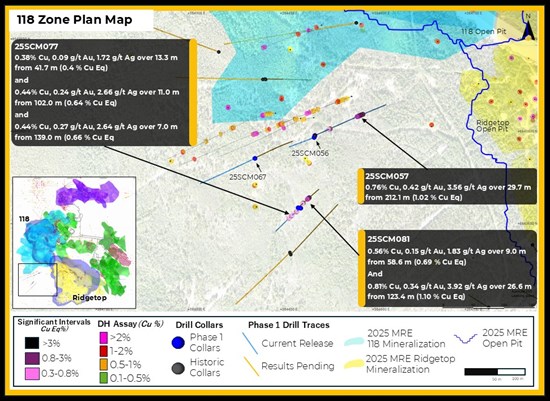
Figure 6: Plan Map of the 118 south zone including expansion drilling from Phase 1
To view an enhanced version of this graphic, please visit:
https://images.newsfilecorp.com/files/11605/289854_118_figure%206.jpg
The location, azimuth, dip and depth of hole of this new drilling is summarized in Table 2 and significant intervals are summarized in Table 3.
Table 2: Collar Locations and Header Information
| Hole ID | Easting | Northing | Azi | Dip | EOH (m) | Zones |
| 25SCM041 | 384917 | 6943579 | 0 | -90 | 104 | Ridgetop |
| 25SCM047 | 385006 | 6943515 | 0 | -90 | 165.16 | Ridgetop |
| 25SCM049 | 385809 | 6943730 | 0 | -90 | 258 | Copper Keel |
| 25SCM050 | 385810 | 6943730 | 90 | -65 | 207 | Copper Keel |
| 25SCM051 | 384991 | 6943488 | 0 | -90 | 165 | Ridgetop |
| 25SCM053 | 384995 | 6943425 | 0 | -90 | 168 | RT South |
| 25SCM054 | 385359 | 6945040 | 0 | -90 | 420 | Minto East |
| 25SCM055 | 385029 | 6943455 | 0 | -90 | 165 | Ridgetop |
| 25SCM056 | 384506 | 6943786 | 245 | -70 | 125 | Area 118 |
| 25SCM057 | 384507 | 6943789 | 65 | -70 | 354 | Area 118 |
| 25SCM058 | 384973 | 6943458 | 0 | -90 | 180 | Ridgetop |
| 25SCM059 | 383888 | 6945945 | 305 | -63.5 | 291 | Minto North |
| 25SCM060 | 384938 | 6943509 | 0 | -90 | 189 | Ridgetop |
| 25SCM061 | 384889 | 6943455 | 285 | -75 | 177 | Ridgetop |
| 25SCM062 | 385434 | 6944994 | 0 | -90 | 177 | Minto East |
| 25SCM063 | 384848 | 6943410 | 315 | -70 | 180 | Ridgetop |
| 25SCM064 | 383887 | 6945943 | 284 | -80 | 246 | Minto North |
| 25SCM065 | 384879 | 6943373 | 0 | -90 | 138 | Ridgetop |
| 25SCM066 | 385317 | 6945072 | 60 | -85 | 435 | Minto East |
| 25SCM067 | 384409 | 6943752 | 245 | -70 | 261 | Area 118 |
| 25SCM068 | 384919 | 6943371 | 0 | -90 | 165 | Ridgetop |
| 25SCM069 | 385064 | 6943399 | 0 | -90 | 168 | Ridgetop |
| 25SCM070 | 383891 | 6945944 | 198 | -76 | 295.35 | Minto North |
| 25SCM071 | 385030 | 6943403 | 0 | -90 | 102 | Ridgetop |
| 25SCM074 | 384408 | 6943752 | 0 | -90 | 552 | Minto East |
| 25SCM075 | 383891 | 6945944 | 157 | 60.5 | 318 | Minto North |
| 25SCM076 | 384995 | 6943399 | 0 | -90 | 186 | Ridgetop |
| 25SCM077 | 384484 | 6943671 | 230 | -80 | 309 | Area 118 |
| 25SCM078 | 384979 | 6943377 | 0 | -90 | 153 | Ridgetop |
| 25SCM079 | 384961 | 6943393 | 0 | -90 | 207 | Ridgetop |
| 25SCM080 | 383886 | 6945947 | 117 | -77 | 300 | Minto North |
| 25SCM081 | 384480 | 6943672 | 50 | -80 | 288 | Area 118 |
| 25SCM082 | 385143 | 6945265 | 82 | -80 | 515.6 | Minto East |
Table 3: Significant Interval Table
| Hole ID | From | To | Length (m) | Cu % | Au g/t | Ag g/t | CuEq % | Zone |
| 25SCM041 | 49.7 | 64.0 | 14.3 | 0.40 | 0.10 | 1.33 | 0.49 | RT South |
| 25SCM047 | 46.2 | 58.2 | 12.0 | 0.68 | 0.16 | 1.95 | 0.81 | RT South |
| 25SCM049 | No Significant Intercept | Copper Keel |
| 25SCM050 | No Significant Intercept | Copper Keel |
| 25SCM051 | 148.2 | 157.1 | 8.9 | 0.81 | 0.17 | 4.66 | 0.92 | Ridgetop |
| 25SCM053 | 22.4 | 50.8 | 28.4 | 0.49 | 0.08 | 1.35 | 0.52 | RT South |
| 25SCM054 | 88.0 | 113.5 | 25.5 | 0.97 | 0.30 | 3.27 | 1.22 | Minto East |
| Incl. | 96.0 | 102.9 | 6.9 | 2.14 | 0.62 | 6.37 | 2.52 | Minto East |
| 25SCM055 | 40.0 | 46.2 | 6.2 | 0.37 | 0.12 | 1.53 | 0.43 | Minto East |
| 25SCM056 | No Significant Intercept | Area 118 |
| 25SCM057 | 212.1 | 241.8 | 29.7 | 0.76 | 0.42 | 3.56 | 1.02 | Area 118 |
| 25SCM058 | 16.4 | 60.8 | 44.4 | 0.53 | 0.12 | 1.34 | 0.63 | Ridgetop |
| Incl. | 46.0 | 48.9 | 2.9 | 2.21 | 0.32 | 4.53 | 2.49 | Ridgetop |
| 25SCM058 | 147.2 | 161.7 | 14.5 | 0.45 | 0.08 | 2.85 | 0.54 | Ridgetop |
| Incl. | 147.2 | 150.2 | 3.0 | 0.99 | 0.15 | 5.42 | 1.14 | Ridgetop |
| 25SCM059 | 159.0 | 164.8 | 5.8 | 0.76 | 0.39 | 4.34 | 1.09 | Minto North |
| 25SCM060 | 27.1 | 41.3 | 14.2 | 0.50 | 0.06 | 1.20 | 0.55 | Ridgetop |
| 25SCM061 | 66.6 | 82.0 | 15.4 | 0.68 | 0.23 | 3.71 | 0.88 | RT South |
| Incl. | 66.6 | 72.0 | 5.4 | 1.09 | 0.38 | 7.05 | 1.44 | RT South |
| 25SCM062 | 81.7 | 112.7 | 31.0 | 1.30 | 0.54 | 5.81 | 1.76 | Minto East |
| Incl. | 99.0 | 108.0 | 9.0 | 2.01 | 0.72 | 8.64 | 2.62 | Minto East |
| 25SCM063 | 52.0 | 75.0 | 23.0 | 0.60 | 0.20 | 5.65 | 0.80 | RT South |
| 25SCM064 | 163.5 | 170 | 6.50 | 1.14 | 0.83 | 4.82 | 1.80 | Minto North |
| 25SCM065 | 38.0 | 68.4 | 30.4 | 0.64 | 0.24 | 2.62 | 0.84 | RT South |
| Incl. | 45.0 | 49.0 | 4.0 | 1.17 | 0.36 | 4.69 | 1.47 | RT South |
| 25SCM066 | 68.4 | 93.6 | 25.2 | 0.93 | 0.38 | 2.48 | 1.24 | Minto East |
| Incl. | 86.0 | 91.0 | 5.0 | 2.25 | 1.15 | 6.50 | 3.17 | Minto East |
| 25SCM067 | No Significant Intercept | Area 118 |
| 25SCM068 | 21.6 | 49.6 | 28.0 | 0.87 | 0.17 | 2.95 | 1.03 | RT South |
| 25SCM069 | 120.2 | 125.8 | 5.7 | 0.68 | 0.15 | 3.34 | 0.82 | RT South |
| 25SCM070 | 189.8 | 195.6 | 5.8 | 2.37 | 1.67 | 11.05 | 3.71 | Minto East |
| 25SCM071 | 9.0 | 27.9 | 18.9 | 0.58 | 0.05 | 1.24 | 0.62 | Minto North |
| 25SCM074 | 530.5 | 538.4 | 7.9 | 1.79 | 1.24 | 12.27 | 2.82 | Minto East |
| 25SCM075 | 214.7 | 231.0 | 16.3 | 1.25 | 0.58 | 6.07 | 1.74 | Minto North |
| Incl. | 215.7 | 222.3 | 6.6 | 2.36 | 1.17 | 11.52 | 3.33 | Minto North |
| 25SCM076 | 17.1 | 48.0 | 30.9 | 0.45 | 0.05 | 0.95 | 0.49 | Ridgetop |
| 25SCM077 | 41.7 | 55.0 | 13.3 | 0.38 | 0.09 | 1.72 | 0.46 | Area 118 |
| and | 102.0 | 113.0 | 11.0 | 0.44 | 0.24 | 2.66 | 0.64 | Area 118 |
| and | 139.0 | 146.0 | 7.0 | 0.44 | 0.27 | 2.64 | 0.66 | Area 118 |
| 25SCM078 | 16.3 | 51.9 | 35.6 | 0.45 | 0.07 | 1.45 | 0.51 | RT South |
| Incl. | 27.0 | 31.9 | 4.9 | 1.09 | 0.15 | 3.33 | 1.23 | RT South |
| 25SCM079 | 25.0 | 54.0 | 29.0 | 0.54 | 0.12 | 2.07 | 0.65 | RT South |
| and | 128.0 | 146.0 | 18.0 | 0.98 | 0.12 | 4.96 | 1.11 | RT South |
| 25SCM080 | 197.0 | 226.7 | 29.7 | 1.33 | 0.97 | 5.48 | 2.09 | Minto North |
| Incl. | 213.9 | 222.0 | 8.1 | 2.26 | 2.23 | 10.39 | 4.00 | Minto North |
| and | 244.8 | 246.8 | 2.0 | 4.68 | 1.73 | 21.50 | 6.15 | Minto North |
| 25SCM081 | 58.6 | 67.6 | 9.0 | 0.56 | 0.15 | 1.83 | 0.69 | Area 118 |
| and | 123.4 | 150.0 | 26.6 | 0.81 | 0.34 | 3.92 | 1.10 | Area 118 |
| 25SCM082 | 378.1 | 381.6 | 3.5 | 1.17 | 0.20 | 5.44 | 1.37 | Minto East |
| and | 421.6 | 434.0 | 12.4 | 0.80 | 0.25 | 1.75 | 1.00 | Minto East |
| and | 484.7 | 490.5 | 5.8 | 2.45 | 1.18 | 8.44 | 3.40 | Minto East |
| At the Minto North and Minto East zones, the flat laying to shallowly dipping nature of the mineralized zones suggest that true widths are typically >90% of the reported drill intersection length. At Ridgetop and Area 118, true widths are approximate 85-90% of reported drill intersection. lengths. |
CuEq Calculation:
CuEq = ((Cu% × CuP × RCu × 2204.62)+(Au g/t ÷ 31.1035 × AuP × RAu) + (Ag g/t ÷ 31.1035 × AgP × RAg ))/(CuP × RCu × 2204.62)
Where:
CuP/AuP/AgP = US$ commodity prices of $4.25/lb Cu, $2500/oz Au, $29/oz Ag; RCu = Cu Recovery = 98%; RAu = Au Recovery = 85%; RAg= Ag Recovery = 85%
Recoveries as estimated from historical mineral processing results. |
Personnel Update
The Company announces that Mr. Chuck Hennessey has stepped down from his role as Senior Vice President Operations effective March 31, 2026. Mr. Hennessey significantly contributed to and refined our development plans through hands-on assessment of the mill and mining infrastructure at Minto, bringing focus to safety, environment, and pragmatic planning work, and assisting the management team in advancing the restart plan. The Company sincerely thanks Mr. Hennessey for his contributions and wishes him continued success. Selkirk Copper is actively seeking for a suitable individual to join our executive team and contribute to restart development and early operations planning activities.
QAQC Procedures and Data Validation
The Company is drilling NQ sized core. Following data collection, core is cut along the long axis, with half of the core going to the lab for chemical analysis and the remaining half kept in sequence as record. The half core samples are packaged with the corresponding sample tag id and sealed. All sampling is conducted by Selkirk Copper Mines Inc. and subject to Company standard internal quality control and quality assurance (QAQC) programs which include the insertion of certified reference material, coarse blank materials, and field duplicate analysis, on top of the standard laboratory QAQC procedures to monitor contamination during preparation and analytical accuracy and precision. QAQC insertion rates approximate 15% of all samples at set intervals. For the 2025 program all samples were sent to ALS Laboratory's prep laboratory in Whitehorse, YK, then shipped to ALS Vancouver for gold fire assay and four-acid multi-element analysis. All samples are prepared by crushing rock to 70% passing 2mm screen, then splitting a 250g sub-sample using a riffle splitter before being pulverized 85% passing 75 microns. Gold is analyzed by 30 g Fire Assay (Au-AA23) with atomic absorption (AAS) analysis followed by gravimetric finish for overlimit results. Copper is analyzed by four-acid digest (ME-ICP61) with inductivity coupled plasma - atomic emission spectroscopy (ICP-AES) finish. If Cu overlimit results are triggered a second four-acid digest for high grade copper (Cu-OG62) is conducted. For any samples where oxide copper minerals are identified, a sulphuric acid leach (Cu-AA05) analysis with AAS finish is performed. ALS Vancouver holds an ISO/IEC 17025 standard accreditation.
QAQC results are reviewed open receipt of results. Overall QAQC results show strong analytical performance across Cu, Au, and Ag datasets. All control standards are within acceptable tolerance, with no significant outliers or systematic bias observed.
Primary intervals are reported as drill core length, with true widths estimated to be approximately 90% of core lengths, based on the sub-horizontal to shallow dipping nature of the modelled mineralized zones.
Mineral Resource Details
The following table (Table 4) summarizes the current Minto Mineral Resource:
Table 4: Global Mineral Resource Estimate for the Minto Project (Effective Date: April 7, 2025)
| Type | Cut | Class | ROM | In Situ Grade | Metal |
| (CDN$) |
| Tonnage (000) | NSR (CDN$) | Cu (%) | Au (gpt) | Ag (gpt) | Ox Ratio | ASCu (%) | Cu (Mlbs) | Au (Koz) | Ag (Koz) |
| OP | $30 | Indicated | 6,085 | $89.11 | 0.897 | 0.274 | 2.9 | 0.15 | 0.163 | 120.3 | 53.7 | 560.4 |
| Inferred | 9,496 | $73.71 | 0.702 | 0.162 | 2.4 | 0.07 | 0.057 | 146.9 | 49.3 | 738.4 |
| UG | $80 | Indicated | 6,504 | $183.90 | 1.489 | 0.636 | 5.6 | 0.06 | 0.090 | 213.5 | 132.9 | 1,167.6 |
| Inferred | 14,162 | $156.85 | 1.281 | 0.539 | 4.9 | 0.06 | 0.075 | 399.9 | 245.4 | 2,229.6 |
| Total | Varies as Above | Indicated | 12,588 | $138.08 | 1.203 | 0.461 | 4.3 | 0.10 | 0.125 | 333.8 | 186.6 | 1,728.0 |
| Inferred | 23,658 | $123.48 | 1.048 | 0.387 | 3.9 | 0.07 | 0.068 | 546.8 | 294.7 | 2,968.1 |
| Notes | - The MRE has been completed by Sue Bird of Moose Mountain Technical Services (MMTS).
- Resources are reported using the 2014 CIM Definition Standards and were estimated using the 2019 CIM Best Practices Guidelines.
- Mineral Resources that are not Mineral Reserves do not have demonstrated economic viability.
- Metal prices of US$2000/oz Au, US$23/oz Ag, US$4.00lb Cu.
- For the NSR calculations: a currency exchange rate of 0.72 US$ per C$; 95% payable Cu, 88% payable Au and 70% payable Ag; offsite costs (refining, transport and insurance) of US$256.18/dmt; royalties of 1.5% NSR.
- Recoveries are as follows:
- CuRec = 95.5%+1.07*Cu%-113*ASCu/TCu, with a maximum of 98%
- AuRec = 20.99*Augpt + 62.01, with a maximum of 95%
- AgRec = 69.4+1.9*Aggpt, with a maximum of 85%
- These inputs result in the following NSR and CuEq equations respectively:
NSR = C$4.73*CuRec*Cu%*22.0462 + (C$2400.60*AuRec*Augpt + C$21.45*AgRec*Aggpt)/31.10348
CuEq = NSR/(Cu*CuRec*22.0462)
- The Mineral Resource has been confined by a "reasonable prospects of eventual economic extraction" pit or underground shape using the 100% base case NSR for the Ridgetop and Area 118 open pits and by a confining shape for the underground.
- Mining costs are C$4.10/tonne for open pit, C$45.42/tonne for underground, Processing costs are C$30/tonne milled and G&A costs are C$20.81/tonne milled.
- Pit slope angles are assumed at 45º.
- The specific gravity of the deposit has been assigned based on domain as between 2.578 and 2.849 based on sg measurements in the Minto deposit.
- Ox Ratio = ASCu/Total Cu.
- Numbers may not add due to rounding.
- OP denotes Open Pit; UG denotes Underground
|
References
1 See 2025-08-06 Technical Report "NI 43-101 2025 Mineral Resource Estimate Update for the Minto Property, Yukon, Canada" effective date 2025-04-07 filed by Venerable Ventures Ltd., available on SEDAR+ (sedarplus.ca).
Technical aspects of this news release have been reviewed, verified and approved by Stacie Jones-Clark, P.Geo., Vice President Exploration of Selkirk Copper Mines Inc., who is a qualified person as defined by National Instrument 43-101 - Standards of Disclosure for Mineral Projects.
About Selkirk First Nation
Selkirk First Nation is centered in Pelly Crossing, a community in central Yukon, 280km north of Whitehorse. They are a self-governing First Nation, having signed its Final and Self-Government Agreements in 1997. Selkirk owns 4,740 square kilometers of Settlement Land, including 2,408 square kilometers where Selkirk owns both the surface and subsurface. Selkirk First Nation is one of three self-governing Northern Tutchone First Nations in the Yukon. The Selkirk First Nation, indirectly, holds a controlling equity stake in Selkirk Copper.
About Selkirk Copper
Selkirk Copper is a well-financed, newly formed company with a controlling interest held by the Selkirk First Nation through its wholly owned subsidiary, that, in partnership with the Selkirk First Nation, is completing a thorough exploration drilling campaign and a restart and redevelopment plan for the former Minto copper-gold-silver mine based on best-in-class environmentally sustainable mining, development and reclamation practice. Selkirk Copper controls 26,850 hectares of prospective mineral claims located in the Minto-Carmacks copper belt as well as significant open-pit and underground infrastructure, a 4,100 tonne per day processing plant, 400-person full-rotation camp, water treatment facilities, numerous ancillary buildings, and mobile equipment centered on the former Minto copper-gold-silver mine. Selkirk Copper's mineral tenure, operation infrastructure, access roads and powerline, is located on or adjacent to Lands of the Selkirk First Nation much of which is surrounded by prospective Selkirk First Nation Category A Lands.
Selkirk Copper Mines Inc. is listed on the TSX Venture Exchange under the symbol (TSXV: SCMI), has a secondary listing on the Frankfurt Exchange under the symbol (FSE: IO20), and its common shares trade under the symbol (OTCQB: SKRKF) on the OTCQB® Venture Market, a U.S. marketplace operated by OTC Markets Group Inc.
On behalf of the Board of Directors of Selkirk Copper Mines Inc.
Neither the TSX Venture Exchange nor its Regulation Services Provider (as that term is defined in the policies of the TSX Venture Exchange) accepts responsibility for the adequacy or accuracy of this release.
CAUTIONARY STATEMENT REGARDING FORWARD-LOOKING INFORMATION
Except for the statements of historical fact, this news release contains "forward-looking information" within the meaning of applicable Canadian securities legislation. When used in this news release, the words "estimate", "project", "belief", "anticipate", "intend", "expect", "plan", "predict", "may" or "should" and the negative of these words, or variations thereon or comparable terminology are intended to identify forward-looking statements and information. The forward-looking statements and information in this news release include information relating to: the remainder of the Company's drill program and integrating results into ongoing trade-off studies, the business plans and objectives of the Company. Such forward-looking information is based on the Company's expectations, estimates and projections as at the date of this news release.
By their nature, forward-looking statement involve known and unknown risks, uncertainties and other factors, which may cause actual result, performance or achievements to differ materially from those expressed or implied by such statements, including but not limited to: the potential inability of the Company to continue as a going concern, risks associated with potential governmental and/or regulatory action with respect to the Company's operations, the potential inability of the Company to implement its business plan going forward. Such statements and information reflect the current view of the Company and are based on information currently available to the Company. In connection with the forward-looking information contained in this news release, the Company has made assumptions about the Company's ability to execute on its business plans. The Company has also assumed that no significant events will occur outside the Company's normal course of business. Although the Company believes that the assumptions inherent in the forward-looking information are reasonable, forward-looking information is not a guarantee of future performance and accordingly undue reliance should not be put on such information due to the inherent uncertainty therein.
Any forward-looking information speaks only as of the date on which it is made and, except as may be required by applicable securities laws, the Company disclaims any intent or obligation to update any forward-looking information, whether as a result of new information, future events or results or otherwise.
To view the source version of this press release, please visit https://www.newsfilecorp.com/release/289854

© 2026 Canjex Publishing Ltd. All rights reserved.