(via TheNewswire)
Vancouver, British Columbia - TheNewswire - June 8, 2026: Red Canyon Resources Ltd. (“Red Canyon” or the “Company”) (CSE: REDC | OTCQB: REDRF) is pleased to announce that exploration activities, including diamond drilling, have commenced at its 100% owned 1 Osiris copper–gold project located in central British Columbia.
Company Highlights:
The Company plans to drill test a series of priority copper-gold targets within the Osiris project area. The Osiris targets are located approximately 35 km west-southwest of Centerra Gold's Mount Milligan copper-gold mine, and form part of the Company's larger Inzana Project area.
Exploration programs completed in 2025 and 2026 identified several priority zones with the potential to host alkalic copper-gold mineral systems. Induced polarization (IP) geophysical surveys are underway and expected to further refine and enhance previous target modelling.
An approximate 2,500-metre diamond drilling program consisting of up to 8 drill holes has commenced, initially testing multiple areas at the Camp target. Historical drill hole 91-2 at Camp intersected 127.4 m grading 0.18% copper with anomalous gold values. The Company interprets this intercept as potentially representing the peripheral expression of a copper-gold porphyry system.
In addition to the diamond drilling, rotary scout drilling totalling up to 1,500 m is planned to test several covered targets that have not previously been drill tested.
Wendell Zerb, the Chairman and CEO of the Company, commented: “We are excited to drill-test these alkalic copper-gold targets at Osiris. Alkalic copper-gold systems are commonly associated with above-average grades and host numerous economically significant mines in British Columbia and around the world.
The Camp target is the highest priority based on its favourable regional geological and structural setting, complex magnetic signature, the presence of copper-gold mineralization in drill core and at surface and coincident IP chargeability and resistivity anomalies. The planned drilling will follow-up on encouraging historical drill results, including an intercept of 127.4 metres grading 0.18% copper. Based on characteristics observed in other well-documented alkalic copper-gold systems, including the Cadia-Ridgeway mineral district in New South Wales, Australia, we believe this historical intercept may represent a peripheral expression of potentially higher-grade copper-gold mineralization at Camp.
In addition, we have identified several covered target areas exhibiting geophysical signatures similar to those at Camp. An IP geophysical survey is currently underway and is expected to be followed by an initial rotary scout drilling program. Rotary drilling is a cost-effective first-pass exploration method that has been successfully employed in regions with post-mineral cover.”
Red Canyon Projects
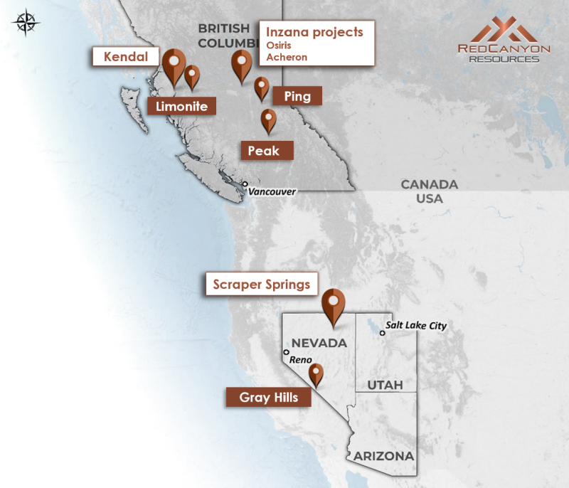
The Company holds a portfolio of seven 100% owned 1 projects in British Columbia and Nevada. High priority projects are Kendal in west-central British Columbia, Inzana (Osiris and Acheron) in central British Columbia and Scraper Springs in northeast Nevada.
Click Image To View Full Size
Figure 1: Location map o f Red Canyon’s 100% owned 1 copper and copper-gold projects.
Osiris Project
The Osiris Project comprises 11 mineral claims which forms the northern part of the Inzana project area. The Inzana project area is located in central British Columbia, approximately 60 km northwest of the district municipality of Fort St. James and 35 km west-southwest of Centerra Gold’s Mount Milligan Cu-Au mine (Figures 1 and 2). The Company staked 14,629 hectares of mineral claims within the Inzana project area that are 100% owned and royalty-free. The Company has also entered into property option agreements to acquire a 100% interest in an additional two mineral claims at Osiris and two mineral claims at Acheron, totalling 539 hectares, for total consideration of $48,000 payable over a three-year term. Each two optioned mineral claims at Osiris and Acheron are subject to a 1.25% net smelter return royalty, of which 100% may be purchased for $2 million at any time.
The project area covers the early Mesozoic-aged Quesnellia island arc terrane that occupies much of east-central British Columbia which hosts several of the province’s largest copper mines . The project area is bounded to the west by the NW-trending Pinchi Fault which juxtaposes older Cache Creek Terrane against Triassic-Jurassic Quesnellia Terrane. The Company interprets that a NE-SW cross-arc structure is located on the northern boundary of the Osiris project area. Cross-arc structures are well documented to be important structural pathways for the localization of porphyry deposits in arc terranes worldwide.
Red Canyon believes the Osiris project has excellent potential to host potentially economic copper-gold porphyry systems and that previous work identified alkalic porphyry alteration and mineralization indicative of peripheral zones to the main porphyry centres. The area hosts various porphyritic intrusive rocks, anomalous copper, molybdenum and gold geochemistry as well as magnetite-rich hydrothermal alteration interpreted to be related to alkalic porphyry copper systems.
Click Image To View Full Size
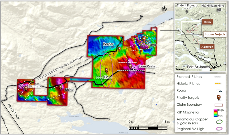
Figure 2: Osiris project, identifying priority targets for 2026 fieldwork, planned IP lines and the Camp target location.
Magnetic data over the Osiris project outlines multiple magnetic features bound to the west by the Pinchi Fault and adjacent to an interpreted cross-arc structure. Forestry activity in the area has significantly improved road access throughout the area.
Red Canyon has completed geological mapping, selective rock, soil and till sample geochemistry, four-acid geochemistry of historic drill core samples, project-wide airborne magnetics and radiometrics and Magnetic Vector Inversion modelling (MVI). Based on these programs, several new targets (Figure 2) have been identified for follow up.
Osiris IP Geophysics
The Company has engaged Scott Geophysics to complete up to 42 line-kilometres of dipole-dipole induced polarization (IP) surveys across multiple target areas (Figure 2). The IP survey is underway and is expected to complement existing target models and geological interpretations. The Company has also engaged Fathom Geophysics to undertake IP inversion modelling and interpretation of the survey results.
Camp Copper-Gold Porphyry Target
The Camp target is associated with a 1.5 km by 2.0 km NNW-trending magnetic high (Figures 2, 3 and 4). Previous work suggests the magnetic high feature may represent highly oxidized alkalic intrusions and associated hydrothermal magnetite .
Click Image To View Full Size
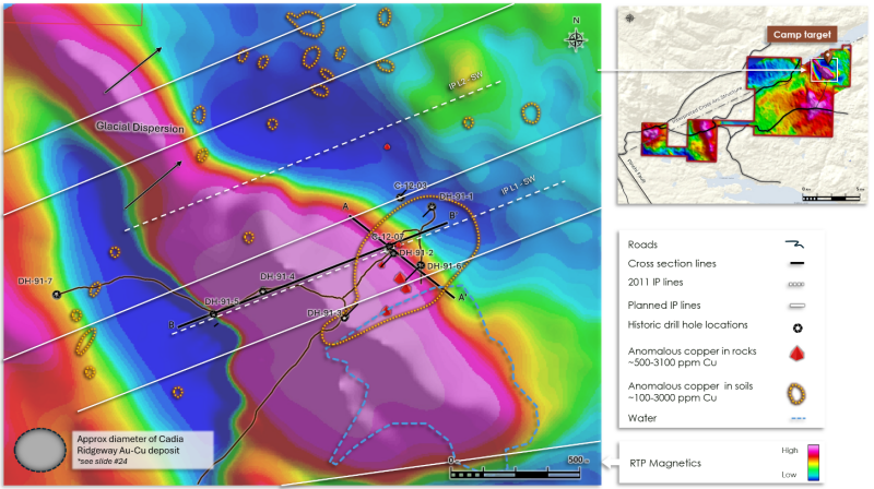
Figure 3: The Camp target highlighted by airborne RTP magnetics, rock and soil geochemistry, historical drill hole locations and for scale the comparative size footprint of Cadia – Ridgeway alkalic Au-Cu deposit .
Click Image To View Full Size
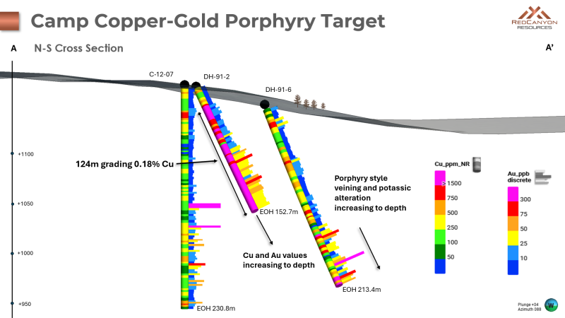
Figure 4: Camp target - NNW – SSE cross-section outlining historical drill holes with Cu and Au histograms.
A series of historical drill holes at Camp (Figures 3, 4 and 6) intersected porphyry-style alteration plus copper and gold mineralization indicative of an alkalic porphyry system. Historical drill holes 91-2 and 91-6 completed by Silver Standard Resources Inc. in 1991 ended in mineralization with grades of copper and gold increasing to depth. In addition, porphyry-style veining and potassic alteration are interpreted to be increasing downhole towards the west (Figure 4).
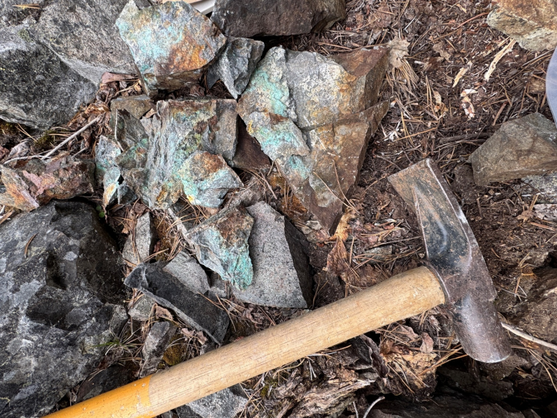
Geological mapping completed by Red Canyon outlined an east-northeast-trending package of hornfels altered sedimentary rocks and interbedded volcanic tuffs that are crosscut by northwest-trending structures parallel to the principal northwest-trending magnetic feature at Camp. Surface mapping identified a southwest-trending zone of copper mineralization preferentially associated with the altered volcanic package. Copper minerals identified include chalcopyrite, malachite and locally occurring bornite.
Click Image To View Full Size
Figure 5: Camp outcrop of altered hornblende porphyry with visible malachite mineralization.
The principal northwest-trending magnetic feature at Camp is interpreted to represent a causative porphyry intrusion that may be responsible for the copper mineralization observed within the adjacent volcanic rocks. Alteration mapping and interpretations derived from historical drill logs suggest increasing alteration temperatures at depth to the west-southwest of historical drill holes 91-2 and 91-6, supporting the potential for a nearby porphyry source.
Historical drill hole 91-2 from Osiris returned 0.18% copper with anomalous gold over 127.4 m starting from 25.3 m down hole. Based on the footprint of other known alkalic porphyry deposits worldwide, the Company believes the target area remains open to vector into a potential higher-grade core to the system.
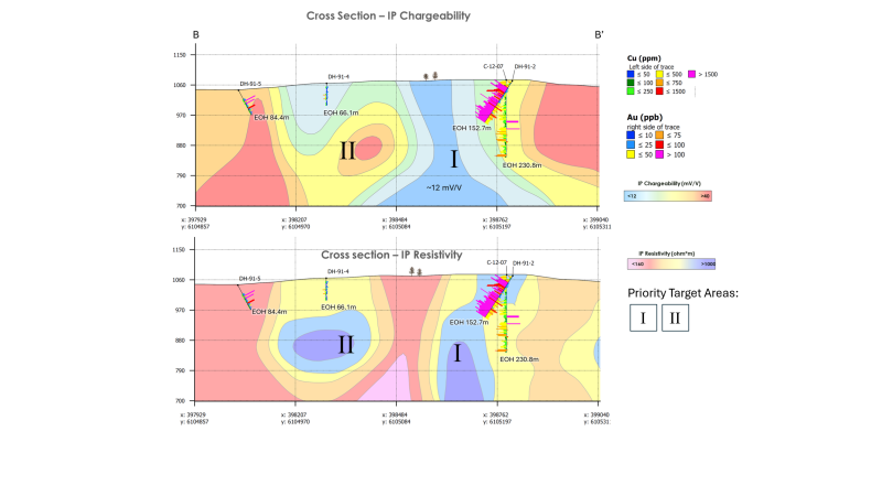
The Company believes the hydrothermal system at Camp remains open along the trend of the magnetic high which extends in a north-northwest to south-southeast direction (Figure 3). Induced polarization (IP) chargeability and resistivity data indicate that zones of elevated chargeability may correlate with altered intrusive rocks and/or graphitic sedimentary units within portions of the Camp area.
A north-trending zone of elevated resistivity, coincident with a moderate chargeability anomaly, is interpreted to represent a potential potassic alteration zone that may correspond to the central portion of the porphyry system (Figure 6).
Click Image To View Full Size
Figure 6: West – East IP chargeability and resistivity cross-section outlining historical drill holes with Cu and Au histograms and priority drill targets . See section line B- B’ Figure 3.
Osiris Magnetic Vector Inversion Modelling
Red Canyon has conducted a project-wide airborne magnetic and radiometric survey, completed by Precision Geosurveys, with Fathom Geophysics completing data filtering and MVI modelling.
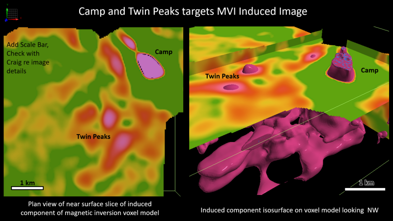
The Camp target is modelled as a highly magnetic body interpreted by the Company to represent a potential altered biotite-feldspar porphyry intrusion. An intrusive halo consists of altered and mineralized porphyritic andesite and/or augite porphyry and is interpreted as a remanent magnetic feature.
The interpreted intrusive complex expands at depth and trends west-southwest, merging with a newly identified covered target area referred to as Twin Peaks (Figure 7). Geophysical modelling indicates the presence of a series of smaller pipe-like bodies, interpreted as possible porphyry intrusions, extending upward from the larger causative intrusion at depth. Selective basal till sampling completed by Red Canyon in 2025 returned broadly anomalous copper and molybdenum geochemistry associated with the Twin Peaks area.
Click Image To View Full Size
Figure 7: Magnetic Vector Inversion (MVI) models for Camp and Twin Peaks.
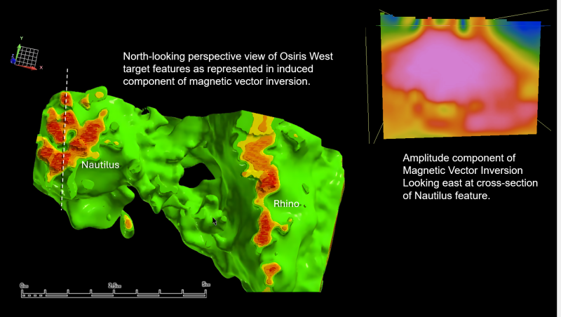
MVI modelling of the Osiris West area has outlined two large-scale, covered, magnetic target zones, Nautilus and Rhino, both of which host significant magnetic features identified by the MVI study.
The Nautilus target is characterized by a circular magnetic feature measuring approximately 3 km by 3 km. The target is bounded to the west by the Pinchi Fault and to the north by an interpreted west-southwest-trending cross-arc structure (Figure 2). MVI modelling identified multiple magnetic pipe-like features interpreted as possible porphyry intrusions emanating from a larger magnetic body at depth, which may represent a potential causative porphyry intrusion (Figure 8).
The Rhino target comprises a north-trending linear magnetic feature measuring approximately 2 km by 5 km. Like Nautilus, the target is bounded to the west by the Pinchi Fault and to the north by the interpreted west-southwest-trending cross-arc structure (Figure 2). MVI modelling identified multiple shallow magnetic pipe-like features interpreted as possible porphyry intrusions connected to a larger magnetic body at depth that may represent a potential causative intrusion. Geophysical modelling also identified potential west-northwest-trending structures linking the Nautilus and Rhino target areas, along which several additional target areas have been identified (Figure 8).
IP geophysical surveys are currently being completed over prominent magnetic features. Following inversion modelling, the Company plans to evaluate the target through an initial rotary drilling program. Follow-up diamond drilling will be assessed based on the results of the IP survey and first-pass rotary drilling program.
Click Image To View Full Size
Figure 8: Magnetic Vector Inversion model of Nautilus and Rhino target areas.
About Red Canyon Resources
Red Canyon Resources Ltd. (CSE: REDC) is a technically driven, discovery-focused mineral exploration company exploring North America’s top copper jurisdictions. The Company’s core goal is to make impactful copper discoveries and has a portfolio of 100% owned copper and copper-gold porphyry exploration projects.
The Kendal copper project in west-central British Columbia remains a priority project for the Company. Current 2026 exploration plans focus on a series of geochemical and geophysical targets identified east of previous drilling at Moly Fork and Kendal Creek. Infill sample geochemistry, IP geophysics and diamond drilling are anticipated to commence in July, 2026.
The Company recently completed a project-scale ZTEM geophysical survey at its 100% owned Scraper Spring project in Nevada. Results, followed by modeling and interpretation, are anticipated in early Q3/2026.
The Company’s technical team consists of experienced geoscientists with diverse capital market, junior and major mining company backgrounds and a track record of success.
For more information, please visit the Company's website at www.redcanyonresources.com .
Red Canyon is part of the NewQuest Capital group which is a discovery-driven investment company that builds value through the incubation and financing of mineral projects and companies. Further information about NewQuest can be found on the company website at www.nqcapitalgroup.com .
1 Red Canyon has two projects subject to option earn in agreements whereby the Company can earn into 100% of the project.
* Source: DISCOVERY OF THE CADIA RIDGEWAY GOLD-COPPER PORPHYRY DEPOSIT - John Holliday, Colin McMillan and Ian Tedder – SMEDG.org.au
On Behalf of the Board of Directors
Wendell Zerb, P. Geol
Chairman and Chief Executive Officer
+1 (604) 681-9100
wzerb@redcanyonresources.com
For further information, please contact:
Brennan Zerb
Investor Relations Manager
+1 (778) 867-5016
bzerb@redcanyonresources.com
The Canadian Securities Exchange does not accept responsibility for the adequacy or accuracy of this press release.
Qualified Person :
The technical information contained in this update has been reviewed and approved by Wendell Zerb, P. Geol, a “Qualified Person” (“QP”) as defined in National Instrument 43-101 – Standards of Disclosure for Mineral Projects. Mr. Zerb is not independent by reason of being the Chairman, President and CEO of the Company. In presenting examples in this release for comparison including the Cadia mine in New South Wales, Australia, the Company in no way implies that future exploration will necessarily result in the discovery of similar economic mineral deposits. *The Qualified Person has not verified the information on theses deposits and the information disclosed is not necessarily indicative of mineralization on Red Canyon projects.
Forward-Looking Statements:
This news release includes certain forward-looking statements and forward-looking information (collectively, “forward-looking statements”) within the meaning of applicable Canadian securities legislation. All statements, other than statements of historical fact, included herein including, without limitation, statements regarding future capital expenditures, exploration activities and the specifications, targets, results, analyses, interpretations, benefits, costs and timing of them, and the anticipated business plans and timing of future activities of the Company, are forward-looking statements. Although the Company believes that such statements are reasonable, it can give no assurance that such expectations will prove to be correct. Often, but not always, forward looking information can be identified by words such as “pro forma”, “plans”, “expects”, “may”, “should”, “budget”, “scheduled”, “estimates”, “forecasts”, “intends”, “anticipates”, “believes”, “potential” or variations of such words including negative variations thereof, and phrases that refer to certain actions, events or results that may, could, would, might or will occur or be taken or achieved. Forward-looking statements involve known and unknown risks, uncertainties and other factors which may cause the actual results, performance or achievements of the Company to differ materially from any future results, performance or achievements expressed or implied by the forward-looking statements. Such risks and other factors include, among others, risks related to the anticipated business plans and timing of future activities of the Company, including the Company’s exploration plans and the proposed expenditures for exploration work thereon, the ability of the Company to obtain sufficient financing to fund its business activities and plans, the ability of the Company to obtain the required permits, changes in laws, regulations and policies affecting mining operations, the Company’s limited operating history, currency fluctuations, title disputes or claims, environmental issues and liabilities, as well as those factors discussed under the heading “Risk Factors” in the Company’s prospectus dated October 12, 2023 and other filings of the Company with the Canadian Securities Authorities, copies of which can be found under the Company’s profile on the SEDAR+ website at www.sedarplus.ca.
Readers are cautioned not to place undue reliance on forward-looking statements. The Company undertakes no obligation to update any of the forward-looking statements, except as otherwise required by law.
Copyright (c) 2026 TheNewswire - All rights reserved.
© 2026 Canjex Publishing Ltd. All rights reserved.