(via TheNewswire)
Vancouver, British Columbia – TheNewswire - January 20, 2026 – Rackla Metals Inc. (TSX-V: RAK) (the “Company”) announces its year-end summary of exploration activities on the Grad Property and other targets in the region and outlines plans for 2026.
Despite extensive drilling in 2025, results did not meet expectations, prompting a detailed review of geochemical data and exploration strategy. This report highlights key findings and priority targets for the upcoming season.
Management of the Company is proud of the team and the program we completed. The technical team, geologists, mountain climbers, pad builders, field crews, diamond drillers, and pilots completed a technically sound program in difficult terrain and in challenging conditions.
One of the big challenges Rackla encountered in 2025 was a slow turn-around time for analytical results, particularly drill sample results which were not received until months after the drill program was completed. This resulted in an inability to adjust the program while crews were in the field.
Grad Program Results
The discovery of the BiTe showing in the fall of 2024 on the southern cliff face of the North Nahanni Pluton (NNP), returned multi-gram gold results with associated anomalous bismuth and tellurium, a geochemical signature typical of a Reduced Intrusion-Related Gold System (RIRGS). These rock grab and channel samples were taken by a number of different geologists on three separate visits to the discovery zone. Each return visit was prompted by the anomalous results of the previous visits. As well, talus-fine sampling along the base of the cliff returned anomalous and consistent gold values over a 550m interval that averaged 1.06 g/t gold. Yet the 2025 drill program consisting of 4500 m in ten holes failed to intersect significant mineralization at depth. The best result from the 2025 drill program was 2.56 g/t gold over 10.5 m in hole G25-009 at the intrusive contact with the sediments. All the holes contained intensely veined intrusive; however, they returned long intervals of below detection limits for gold. These results were far below expectations surprising both the technical team and external analysts.
Upon receipt of all the geochemical and petrographic results a thorough review of the data was completed. The geological staff compiled results from 738 surface rock samples and 3081 drill samples from the work on the Grad property into a specialized geochemistry and geoscience data analysis program (ioGAS) . The program is designed to help geologists detect patterns, anomalies, and relationships in large geochemical datasets. The study incorporated Correlation Matrices, Scatter Plot Matrices, various Metal:Metal ratios, characterization of the intrusion(s) with Immobile Element plots, Discriminate and Ternary plots, Re-clustering, Factor Analysis and Spatial Mapping of the results.
The results from this study showed that the gold mineralization at BiTe is closely correlated with tellurium, bismuth, and antimony. The results also indicate that bismuth to lead ratios (Bi:Pb) could be a useful vector in the search for the geochemical conditions at BiTe elsewhere in the region, as well as the Te:Bi and Bi:Sb ratios.
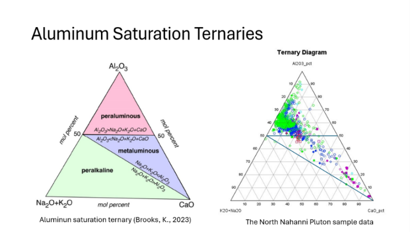
The study also showed that the geochemical conditions that exist at the BiTe showing are distinctly different from that observed in drill core and elsewhere in the NNP. Even the intervals in drill core that showed signs of strong alteration had a different geochemical response than that on surface at BiTe. The analysis indicates that the BiTe zone area is either a different intrusive source or phase of the same intrusion, or an alteration zone that received significant fluid flow associated with a structural trap. Studies show the NNP, in general, is primarily high in aluminum content (peraluminous) while the samples from the BiTe showing tend to be low in aluminum and high in calcium (metaluminous) as illustrated in Figure 1. The intervals in drill core that appeared strongly altered returned a peraluminous signature rather than metaluminous. This difference appears to indicate that the BiTe zone underwent high-temperature, acidic, Ca-rich quartz carbonate alteration.
Figure 1 – Aluminium saturation ternary plot for surface samples collected on the North Nahanni Pluton and in drill core.
Click Image To View Full Size
Legend
Color defines the zone
Purple: BiTe surface samples
Blue: Drill core sample
Green: Surface samples not including BiTe
| Shape defines gold grade
Solid Diamond = >1 ppm
Solid square = 0.5-1 ppm
Open diamond = 0.1 – 0.5 ppm
Open square = 0.05 – 0.1 ppm
Open circle = < 0.05 ppm
|
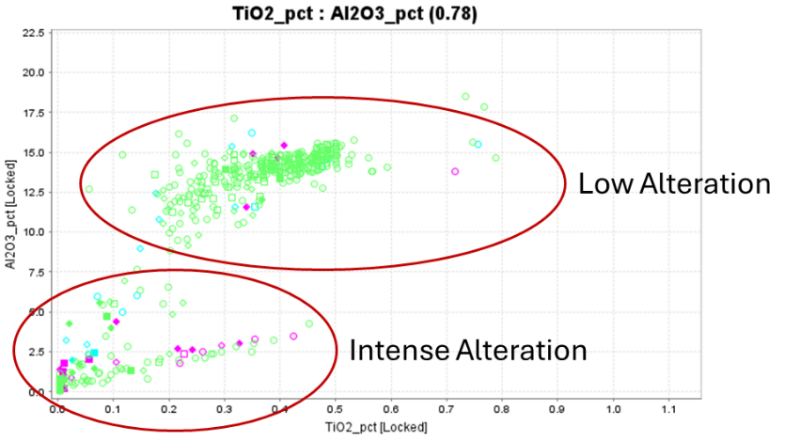
A plot of titanium versus aluminum in Figure 2 also appears to be a useful vector for alteration and can be used as a vector for gold mineralization.
Figure 2 – TiO 2 vs Al 2 O 3 plot for surface samples collected on the North Nahanni Pluton and in drill core defining alteration zonation.
Click Image To View Full Size
These geochemical differences suggest that drilling in 2025 did not test the correct intrusive phase or structural environment responsible for the high‑grade BiTe mineralization. These criteria help to explain the difference in conditions on surface at the BiTe showing compared to those tested by drilling and the sampling conducted on most other areas on the NNP. The study shows that there are other areas with a similar signature to BiTe within the NNP and these need to be mapped and sampled further. These results will guide the 2026 exploration activities at Grad and regionally, and hopefully this data will play a role in a future discovery.
Regional Exploration Targets
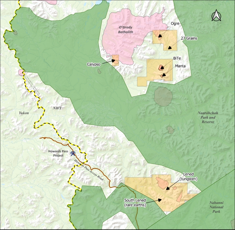
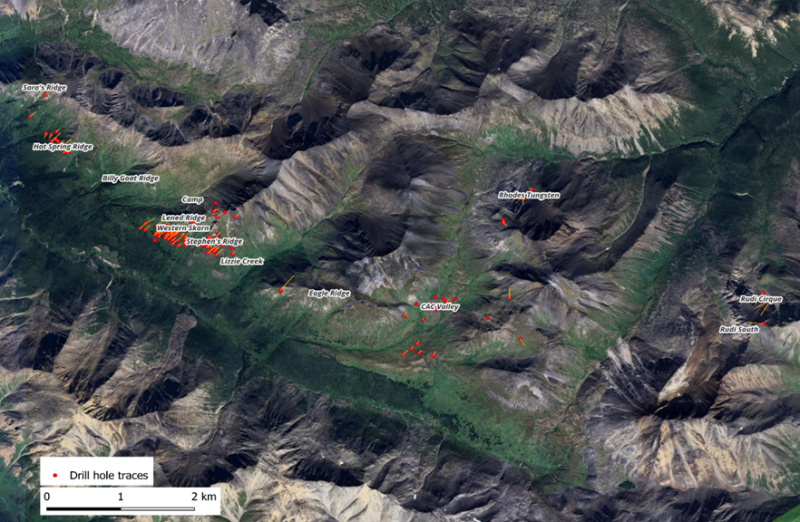
Along with the drill program on the Grad Property, Rackla also conducted regional exploration and identified several interesting targets. This work led to the expansion of the claims on the Ogre property and the staking of the Calypso and Lened properties. Rackla staked an additional twenty-five claims for 26,740 hectares in the region because of these findings.
Figure 3 – Rackla Metals properties and exploration targets in western NWT.
Click Image To View Full Size
Calypso Target
The Calypso property is located 13 km to the west of Grad, on the southwestern tip of the O’Grady Batholith, a large Tombstone Suite intrusion. The initial discovery was made by follow-up of a Regional Geochemical Survey (RGS) stream sediment Au/Bi anomaly. Several narrow, sheeted quartz veins hosted in the granodiorite were observed. Large bismuthinite blebs were observed in quartz veins in a number of samples that returned multi-gram gold results. Talus sampling was conducted and a photogrammetry survey completed. The talus sampling defined an 800 m long anomaly that averaged 0.162 ppm Au. The target area is at an elevation of 1,800m and it is located on a north facing cliff, so it will probably be late July before the Company can enter the area to get any significant mapping done. The plan for 2026 will include detailed geological mapping, additional surface sampling and if warrant drill testing.
Manta Target
Several very high-grade gold-bearing rock grab samples were collected from skarnified sediments with sporadic quartz veining at Manta showing. Late in the season two chip-channel trenches were sampled across the sheeted vein system. The results indicate that, like at Grad, the veining is not necessarily the controlling factor for the gold mineralization. Detailed geological mapping and sampling are planned in 2026 to determine the controls on mineralization and the size potential.
Ogre Target
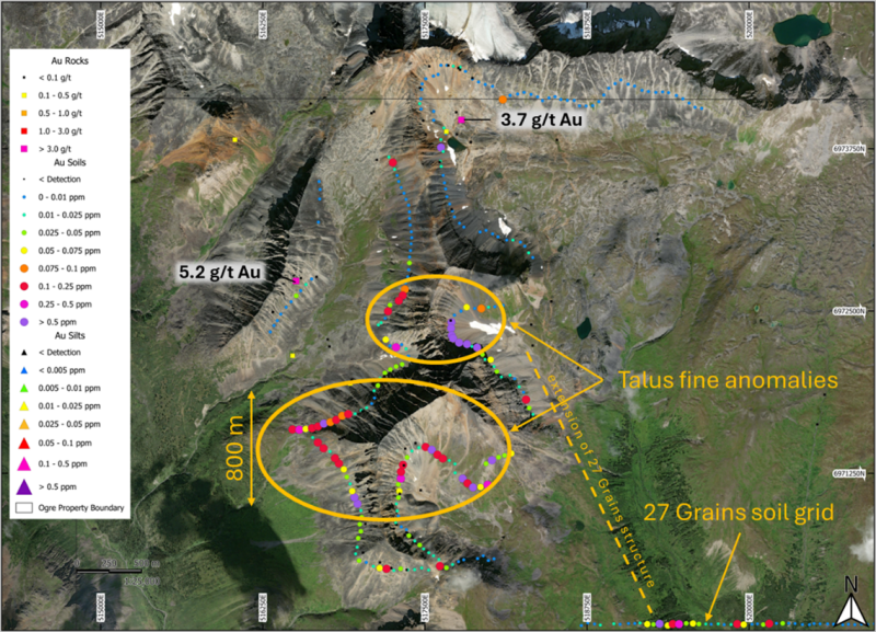
Several sampling days were spent at Ogre and the adjacent 27 Grains target. Although stream and talus geochemistry identified some good anomalies only a few rock samples returned interesting gold numbers and those were mostly from altered sediments with associated high arsenic values.
Figure 4 – Ogre target surface rock and talus-fine sample gold results.
Click Image To View Full Size
The 27 Grains target is the site of a government heavy mineral concentrate (HMC) sample that returned 27 gold grains from panning at a single sample site. Rackla followed it up with panning above and below the site and obtained 1 to 3 “colours” per pan over a 500 m stretch of the creek. A 2.4x2.4 km soil grid was established, and it defined a linear 1.5 km long coincident Au-Bi-As-Te anomaly. The target is underlain by sediments, and there does not appear to be intrusive rocks proximal. This target is looking to be an orogenic, vein-type target. Follow-up work is planned for 2026.
Lened Deposit
During the regional program, Rackla evaluated three Cretaceous intrusions at the historical Lened Tungsten Deposit area for gold potential. One of the stream sediment samples from Lened Creek returned a very strong gold anomally of 6.5 g/t Au. This sample will be followed up in 2026.
While working in the region, Rackla crews found that much of the historic drill core from the work on the tungsten deposit remained on the property and that it appears to be recoverable with box tags and marker blocks in reasonable condition. The Company became aware that deposit was much more advanced that it had previously recognized, that tremendous potential existed and that it was open for staking. The Company immediately staked the deposit.
The history of the Lened Tungsten Deposit dates to discovery in 1960. In 1976, Union Carbide Exploration Corporation purchased the Lened property and from 1977 to 1982 explored the site intensively, advancing the project to pre-feasibility. Their work included detailed geological mapping, a variety of geochemical and geophysical surveys, metallurgical testing, drilling 26,900 m in 178 holes, economic and environmental studies. This work led to the discovery of another fifteen tungsten occurrences over a 15 km strike along the northeastern bank of Lened Creek.
Figure 5 – Lened Tungsten Deposit mineral showings and historical drill hole locations.
Click Image To View Full Size
In 1980, Union Carbide produced the first mineral resource estimate for the project on two of the identified zones, the Western Skarn and Stephens Ridge. That resource which indicated 2.82 million tonnes at a grade of 1.27 WO 3 (not NI 43-101 compliant.) Union Carbide reported the deposit to contain copper and some interesting gold grades up to 1 g/t in selected core samples. There are several zones outside of this resource with high grade tungsten, in places up to 10% W0 3 .
Rackla has been able to acquire the original Union Carbide documents including original drill logs, assay sheets, metalurgical, environmetal, resource, economic studies, mylar maps, geophysical studies and geological mapping, etc. This package is currently being catalogued and scanned. The scanned data will undergo Optical Character Recognition (OCR) using propretary software designed for geological data and the maps will be georeferenced and prepared for import into geological modeling software. The Company expects to have the digital products before the end of January. Once received Rackla will bring the dataset into 3D visualisation software and design an exploration program to bring the resource up to an NI43-101 standard. Field plans for 2026 include recovering, re-logging and re-sampling of the historical core to systematically test for copper, gold and any other metals that might be associated with the tungsten, and testing of the other high-grade showings tungsten showings on the property.
South Lened Rare Earths
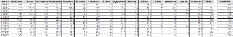
Additionaly, the regional stream sediment sampling program along the Lened Creek returned some very intruiging anomalous rare earth element (REE) results (Table 1). Eleven samples were collected at nominal 200 m intervals covering a 2.4 km stretch of Lened Creek. Researching government stream sediment sample data further, Rackla found that the stream further to the southwest, South Lened Creek, also contained anomalous REE geochemistry. In Yukon and western NWT Government Regional Geochemical Survey (RGS) surveys analyzed for the rare earth elements La, Ce, Sm, Eu, Tb, Yb and Lu as well as the associated elements Y and Sc, the South Lened Creek area returned the highest La, Ce, Sm, Tb and Yb values in all of Yukon and western NWT and was in the top 5 for Eu, Lu, Y and Sc.
Table 1 – Rackla 2025 stream sediment sample rare earth element results from Lened Creek. (all amounts are ppm)
Click Image To View Full Size
Figure 6 – South Lened Rare Earths stream sediment geochemistry rose diagram plot showing relative Ce, La, Pr and Nd values.

Click Image To View Full Size
The smaller tributaries draining from the Lened Tungsten Deposit on the northeast side of Lened Creek into Lened Creek were not anomlaous for REEs, indicating that the source does not appear to be associated with the tungsten mineralization. With anomalies isolated to Lened Creek and South Lened Creek, it would appear that the source is the ridge in between. There is no documented history of exploration on this ridge and, at this point, little is known about the geology of the ridge. Government regional geological mapping shows it as underlain by Neoproterozoic phyllite and clastic sediments. The Company suspects that the phyllite and sediments on the ridge may host an orogenic carbonatite complex and plans to test this theory in 2026.
Historically, much of rare earth element production and supply has come from alluvial placer deposits. Rackla also plans to evaluate the Lened and South Lened creeks for the the possibility of an economic placer occurrence in 2026.
Qualified Person
Scott Casselman, B.Sc., P.Geo., Vice-President Exploration of the Company, is a member of the Association of Professional Engineers and Geoscientists of British Columbia and is the Company’s Qualified Person as defined by National Instrument 43-101. Mr. Casselman has reviewed and approved the technical information contained in this news release.
About Rackla
Rackla Metals Inc. (TSX-V: RAK) is a Vancouver, Canada based junior gold exploration company. The Company is targeting Reduced Intrusion-Related Gold Systems (RIRGS) mineralization on the southeastern part of the Tombstone Gold Belt in eastern Yukon and western Northwest Territories. Management believes that this area, which is underexplored for RIRGS deposit types, has the potential to be the next frontier for the discovery of these large gold systems.
ON BEHALF OF THE BOARD
Simon Ridgway,
CEO and Director
Tel: (604) 801-5432; Fax: (604) 662-8829
Email: info@racklametals.com
Website: www.racklametals.com
Neither the TSX Venture Exchange nor its Regulation Services Provider (as that term is defined in the policies of the TSX Venture Exchange) accept responsibility for the adequacy or accuracy of this news release.
Forward-Looking Information
Certain statements contained in this news release constitute forward-looking statements within the meaning of Canadian securities legislation. All statements included herein, other than statements of historical fact, are forward- looking statements and include, without limitation, the Company’s exploration plans for 2026; and general business and economic conditions. Often, but not always, these forward looking statements can be identified by the use of words such as “estimate”, “estimates”, “estimated”, “potential”, “open”, “future”, “assumed”, “projected”, “used”, “detailed”, “has been”, “gain”, “upgraded”, “offset”, “limited”, “contained”, “reflecting”, “containing”, “remaining”, “to be”, “periodically”, or statements that events, “could” or “should” occur or be achieved and similar expressions, including negative variations.
Forward-looking statements involve known and unknown risks, uncertainties and other factors which may cause the actual results, performance or achievements of the Company to be materially different from any results, performance or achievements expressed or implied by forward-looking statements. Such uncertainties and factors include, among others, whether exploration plans will proceed as anticipated; changes in general economic conditions and financial markets; the Company or any joint venture partner not having the financial ability to meet its exploration and development goals; risks associated with the results of exploration and development activities, estimation of mineral resources and the geology, grade and continuity of mineral deposits; unanticipated costs and expenses; and such other risks detailed from time to time in the Company’s quarterly and annual filings with securities regulators and available under the Company’s profile on SEDAR + at www.sedarplus.ca . Although the Company has attempted to identify important factors that could cause actual actions, events or results to differ materially from those described in forward-looking statements, there may be other factors that cause actions, events or results to differ from those anticipated, estimated or intended.
Forward-looking statements contained herein are based on the assumptions, beliefs, expectations and opinions of management, including but not limited to: that the Company’s stated goals and planned exploration activities at its properties will be achieved; that there will be no material adverse change affecting the Company, its properties or its securities; and such other assumptions as set out herein. Forward-looking statements are made as of the date hereof and the Company disclaims any obligation to update any forward-looking statements, whether as a result of new information, future events or results or otherwise, except as required by law. There can be no assurance that forward-looking statements will prove to be accurate, as actual results and future events could differ materially from those anticipated in such statements. Accordingly, investors should not place undue reliance on forward-looking statements.
Copyright (c) 2026 TheNewswire - All rights reserved.
© 2026 Canjex Publishing Ltd. All rights reserved.