VANCOUVER, British Columbia, Sept. 16, 2026 (GLOBE NEWSWIRE) -- Precore Gold Corp. (CSE: PRCG) (the "Company" or "Precore Gold") is pleased to announce that it has completed a drone-based magnetic survey (“MagDrone”) at its flagship Arikepay Gold Project (“Arikepay” or the “Project”) in Southern Peru. The survey represents an important step in Precore Gold’s systematic effort to understand the full scale and architecture of the mineralized system and to identify the most compelling targets for the Company’s inaugural drill campaign.
Key Objectives of the MagDrone Campaign
- A total of 51 survey lines at 50-meter spacing and 6 control lines were surveyed for a total of 128.13 kilometers, covering an area of 579 hectares. This high-resolution magnetic survey covered the property’s known mineralized zones and extended beyond its boundaries to help identify additional targets at the Arikepay Project.
- High-resolution magnetic data is expected to help map buried structures, intrusive bodies and alteration patterns that may be associated with gold and copper mineralization.
- The campaign may also reveal unrecognized faults, structural corridors and intersections and possible extensions of known mineralization beneath shallow cover and away from historical drill holes.
- The concessions are located in the Andean foothills. The general topography consists of more or less rounded peaks, corresponding to the remnants of a mature landform where the lithology is dominated by continental sediments, such as the Moquegua Formation, and recent alluvial terrace material, leaving no visible outcrops on the property.
Additionally, as part of the information-sharing package gained through Arikepay’s option agreement, Precore Gold received magnetic survey data collected by helicopter (HeliMag). The survey was conducted in May 2012 by the company, Geophysics One. The study area, which is rectangular in shape and measures approximately 9 km by 10 km, was flown over along north-south lines with line spacing of 200 meters and 100 meters at an average altitude of 39 meters above ground level. This regional survey covers all of Precore’s concessions and will be reanalyzed and combined with the data from Precore’s MagDrone survey.
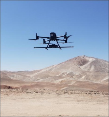
Image 1. Image of MagDrone flying above the Arikepay Property
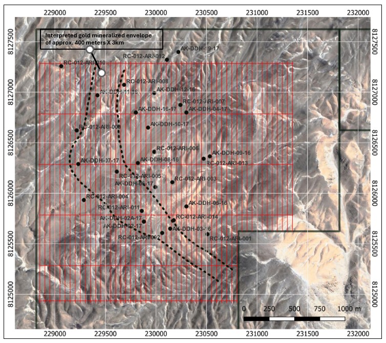
Image 2. Map showing the distribution of the magnetic survey lines flown above the Arikepay Property
Paul A. Dumas, Executive Chairman of Precore Gold, commented, “The launch of this airmag survey is an exciting moment for the Arikepay Project because it allows us to look beyond individual historical drill holes and begin seeing Arikepay as a continual mineral system. Put simply, the survey should help show us where the important structures continue beneath the surface—and where the next compelling drill targets may be hiding. This is the first exciting step in rebuilding the geological story of Arikepay from the ground up. Every new layer of data is intended to sharpen our understanding and improve the quality of the drill targets we ultimately test.
Property Wide View Beneath the Surface
An airborne magnetic survey measures small changes in the Earth’s magnetic field from a drone flying closely spaced lines over the property. In simple terms, it allows the geological team to build a detailed picture of rock types and major geological features beneath surface cover—across the entire Project and far beyond the limited areas tested by historical drilling.
This is particularly important at Precore Gold’s Arikepay Project, as mineralizing fluids commonly travel through faults, fractures and contacts between different rock types. These features can leave magnetic signatures—or areas where magnetism has been reduced by alteration. This will assist the Company’s technical team to trace the broader system. The survey is intended to provide a consistent, high-resolution dataset across the Project and highlight geological patterns that may not be visible from historical drill information alone. Furthermore, Arikepay is mostly covered with several meters of what looks like sand drift (alluvial terrace material), with no visible outcrops or structures. With this information, Precore expects to rank targets more confidently and design drill holes that test the Project’s potential more effectively.
Preliminary results have been received. Upon the completion of the review and interpretation of the new geophysical data, Precore intends to continue additional pre-drilling exploration work at Arikepay in order to finalize drill targets. Results of this campaign and a project update is expected to be shared with the market over the next few weeks.
Qualified Person
The scientific and technical content of this news release has been reviewed and approved by Mr. Louis Gariépy, P.Eng (OIQ #107538), Director & Lead Technical Advisor of Precore Gold, who is a “qualified person” within the meaning of National Instrument 43-101 – Standards of Disclosure for Mineral Projects.
About Precore Gold Corp.
Precore Gold is a Canadian junior gold exploration company focused on building a solid portfolio of exploration projects with strong gold discovery potential, in order to capture the strength of the gold market and to generate long-term shareholder returns. The Company is focused on its flagship properties, the Arikepay property in Arequipa, Peru and the Lac Big-Rush property in Chibougamau, Quebec. The Company plans to seize opportunities whereby promising properties are located in prolific mining camps, in politically stable jurisdictions, that contain important historical drilling results that have not seen any follow-up work in years. Precore Gold's mission is underpinned by diligent environmental, social and corporate governance (ESG) standards.
For shareholder inquiries, please contact:
Paul A. Dumas, Executive Chairman
Email: investor@precoregold.com
Tel: 514-994-1069
www.precoregold.com
Forward-looking statements
This news release contains forward-looking statements. All statements, other than of historical facts, that address activities, events or developments that the Company believes, expects or anticipates will or may occur in the future including, without limitation, the completion of the Second Tranche, future geological work or exploration programs, the potential positive exploration results, the timing of the exploration results, the ability of the Company to finance exploration programs and the potential mineralization or potential mineral resources are forward-looking statements. Forward-looking statements are generally identifiable by use of the words "will", "should", "continue", "expect", "anticipate", "estimate", "believe", "intend", "to earn", "to have', "plan" or "project" or the negative of these words or other variations on these words or comparable terminology. Forward-looking statements are subject to a number of risks and uncertainties, many of which are beyond the Company's ability to control or predict, that may cause the actual results of the Company to differ materially from those discussed in the forward-looking statements. Factors that could cause actual results or events to differ materially from current expectations include, among other things, failure to meet expected, estimated or planned exploration expenditures, failure to establish estimated mineral resources, the possibility that future exploration results will not be consistent with the Company's expectations, general business and economic conditions, changes in world gold markets, sufficient labour and equipment being available, changes in laws and permitting requirements, unanticipated weather changes, title disputes and claims, environmental risks as well as those risks identified in the Company's annual Management's Discussion and Analysis. Should one or more of these risks or uncertainties materialize, or should assumptions underlying the forward-looking statements prove incorrect, actual results may vary materially from those described and accordingly, readers should not place undue reliance on forward-looking statements. Although the Company has attempted to identify important risks, uncertainties and factors which could cause actual results to differ materially, there may be others that cause results not to be as anticipated, estimated or intended. The Company does not intend, and does not assume any obligation, to update these forward-looking statements except as otherwise required by applicable law.
Neither the Canadian Securities Exchange nor its Regulation Services Provider accepts responsibility for the adequacy or accuracy of this release.
Photos accompanying this announcement are available at
https://www.globenewswire.com/NewsRoom/AttachmentNg/3ac180f4-9c6b-4e9b-8557-5704667374e2
https://www.globenewswire.com/NewsRoom/AttachmentNg/cf9aa211-d900-4bab-8fdc-9eb25fdf4c9f



Image 1
Image of MagDrone flying above the Arikepay Property
Image 2
Map showing the distribution of the magnetic survey lines flown above the Arikepay Property
© 2026 Canjex Publishing Ltd. All rights reserved.