PERTH, Australia, June 24, 2026 (GLOBE NEWSWIRE) -- Paladin Energy Ltd (ASX:PDN, TSX:PDN, OTCQX:PALAF) (“Paladin” or the “Company”) announces it has successfully completed its 2026 winter drilling program at the Patterson Lake South (PLS) high-grade uranium project, located in the Athabasca Basin region of Saskatchewan, Canada, with the discovery of a new body of high-grade uranium mineralisation, the Atlas discovery.
Highlights
- High-grade uranium mineralisation has been intersected 3.5km south of Paladin’s Triple R deposit and 4.5km southwest of Saloon East.
- Eight (8) exploration drillholes were collared, with seven intersecting significant uranium mineralisation at the new Atlas discovery, totalling 2,408m.
- Key winter 2026 intercepts at Atlas include:
- PLS26-708B (discovery drillhole): 17.5m of total composite uranium mineralisation across three intervals, the largest being 8.0m averaging 1.75% U3O8, including 3.0m averaging 4.25% U3O8 from 190.0m to 193.0m
- PLS26-718: 21.5m of total composite uranium mineralisation across two intervals, the largest being 14.5m averaging 1.70% U3O8, including 5.5m averaging 2.86% U3O8 from 194.5m to 200.0m
- PLS26-722: 30.0m of total composite uranium mineralisation across seven intervals, the largest being 11.0m averaging 1.79% U3O8, including 5.0m averaging 2.94% U3O8 from 189.0m to 200.0m
- The Atlas discovery remains open along strike and at depth.
After a large-scale ground geophysical survey at the PLS project from February to June 2025, a highly prospective anomaly was identified within the broader Saloon Trend, 4.5km southwest of anomalous uranium concentrations identified at Saloon East. Drill testing of this geophysical anomaly intersected new high-grade basement-hosted uranium mineralisation commencing approximately 160m downhole in what was subsequently named the Atlas discovery. A total of 2,408m of drilling has been completed at Atlas, and the discovery remains open along strike and at depth.
The 2026 winter drilling program also targeted resource conversion and extension drilling at the Triple R deposit and further drilling on the Saloon Trend, along with regional exploration. Following a short seasonal break, drills and field crews were re-mobilised to the PLS project in May to continue work at Atlas as well as other priority target areas. All currently identified trend targets (including Atlas) are land-based, allowing drilling activities to continue uninterrupted throughout the summer months.
Paladin CEO Paul Hemburrow said: “The Atlas discovery is a significant and very positive result for Paladin’s exploration strategy and builds on our success in 2025 with the Saloon East discovery. The initial Atlas results reinforce the potential of the PLS project across multiple prospective mineral corridors and demonstrates the effectiveness of the Company’s systematic targeting approach that is now focused on the land-based trends surrounding Patterson Lake. We also continue drilling the Triple R deposit to upgrade confidence in that resource, focusing on resource to reserve conversion to add value to the life of the mine.”
Overview of Atlas Drill Program
The Saloon Trend is a linear, multi-kilometre long, southwest-northeast trending structural zone up to 1km in width, that is parallel to and located 3.5km south of the shear zones that host the Triple R deposit within the Patterson Lake corridor (Figure 1).
Since 2024, the Saloon Trend has represented a principal exploration focus for the Company, with anomalous uranium geochemistry and associated structural disruption defined over an approximately 8km strike extent. Drill targeting for the 2026 campaign was further refined following completion of a large-scale ground geophysical survey from February to June 2025, which identified high priority geophysical anomalies along the trend.
Although the second drillhole of the 2026 program, PLS26-708, was discontinued at a depth of 152.0m due to challenging ground conditions, a follow-up drillhole, PLS26-708A, successfully intersected three zones of uranium mineralisation before also being discontinued at a depth of 206.0m due to similar ground conditions. The final re-collar, PLS26-708B, was completed as planned and intersected 17.5m of composite uranium mineralisation across three discrete intervals, including 8.0m grading 1.75% U3O8 from 188.0m to 196.0m. This result underpinned the Atlas discovery.
Prior to a seasonal break of drilling activities in May, five additional drillholes were completed at Atlas, bringing the total to 2,408m drilled (Figure 2 and Table 1). Uranium mineralisation was intersected in seven of eight Atlas drillholes, hosted within steeply southeast-dipping stacked shear zones, currently defined over approximately 60m of strike length and at vertical depths ranging from 120m to 260m below surface (Figure 3). The Atlas discovery remains open along strike and at depth, representing one of the main targets for the summer drill program.
In addition to Atlas, eight drillholes were completed at Saloon East, 3.5km southeast of Triple R, totalling 2,759m. Samples for uranium assay from the Saloon East drillholes are currently being processed at the Saskatchewan Research Council Geoanalytical Laboratory.
Table 1: 2026 Atlas Drillhole Summary
| Collar | Basement
depth
(m) | Total
depth
(m) | Uranium Assay Results |
| Hole ID | Easting
(UTM
NAD83) | Northing
(UTM
NAD83) | Elevation
(masl) | Azimuth
(deg) | Dip
(deg) | | | From
(m) | To
(m) | Interval
(m) | U3O8
(%) | Total grade
x thickness
(GxT) |
| PLS26-708 | 598495 | 6386372 | 556 | 341 | -70 | 112.9 | 152.0* | No anomalous uranium mineralisation | N/A |
| PLS26-708A | 598496 | 6386371 | 556 | 331 | -70 | 115.9 | 206.0* | 167.0 | 176.0 | 9.0 | 0.88 | 14.6 |
| | | | | | | | | inc. 168.5 | 169.5 | 1.0 | 2.14 | |
| | | | | | | | | and 173.5 | 175.5 | 2.0 | 1.95 | |
| | | | | | | | | 190.5 | 196.5 | 6.0 | 1.10 | |
| | | | | | | | | inc. 191.0 | 192.5 | 1.5 | 3.51 | |
| | | | | | | | | 203.0 | 205.0 | 2.0 | 0.06 | |
| PLS26-708B | 598496 | 6386371 | 556 | 333 | -69 | 137.0 | 350.0 | 166.5 | 175.0 | 8.5 | 0.53 | 18.6 |
| | | | | | | | | inc. 167.5 | 168.5 | 1.0 | 1.48 | |
| | | | | | | | | 188.0 | 196.0 | 8.0 | 1.75 | |
| | | | | | | | | inc. 190.0 | 193.0 | 3.0 | 4.25 | |
| | | | | | | | | 202.5 | 203.5 | 1.0 | 0.11 | |
| PLS26-711 | 598481 | 6386366 | 555 | 329 | -72 | 109.0 | 383.0 | 192.0 | 192.5 | 0.5 | 0.66 | 0.33 |
| PLS26-716 | 598492 | 6386375 | 556 | 345 | -72 | 112.1 | 345.4 | 165.0 | 170.5 | 5.5 | 0.59 | 17.8 |
| | | | | | | | | inc. 165.5 | 166.5 | 1.0 | 2.11 | |
| | | | | | | | | 174.0 | 175.0 | 1.0 | 0.08 | |
| | | | | | | | | 186.0 | 187.5 | 1.5 | 0.32 | |
| | | | | | | | | 191.0 | 206.0 | 15.0 | 0.93 | |
| | | | | | | | | inc. 192.0 | 195.5 | 3.5 | 3.17 | |
| | | | | | | | | 225.5 | 226.0 | 0.5 | 0.08 | |
| PLS26-718 | 598506 | 6386380 | 556 | 337 | -70 | 121.9 | 368.0 | 173.5 | 180.5 | 7.0 | 0.07 | 25.1 |
| | | | | | | | | 190.5 | 205.0 | 14.5 | 1.70 | |
| | | | | | | | | inc. 194.5 | 200.0 | 5.5 | 2.86 | |
| PLS26-720 | 598491 | 6386376 | 556 | 333 | -68 | 111.0 | 245.0 | 121.5 | 122.0 | 0.5 | 0.09 | 4.2 |
| | | | | | | | | 150.5 | 153.5 | 3.0 | 0.38 | |
| | | | | | | | | 162.0 | 163.5 | 1.5 | 0.32 | |
| | | | | | | | | 167.5 | 174.0 | 6.5 | 0.39 | |
| | | | | | | | | inc. 169.5 | 170.5 | 1.0 | 1.45 | |
| PLS26-722 | 598522 | 6386387 | 557 | 348 | -77 | 111.3 | 359.0 | 189.0 | 200.0 | 11.0 | 1.79 | 30.8 |
| | | | | | | | | inc. 194.5 | 199.5 | 5.0 | 2.94 | |
| | | | | | | | | 205.0 | 206.0 | 1.0 | 2.38 | |
| | | | | | | | | 209.0 | 209.5 | 0.5 | 0.05 | |
| | | | | | | | | 212.0 | 217.0 | 5.0 | 0.17 | |
| | | | | | | | | 230.0 | 236.0 | 6.0 | 0.87 | |
| | | | | | | | | inc. 230.0 | 233.0 | 3.0 | 1.28 | |
| | | | | | | | | 239.0 | 244.5 | 5.5 | 0.43 | |
| | | | | | | | | inc. 239.5 | 241.0 | 1.5 | 1.24 | |
| | | | | | | | | 261.0 | 262.0 | 1.0 | 0.27 | |
*Drillhole terminated due to challenging ground conditions
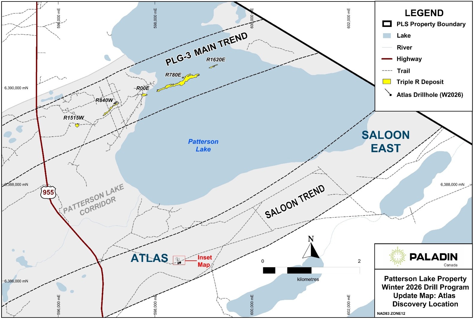
Figure 1: Location of the Atlas discovery
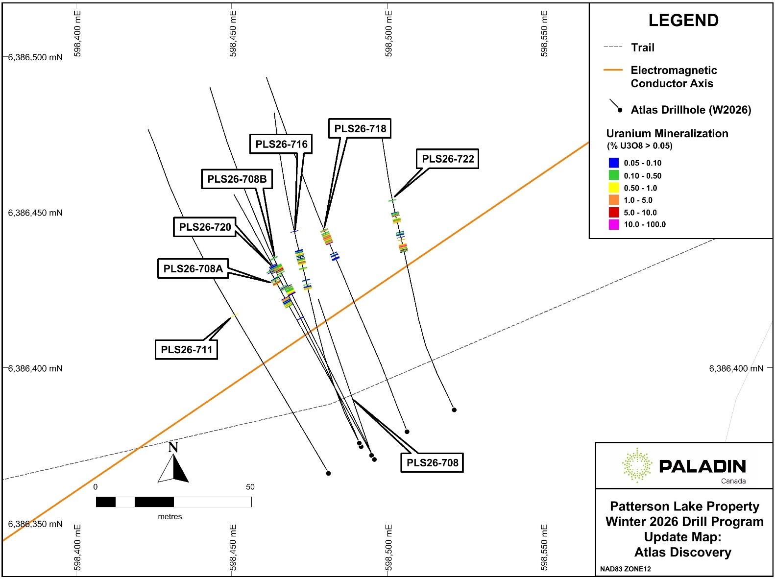
Figure 2: Inset map of Atlas drilling
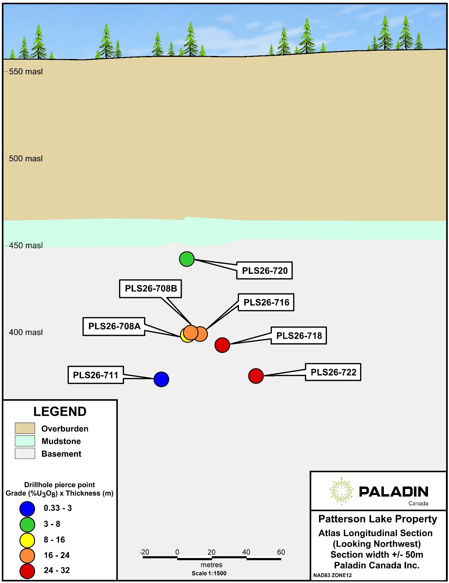
Figure 3: Longitudinal section looking northwest at Atlas showing
total uranium grade (%U3O8) x thickness (m) per drillhole
This announcement has been authorised for release by the Board of Directors of Paladin Energy Ltd.
Contacts
About Paladin
Paladin Energy Ltd (ASX:PDN TSX: PDN OTCQX:PALAF) is a globally significant independent uranium producer with a 75% ownership in Namibia of the world-class long-life Langer Heinrich Mine. In Canada, Paladin is progressing development of the Tier-1, high grade and shallow Patterson Lake South (PLS) Project in northern Saskatchewan and has an extensive portfolio of exploration assets within the province’s highly prospective Athabasca Basin and also at the Michelin project in Newfoundland and Labrador. In Australia, Paladin owns uranium exploration assets in Queensland and Western Australia. Paladin is committed to a sustainability framework that ensures responsible, accountable and transparent management of uranium resources - now and in the future. The Langer Heinrich Mine is delivering reliable uranium supplies to major nuclear utilities around the world, positioning Paladin as a meaningful contributor to baseload energy provision in multiple countries and global decarbonisation, whilst unlocking the PLS Project to support future global nuclear energy expansion.
Competent Person’s Statement / Qualified Person and Technical Information
The drilling and exploration results contained in this document have been prepared in accordance with National Instrument 43-101 Standards of Disclosure for Mineral Projects ("NI 43-101"). The information in this document as it relates to drilling and exploration results is based on, and fairly represents, information and supporting documents prepared by Kanan Sarioglu, a Competent Person and “qualified person” under NI 43-101, who is a registered Professional Geoscientist (P.Geo) with the Engineers and Geoscientists of British Columbia (EGBC), the Association of Professional Engineers and Geoscientists of Alberta (APEGA) and the Association of Professional Engineers and Geoscientists of Saskatachewan (APEGS). Kanan Sarioglu is the VP Exploration for Paladin Canada Inc. and has sufficient experience which is relevant to the style of mineralisation and type of deposit under consideration and to the activity which he is undertaking, to qualify as a Competent Person as defined in the 2012 Edition of the ‘Australasian Code for Reporting of Exploration Results, Mineral Resources and Ore Reserves’. Mr. Sarioglu consents to the inclusion in this document of the matters based on the information in the form and context in which it appears.
The drilling and exploration results including verification of the data disclosed, have been completed by Kanan Sarioglu following NI 43-101. Mr. Sarioglu has reviewed and approved the contents of this news release.
The design of the drilling programs and interpretation of results is under the control of Paladin Canada’s geological staff, including qualified persons employing strict protocols consistent with NI 43-101 and industry best practices. Drill core samples are analysed at the Saskatchewan Research Council (SRC) Geoanalytical Laboratories (an SCC ISO/IEC 17025: 2005 Accredited Facility) in Saskatoon, Saskatchewan, which includes U3O8 (wt %) and fire assay for gold.
All intersections are down-hole depths. All depths reported of core interval measurements including radioactivity and mineralisation intervals widths are not always representative of true thickness.
Forward-looking statements
This document contains certain “forward-looking statements” within the meaning of Australian securities laws and “forward-looking information” within the meaning of Canadian securities laws (collectively referred to in this document as forward-looking statements). All statements in this document, other than statements of historical or present facts, are forward-looking statements and generally may be identified by the use of forward-looking words such as “anticipate”, “expect”, “likely”, “propose”, “will”, “intend”, “should”, “could”, “may”, “believe”, “forecast”, “estimate”, “target”, “outlook”, “guidance” and other similar expressions.
Forward-looking statements involve subjective judgment and analysis and are subject to significant uncertainties, risks and contingencies including those risk factors associated with the mining industry, many of which are outside the control of, change without notice, and may be unknown to Paladin. These risks and uncertainties include but are not limited to liabilities inherent in mine development and production, geological, mining and processing technical problems, the inability to obtain any additional mine licences, permits and other regulatory approvals required in connection with mining and third party processing operations, competition for amongst other things, capital, acquisition of reserves, undeveloped lands and skilled personnel, incorrect assessments of the value of acquisitions, changes in commodity prices and exchange rates, currency and interest fluctuations, various events which could disrupt operations and/or the transportation of mineral products, including labour stoppages and severe weather conditions, rising energy costs, inflationary pressures, the demand for and availability of transportation services, the ability to secure adequate financing and management's ability to anticipate and manage the foregoing factors and risks.
Although at the date of this announcement Paladin believes the expectations expressed in such forward-looking statements are based on reasonable assumptions, such statements are not guarantees of future performance. Actual results or developments may differ materially from the expectations expressed in such forward-looking statements due to a range of factors including (without limitation) fluctuations in commodity prices and exchange rates, exploitation and exploration successes, environmental, permitting and development issues, geopolitical events and political risks (including armed conflict or escalation of hostilities in the Middle East), and the impact of such events on global security conditions, economic activity, trade flows, energy markets, sanctions regimes, and uranium supply and demand, First Nation engagement, climate risk, operating hazards, natural disasters, severe storms and other adverse weather conditions, shortages of skilled labour and construction materials, equipment and supplies, energy costs, inflation, regulatory concerns, continued availability of capital and financing and general economic, market or business conditions and risk factors associated with the uranium industry generally, and other factors. There can be no assurance that forward-looking statements will prove to be accurate.
Readers should not place undue reliance on forward-looking statements, and should rely on their own independent enquiries, investigations and advice regarding information contained in this document. Any reliance by a reader on the information contained in this document is wholly at the reader’s own risk. Recipients are cautioned against placing undue reliance on such projections without conducting their own due diligence with appropriate professional support. The forward-looking statements in this document relate only to events or information as of the date on which the statements are made. Paladin does not assume any obligation to update or revise its forward-looking statements, whether as a result of new information, future events or otherwise. No representation, warranty, guarantee or assurance (express or implied) is made, or will be made, that any forward-looking statements will be achieved or will prove to be correct. Except for statutory liability which cannot be excluded, Paladin, its officers, employees and advisers expressly disclaim any responsibility for the accuracy or completeness of the material contained in this document and exclude all liability whatsoever (including negligence) for any loss or damage which may be suffered by any person as a consequence of any information in this document or any error or omission therefrom. Except as required by law or regulation, Paladin accepts no responsibility to update any person regarding any inaccuracy, omission or change in information in this document or any other information made available to a person, nor any obligation to furnish the person with any further information. Nothing in this document will, under any circumstances, create an implication that there has been no change in the affairs of Paladin since the date of this document. To the extent any forward-looking statement in this document constitutes “future-oriented financial information” or “financial outlooks” within the meaning of Canadian securities laws, such information is provided to demonstrate Paladin’s internal projections and to help readers understand Paladin’s expected financial results. Readers are cautioned that this information may not be appropriate for any other purpose and readers should not place undue reliance on such information. Future-oriented financial information and financial outlooks, as with forward-looking statements generally, are, without limitation, based on the assumptions, and subject to the risks and uncertainties, described above.
JORC Code, 2012 Edition – Table 1
Section 1 Sampling Techniques and Data
(Criteria in this section apply to all succeeding sections.)
| Criteria | JORC Code explanation | Commentary |
| Sampling techniques | - Nature and quality of sampling (e.g. cut channels, random chips, or specific specialised industry standard measurement tools appropriate to the minerals under investigation, such as down hole gamma sondes, or handheld XRF instruments, etc). These examples should not be taken as limiting the broad meaning of sampling.
- Include reference to measures taken to ensure sample representivity and the appropriate calibration of any measurement tools or systems used.
- Aspects of the determination of mineralisation that are Material to the Public Report.
- In cases where ‘industry standard’ work has been done this would be relatively simple (e.g. ‘reverse circulation drilling was used to obtain 1 m samples from which 3 kg was pulverised to produce a 30 g charge for fire assay’). In other cases, more explanation may be required, such as where there is coarse gold that has inherent sampling problems. Unusual commodities or mineralisation types (e.g. submarine nodules) may warrant disclosure of detailed information.
| - Drilling related to this release was carried out using a conventional coring drill rig.
- Drill core that returned handheld RS-121 scintillometer readings equal to or greater than 300 counts per second (cps) relative to a background of 100 counts per second was marked for sampling and split in half along the core axis into 50-centimetre core-length samples.
- One half of the core was placed into a labelled sample bag and sent for geochemical analysis and weight percent (wt%) U₃O₈ assay, while the other half remained in the core box as a permanent record.
- Core samples for geochemistry and U₃O₈ assay were crushed to 60% passing −2 mm, and a 100 g to 200 g sub-sample was split using a riffle splitter. The sub-sample was then pulverized to 90% passing 106 μm using a standard puck-and-ring grinding mill. An aliquot of the pulp was digested in a concentrated mixture of HNO₃:HCl in a hot water bath for one hour and was then diluted with de-ionized water. The samples were analysed using a Perkin Elmer ICP-OES instrument.
|
| Drilling techniques | - Drill type (e.g. core, reverse circulation, open-hole hammer, rotary air blast, auger, Bangka, sonic, etc) and details (e.g. core diameter, triple or standard tube, depth of diamond tails, face-sampling bit or other type, whether core is oriented and if so, by what method, etc).
| - All drilling reported in this release was completed using a Zinex A5 core drill.
- Drillholes PLS26-708 and 708A were drilled entirely as NQ diameter core (47.6mm).
- Drillholes PLS26-708B and 711 began as NQ diameter core which was reduced to BQ diameter (36.4 mm) coring during drilling due to poor ground conditions.
- PLS26-716, 718, 720 and 722 began as HQ diameter (63.5 mm) core at the top of bedrock which was reduced to NQ diameter core once ground conditions improved.
- Drill core is orientated by the logging geologist, with orientation marks provided by an IMDEX ACTIII.
|
| Drill sample recovery | - Method of recording and assessing core and chip sample recoveries and results assessed.
- Measures taken to maximise sample recovery and ensure representative nature of the samples.
- Whether a relationship exists between sample recovery and grade and whether sample bias may have occurred due to preferential loss/gain of fine/coarse material.
| - Drill core was logged geotechnically on a run-by-run or ISRM rock strength basis and included the number of naturally occurring fractures, mechanical fractures, intact core recovery, rock quality designation (RQD), ISRM rock strength, longest stick, and radioactivity measured in cps.
- Core recovery was generally very good, which allowed representative samples to be taken and accurate analyses to be performed.
- Presence of radioactivity was used to confirm areas of poor core recovery using a downhole gamma probe.
- No sampling bias was observed due to preferential loss or gain of drill core.
|
| Logging | - Whether core and chip samples have been geologically and geotechnically logged to a level of detail to support appropriate Mineral Resource estimation, mining studies and metallurgical studies.
- Whether logging is qualitative or quantitative in nature. Core (or costean, channel, etc) photography.
- The total length and percentage of the relevant intersections logged.
| - All drill core was descriptively logged by a Paladin Canada Inc. geologist, with particular attention given to major and minor lithologies, alteration, structure, and uranium mineralisation.
- Paladin Canada Inc. geotechnicians recorded drill core recovery, rock RQD, rock strength, longest stick, natural breaks, joint condition, weathering grade, discontinuity features, and radioactivity.
- Logging and sampling information was entered into a spreadsheet-based template, which was reviewed and was then integrated into the project’s digital database.
- All drill core was photographed while wet using a digital camera before sampling.
- Drill core was logged geologically and geotechnically in sufficient detail to support mineral resource estimation.
|
| Sub-sampling techniques and sample preparation | - If core, whether cut or sawn and whether quarter, half or all core taken.
- If non-core, whether riffled, tube sampled, rotary split, etc and whether sampled wet or dry.
- For all sample types, the nature, quality and appropriateness of the sample preparation technique.
- Quality control procedures adopted for all sub-sampling stages to maximise representivity of samples.
- Measures taken to ensure that the sampling is representative of the in-situ material collected, including for instance results for field duplicate/second-half sampling.
- Whether sample sizes are appropriate to the grain size of the material being sampled.
| - All core samples were standardized to half-meter lengths, except in zones of poor recovery (<25%) where the interval length was adjusted.
- All core samples consisted of half-split drill core that was split parallel to the core axis. Half of the drill core from each sample interval was placed into a marked and tagged sample bag, while the remaining half was left in the core box as a permanent record.
- Drill core was half-split using a manual core splitter, with efforts made to ensure consistent representativity.
- Duplicate samples were collected from each mineralised drillhole, except for PLS26-711 due to the thin zone of mineralisation.
- In thicker zones of mineralisation, a duplicate was taken every 10 m throughout the zone.
- Because drill core samples covered the full half-meter interval, they were considered appropriate in size relative to the material being sampled.
|
| Quality of assay data and laboratory tests | - The nature, quality and appropriateness of the assaying and laboratory procedures used and whether the technique is considered partial or total.
- For geophysical tools, spectrometers, handheld XRF instruments, etc, the parameters used in determining the analysis including instrument make and model, reading times, calibrations factors applied and their derivation, etc.
- Nature of quality control procedures adopted (e.g. standards, blanks, duplicates, external laboratory checks) and whether acceptable levels of accuracy (i.e. lack of bias) and precision have been established.
| - Drill core samples were sent to the Saskatchewan Research Council (SRC) Geoanalytical Laboratory in Saskatoon, Saskatchewan, an SCC ISO/IEC 17025:2005 accredited facility. Uranium assay samples were analysed using the U₃O₈ wt% package, which was an ISO/IEC 17025 accredited method for determining U₃O₈ wt% in geological samples. For this package, an aliquot of sample pulp was digested in a concentrated HCl:HNO₃ mixture, the digest was diluted with deionized water, and the solution was analysed by ICP-OES.
- The SRC Geoanalytical Laboratory inserted Certified Reference Material (CRM) samples for every 20 samples analysed and performed duplicate analyses every 40 samples. SRC CRM and duplicate results were monitored by Paladin upon receipt.
- Paladin’s internal quality assurance–quality control program included the following components:
- Determination of precision — was achieved through regular insertion of duplicate samples at each stage of the process where a sample was taken or split.
- Determination of accuracy — was achieved through regular insertion of CRM samples.
- Checks for contamination — were carried out through the insertion of blanks.
- CRM were sourced from the Canadian Certified Reference Materials Project. UTS-3 (0.051% U₃O₈), RL-1 (0.201% U₃O₈), BL-5 (8.36% U₃O₈) representing low-, medium- and high-grade uranium references, respectively.
- CRM were inserted into the sample sequence for each drillhole that intersected >300 cps radioactivity on a handheld scintillometer.
- Blanks were also inserted into the sample sequence for these drillholes and were sourced from barren quartz veins intersected on the PLS property in historical drillholes.
- Duplicate samples were taken per mineralised drillhole, or every 20 mineralised samples in thicker zones of mineralisation and consisted of the remaining half-split core from the sample interval.
- CRM, blanks, and duplicates aimed to comprise approximately 5% of the total samples sent to the laboratory.
- Uranium results for CRM and blanks were reviewed upon receipt from the laboratory. CRM failure criteria were triggered when a sample fell outside three standard deviations of the expected value, or when two consecutive samples fell outside two standard deviations on the same side. Blank failure criteria were triggered when a sample returned a uranium concentration greater than five times the U₃O₈ assay detection limit.
- In the event of a CRM or blank failure, the entire batch containing the failed CRM was reanalysed, and if the reanalysed batch passed, those sample values were used.
|
| Verification of sampling and assaying | - The verification of significant intersections by either independent or alternative company personnel.
- The use of twinned holes.
- Documentation of primary data, data entry procedures, data verification, data storage (physical and electronic) protocols.
- Discuss any adjustment to assay data.
| - Significant intersections have not been verified by independent or alternative company personnel.
- No holes have been twinned.
- All drillhole data was compiled and reviewed upon completion and was then imported and validated in Seequent MX Deposit and Bentley GEMS by Paladin staff.
- One 50-centimetre sample from PLS26-708B was incorrectly split in the field and was separated into a 20 centimetre and 30-centimeter sample. A weighted average grade was calculated for a 50-centimetre composite.
|
| Location of data points | - Accuracy and quality of surveys used to locate drill holes (collar and down-hole surveys), trenches, mine workings and other locations used in Mineral Resource estimation.
- Specification of the grid system used.
- Quality and adequacy of topographic control.
| - All drillhole collars are positioned using a Trimble real time kinematic GPS system.
- All coordinates are in UTM NAD83.
- Drillholes are aligned to the planned azimuth and dip using an IMDEX TN-14 azimuth aligner.
- A final collar position was collected using the Trimble GPS once the drill has moved off the site.
- Drillhole azimuth and dip information is measured every 50 m during drilling using a REFLEX EZ-Trac and every 10 m upon completion using a Stockholm Precision Tools North Seeking Gyro.
- The PLS property has a detailed digital terrane model to provide topographic control.
|
| Data spacing and distribution | - Data spacing for reporting of Exploration Results.
- Whether the data spacing and distribution is sufficient to establish the degree of geological and grade continuity appropriate for the Mineral Resource and Ore Reserve estimation procedure(s) and classifications applied.
- Whether sample compositing has been applied.
| - Pierce point spacing for exploration drilling can vary between 15 to 50 metres depending on the geology and level of radioactivity encountered.
- Drillhole pierce point spacing is considered appropriate for the current exploration stage of drillholes in this release.
|
| Orientation of data in relation to geological structure | - Whether the orientation of sampling achieves unbiased sampling of possible structures and the extent to which this is known, considering the deposit type.
- If the relationship between the drilling orientation and the orientation of key mineralised structures is considered to have introduced a sampling bias, this should be assessed and reported if material.
| - Drilling orientations are generally sub-perpendicular to the interpreted dip of geology, but there is limited knowledge of the geology in exploration areas.
- It is noted within the release that all uranium assay intervals are core lengths and not true widths.
|
| Sample security | - The measures taken to ensure sample security.
| - Drill core samples were stored in tamper-proof pails with locking lids at the PLS core logging facility until shipment. Sample pails were counted and loaded onto a transport truck for shipment, accompanied by Dangerous Goods paperwork that outlined the number of pails and the total radioactivity of the shipment. Pail numbers and samples were verified by the SRC upon arrival. A strict chain of custody was maintained for transporting radioactive sample pails from PLS to the SRC.
|
| Audits or reviews | - The results of any audits or reviews of sampling techniques and data.
| - No audits or reviews of the data presented in this release have occurred.
|
Section 2 Reporting of Exploration Results
(Criteria listed in the preceding section also apply to this section.)
| Criteria | JORC Code explanation | Commentary |
| Mineral tenement and land tenure status | - Type, reference name/number, location and ownership including agreements or material issues with third parties such as joint ventures, partnerships, overriding royalties, native title interests, historical sites, wilderness or national park and environmental settings.
- The security of the tenure held at the time of reporting along with any known impediments to obtaining a licence to operate in the area.
| - Drilling from Atlas presented in this release was completed on mineral claim S-112283 which is 100% owned by Paladin Canada Inc.
- Saloon East drilling referenced in this release was completed on mineral claim S-111376.
- All claims are in good standing and all necessary permits for drilling and geophysical surveys have been received.
|
| Exploration done by other parties | - Acknowledgment and appraisal of exploration by other parties.
| - The PLS project has been explored by a number of historical exploration companies including Uranerz Exploration and Mining Ltd., Hudson Bay Exploration and Development and Canadian Occidental Petroleum Ltd.
- There are historical drillholes on the property, none of which have tested the areas presented in this announcement.
|
| Geology | - Deposit type, geological setting and style of mineralisation.
| - The target deposit type is unconformity-associated high-grade uranium, hosted at the base of the Athabasca Basin or underlying metamorphic basement rocks.
|
| Drill hole Information | - A summary of all information material to the understanding of the exploration results including a tabulation of the following information for all Material drill holes:
- easting and northing of the drill hole collar
- elevation or RL (Reduced Level – elevation above sea level in metres) of the drill hole collar
- dip and azimuth of the hole
- down hole length and interception depth
- hole length.
- If the exclusion of this information is justified on the basis that the information is not Material and this exclusion does not detract from the understanding of the report, the Competent Person should clearly explain why this is the case.
| - This information is included in Table 1 of the main body of the announcement.
- No material information has been excluded.
|
| Data aggregation methods | - In reporting Exploration Results, weighting averaging techniques, maximum and/or minimum grade truncations (e.g. cutting of high grades) and cut-off grades are usually Material and should be stated.
- Where aggregate intercepts incorporate short lengths of high-grade results and longer lengths of low-grade results, the procedure used for such aggregation should be stated and some typical examples of such aggregations should be shown in detail.
- The assumptions used for any reporting of metal equivalent values should be clearly stated.
| - All drill core samples are standardized to 50-centimetres in length.
- One 50-centimetre sample from PLS26-708B was incorrectly split in the field and was separated into a 20-centimetre and 30-centimeter sample. A weighted average grade was calculated for a 50-centimetre composite.
- Intervals of uranium mineralisation shown in Table 1 use a cut-off grade of 0.05% U3O8 over a minimum core length of 50-centimetres, and do not contain more than two consecutive meters of internal dilution.
- High-grade sub-intervals in Table 1 comprise at least 1 metre of consecutive mineralisation grading ≥1% U3O8.
- “Total composite mineralisation” is the sum total of intervals ≥0.05% U3O8 over ≥0.5 m per drillhole.
- Grade x (times) thickness (GxT) values were determined by multiplying the average uranium grade in an interval by its width.
|
| Relationship between mineralisation widths and intercept lengths | - These relationships are particularly important in the reporting of Exploration Results.
- If the geometry of the mineralisation with respect to the drill hole angle is known, its nature should be reported.
- If it is not known and only the down hole lengths are reported, there should be a clear statement to this effect (e.g. ‘down hole length, true width not known’).
| - All intervals are down hole lengths.
- Due to the early-stage nature of these results, true widths are not known at this time.
|
| Diagrams | - Appropriate maps and sections (with scales) and tabulations of intercepts should be included for any significant discovery being reported These should include but not be limited to a plan view of drill hole collar locations and appropriate sectional views.
| - Refer to the figures in the main body of the announcement.
|
| Balanced reporting | - Where comprehensive reporting of all Exploration Results is not practicable, representative reporting of both low and high grades and/or widths should be practiced to avoid misleading reporting of Exploration Results.
| - All relevant exploration data has been reported.
|
| Other substantive exploration data | - Other exploration data, if meaningful and material, should be reported including (but not limited to): geological observations; geophysical survey results; geochemical survey results; bulk samples – size and method of treatment; metallurgical test results; bulk density, groundwater, geotechnical and rock characteristics; potential deleterious or contaminating substances.
| - All relevant exploration data has been reported.
|
| Further work | - The nature and scale of planned further work (e.g. tests for lateral extensions or depth extensions or large-scale step-out drilling).
- Diagrams clearly highlighting the areas of possible extensions, including the main geological interpretations and future drilling areas, provided this information is not commercially sensitive.
| - Drilling is ongoing, with the next steps being outlined within the main body of the announcement.
|
Figures accompanying this announcement are available at:
https://www.globenewswire.com/NewsRoom/AttachmentNg/f5b4ab0d-9e68-40e9-8512-d2de9247ca98
https://www.globenewswire.com/NewsRoom/AttachmentNg/9779c77f-c9b8-4514-a276-770c49d483e7
https://www.globenewswire.com/NewsRoom/AttachmentNg/fa339109-8ffa-4180-9461-941ed8ef750e


Figure 1
Location of the Atlas discovery
Figure 2
Inset map of Atlas drilling
Figure 3
Longitudinal section looking northwest at Atlas showing total uranium grade (%U3O8) x thickness (m) per drillhole
© 2026 Canjex Publishing Ltd. All rights reserved.