Toronto, Ontario--(Newsfile Corp. - October 16, 2026) - ONGold Resources Ltd. (TSXV: ONAU) (OTCQB: ONGRF) (the "Company" or "ONGold") announces that Evolution Mining Exploration and Development (Canada) Ltd. ("Evolution") delivered notice to ONGold that it was withdrawing from and terminating the earn-in and joint venture agreement dated November 6, 2023, as assigned to ONGold pursuant to an assignment and assumption agreement dated September 5, 2024 (the "Earn-In Agreement"), in respect of the October Gold Project ("October Gold" or the "Project") (the "Termination Notice"). The termination will become effective on October 15, 2026, following which ONGold will retain its 100% interest in the Project, free of Evolution's earn-in right under the Earn-In Agreement, and will assume operatorship of the Project. October Gold is a district-scale property comprising 1,308 claims covering 271 km² (27,082 ha) in northeastern Ontario, within the Archean Swayze Greenstone Belt, 105 km southwest of Timmins and 35 km northwest of IAMGOLD Corporation's ("IAMGOLD") producing Côté Gold Mine, whose claims are contiguous with the Project's southeastern boundary (Figure 1). The property is accessible by an all-season highway and a network of forestry roads.
October Gold Highlights:
Located 35 km northwest of IAMGOLD's Côté Gold Mine, which hosts a reported consolidated open-pit Mineral Resource Estimate (Côté and Gosselin zones) of 20.34 Moz of contained gold at 0.75 g/t Au (Measured and Indicated) plus 3.48 Moz of contained gold at 0.61 g/t Au (Inferred) (IAMGOLD, 2026).
Contiguous with IAMGOLD's claims. IAMGOLD's claims adjoin the southeastern boundary of the October Gold Property along the regional Ridout Deformation Zone ("RDZ") structural corridor (Figure 2).
District-scale, largely underexplored land package in the Swayze Greenstone Belt of Ontario.
Historical exploration has focused on the central and north-central portions of the property, leaving the remainder largely underexplored.
Exploration targets, including largely overlooked porphyry bodies and rock types comparable to those associated with gold deposits to the southeast, complex fold structures, historical gold showings, and parallel and splay structures off the RDZ, will be the focus of ONGold's exploration programs.
The RDZ, which transects the property for approximately 15 km, is interpreted as the western continuation into the Swayze Greenstone Belt of the Cadillac–Larder Lake Break, a major gold-bearing fault network in the Abitibi Greenstone Belt and is spatially associated with two major gold deposits in the Swayze belt, Côté Gold and the past-producing Jerome Mine.
On strike with the historic Jerome gold-silver mine. The property lies 12 km west-northwest of the Jerome Mine, which produced 56,898 oz of gold and 15,105 oz of silver between 1941 and 1943 (Rochefort, 2023). In 2011, Augen Gold Corp. reported a historical NI 43-101 Inferred Mineral Resource Estimate for the Jerome Mine property of 18.7 Mt at 1.7 g/t Au containing 1.03 Moz of gold (Burt et al., 2011).
Exploration permit application planned for fall 2026 to support proposed ground geophysical surveys and a potential future drill program, with a site visit to the Woman River area tentatively scheduled for late October or November 2026.
Kyle Stanfield, Chief Executive Officer and a director of ONGold, commented: "The return of full control and operatorship of October Gold will be a meaningful strategic milestone for ONGold. With much of this district-scale property still underexplored, we see a clear opportunity to unlock value through systematic, technically driven exploration. The project sits in a proven gold corridor alongside major gold deposits such as IAMGOLD's Côté Gold and the past-producing Jerome Mine, reinforcing the geological strength of this land position in the Swayze Greenstone Belt. The range of high-quality targets across the land package, including porphyry bodies, underscores the scale of the opportunity ahead. Our team is committed to disciplined geological work, targeted geophysics and a structured exploration program designed to surface new discoveries and create long-term value for shareholders."
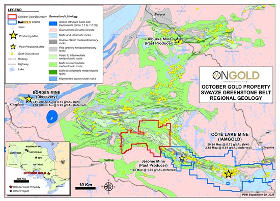
Figure 1: October Gold Property location and regional geology of the Swayze Greenstone Belt, showing gold showings and known gold deposits, including IAMGOLD's Côté Gold Mine and the past-producing Jerome Mine
To view an enhanced version of this graphic, please visit:
https://images.newsfilecorp.com/files/10770/319083_948e49a3946a4997_001full.jpg
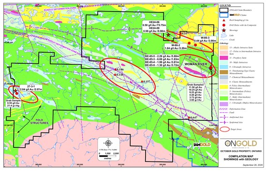
Figure 2: Geology and prospective exploration targets across the October Gold Property, with IAMGOLD's contiguous claims to the southeast
To view an enhanced version of this graphic, please visit:
https://images.newsfilecorp.com/files/10770/319083_948e49a3946a4997_002full.jpg
Woman River Area
A large porphyry intrusive body (system) with a strike length of approximately 3.0 km, hosted in intermediate to felsic metavolcanic rocks, has not previously been explored or drill tested and requires field investigation and geophysical surveying to define drill targets.
Historical surface grab samples collected from trenches at the Woman River Zone, near the eastern claim boundary, returned 11.50, 10.25, 9.23, 4.44, 3.73 and 3.65 g/t Au. Grab samples are selective by nature and are not necessarily representative of the mineralization hosted on the property.
In 1985, Noranda Exploration Co. Ltd. drilled eight holes totaling 1,338 m on the Woman River Zone, intersecting gold mineralization associated with sheared and altered mafic volcanic rocks and porphyry dykes over an approximately 200 m strike length (Corstorphine, 1985). The best intercepts are summarized in Table 1. Holes BE-85-5 and BE-85-9 were collared on the October Gold property; the remaining holes tested the same zone up to 160 m east of the property boundary, on the adjoining property.
The Woman River Zone remains open along strike to the east beyond the limits of the historical drilling described above.
Table 1: 1985 Noranda Drill Hole Gold Intercept Highlights – Woman River Zone
| Historical Hole | g/t Au | From (m) | To (m) | Length (m) |
| BE-85-5* | 2.29 | 90.85 | 96.65 | 5.80 |
| Incl. | 6.17 | 94.10 | 94.94 | 0.84 |
| BE-85-9* | 0.88 | 112.50 | 119.76 | 7.26 |
| Incl. | 1.30 | 113.84 | 117.56 | 3.72 |
| * Collared on October Gold ground. |
| Adjoining Property | g/t Au | From (m) | To (m) | Length (m) |
| BE-85-1 | 5.04 | 41.83 | 45.52 | 3.69 |
| Incl. | 19.47 | 42.47 | 43.08 | 0.61 |
| BE-85-2 | 1.23 | 34.36 | 35.40 | 1.04 |
| BE-85-3 | 6.69 | 108.84 | 110.67 | 1.83 |
| BE-85-4 | 1.85 | 88.32 | 94.57 | 6.25 |
| Incl. | 1.99 | 90.76 | 94.57 | 3.81 |
| BE-85-6 | 5.31 | 92.41 | 96.25 | 3.84 |
| Note: Intervals are core lengths and do not represent true widths. |
Northwest Structures
- Follow-up is warranted along the projected strike extension of northwest-trending LiDAR linear features. Publicly reported drilling on adjoining ground includes an intercept of 0.50 g/t Au over a core length of 75.75 m in hole HE24-06, located outside the October Gold Property, and other historical intercepts on strike along the same or similar structures, including holes W-86-2 (1.84 g/t Au over 3.20 m) and W-86-3 (0.44 g/t Au over 3.90 m).
Central Ridout Deformation Zone
- Three porphyry intrusive bodies warrant further investigation, given the association of significant gold mineralization with porphyry bodies along the RDZ at the past-producing Jerome Mine and at IAMGOLD's producing Côté Gold Mine.
Southwest Fold Structures
- Numerous fold hinges and related structures identified from LiDAR and historical geological mapping in the southwest portion of the property, where a historical grab sample returned 0.55 g/t Au and 21.4 g/t Ag and historical drill hole 27-3-1 returned 2.84 g/t Au over 2.07 m.
Planned Exploration
ONGold plans to initiate an exploration permit application in fall 2026 to support proposed ground geophysical surveys and a potential future drill program, with a site visit to the Woman River area tentatively scheduled for late October or November 2026. In 2027, the Company will begin with geological compilation and target refinement, followed by an anticipated summer field program comprising geological mapping, prospecting and sampling, ground geophysical surveys (induced polarization and magnetics) and soil geochemical sampling.
October Gold Background
Northern Superior Resources Inc. ("Northern Superior") acquired the Project in 2022 through its acquisition of Genesis Metals Corp. On November 6, 2023, Northern Superior announced that it had entered into the Earn-In Agreement with Evolution, under which Evolution was granted the right to acquire a 75% undivided interest in the October Gold Project by incurring aggregate expenditures of $7 million and making aggregate cash payments of $1.1 million over five years. On April 26, 2024, ONGold acquired the October Gold Property, the Tipihakaaning ("TPK") Project and several other Ontario properties as part of the spinout of Ontario exploration assets from Northern Superior. Evolution confirmed in the Termination Notice that it had funded aggregate expenditures of at least $2.5 million under the Earn-In Agreement. The termination of the Earn-In Agreement will become effective on October 15, 2026, following which ONGold will retain its 100% interest in the Project, free of Evolution's earn-in right under the Earn-In Agreement, and will assume operatorship of the Project.
References
Burt, P., Chance, P. and Burns, J., 2011: "Technical Report on a Resource Estimate on the Jerome Mine Property", prepared for Augen Gold Corp., effective date July 18, 2011, signing date August 6, 2011, 92 pp.
Corstorphine, W., 1985: "Report on 1985 Phase II Diamond Drilling, Berle Project, Mallard Township, Ontario", prepared by Noranda Exploration Co. Ltd., December 1985, assessment file OM85-5-C-127, 63.5188, 166 pp.
IAMGOLD Corporation, 2026: news release entitled "IAMGOLD Announces Consolidated Mineral Resource Estimate for Côté Gold", dated June 1, 2026, available on IAMGOLD's website.
Link: https://www.iamgold.com/English/investors/news-releases/news-releases-details/2026/IAMGOLD-Announces-Consolidated-Mineral-Resource-Estimate-for-Ct-Gold/default.aspx
Rochefort, M., 2023: "Assessment Report, 2022 Exploration Program, October Property", prepared for Northern Superior Resources Inc., dated March 30, 2023, 505 pp.
Qualified Person
The scientific and technical information in this news release has been reviewed and approved by Paul Dunbar, P.Geo., Vice President Exploration of ONGold, a "Qualified Person" as defined in National Instrument 43-101 – Standards of Disclosure for Mineral Projects ("NI 43-101"). Mr. Dunbar is not independent of the Company. The Qualified Person has not independently verified all historical sampling and drilling procedures or all underlying historical assay data but considers the historical information sufficiently reliable for the limited purpose of guiding the Company's current exploration activities. All historical drill intervals reported in this news release are core lengths; true widths have not been determined.
Nibinamik First Nation Protection and Collaboration Agreement
On July 24, 2026, ONGold entered into a binding protection and collaboration agreement with Nibinamik First Nation ("Nibinamik") regarding the Company's proposed 2026 exploration activities at the TPK Project (the "Nibinamik Agreement"). Under the Nibinamik Agreement, ONGold has committed up to $327,100 in community-related payments, including community infrastructure, engagement, and social investment. The agreement also provides for employment and procurement opportunities for qualified community members where appropriate including continued ONGold-Nibinamik project coordination.
Subject to applicable securities laws and TSX Venture Exchange ("TSXV") acceptance, ONGold has agreed to issue Nibinamik common shares valued at $100,000, based on a 30-day volume-weighted average trading price and subject to applicable TSXV pricing requirements. The shares will be subject to applicable securities-law and TSXV resale restrictions and contractual restrictions releasing 25% four months and one day after issuance and a further 25% at each of six, nine and twelve months. No finder's fee is payable.
Cautionary Note Regarding Adjacent Properties and Historical Estimates.
The mineral resource estimates for IAMGOLD's Côté Gold Mine and for the Jerome Mine property referenced in this news release relate to properties in which ONGold has no interest, and mineralization on adjacent or nearby properties is not necessarily indicative of mineralization on the October Gold Property. The Jerome estimate is a historical estimate: a qualified person has not done sufficient work to classify it as current mineral resources or mineral reserves, and the Company is not treating it as current mineral resources or mineral reserves. ONGold has not independently verified the IAMGOLD or Jerome estimates.
About ONGold Resources Ltd.
ONGold Resources Ltd. owns significant exploration assets in Northern Ontario and Northern Manitoba, including the district-scale Monument Bay Gold-Tungsten Project, TPK Gold Project, Domain Gold Project and October Gold Project. These projects represent a strategic footprint in one of Canada's most prolific gold-producing regions.
With its extensive technical expertise, strong commitment to social acceptability, mindful Indigenous engagement and partnerships, and a proven track record of responsible exploration, ONGold's team is uniquely positioned to unlock the full potential of its portfolio of projects.
ONGold Resources Ltd. on behalf of the Board of Directors
Kyle Stanfield, Chief Executive Officer and Director
Neither the TSX Venture Exchange nor its Regulation Services Provider (as that term is defined in the policies of the TSX Venture Exchange) accepts responsibility for the adequacy or accuracy of this release.
Cautionary Note Regarding Forward-Looking Information
This news release contains "forward-looking information" within the meaning of applicable Canadian securities laws. Forward-looking information in this news release includes, but is not limited to, statements regarding the expected effectiveness of the termination of the Evolution option agreement and ONGold's expected assumption of full control and operatorship of the October Gold Project; the Company's exploration plans for the Project, including the timing of the exploration permit application, the planned ground geophysical surveys, geological mapping, prospecting and sampling, the potential future drill program, and the proposed site visit; the interpretation of geological, geophysical and historical exploration information and the identification of exploration targets; the potential for the Project to host gold mineralization; the potential for the Company's exploration activities to result in new discoveries or create long-term value for shareholders; and the Company's business and exploration strategy.
Forward-looking information is based on assumptions considered reasonable by management as of the date of this news release, including assumptions regarding the termination becoming effective on October 15, 2026 in accordance with the Earn-In Agreement and the orderly completion of the transition of operatorship and project information from Evolution to ONGold; the availability of financing, personnel, equipment and contractors; the ability to obtain required permits and approvals; access to the October Gold Project; coordination with local First Nation communities; the accuracy and reliability of historical and current geological, geophysical and assay information; and general business, economic and market conditions. Forward-looking information is subject to known and unknown risks, uncertainties and other factors that may cause actual results, performance or achievements to differ materially from those expressed or implied by such information. These risks and uncertainties include delays or disputes relating to the effectiveness of the termination, the transition of operatorship or the delivery of project information and records; risks relating to exploration and drilling; the speculative nature of mineral exploration and development; the interpretation of geological, geophysical, structural and assay information; the possibility that future work will not confirm current interpretations or identify mineralization; financing availability; access, permitting, environmental and Indigenous consultation matters; contractor, personnel and equipment availability; and regulatory approvals. There can be no assurance that such forward-looking information will prove to be accurate, as actual results and future events could differ materially from those anticipated. Readers are cautioned not to place undue reliance on forward-looking information. The Company does not undertake to update any forward-looking information except as required by applicable securities laws.

To view the source version of this press release, please visit https://www.newsfilecorp.com/release/319083

© 2026 Canjex Publishing Ltd. All rights reserved.