Toronto, Ontario--(Newsfile Corp. - January 19, 2026) - ONGold Resources Ltd. (TSXV: ONAU) (OTCQB: ONGRF) (the "Company" or "ONGold") is pleased to announce the final results from its recently completed nine hole 2,169m diamond drilling program in the Gold Ridge area of the Ti-pi-ha-kaa-ning ("TPK") project located in Northern Ontario. TPK claims are located on the regional communities' winter road network connecting directly to the Musselwhite Gold Mine access road north of Pickle Lake (Figure 1). All assays have now been received from the Fall 2025 drill program with the following new copper (Cu) and silver (Ag) and gold (Au) results highlighted below (see Table 1 and Table 2 for Drill Hole Specifics).
West Discovery Copper-Silver-Gold Zone
- GR-25-012: 3.06% Cu, 60.3 g/t Ag and 1.5 g/t Au over a core length of 1.5 m (318.5 to 320.0 m) including 11.1% Cu, 218 g/t Ag and 4.45 g/t Au over 0.40 m (319.2 to 319.6 m) in an east trending shear zone.
- GR-25-013: 2.95% Cu, 42.4 g/t Ag and 1.79 g/t Au over a core length of 0.3 m (157.8 to 158.1m).
- GR-25-013: 0.96% Cu, 20.6 g/t Ag and 0.97 g/t Au over 0.4 m (294.6 to 295.0m) that aligns on strike 110 m east of the high-grade copper zone intersected in hole GR-25-012 (see Figure 2).
Discovery Zone
- GR-25-011: Previously reported intercept of 19.39 g/t Au and 1.0 g/t Ag over a core length of 8.2 m (11.8 to 20.0 m), including 308 g/t Au and 14.6 g/t Ag over 0.3 m (11.8 m to 12.1 m) (see Press Release dated November 4, 2025).
Key Highlights:
- Drilling confirms a pervasively mineralized and structurally complex system in the Gold Ridge area.
- Drilling returned high-grade gold, copper, and silver intersections.
- Drill holes GR-25-014 and GR-25-015 extended known gold mineralization 1.0 km north of the Discovery Zone, part of a 1,400 m long X 400 m wide interpreted structural corridor.
- Drill hole GR-25-012 identified a massive sulphide zone at a vertical depth of only 225 m from surface in the West Discovery Zone with significant copper and silver results.
- Significant potential for further discovery exists across the ~1,500-metre gap between the West Discovery Zone and the Discovery Zone, an area with no previous drilling.
- The results of this program in conjunction with previous exploration results are interpreted to indicate the presence of a large, intrusive-hosted, orogenic copper-gold system.
Kyle Stanfield, CEO and a director of ONGold, commented: "The identification of a massive sulphide zone in the Gold Ridge - West Discovery area containing high grade copper and silver substantially adds to the previously announced high grade gold Gold Ridge Discovery Zone results. With just a few drill holes in these areas, we have now positively identified high grade gold and high-grade copper-silver-gold mineralization near the head of the Keeley Lake gold grains dispersal train. We are excited to now move forward with a detailed geological compilation as we look to permit a wider drilling program for 2026."
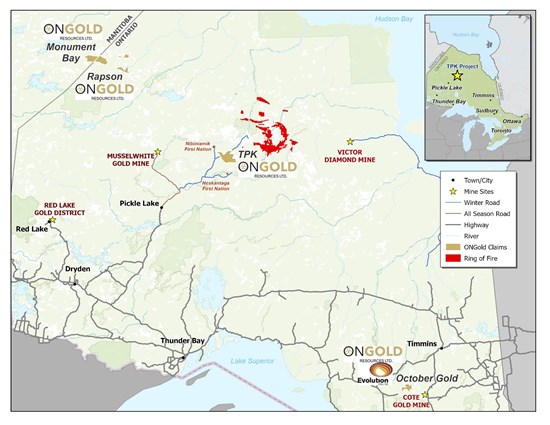
Figure 1: Location Map of the TPK Property in Northern Ontario.
To view an enhanced version of this graphic, please visit:
https://images.newsfilecorp.com/files/10770/280570_b0cc8b3544d7a848_001full.jpg
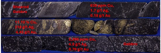
Figure 2: Chalcopyrite Mineralization and Wallrock; Drill Hole GR-25-012 (318.5m to 320.0 m).
To view an enhanced version of this graphic, please visit:
https://images.newsfilecorp.com/files/10770/280570_b0cc8b3544d7a848_002full.jpg
Table 1: Newest Copper and Silver Assay Returns: Fall 2025 Drilling Program.
| Hole | From (m) | To (m) | Length (m) | Au (g/t) | Ag (g/t) | Cu (ppm) | Cu (%) | Zone |
| GR-25-011 | 10.7 | 20.0 | 9.4 | 17.12 | 0.9 | 46 |
| Discovery |
| Including | 11.8 | 20.0 | 8.2 | 19.39 | 1.0 | 47 |
|
|
| including | 11.8 | 12.1 | 0.3 | 308 | 14.6 | 5 |
|
|
| including | 12.1 | 12.8 | 0.7 | 24.80 | 2.1 | 2 |
|
|
| including | 17.0 | 18.5 | 1.5 | 12.20 | 0.7 | 32 |
|
|
| including | 18.5 | 20.0 | 1.5 | 20.10 | 0.4 | 97 |
|
|
| GR-25-012 | 149.2 | 149.7 | 0.5 | 0.73 | 23.4 | 7,850 | 0.79% |
|
| and | 206.0 | 262.4 | 56.4 | 0.30 | 1.6 | 155 |
| West Discovery |
| including | 208.0 | 213.9 | 5.9 | 1.25 | 5.4 | 265 |
|
| including | 208.0 | 209.6 | 1.6 | 2.24 | 3.9 | 113 |
|
| and | 212.7 | 213.9 | 1.2 | 2.08 | 19.9 | 923 | 0.09% |
|
| and | 318.5 | 320.0 | 1.5 | 1.50 | 60.3 | 30,563 | 3.06% | West Discovery Copper |
| including | 319.2 | 319.6 | 0.4 | 4.45 | 218 | 111,000 | 11.10% |
| GR-25-013 | 154.0 | 155.0 | 1.0 | 0.28 | 2.1 | 868 | 0.09% |
|
| and | 157.8 | 158.1 | 0.3 | 1.79 | 42.4 | 29,500 | 2.95% |
|
| and | 217.7 | 222.1 | 4.4 | 0.10 | 2.4 | 1,559 | 0.16% |
|
| and | 294.6 | 295.0 | 0.4 | 0.97 | 20.6 | 9,640 | 0.96% | West Discovery Copper |
| GR-25-014 | 200.5 | 202.0 | 1.5 | 5.21 | 0.6 | 18 |
|
|
| GR-25-015 | 203.0 | 205.0 | 2.0 | 2.00 | 0.4 | 87 |
|
|
| including | 203.0 | 204.0 | 1.0 | 3.47 | 0.4 | 52 |
|
|
| GR-25-016 |
|
|
| NSA | NSA | NSA |
|
|
Notes: - NSA = No Significant Assays
- Holes GR-25-008, GR-25-009, and GR-25-010 returned no significant silver or copper mineralization. Gold assays for these holes were reported Nov. 4, 2025 (see ONGold news release November 4, 2025).
- True widths of mineralized intersections are not known at this time.
|
Table 2: Gold Ridge 2025 Drilling Program.
| Drillhole Name | Easting | Northing | Elevation | Azimuth | Dip | Length (m) |
| GR-25-008 | 432130 | 5823230 | 276 | 350 | 45 | 311 |
| GR-25-009 | 432055 | 5823323 | 272 | 170 | 86 | 110 |
| GR-25-010 | 432055 | 5823323 | 272 | 170 | 75 | 98 |
| GR-25-011 | 432055 | 5823323 | 272 | 170 | 50 | 80 |
| GR-25-012 | 430555 | 5822840 | 260 | 350 | 47 | 329 |
| GR-25-013 | 430555 | 5822840 | 260 | 20 | 47 | 329 |
| GR-25-014 | 432321 | 5824301 | 260 | 300 | 47 | 305 |
| GR-25-015 | 432321 | 5824301 | 270 | 120 | 45 | 305 |
| GR-25-016 | 433941 | 5823764 | 270 | 360 | 47 | 302 |
Property Geology
The TPK Property is located in the Mameigwess greenstone belt of Oxford-Stull domain of the Sachigo Superterrane. The Stull-Wunnumin Fault Zone ("SWFZ") is a regional-scale structure that forms the boundary between the Oxford-Stull terrane and the North Caribou terrane. Bedrock outcrops are sparse, resulting in geophysics and drift prospecting being important tools to identify exploration targets.
In the Gold Ridge area rocks mapped as mafic, and felsic volcanics and interbedded sediments have been intruded by early gabbro and quartz diorite/granodiorite complexes. The intrusions were in turn intruded by early mafic dykes (now often seen as chloritic shears) before being deformed.
Mineralization throughout the Gold Ridge area is controlled by shears in the intrusive rocks and consists of quartz veins and stringers, accompanied by disseminated pyrite, pyrrhotite and local chalcopyrite in chlorite-biotite alteration and local silicification. A 400m X 1,400m, north-northeast trending structural corridor within the diorite, interpreted from magnetics data, is supported by observations made during the recent mapping campaign and core logging.
The property hosts two large independent mineralized systems (Gold Ridge and Big Dam) and is comprised of 2,835 claims covering an area of 76,292 hectares within a highly favorable geological setting. The Gold Ridge area, the focus of this current drilling program, occurs at the head of a large gold grains-in-till dispersal corridor (Keeley Lake gold dispersion train) and is situated in the northern portion of the expansive TPK property (Figure 3).
West Discovery Copper-Silver-Gold Zone
GR-25-012 intersected a weak shear in gabbro which was biotized, weakly silicified and contains disseminated pyrite and chalcopyrite from 314.2 m to 319.15 m. A vein from 319.15 m to 319.55 m (0.4 m) contains a visually estimated 35% chalcopyrite. Values from this zone averaged 1.50 g/t Au, 60.3 g/t Ag and 3.06% Cu over a core length of 1.5 metres from 318.5 m to 320.0 m (including 4.45 g/t Au, 218 g/t Ag and 11.10% Cu over 0.4 metre from 319.2 m to 319.6 m); approximately 225 m from surface. Oriented core measurements indicate this zone trends west-northwest and dips steeply to the south (see Figure 3; red dashed line).
GR-25-013 was drilled to intersect the copper rich zone encountered by hole GR-25-012 110 metres to the west. Values of 1.79 g/t Au, 42.4 g/t Ag and 2.95% Cu, over 0.3 metre were obtained from 157.8 m to 158.1 m from a small quartz-chalcopyrite vein. Further downhole, a siliceous zone with chalcopyrite and pyrite yielded 0.97 g/t Au, 20.6 g/t Ag and 0.96% Cu over 0.4 m from 294.6 m to 295.0 m and appears to correlate on strike with the massive copper sulphide intersection from 319.15 to 319.55 in hole GR-25-012 (see Figure 3).
West Discovery Gold Zone (Qtz-Py-Aspy Vein System)
Hole GR-25-012 was drilled near an Induced Polarization anomaly, up-ice of an historical till sample containing 157 pristine gold grains and historical grab samples of angular boulders which assayed, 5.93 g/t Au, 53.7 g/t Ag, 1.92% Cu, 3.37 g/t Au, 46 g/t Ag, 2.35% Cu and 2.13 g/t Au, 37.7 g/t Ag and 1.45% Cu, respectively (see ONGold news release September 4, 2025). The hole intersected a zone of quartz veining, local silicification, disseminated pyrite, pyrrhotite, arsenopyrite and chalcopyrite hosted in altered diorite and gabbro which assayed 0.30 g/t Au and 1.6 g/t Ag over 56.4 metres from 206.0 m to 262.4 m (including 1.25 g/t Au and 5.4 g/t Ag over 5.9 metres from 208.0 m to 213.9 m in a zone consisting of 70% quartz, including 2.24 g/t Au and 3.9 g/t Ag over 1.6 metres from 208.0 m to 209.6 m and 2.08 g/t Au, 19.9 g/t Ag and 923 ppm Cu over 1.2 metres from 212.7 m to 213.9 m) See Figure 4, orange dashed line, a west-dipping, northeast trending shear zone and vein structure.
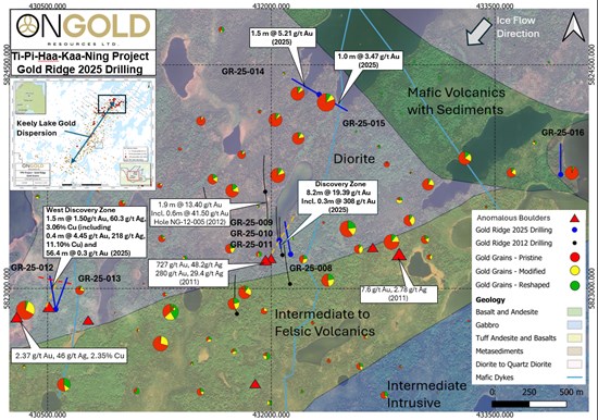
Figure 3: Historical Gold Grains in Till Results, Interpreted Geology, Historical/Recent Drilling, Gold Ridge Area. Blue holes = 2025 drilling, Black holes = 2012 drilling.
To view an enhanced version of this graphic, please visit:
https://images.newsfilecorp.com/files/10770/280570_b0cc8b3544d7a848_003full.jpg
Discovery Zone
The Discovery Zone continues to be the most significant gold intersection return of the 2025 drilling program. GR-25-011 returned a near surface intercept of 19.39 g/t Au over a core length of 8.2 m (11.8 to 20.0m) within a quartz veined structure which strikes north-northeast parallel to the similar structure encountered by hole GR-25-012 (see Figure 3; orange dashed line). Low levels of gold, in the 10 ppb to 30 ppb range, are widespread within the diorite in the Discovery Zone area, suggesting a large, pervasively mineralized system.
Discussion
The latest results from the West Discovery Zone indicate an area where many metals have been mobile and deposited in a higher temperature environment. The mineralized intersections are relatively shallow, with the Gold Zone starting less than 150 m from surface and the Copper Zone at approximately 225 m from surface. Both are open in all directions. The fact that significant gold, silver and copper values are present over 1,500 metres from the Discovery Zone with no drilling between is very encouraging.
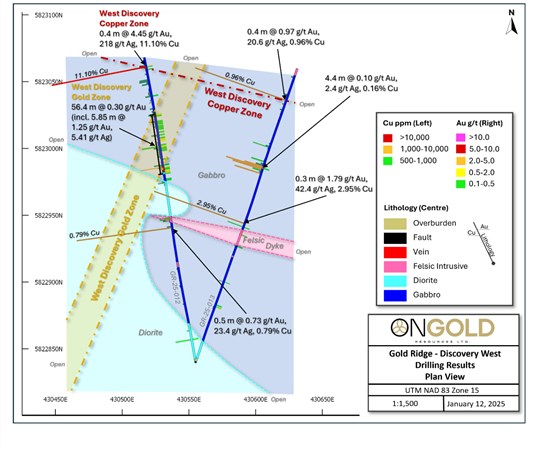
Figure 4: Interpreted Geology of the West Discovery Zone Area. Drill holes coloured by lithology, Gold Assays >0.10 g/t Au shown right of hole trace, Copper assays (left of hole trace) shown as histograms truncated at 5,000 ppm Cu.
To view an enhanced version of this graphic, please visit:
https://images.newsfilecorp.com/files/10770/280570_b0cc8b3544d7a848_004full.jpg
Both areas are interpreted to indicate the presence of a large, intrusive-hosted, orogenic gold system or systems. In the West Discovery area, gold-copper-silver mineralization is hosted in west-northwest trending veins, while the gold bearing quartz-pyrite-arsenopyrite vein appears to trend north-northeast. Temporal relationships between these two systems are not known currently. A series of parallel west-northwest trending structures are interpreted from historical magnetometer surveys to extend well to the east, cutting the mafic to intermediate volcanic sequence. These structures and their intersections with contacts and north-northeast trending shears represent compelling grassroots exploration targets.
Steps Moving forward
To advance exploration on the TPK property ONGold intends to permit and conduct various work programs including:
- A ground electromagnetic and gravity survey over the West Discovery Zone, to attempt to identify extensions of the "Copper Zone" and possible structural controls of the gold/copper mineralization.
- A gravity survey will be completed over the Discovery Zone to better define structure and geology.
- Geological and structural geology compilations are planned for the Gold Ridge and Big Dam areas, as well the recently staked claims.
- Field exploration programs including additional till sampling, mapping, prospecting, historical core re-logging, and soil orientation surveys are planned in the Gold Ridge, New Growth and Big Dam areas.
- Further drill testing of the Discovery, West Discovery and Big Dam areas, as well as priority targets as may be identified by the field programs.
Qualified Person
The scientific and technical content of this press release has been reviewed and approved by Rodney Barber, P. Geo. for ONGold, who is a "Qualified Person" as defined by National Instrument 43-101 - Standards of Disclosure in Mineral Projects. Mr. Barber is the President of ONGold and is not considered independent. Ongoing verification of scientific and technical information is achieved by direct involvement in the exploration work.
QA/QC and Assay Procedures
Quality Assurance/ Quality Control ("QA/QC") procedures were executed to ensure all work is conducted in accordance with best practices. Drill core was cut in half with one half of the core prepared for shipment and the other half retained for future verification. Samples were placed into security-sealed bags for shipment. Drill core is BQTK size and sample intervals range from 0.3 metres to 1.5 metres in length. Commercially prepared certified reference material standards and blanks were inserted at a rate of 1 QA/QC sample in every 10 core samples.
Samples were analyzed at Activation Laboratories facility in Thunder Bay, Ontario and Ancaster, Ontario which are ISO 17025 and ISO 9001 certified. Samples were initially analyzed by 50-gram fire assay with atomic absorption finish. Any sample assaying greater than 5 g/t Au was re-assayed by fire assay gravimetric analysis. Selected samples have been analyzed by screened metallics method.
Geochemical analyses were performed by Activation Laboratories and consists of aqua regia digestion and analyses for 38 elements by ICP. Overlimit samples are re-assayed for silver and copper by Aqua Regia digestion using Inductively Coupled Plasma Optical Emission Spectroscopy ("ICP-OES"), Actlabs code "8 - AR - ICP-OES". A 0.5g sample is digested in aqua regia and diluted volumetrically to 250 ml with 18 megaohm water. Certified reference materials for the appropriate elements are digested the same way and are used as a verification standard(s). Samples are analyzed on an ICP-OES.
About ONGold Resources Ltd.
ONGold Resources Ltd. owns significant exploration assets in Northern Ontario and Northern Manitoba, including the district-scale Monument Bay Gold and Tungsten Project, TPK Project, Domain Gold Project and October Gold Project. These projects represent a strategic footprint in one of Canada's most prolific gold-producing regions.
With its extensive technical expertise, strong commitment to social acceptability, mindful Indigenous engagement and partnerships, in addition to a proven track record of responsible exploration, ONGold's team is uniquely positioned to unlock the full potential of its portfolio of projects.
ONGold Resources Ltd. on behalf of the Board of Directors,
Kyle Stanfield, Chief Executive Officer & Director
Neither the TSX Venture Exchange nor its Regulation Services Provider (as that term is defined in the policies of the TSX Venture Exchange) accepts responsibility for the adequacy or accuracy of this release.
Cautionary Note Regarding Forward-Looking Information:
This news release contains "forward-looking information" within the meaning of applicable Canadian securities legislation. Forward-looking information includes, but is not limited to, statements regarding the Company's future exploration and development plans, the potential for mineralization, and the timing and scope of future exploration activities. Generally, forward-looking information can be identified by the use of forward-looking terminology such as "plans," "expects," "is expected," "budget," "scheduled," "estimates," "forecasts," "intends," "anticipates," or "believes," or variations of such words and phrases or statements that certain actions, events or results "may," "could," "would," "might," or "will be taken," "occur," or "be achieved."
Forward-looking information is based on the Company's reasonable assumptions, estimates, expectations, analyses and opinions at the date the information is provided, and is subject to known and unknown risks, uncertainties and other factors that may cause the actual results, level of activity, performance or achievements of the Company to be materially different from those expressed or implied by such forward-looking information. These risks and uncertainties include, but are not limited to, exploration risks, commodity price volatility, regulatory risks, environmental risks, and other risks associated with the resource exploration and development industry.
Readers are cautioned not to place undue reliance on forward-looking information. The Company undertakes no obligation to update or revise any forward-looking information, whether as a result of new information, future events or otherwise, except as required by applicable law.

To view the source version of this press release, please visit https://www.newsfilecorp.com/release/280570

© 2026 Canjex Publishing Ltd. All rights reserved.