Highlights of Press Release
Soil Geochemistry and Soil Gas Hydrocarbon (SGH) results at Dawn Gulch
- The presence of an alteration halo overlying an extensive buried mineral deposit is demonstrated by elevated anomalous and enhanced metals in soil with linear patterns and broad areal patterns. This all suggests a combination of both high and low-grade gold mineralization.
- The strong SGH redox cell is indicative of a robust buried metal deposit. The SGH results for gold indicate that the gold is present at depth. a higher probability of a gold enriched buried deposit than a base metal enriched deposit. SGH results for base metals also raise the possibility of a polymetallic deposit.
- Soil geochemistry defines linear anomalies and broad areas of anomalous and enhanced values are highly suggestive of epizonal veining and/or enrichment and are related to Reduced Intrusive Related Gold Systems (RIRGS) in the case of gold and RIRBMS in the case of base metals.
High Quality Airborne Magnetics
- An 810 sq. km. magnetic low on the Analytical Signal (AnSig) magnetic plot associated with a strong redox cell, polymetallic soil anomalies and gold and base metal SGH anomalies indicate that the Dawn Gulch gold ± base metal mineralization is locally related to a small off-shot from a larger intrusion.
Projection of the Results from Dawn Gulch
- The four drill-ready prospects within the AGT are presently focused on epizonal vein targets.
- These prospects more probably contain epizonal vein and classic RIRGS targets.
- Much of the south-central edge of the AGT has potential for RIRGS.
- The potential for a mining camp within the Anderson Gold Trend has dramatically increased.
Ottawa, Ontario--(Newsfile Corp. - March 2, 2026) - Mayo Lake Minerals Inc. (CSE: MLKM) (Company or Mayo) is excited to announce the results from last fall's geochemical and SGH soil sampling at Dawn Gulch and their interpretation. Dawn Gulch is located south of Mayo Lake at the northwestern end of the 48 sq. km. Anderson Gold Trend (Fig. 1) and some 15 km to the southeast of Banyan Gold's AurMac project. which hosts pit-constrained Indicated resources of 2.27 M oz Au (112M t at 0.63 g /t) and Inferred resources of 5.45 Moz Au (260.0M t at 0.60 g/t) [1] within a Reduced Intrusion Related Gold System (RIRGS).
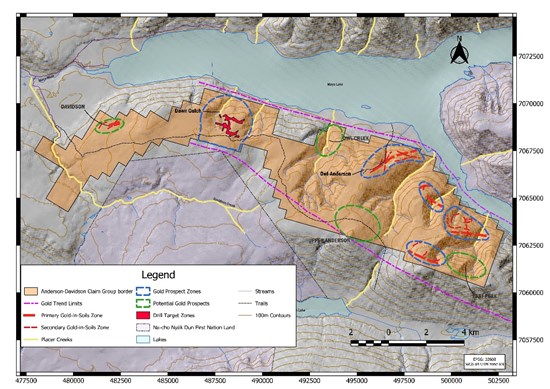
Figure 1. The Anderson-Davidson property and the Anderson Gold Trend with gold prospects.
To view an enhanced version of this graphic, please visit:
https://images.newsfilecorp.com/files/5471/285804_945d520734656bcd_002full.jpg
Dr. Vern Rampton, CEO, President, and Chairman of Mayo commented, "The information that we have obtained from geochemical analysis of soil samples, gold by both INAA- fire assay and, Aqua Regia-MS and a SGH study that identified a strong Redox cell over an AnSig mag low has clearly defined a drillable RIRGS target. The SGH study also evidenced highly rated determination of the presence of gold at depth and a moderately rated determination of the presence of base metals at depth. This has also allowed us to confidently model a RIRGS target, with possible base metal components at Dawn Gulch. It doesn't appear to be much different from the geological features at Banyan Gold's AurMac deposit or Victoria Gold's Eagle mine, perhaps not in size. But that may not matter if the findings at Dawn Gulch can be extrapolated over the 48 sg.km Anderson Gold Trend (AGT). It is our opinion that with success from the drilling of present and future identified drill targets that we will probably be on our way towards the eventual development of a gold mining camp within the AGT. To be clear, drill targets are only designated if soil geochemistry, geophysical or geological surveys or a combination thereof support such designation. This development within the AGT would nicely complement the potential at Mayo's Carlin West high-grade silver prospect."
Dawn Gulch Results
Dawn Gulch was targeted because of its long history of placer gold production. Mayo's soil sampling program was restricted to a smaller area than originally planned because of the onset of severe fall weather conditions The location of the smaller than originally planned, sample grid was positioned over an Analytical Signal (AnSig) mag low. The smaller grid was intentionally located at a likely source area near the up-stream extent of multi-decade placer mining in the area.
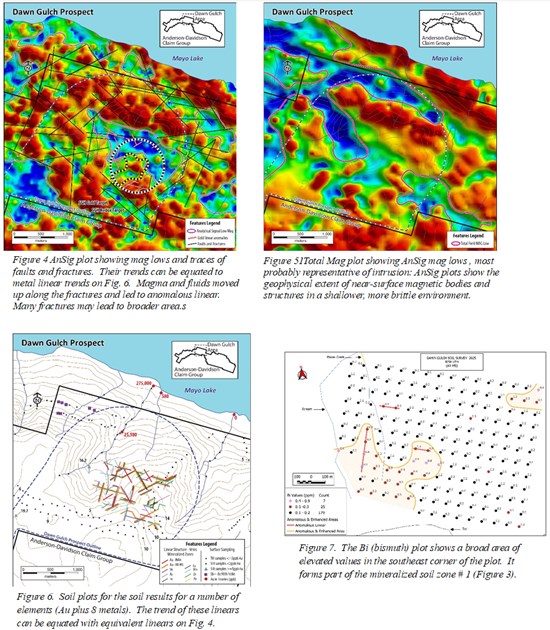
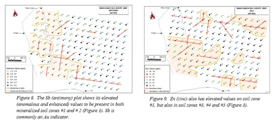
The presence of a robust Soil Gas Hydrocarbon (SGH) redox cell along with a highly rated SGH gold target indicates the high probability of a significant gold deposit extending to some depth (grade and exact location are difficult to determine with SGH). Soil plots for gold and bismuth plus some other metals that run with gold indicate that gold occurs in both high-grade linear types of deposits such as veins and plates of highly mineralized rock and as larger low-grade bulk tonnage deposits consisting of gold in a disseminated form or within narrow sheeted veining. The possibility of low-grade deposits is supported by the evidence for very extensive fracturing of brittle rock in the northern part of the Tombstone Gold (Plutonic) Belt (Schedule Two; Figs. 4 and 6). The SGH results supported by anomalous and enhanced values in soil also indicate that base metal deposits cannot be ruled out. Banyan Gold eventually realized that its RIRGS had a base metal component, admittingly high in silver, at AurMac. The situation at Victoria's Gold Eagle mine is similar. These polymetallic soil zones (Fig. 3; Schedule Two, Fig. 9), both the anomalous linears and the broader areas are marked by sharp boundaries. Similar to the probable gold deposits at Dawn Gulch, the apex of these base metal deposits is probably located near the source of the SGH redox cell at some depth. The underlying AnSig mag low could represent a small out-shoot from a larger intrusion (Schedule 2; Figs. 4 and 5).
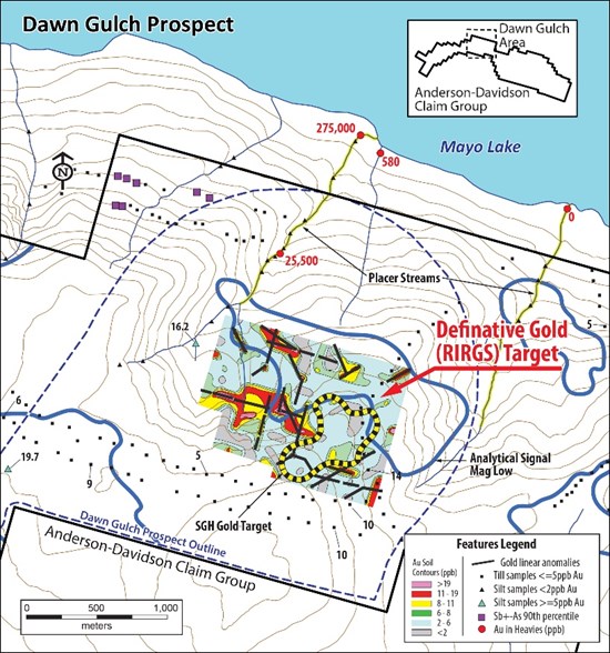
Figure 2. Gold in soil (analyzed by INAA) contours showing broad elevated (above background) areas; linears from soil samples (analyzed by INAA and Aqua Regia-MS); SGH gold target; and Analytical Signa mag low. The broad areas may represent similar zones in the underlying rock. The linears may represent veins or plates of rock with disseminated mineralization or a multitude of thinnish veins.
To view an enhanced version of this graphic, please visit:
https://images.newsfilecorp.com/files/5471/285804_945d520734656bcd_003full.jpg
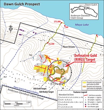
Figure 3. Areas consisting of anomalous and enhanced gold in soils; anomalous gold linears (Au as determined by INAA and Aqua Regia - MS); soil zones consisting of multiple metals; redox cell as determined by SGH; and SGH gold target at depth.
To view an enhanced version of this graphic, please visit:
https://images.newsfilecorp.com/files/5471/285804_945d520734656bcd_004full.jpg
Tombstone Gold (Plutonic Belt) (TGB)- Geology
The TGB is highly fractured and faulted due to multiple thrusts and movement of metasediments, some hundreds of kms to the north in a brittle environment[2]. The linear veins and plates, generally steeply dipping, for gold and numerous other elements are related to faults and fractures as can be observed in (Schedule 2, Fig. 6). The anomalous and enhanced values for gold and other metals in soils over broader areas probably result from upward movement of gases and fluids along specific fractures in the underlying highly fractured rock. Fractures are probably more numerous than those recorded on Schedule 2, Fig. 4. In reality many of these metals will not be present in sufficient quantities in the rock to be mineable. Note that the edge of anomalous and enhanced analytical results is sharply elevated relative to the surrounding areas with very low values (background). The values are simply elevated above background in the soils.
Projections to the Anderson Gold Trend.
The implications of our findings at Dawn Gulch are formative to the AGT's potential. Dawn Gulch was sampled at this late date because earlier reconnaissance sampling yielded higher gold values in the eastern part of the AGT (Fig. 1 from press release dated July 21, 2014). Reconnaissance sampling at Dawn Gulch and along much of the plateau along the south part of the AGT contains few anomalous samples with those returning values commonly in the 5-10 ppb Au range, nothing outstanding.
Mayo's previously delineated drill targets (four) are focused on elevated gold linears, commonly associated with mag lows. These elevated gold linears may also be related to a RIRGS. Many of the long broad magnetic lows have been attributed to stratigraphy and structure, but they could be buried reduced intrusions with similar shapes. Magnetic lows with similar shapes are known to be intrusions as is the case on Banyan Gold's newly acquired Trail-Minto property where the intrusions outcrop. Barrie[3] noted sheared felsic intrusives near Owl Creek that had been previously mapped as sheared conglomerate. He also noted veins high in silver, lead and zinc are to the east of Owl Creek. RC drilling yielded 0.9 Au/t over 3.1m, extending to 0.8g Au/t over 6.1m, at the Owl-Anderson prospect with the drills being collared in mineralization. These grades are common to sheeted veining. Further, much of the terrain on the upper plateau forming the south edge of the AGT shows a multitude of 5-10 ppb soil samples and samples containing 90 percentiles of Au ± Sb ± Ag. A review of the airborne magnetics and further soil sampling is warranted in this section of the AGT.
The findings at Dawn Gulch are supportive of a gold mining camp developing within the AGT. If some of the prospects presently outlined in Figure 1 were to result in the discovery of economic epizonal (mesothermal-epithermal) veins and more classic RIRGS deposits, we would be well on the way to developing a significant gold resource within the AGT. At this stage however, there can be no guarantee that extensive economic mineralization will be found.
Anderson Gold Trend (AGT); 8 Prospects
Eight prospects have been identified in the AGT after review of reconnaissance geochemical soil sampling and from the interpretation of high-quality airborne magnetics. Follow-up soil sampling (press releases dated May 22 and October 25, 2022) indicates potentially high-grade vein systems. Four of the prospects have now been identified as being drill ready. High quality airborne magnetics suggest that theses vein systems are related to covered intrusions. Recent results from Dawn Gulch suggest that RIRGS (or that of base metals) are present within and beyond the defined vein systems.
Dawn Gulch - four zones. A 1,500m long zone consisting of gold linears with gold values common to 49m was identified. Three other linear zones totalling 2,000m in length with gold values up to 151 ppb Au were also noted. In addition, one broad 210 sq. km. enhanced gold in soil mineralized system was delineated. SGH has identified potential gold (and base metal) mineralization at depth. This mineralization may be a RIRGS as evidenced by an AnSig mag low.
Anderson-Owl - four zones. A 3,000m long linear zone consisting of intermittent gold in soil anomalies totalling 3,000m in length and marked by gold values up to 527ppb Au. Three other zones total 1,080m in length with gold values to 101ppb Au. Gold was identified in the subsequent RC drilling program.
Anderson-Owl - 640m RC drill program. A structure was intercepted that was continuous along strike for 50m, but open in all directions. The width and grade of the gold mineralization has not been determined because both holes were collared in mineralization. One hole yielded 0.77g Au/t over 0.55gAu/t, inc. 0.9g Au/t over 3.1m; a second along strike assayed 0.55g Au/t over 3.1 m. The drilled structure consisted of quartz-sulfide veins containing stibnite, arsenopyrite, pyrite, and silica-cemented breccia with strong Au-As-Sb-Hg geochemical signatures; possible sheeted veining related to a RIRGS.
Peak - six zones. A 1,600m long zone with gold values up to 272ppb Au. Four other zones total 2,630 in length with gold values up to 340ppb Au.
Steep Creek - Six zones. A 1,700m long zone with gold values up to 142ppb Au. Five other zones totalling 2,240m in length with gold values up to 140ppb Au.
Norman- Two zones. Nearly 1,270m of anomalies are marked by gold values up to 87ppb Au. The soil geochemistry and AnSig and Total mag for all the AGT prospects will be reviewed prior to prioritizing drilling.
Regional Context: Tombstone Gold Belt and Mayo-Keno area.
The Mayo-Keno area lies within the Tombstone Gold Belt (TGB), a prolific corridor hosting intrusion-related and epizonal mineralized systems, most probably all Reduced Intrusion-Related Gold Systems (RIRGS), (high-grade gold and silver and/or polymetallic vein systems). The Mayo-Keno region is currently buzzing with activity as a result of the recent discoveries that have propelled the TGB into the spotlight. Those discoveries and resource expansions across the district have increased exploration activity and investor interest.in the TGB. Notable resources include:
- Banyan Gold: AurMac deposit with reported pit-constrained Indicated resources of 2.27 M oz Au (112M t at 0.63 g /t) and Inferred resources of 5.45 Moz Au (260.0M t at 0.60 g/t).1
- Sitka Gold: Blackjack and Eiger deposits with Indicated resources of 1.29 M oz Au (40.0M t at 1.01 g/t) and Inferred resources of 1.18 M oz Au (612.0M t at 0.75 g/t). [4]
- Victoria Gold: Eagle and Olive deposits with Measured & Indicated resources of 4.66 Moz Au; Raven Deposit with Inferred resources of 1.07 Moz Au (19.9Mt at 0.59 g/t). [5]
- Hecla Mining: Silver. Proven and Probable reserves of 53.4M oz Ag (2.11Mt at 21.1 oz Ag/t); Indicated resources of 14.0M oz Ag (0.58Mt at 24.1 oz Ag/t) plus Inferred resources of 18.2M oz Ag as of December 31, 2024. Production is ongoing at Keno Hill. [6]
- Snowline Gold: Rogue Project; Measured & Indicated resources: 7.44 Moz Au (204M t at 1.21/t) and Inferred resources of 0.89M oz Au (44.5M t at 0.62 g /t). Banyan, Sitka, Snowline and Hecla all have strong market support. Victoria is currently under bankruptcy protection and is now for sale with a restart of full production expected once a purchase is finalized. These district-scale results support continued exploration across the belt and provide geological context for Mayo Lake's 2026 exploration program.[7]
Readers are advised that management cannot positively warrant that similar resources to those quoted above will be discovered and developed at Dawn Gulch or any other of Mayo's prospects, However, management has not encountered any material impediments that would prevent the discovery of a significant resource from one or more of its prospects.
Please See Schedule 2 at End of Press Release for Diagrammatic Detail (Figs-4-9)
Qualified Person. The technical and scientific information contained within this news release has been prepared and approved by Dr. Vern Rampton, P.Eng., a Qualified Person as defined by National Instrument 43-101 - Standard of Disclosure for Mineral Projects ("NI 43-101"). Dr. Rampton is also Mayo's President, CEO and a director.
Closing of Tranche 2 of Private Placement
In other corporate news, the Company has closed the second leg of its previously announced private placement of up to $300,00 consisting of any combination of Common Share (CS) Units and Flow Through Units @ $0.05 per Unit.
Each CS Unit consists of one common share and one-half common share purchase warrant (a "Warrant"). Each whole Warrant is exercisable into one common share at a price of $0.07 for a period of 36 months from the closing date. Each FT Unit consists of one flow-through share (a "FT Share") and one-half common share purchase warrant. Each whole warrant is exercisable into one common share at a price of $0.08 for a period of 36 months from the closing date. Each FT Share will be issued as a "flow-through share" within the meaning of the Income Tax Act.
With the closing of this leg of 950,000 CS Units, for $47,500, the amount raised to date now totals $202, 500.
This second tranche of the offering constituted a related party transaction within the meaning of the Multilateral Instrument 61-101, Protection of Minority Security Holders in Special Transactions, as Auropean Ventures Inc. an insider of the company acquired 800,000 shares. The company is relying on the exemptions from the valuation and minority shareholder approval requirements of MI 61-101 contained in sections 5.5(b) and 5.7(1)(a) of mi 61-101, as the company is not listed on a specified market and the fair market value of the participation in the offering by the insider does not exceed 25 per cent of the market capitalization of the company in accordance with MI 61-101.
These CS Unit funds will primarily be used to cover working capital and general operating costs whereas FT Unit funds will be used for eligible exploration expenditures qualifying as "CEE" under the Income Tax Act and applicable regulations. The securities issued pursuant to the Offering will be subject to a statutory hold period in Canada of four (4) months and one day after the Closing Date. The placement is subject to the approval of the Canadian Securities Exchange.
Mayo also provides notice that a total of 1,716,700 common share purchase warrants exercisable at $0.10 per share and 17,500 finder unit warrants (FUW) exercisable @ $0.06 per Unit (each FUW contains one common share and one warrant exercisable @ $0.10 per share) are also set to expire on March 31 of this year. Furthermore, a total of 1,275,000 Restricted Share Units granted on September 30, 2025 as announced in Mayo's press release of the same date will become vested on March 31.
About Mayo Lake Minerals Inc. (Mayo)
Mayo is actively engaged in the exploration, discovery and development of three precious metal properties covering 145.6 square kilometres in the Mayo- Keno area of the Mayo Mining District. All properties lie within the traditional territory of the Na-Cho Nyäk Dun First Nation. The Mayo-Keno area lies within the Tombstone Gold Belt, where Reduced Intrusion Related Gold Deposits are attracting exploration and mine development, witness Victoria Gold's Eagle gold mine, Hecla Mining's silver mines at Keno and projects being actively moved forward toward mine development by Banyan Gold, Sitka Gold, and Snowline Gold.
Mayo's Carlin-Roop Silver property is 44 sq.km. in size with evidence suggesting the presence of high-grade silver common to the Keno Hill Silver District. Its Carlin West zone has the same footprint and similar characteristics to the Elsa Mine, which produced 30M ounces of silver at 128 ounces Ag/ton. Mayo's 86 sq, km. Anderson-Davidson property has produced enough positive data to envisage a major mining camp in its Anderson Gold Trend where over 10,000m of linear gold in soil anomalies have been outlined. These anomalies are probably the surface indication of subsurface gold veining. At its diversified multi-metal Edmonton property, a broad magnetic low probably indicates an alteration halo over a buried intrusion. The presence of anomalous gold, silver and base metal geochemical anomalies in combination with positive SGH anomalies could point to a major multi-element deposit.
The Mayo-Keno region is currently buzzing with activity as a result of recent discoveries that have propelled the Tombstone Gold Belt into the spotlight. Readers can access more details on the company's website at https://www.mayolakeminerals.com/.
See Schedule Two For Maps & Diagrams on Pages 8 & 9
Schedule One
Collection, Storage, Shipping, Analysis and Quality Control of Samples
A total of 185 soil samples for geochemical analysis and assaying and 46 soil samples for Soil Gas Hydrocarbon (SGH) analysis were collected by Truepoint Exploration of Vancouver and Coureur Des Bois of Whitehorse on September 20 and 21 of 2025. The totals included 5 duplicates samples for geochemical analysis and 2 duplicates for SGH analysis to check on site variances between samples.
These samples were securely stored at Truepoint Explorations base camp at Keno and transported to Whitehorse where they were then transported by a bonded trucking company to the ActLabs facility at Ancaster, Onario.
At the Actlabs' facility, the samples were catalogued. The samples were then dried at 40ᴼC and sieved at - 177 micron. Fifteen grams of the -177 micron portion were then processed by ICP-MS (Actlabs UT-IM, Au + 34 elements). The remainder of the -177 micron separate was assayed for gold by fire assay - INAA, providing that more than 5g of -177 micron was available (Actlabs 1A1, Au). The majority of the samples assayed had more than 20 grams available for assaying. The results from UT-IM and 1A1 were reported on an excel tables. Approximately 20 elements, including Au by INAA and Au by Aqua Regia-ICP-MS were contoured in a fashion that respects deposit morphologies in a brittle rock fractured environment.
For purpose of quality control, Actlabs inserted standards and blanks at intervals for both the UT-IM and 1A1 analysis.
Most results from the 1A1 were significantly higher than those from the UT-IM analysis most probably due to the inability of aqua regia to dissolve gold encapsulated in silica or other resistant minerals. Occasionally a result from the UT-IM would match or exceed that of the 1A1.
The samples collected for SGH analysis were also dried at 40ᴼ and sieved at -177 microns an aqueous leach is used to extract the hydrocarbons from the sample. The sample extracts are analyzed by a High Resolution Gas Chromatograph/Mass Spectrometer (HEGC/MS) to a reporting limit of 1 part per trillion (1 ppt). These are reported on an excel spreadsheet plus a contoured diagram of the results indicative of different metals or combinations. Hydrocarbon compound classes are utilized to identify the metal target(s) and to position it.
For SGH quality control laboratory replicates and blanks are also analyzed.
Schedule Two
To view an enhanced version of this graphic, please visit:
https://images.newsfilecorp.com/files/5471/285804_321c454284467bda_001full.jpg
To view an enhanced version of this graphic, please visit:
https://images.newsfilecorp.com/files/5471/285804_27c62af684642bb7_001full.jpg
NOT TO BE DISTRIBUTED TO NEWS WIRE SERVICES OR DISSEMINATED IN THE UNITED STATES
Cautionary Statement Regarding Forward-Looking Information. This news release contains forward-looking statements and forward-looking information within the meaning of applicable securities laws. These statements relate to future events or future performance. All statements other than statements of historical fact may be forward-looking statements or information. The forward-looking statements and information are based on certain key expectations and assumptions made by management of Mayo. Although management of Mayo believe that the expectations and assumptions on which such forward-looking statements and information are based are reasonable, undue reliance should not be placed on the forward-looking statements and information since no assurance can be given that they will prove to be correct. Forward-looking statements and information are provided for the purpose of providing information about the current expectations and plans of management of Mayo relating to the future. Readers are cautioned that reliance on such statements and information may not be appropriate for other purposes, such as making investment decisions. Since forward-looking statements and information address future events and conditions, by their very nature, they involve inherent risks and uncertainties. Actual results could differ materially from those currently anticipated due to a number of factors and risks. Accordingly, readers should not place undue reliance on the forward-looking statements and information contained in this news release.
The forward-looking statements and information contained in this news release are made as of the date hereof and no undertaking is given to update publicly or revise any forward-looking statements or information, whether as a result of new information, future events or otherwise, unless so required by applicable.
END OF PRESS RELEASE
1 Technical Report, AurMac Property, Mayo Mining District, Yukon Territory, Canada, effective date August 20, 2025; prepared by Marc Jutras, P.Eng. Ginto Consulting Services Inc., Tysen Hantelmann, P. Eng., of JDS Energy and Mining Inc. and Deepak Malhotra, Ph.D. of Forte Dynamics).
2 Gabrielse, H., Murphy, D.C., and Mortensen, J.K. 2006 Cretaceous and Cenozoic orogen parallel displacements, magnlosm and paleogeography, north-central Canadian Cordillera, Geological Association of Canada Signed Paper 46, p. 85-276
3 Barrie, C.T. 2017. Technical Report on the Mineral Exploration and Mineral Potential of the Anderson-Davidson Claim Group, Mayo Mining District, Yukon Territory, Canada. Mayo Lake Minerals web-site and Sedar.
4 Clear Creek Property, RC Gold Project, NI 43-101 Technical Report, Dawson Mining district, Yukon Territory, effective date January 21, 2025; prepared; by Ronald G. Simpson, P. Geo, of GeoSim Services Inc
5 Technical Report for the Eagle Gold Mine, Yukon Territory, Canada, effective date - December 31, 2022; prepared by Nico Harvey, P. Eng., Paul Gray, P. Geo., Jeff Winterton, P.E., all of Victoria Gold; Marc Jutras, P. Eng., of Ginto Consulting Inc., and Michael Levy, P.E. of JDS Energy & Mining Inc.
6 Hecla Mining, Annual Report, December 31, 2025.
7 Independent Preliminary Economic assessment for the Rogue Project Yukon, Canada on August 27, 2025; prepared by Robert McCarthy, P.Eng., Edward Saunders, P. Eng., Ignacio Garcia Schmidt, P.Eng., Mauricio Herrera, P.Eng., Megan Miller, P. Eng., Soren Jensen, P.Eng., Jeff Clarke, P. Geo., Adrian Dance, P. Eng., Heather Burrell, P. Geo., Steven C. Haggarty, P.Eng., Daniel Redmond, P. Geo. of SRK Consulting (Canada) Inc.

To view the source version of this press release, please visit https://www.newsfilecorp.com/release/285804

© 2026 Canjex Publishing Ltd. All rights reserved.