Vancouver, British Columbia--(Newsfile Corp. - April 30, 2026) - Homeland Uranium Corp. (TSXV: HLU) (OTCQB: HLUCF) (FSE: D3U) ("Homeland" or the "Company") reports the first tranche of geochemical assay results from its recently completed Phase II exploration drilling program at the 100%-owned Coyote Basin Uranium Project (the "Project") (Figure 1).
Geochemical assay results have been received for eight of the thirty-three drillholes (not including one lost hole) completed during the Phase II program: CB-RC-0025, CB-RC-0026, CB-RC-0027, CB-RC-0028, CB-RC-0029, CB-RC-0030, CB-RC-0031, and CB-RC-0032 (see Table 1 below). All eight holes are located in the northern portion of the Southern Drill Area (Figure 2). All analyzed samples from each drill hole returned uranium concentrations of less than or equal to 30 parts per million ("ppm") U. Samples were collected from drill cuttings obtained from within the zones of elevated radioactivity identified through downhole spectral gamma ray probing. These geochemical results are lower than initially anticipated based on radiometric response. Geochemical results from the remaining twenty-four holes have yet to be received, including those from all holes drilled in the Central Drill Area.
Despite the lower-than-expected uranium concentrations, downhole probe data continues to demonstrate a laterally continuous horizon of elevated and locally anomalous radioactivity within the previously reported near-surface interval. This radiometric continuity, observed across multiple drill fences, suggests that the anomalous horizon remains laterally extensive and warrants further investigation.
As part of its ongoing evaluation, the Company will undertake a review of the sample results and select samples will be submitted to a second independent laboratory to confirm the reported uranium concentrations.
The Company is also evaluating the potential for uranium mineralization to occur in a manner that may not be accurately represented by the current drill hole spacing, including the possibility of localized variability in uranium distribution. Future exploration programs will consider this possibility in the design of follow-up drilling and sampling strategies. As part of the re-evaluation, Homeland will consider the merits of follow-up drilling to test deeper mineralized horizons situated below the currently drill defined horizon of anomalous radioactivity. These deeper horizons were identified in outcrop during both the Phase I program and historical exploration programs that remain underexplored. Homeland's Phase II program was unable to test these deeper horizons as originally planned due to unexpected limitations of the drill contractor's drill equipment and personnel. The radioactive horizons encountered during the Phase II program remain underexplored and only sporadically drill tested over a projected strike length of 10 km north of the Central Drill Area and are also believed to extend 7 km south and west of the Northern Drill Area where they have never been drill-tested.
These targets represent an opportunity to further assess the broader mineralization potential of the Project.
During this evaluation period, as Homeland is well capitalized, exploration efforts will shift to the nearby Cross Bones Property, where a recently purchased historical dataset has significantly advanced this project in terms of knowledge, saved significant future exploration costs and time, and is in the process of helping to refine future drill targeting. The Cross Bones Project contains the historical Cross Bones Uranium Deposit (formerly known as the Skull Creek Deposit).
Further updates on the winter drill program at Coyote Basin will be provided as additional analytical results are received and interpreted.
Quality Assurance/Quality Control
All drillholes are radiometrically logged using a calibrated QL40 SGR Spectral Gamma Ray downhole probe, which collects continuous spectral gamma measurements along the length of the drillhole. Gamma values are collected and reported as Counts Per Second. The probe response is calibrated using coefficients derived from the probe's most recent factory calibration and through comparison of probe responses to geochemical assay data from previously sampled intervals.
Spectral gamma tools measure natural radioactivity, and in situations where the uranium decay series is in equilibrium, such gamma readings can be converted into equivalent concentrations of uranium (known as "eU3O8"), thorium, and potassium. However, if the uranium decay series is not in equilibrium, conversion of spectral gamma into equivalent concentrations of uranium may not be accurate, a phenomenon known as uranium disequilibrium. Uranium disequilibrium has been documented to occur at the nearby former producing Maybelle Uranium Mine, located approximately 29 km (18 miles) northeast of the Coyote Basin Project (see Global Uranium & Enrichment's news release dated July 29, 2025 that can be found at https://wcsecure.weblink.com.au/pdf/GUE/02972557.pdf ).
As a first step in determining the accuracy of QL40 SGR Spectral Gamma Ray downhole probe and determining whether uranium disequilibrium may occur at Coyote Basin, Homeland's geological team used a portable hand-held XRF (SciAps X-555 REE Analyzer) to test drill cuttings for the presence of uranium. Enough discrepancies have occurred when comparing the results of the Spectral Gamma Ray downhole probe and the XRF that additional geochemical and assay sampling will be required before uranium grades can be accurately determined.
Homeland collected samples from 5 ft long intervals of the drill holes for geochemical analysis which were sent to SGS Laboratories in Lakefield, Ontario, in secure containment for preparation, processing and multi-element analysis by Sodium Peroxide Fusion and Inductively Coupled Plasma Optical Emission Spectrometry (Na2O2; ICP-OES). Samples were chosen for analysis based on downhole probing radiometric equivalent grades above 0.005 % eU3O8. SGS Lab is certified ISO 17043: General requirements for proficiency testing. Blanks, standard reference materials, and repeats are inserted into the sample stream at regular intervals by HLU and the SGS in accordance with each's respective quality assurance/quality control (QA/QC) procedures. Geochemical assay data are subject to verification procedures by qualified persons employed by HLU prior to disclosure.
All depths and intervals reported are drilled depths and downhole lengths, unless otherwise stated. True thicknesses have not yet been determined.
Table 1: Coyote Basin Drillhole Locations
| Drillhole ID | Dip | UTM
Easting | UTM
Northing | Elevation
(m) | Elevation
(ft) | Final Depth
(m) | Final Depth
(ft) |
| CB-RC-0024 | -90 | 733289 | 4454299 | 1835 | 6020 | 249.9 | 820.0 |
| CB-RC-0025 | -90 | 733088 | 4454299 | 1819 | 5968 | 146.3 | 480.0 |
| CB-RC-0025A | -90 | 733076 | 4454305 | 1811 | 5942 | 365.8 | 1200.0 |
| CB-RC-0026 | -90 | 732892 | 4454300 | 1824 | 5984 | 213.4 | 700.0 |
| CB-RC-0027 | -90 | 732741 | 4454282 | 1833 | 6014 | 170.7 | 560.0 |
| CB-RC-0028 | -90 | 732493 | 4454298 | 1811 | 5942 | 164.6 | 540.0 |
| CB-RC-0029 | -90 | 732492 | 4454102 | 1812 | 5945 | 91.4 | 300.0 |
| CB-RC-0030 | -90 | 732690 | 4454098 | 1820 | 5971 | 109.73 | 360.0 |
| CB-RC-0031 | -90 | 732890 | 4454099 | 1845 | 6053 | 109.73 | 360.0 |
| CB-RC-0032 | -90 | 733094 | 4454101 | 1822 | 5978 | 132.59 | 435.0 |
*All coordinates were collected with a handheld Garmin GPS and displayed in UTM NAD83 Z12N
About Homeland Uranium Corp.
Homeland Uranium is a mineral exploration company focused on becoming a premier US-focused and resource-bearing uranium explorer and developer. The Company is 100% owner of the Coyote Basin and Cross Bones uranium projects in northwestern Colorado.
Qualified Person
Nancy Normore., P.Geo., the Company's Vice President, Exploration, is a Qualified Person as defined in NI 43-101, and has reviewed and approved the technical content of this news release.
Neither the TSX Venture Exchange nor its Regulation Services Provider (as that term is defined in the policies of the TSX Venture Exchange) accepts responsibility for the adequacy or accuracy of this news release.
Forward-Looking Statements
This news release contains "forward-looking statements" within the meaning of applicable securities legislation. Such forward-looking statements in this news release relate to, among other things: the Company's expectation and strategic plans in relation to the exploration of the Company's uranium mineral properties, including all phases of the exploration program at the Projects.
These forward-looking statements reflect the Company's current views with respect to future events and are necessarily based upon a number of assumptions that, while considered reasonable by the Company, are inherently subject to significant operational, business, economic and regulatory uncertainties and contingencies. These assumptions include, among other things: conditions in general economic and financial markets; accuracy of assay results; geological interpretations from drilling results; timing and amount of capital expenditures; performance of available laboratory and other related services; future operating costs; the availability of skilled labour and no labour related disruptions at any of the Company's operations; no unplanned delays or interruptions in scheduled activities; all necessary permits, licenses and regulatory approvals for operations are received in a timely manner; the ability to secure and maintain title and ownership to properties and the surface rights necessary for operations; and the Company's ability to comply with environmental, health and safety laws. The foregoing list of assumptions is not exhaustive.
The Company cautions the reader that forward-looking statements involve known and unknown risks, uncertainties and other factors that may cause actual results and developments to differ materially from those expressed or implied by such forward-looking statements contained in this news release and the Company has made assumptions and estimates based on or related to many of these factors. Such factors include, without limitation: the timing and content of work programs; results of exploration activities and development of mineral properties; the interpretation and uncertainties of drilling results and other geological data; receipt, maintenance and security of permits and mineral property titles; environmental and other regulatory risks; project costs overruns or unanticipated costs and expenses; availability of funds; general market and industry conditions; and those factors identified under the captions "Risks Factors" and "Risks and Uncertainties" in the Company's disclosure materials filed on SEDAR+ at www.sedarplus.ca.
Forward-looking statements are based on the expectations and opinions of the Company's management on the date the statements are made. The assumptions used in the preparation of such statements, although considered reasonable at the time of preparation, may prove to be imprecise and, as such, readers are cautioned not to place undue reliance on these forward-looking statements, which speak only as of the date the statements were made. The Company undertakes no obligation to update or revise any forward-looking statements included in this news release if these beliefs, estimates and opinions or other circumstances should change, except as otherwise required by applicable law.
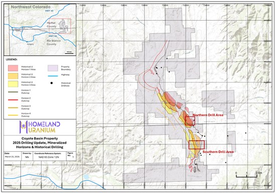
Figure 1: 2025-2026 Coyote Basin Drill Areas
To view an enhanced version of this graphic, please visit:
https://images.newsfilecorp.com/files/10583/295102_dd8f40f1746808d9_002full.jpg
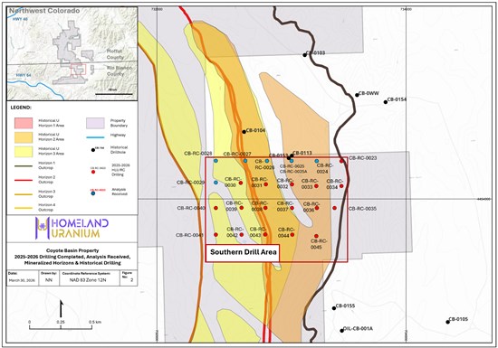
Figure 2: Coyote Basin Southern Drill Area
To view an enhanced version of this graphic, please visit:
https://images.newsfilecorp.com/files/10583/295102_dd8f40f1746808d9_003full.jpg

To view the source version of this press release, please visit https://www.newsfilecorp.com/release/295102

© 2026 Canjex Publishing Ltd. All rights reserved.