VANCOUVER, British Columbia, April 08, 2026 (GLOBE NEWSWIRE) -- Greenridge Exploration Inc. ("Greenridge" or the "Company") (CSE: GXP | OTC: GXPLF | FRA: HW3) is pleased to announce the completion of an integrated 3D multi‑physics inversion and machine‑learning‑assisted lithology modelling program (the “Program”) at its Carpenter Lake Uranium Project (“Carpenter Lake” or the “Project”), located along the Cable Bay Shear Zone (“CBSZ”) on the southern margin of the Athabasca Basin, northern Saskatchewan.
The work was completed by Convolutions Geoscience Corp. (“Convolutions”) in collaboration with Computational Geosciences Inc. (“CGI”), who served as independent inversion specialists and developers of the Geophysics‑Informed Lithology Interpolation (“GILI”) platform (Please see Figure 1).
Russell Starr, CEO of Greenridge stated: “Combining the third-party expertise of the Convolutions and CGI teams has enabled the production of a 3D model of the Carpenter Lake geology, which is an example of our Company’s adoption of advanced exploration technology. The Cable Bay Shear Zone is a complex and highly-prospective structure for hosting uranium mineralization, and the joint inversions and resulting GILI model will bolster our future drill targets across more than 15 kilometres of strike length on the Project.”
Integrated 3D Modelling of Historical VTEM™, Falcon Gravity, and Magnetic Data:
The Program represents the first fully integrated reinterpretation of the Project’s historical airborne datasets, including:
- 2014 versatile time-domain electromagnetic (“VTEM™”) survey;
- 2015 Falcon® Airborne Gravity Gradiometry (“AGG”) survey (all seven tensor components); and
- High‑resolution Total Magnetic Intensity (“TMI”) data.
CGI and Convolutions applied a modern inversion workflow incorporating:
- Parametric plate modelling of VTEM™ conductors;
- Cross‑gradient joint inversion of gravity and electromagnetic (“EM”) datasets;
- 3D lithology model generation using GILI;
- High‑resolution OcTree and tensor meshes;
- Incorporation of Greenridge’s 2025 drilling data and physical property and structural measurements from drill core.
This approach produced 3D physical property models consistent with all available data and a lithology model of the CBSZ corridor, significantly advancing the structural interpretation of the Project.
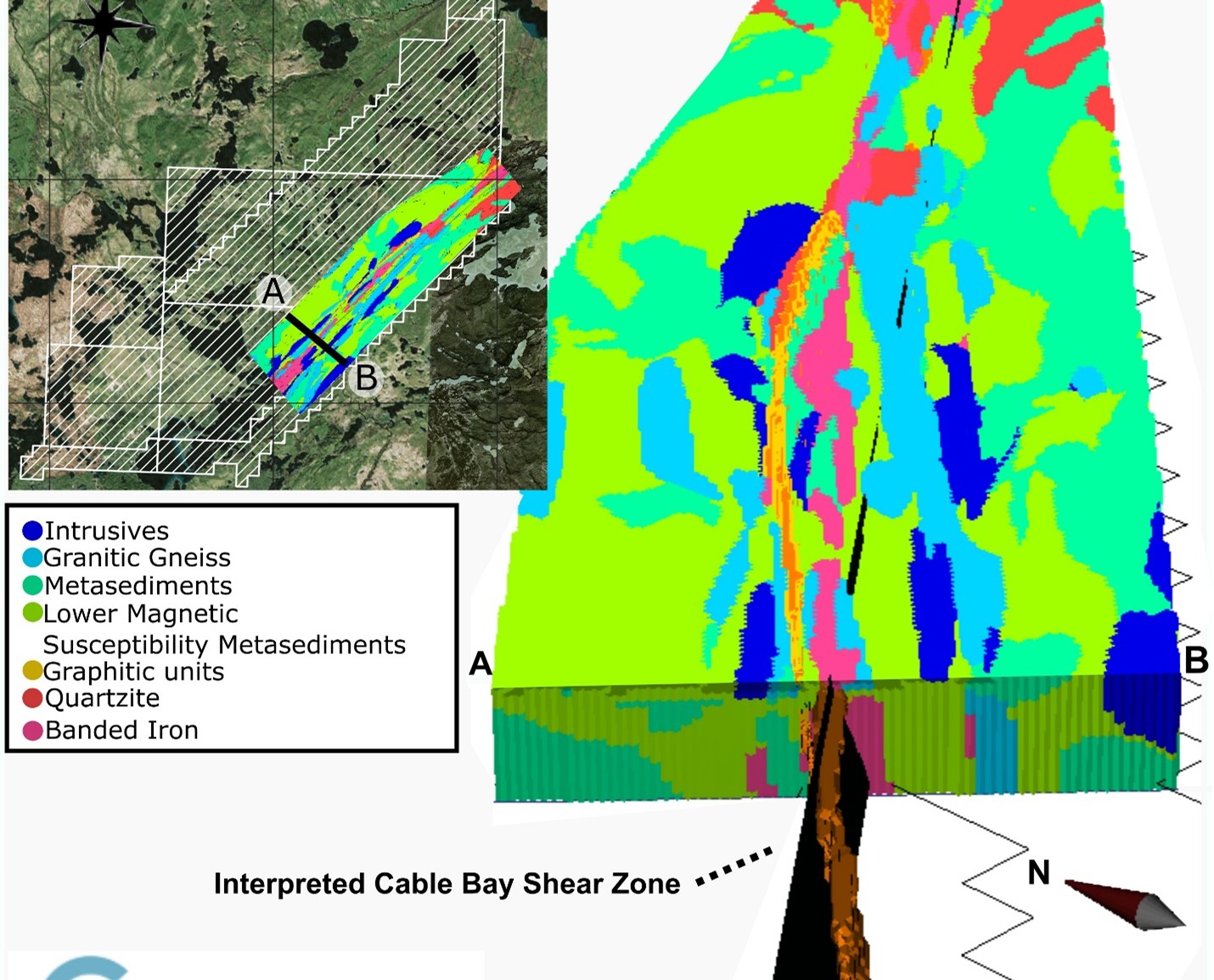
Figure 1. Isometric view of the GILI 3D lithology model, highlighting the CBSZ (black) and closely associated graphitic pelite horizons rendered as a solid surface (orange). The inset map provides a plan‑view perspective of the GILI model with Project claim boundaries overlain on high‑resolution aerial imagery.
Parametric VTEM™ Modelling Defines Steep Conductive Panels Along the CBSZ:
Initial unconstrained VTEM™ inversions were unable to fully resolve the steep, shear‑hosted conductors known from drilling and mapping. CGI applied parametric plate inversions, modelling the CBSZ as a series of steeply dipping rectangular conductive bodies.
This method provided a data‑driven estimate of:
- Strike and dip of graphitic pelite units;
- Conductivity contrasts along the shear zone; and
- Breaks, flexures, and offsets consistent with structural reactivation.
These plate geometries (Please see Figure 2) were then used as starting models or used in cross gradient inversions, improving the coherence and continuity of the Carpenter Lake conductive system.
Gravity Modelling Highlights Density Lows Coincident with Conductive Shear Zones:
Falcon AGG data were inverted using both unconstrained and structurally guided approaches. Cross‑gradient joint inversion was applied to align density contrasts with the VTEM™‑derived conductive structures. The Company plans to complete a higher-resolution ground gravity survey across the CBSZ, which will further refine the integrated modeling and future targeting.
The resulting gravity model reveals:
- Density‑low anomalies spatially coincident with conductive shear panels;
- Localized density disruptions adjacent to interpreted structural breaks; and
- Broader corridors of reduced density potentially related to hydrothermal alteration.
A secondary inversion was performed using a starting model derived from the GILI lithology output, further improving geological consistency.
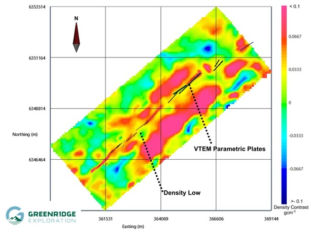
Figure 2. Elevation slice at 175 m from the gravity inversion model, generated using cross‑gradient constraints tied to the final VTEM™ parametric model. The conductive plate geometries from the VTEM™ inversion are shown, delineating the interpreted trace of the CBSZ.
GILI Lithology Interpolation Produces a New 3D Geological Framework:
CGI’s GILI platform integrated:
- TMI magnetic data;
- Surface geological mapping; and
- Drillhole lithology and magnetic susceptibility measurements collected in 2025.
GILI leverages proprietary AI and physics-based inversion modeling to create highly accurate 3D lithology models that automatically align geological data with magnetic surveys to pinpoint high-value targets with greater certainty.
The resulting 3D lithology model (Please see Figure 1) distinguishes:
- Graphitic pelite horizons forming the primary conductive targets;
- Low‑susceptibility intrusive and quartz-rich units;
- Moderate‑susceptibility granitic gneisses; and
- High‑susceptibility banded iron formations contributing to magnetic and gravity anomalies.
This model provides a consistent geological framework that ties together conductivity, density, and magnetic susceptibility.
Refined Targeting Along more than fifteen (15) km of the CBSZ:
The integrated inversion results have materially improved the understanding of structural architecture along the CBSZ. Several high‑priority target areas have been identified where the following ingredients all converge with a 3D shear corridor:
- Steeply dipping conductive plates;
- Coincident density‑low signatures;
- Structural breaks and offsets; and
- Favourable lithological architecture.
Many of these targets remain untested or only partially tested by historical drilling.
A Modern Reinterpretation Unlocking New Value from Existing Data
The Program demonstrates that advanced inversion workflows and machine‑learning‑assisted lithology modelling can extract significant geological insight from historical airborne and drilling datasets without requiring new geophysical acquisitions. Greenridge believes this modelling approach has significantly enhanced the discovery potential at Carpenter Lake and will directly inform the design and prioritization of the Company’s next phase of drilling along the CBSZ.
The Company and Convolutions led the geological integration and targeting strategy, while CGI executed the inversion workflow and delivered the 3D physical property and lithology models.
Statement of Qualified Person
The scientific and technical information contained in this news release has been reviewed and approved by Sean Hillacre, P. Geo., a geological consultant and Technical Advisor to the Company and a Qualified Person as defined in National Instrument 43-101 – Standards of Disclosurefor Mineral Projects (“NI 43-101”). Mr. Hillacre has examined information regarding the exploration at the Project and been involved in the geoscientific work outlined in this news release.
Specific geophysical information on the technologies and workflows in this news release have been reviewed and verified by Kyle Patterson, P. Geo., a third-party geophysical contactor to the Company and Qualified Person as defined in NI 43-101.
About Greenridge Exploration Inc.
Greenridge Exploration Inc. (CSE: GXP | OTCQB: GXPLF | FRA: HW3) is a mineral exploration company dedicated to creating shareholder value through the acquisition, exploration, and development of critical mineral projects in Canada. The Company owns or has interests in 23 projects and additional claims covering approximately 272,849 hectares with considerable exposure to potential uranium, gold, nickel, and copper discoveries. The Company is led by an experienced management team and board of directors with significant expertise in capital raising and advancing mining projects.
Greenridge has one of the largest uranium property portfolios in Canada consisting of 14 projects and additional prospective claims covering approximately 196,338 hectares. The Company has opportunities to realize value in a further 9 strategic metals projects which include, gold, nickel, and copper exploration properties totalling approximately 76,511 hectares. Property highlights include:
- The Black Lake Uranium Project, located in the NE Athabasca Basin, (40% Greenridge, 50.43% Uranium Energy Corp., 8.57% Orano Canada) saw a 2004 discovery hole (BL-18) return 0.69% U3O8 over 4.4m.1
- The Hook-Carter Uranium Project (20% Greenridge, 80% Denison Mines Corp.) is strategically located in the southwest Margin of the Athabasca Basin, sitting ~13km from NexGen Energy Ltd.’s Arrow deposit and ~20 km from Paladin Energy’s Triple R deposit.
- The Gibbons Creek Uranium Project hosts high-grade uraniferous boulders located in 2013, with grades of up to 4.28% U3O8 2, and the McKenzie Lake project saw a 2023 prospecting program return three samples which included 844 ppm U-total (0.101% U3O8), 273 ppm U-total, and 259 ppm U-total.3
- The Nut Lake Uranium Project located in the Thelon Basin includes historical drilling which intersected up to 9 ft of 0.69% U3O8 including 4.90% U3O8 over 1ft from 8 ft depth.4 In 2024, Greenridge’s prospecting program located a float sample that returned 31.13% U3O8, sourced from the Tundra Showing.5
- The Firebird Nickel Project has seen two drill programs (7 holes totaling 1,339 m), where hole FN20-002 intersected 23.8 m of 0.36% Ni and 0.09% Cu, including 10.6 m of 0.55% Ni and 0.14% Cu.6
The Company has strategic partnerships which includes properties being operated and advanced by Denison Mines Corp. and Uranium Energy Corp. The Company’s management team, board of directors, and technical team brings significant expertise in capital raising and advancing mining projects and is poised to attract new investors and raise future capital.
References:
1 – Black Lake: UEX Corporation News Release dated October 12, 2004.
2 – Gibbons Creek: Lakeland Resources Inc. News Release dated January 8, 2014.
3 – McKenzie Lake: ALX Resources Corp. New Release dated November 7, 2023.
4 – Nut Lake: 1979 Assessment Report (number 81075) by Pan Ocean Oil Ltd.
5 – Nut Lake: Greenridge Exploration Inc. News Release dated February 19, 2024.
6 – Firebird Nickel: ALX Resources Corp. New Release dated April 15, 2020.
On Behalf of the Board of Directors of Greenridge
Russell Starr
Chief Executive Officer, Director
Telephone: +1 (778) 897-3388
Email: info@greenridge-exploration.com
Disclaimer for Forward-Looking Information
This news release includes certain “Forward-Looking Statements” within the meaning of the United States Private Securities Litigation Reform Act of 1995 and “forward-looking information” under applicable Canadian securities laws. When used in this news release, the words “anticipate”, “believe”, “estimate”, expect”, “target”, “plan”, “forecast”, “may”, “would”, “could”, “schedule” and similar words or expressions, identify forward-looking statements or information.
Forward-looking statements and forward-looking information relating to any future mineral production, liquidity, enhanced value and capital markets profile of Greenridge, future growth potential for Greenridge and its business, and future exploration plans are based on management’s reasonable assumptions, estimates, expectations, analyses and opinions, which are based on management’s experience and perception of trends, current conditions and expected developments, and other factors that management believes are relevant and reasonable in the circumstances, but which may prove to be incorrect. Assumptions have been made regarding, among other things, the price of uranium, nickel, copper, gold, cobalt and other metals; costs of exploration and development; the estimated costs of development of exploration projects; Greenridge's ability to operate in a safe and effective manner and its ability to obtain financing on reasonable terms.
This news release contains “forward-looking information” within the meaning of the Canadian securities laws. Statements, other than statements of historical fact, may constitute forward looking information and include, without limitation, statements with respect to the Project and its mineralization potential; the Company’s objectives, goals, or future plans with respect to the Project; further exploration work on the Project in the future; and the potential benefits of conducting the Program. With respect to the forward-looking information contained in this news release, the Company has made numerous assumptions regarding, among other things, the geological, metallurgical, engineering, financial and economic advice that the Company has received is reliable and are based upon practices and methodologies which are consistent with industry standards. While the Company considers these assumptions to be reasonable, these assumptions are inherently subject to significant uncertainties and contingencies. Additionally, there are known and unknown risk factors which could cause the Company’s actual results, performance or achievements to be materially different from any future results, performance or achievements expressed or implied by the forward-looking information contained herein. Known risk factors include, among others: fluctuations in commodity prices and currency exchange rates; uncertainties relating to interpretation of well results and the geology, continuity and grade of uranium, nickel, copper, gold, cobalt and other metal deposits; uncertainty of estimates of capital and operating costs, recovery rates, production estimates and estimated economic return; the need for cooperation of government agencies in the exploration and development of properties and the issuance of required permits; the need to obtain additional financing to develop properties and uncertainty as to the availability and terms of future financing; the possibility of delay in exploration or development programs or in construction projects and uncertainty of meeting anticipated program milestones; uncertainty as to timely availability of permits and other governmental approvals; increased costs and restrictions on operations due to compliance with environmental and other requirements; increased costs affecting the metals industry and increased competition in the metals industry for properties, qualified personnel, and management. All forward-looking information herein is qualified in its entirety by this cautionary statement, and the Company disclaims any obligation to revise or update any such forward-looking information or to publicly announce the result of any revisions to any of the forward-looking information contained herein to reflect future results, events or developments, except as required by law.
The Canadian Securities Exchange (CSE) does not accept responsibility for the adequacy or accuracy of this release.
Photos accompanying this announcement are available at
https://www.globenewswire.com/NewsRoom/AttachmentNg/27c4a948-1f33-4389-a96f-af87c36e020d
https://www.globenewswire.com/NewsRoom/AttachmentNg/026b2bbb-fd5b-4949-b9cc-0c57d201a9d2


Figure 1.
Isometric view of the GILI 3D lithology model, highlighting the CBSZ (black) and closely associated graphitic pelite horizons rendered as a solid surface (orange). The inset map provides a plan‑view perspective of the GILI model with Project claim boundaries overlain on high‑resolution aerial imagery.
Figure 2.
Elevation slice at 175m from the gravity inversion model, generated using cross‑gradient constraints tied to the final VTEM™ parametric model. The conductive plate geometries from the VTEM™ inversion are shown, delineating the interpreted trace of the CBSZ.
© 2026 Canjex Publishing Ltd. All rights reserved.