Toronto, Ontario--(Newsfile Corp. - July 29, 2026) - Conquest Resources Limited (TSXV: CQR) ("Conquest" or the "Company") is pleased to announce results from its 2026 glacial till geochemical sampling program and prospecting rock sampling program at the Valimaki Gold Project in southwestern Finland. The 2026 till results outline multiple gold-in-till anomalies across the project area and provide a strengthened exploration framework for future drill targeting.
The 2026 till and prospecting programs form part of Conquest's broader spring 2026 exploration program at Valimaki, which included high-resolution UAV magnetics, geological mapping, legacy drill core review, prospecting and rock sampling. The program was designed to improve the Company's understanding of property-scale structures, lithological contacts, alteration and potential controls on gold mineralization, and to prioritize areas where gold-in-till anomalism coincides with favourable geological, geophysical, geochemical and historical exploration datasets.
Highlights
- Till sample results define multiple gold-in-till anomalies across the Valimaki project area, including the Kultakallio-Valimaki target area and the Silmusuo-Saarijarvi target corridor (Figure 1).
- The 2026 results include individual till sample values up to 499.9 ppb Au, with multiple additional samples above 100 ppb Au.
- The strongest clusters are spatially associated with areas of historic drilling, historic gold-bearing boulder occurrences and prospective magnetic and structural settings, including interpreted fold-related targets, shear corridors and magnetic breaks from the 2026 UAV magnetic survey and geological mapping.
- The 2026 till grid comprised 795 field samples plus 58 QA/QC samples, for a total of 853 samples across regional and priority target areas.
- The Company is integrating the till results with UAV magnetic products, geological mapping, prospecting, rock sampling, historical boulder data, previous drilling and legacy geochemical datasets to refine drill targets.
- Geological mapping and legacy core review completed in April 2026 support a structurally controlled orogenic gold model, with gold associated with quartz-garnet-feldspar-biotite veins, arsenopyrite-pyrrhotite sulphides and deformation zones in biotite and hornblende-biotite gneisses.
- Prospecting returned anomalous gold values from selected grab samples, including rock results up to 2.82 g/t Au, and provide supporting evidence for gold-bearing quartz-sulphide mineralization in areas coincident with the broader 2026 gold-in-till anomalies.
Valimaki Gold Project - Till Geochemistry Results
The 2026 glacial till sampling program comprised 795 field samples plus 58 QA/QC samples, for a total of 853 samples across regional and priority target areas. The program included regional coverage and tighter-spaced sampling across priority areas associated with historic gold-bearing boulder occurrences, previous drilling and existing till anomalies.
Kultakallio-Valimaki Target Area
In the Kultakallio-Valimaki target area, anomalous till samples define a broad cluster coincident with historic drilling and known gold-bearing boulder occurrences in the Kultakallio-Valimaki area. The results include multiple samples greater than 100 ppb Au, with selected anomalous results including 499.9 ppb Au, 214.1 ppb Au, 178.4 ppb Au, 105.3 ppb Au and 101.9 ppb Au. This area will be evaluated together with prospecting results, historical boulder data, geological mapping, interpreted glacial dispersion direction and mapped sheared biotite gneiss with quartz-feldspar veinlets to refine potential source target areas.
Silmusuo-Saarijarvi Target Corridor
In the Silmusuo-Saarijarvi target corridor, elevated gold-in-till values form a corridor of anomalous samples in proximity to historic drill collars and interpreted structural and magnetic features. The corridor overlaps the broader Silmusuo-Saarijarvi area, where historical GTK till and boulder data, together with historic drilling, provide additional support for follow-up targeting. Anomalous results include values of 483.1 ppb Au, 145.4 ppb Au and 125.1 ppb Au. The distribution of elevated gold-in-till values defines a priority corridor that will be evaluated for drill targeting through integration with geological, geochemical and geophysical datasets.
Regional Anomalies and Interpretation
Additional isolated and semi-continuous anomalous samples occur across the broader project area. These anomalies will be assessed against glacial dispersion direction, historical boulder occurrences, historical drilling, structural interpretation and the UAV magnetic dataset to determine whether they represent isolated one-off responses or credible follow-up targets. Priority will be given to areas where coherent elevated gold-in-till values coincide with favourable geological, structural and geophysical features.
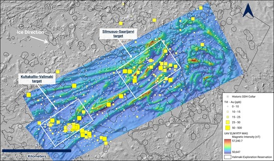
Figure 1. Valimaki 2026 gold-in-till geochemistry over the UAV ELM reduced-to-pole (RTP) magnetic intensity grid (nT).
To view an enhanced version of this graphic, please visit:
https://images.newsfilecorp.com/files/7183/306970_623b5c6a24188a77_001full.jpg
Prospecting and Rock Sampling Results
Prospecting and rock sampling were completed as part of the 2026 field program to evaluate historical gold-bearing boulder areas, test new mineralized float and outcrop occurrences, and provide lithological and mineralization context for the gold-in-till geochemical anomalies. The program comprised 119 prospecting rock samples, excluding QA/QC samples. Rock grab sampling returned anomalous gold values from selected float, subcrop and outcrop samples, including two samples above 1 g/t Au and results up to 2.82 g/t Au. Elevated gold values were returned from strongly silicified and sulphide-bearing mica gneiss, as well as from sulphide-bearing, sheared chloritized mafic/gabbroic rock.
Although drill targeting will be primarily driven by the intensity and continuity of the 2026 gold-in-till anomalies, the rock sampling results provide important supporting evidence for gold-bearing bedrock or near-source float in several parts of the project. The results will be integrated with the till geochemistry, historical boulder data, UAV magnetic interpretation, structural mapping and legacy drilling to refine target areas for follow-up and future drill testing.
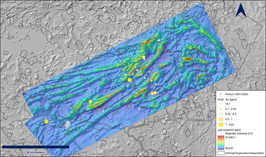
Figure 2. Valimaki 2026 rock sample gold geochemistry over the UAV ELM reduced-to-pole (RTP) magnetic intensity grid (nT).
To view an enhanced version of this graphic, please visit:
https://images.newsfilecorp.com/files/7183/306970_623b5c6a24188a77_002full.jpg
2026 Exploration Program and Next Steps
The 2026 exploration program was designed to systematically advance Valimaki through high-resolution geophysics, geological mapping, prospecting and glacial till sampling. The UAV magnetic survey covered approximately 86 km² across two planned blocks. The first block covered approximately 78 km² at 100 meter line spacing, with approximately 956 line-km flown including tie lines. A second block covering the southwest portion of the survey area was flown in May 2026.
The Company is integrating the 2026 till geochemistry with UAV magnetic data products, structural interpretation, mapping, prospecting, rock sampling, historical boulder data, previous drilling and legacy geochemical datasets. The intensity and continuity of the gold-in-till anomalies are expected to be the primary driver of target prioritization, with rock results, historic boulder data, geological observations and magnetic interpretation used to refine potential source areas and drill target geometry. Follow-up work is expected to focus on areas where gold-in-till anomalies overlap favourable structural, lithological and geophysical settings.
Sampling Protocols and QA/QC
Till Samples
All 2026 Valimaki till samples were collected under the supervision of project geologists. Samples were collected using a Dutch auger to obtain approximately 1 kg of B-horizon till material. BC- and C-horizon material was collected where possible. Samples were bagged and labelled in the field, returned to the crew facilities, and organized into secured shipment bags. Certified reference material and field duplicate samples were inserted into the sample stream at regular intervals, and sample batches were submitted to Bureau Veritas Minerals with corresponding sample submission forms.
Company-inserted QA/QC for the till program comprised OREAS 48 certified reference material inserted at sample numbers ending in 33, 66 and 99, equivalent to three standards per 100 samples. Field duplicate samples were collected and inserted at a frequency of four duplicates per 100 samples.
Sample preparation and analytical work for the till samples were carried out by Bureau Veritas Minerals. Sample preparation was completed at Bureau Veritas' Krakow, Poland facility, and analytical work was completed at its Vancouver, Canada laboratory. Samples were prepared using Bureau Veritas method SS230: individual samples were dried at 60°C, and up to 100 g was sieved to -230 mesh (-63 µm) for analysis. Samples were analyzed using Bureau Veritas method AQ252_EXT, with a 30 g split analyzed by aqua regia digestion and ultratrace ICP-MS finish for gold and multi-element geochemistry. Laboratory QA/QC results and Company-inserted standards and duplicate samples were reviewed, and no material QA/QC issues were identified.
Rock Samples
The 2026 prospecting rock sampling program comprised 119 prospecting rock samples and 9 Company-inserted QA/QC samples, for a total of 128 submitted samples. Rock samples were collected by or under the direct supervision of the project manager as selective grab samples from outcrop, subcrop, boulder and float material. Samples were bagged and labelled in the field and transported to the crew facilities, where QA/QC material was inserted at regular intervals. Sample batches were secured and submitted to Bureau Veritas Minerals with corresponding sample submission forms.
Company-inserted QA/QC for the rock program comprised 6 OREAS 241b certified reference material samples and 3 blanks. Blank material consisted of commercially sourced plagioclase-rich crushed rock. Rock duplicate samples were not inserted.
Sample preparation and analytical work for the 2026 rock sampling program were completed by Bureau Veritas Minerals. Samples were prepared using Bureau Veritas method PRP70-250, with individual samples crushed to 2 mm and a 250 g split pulverized to 75 µm for analysis. Gold was analyzed using Bureau Veritas method FA430, with a 30 g split analyzed by lead-collection fire assay with AAS finish. Multi-element geochemistry was analyzed using Bureau Veritas method MA200, with a 0.25 g split analyzed by multi-acid digestion with ICP-MS finish. Laboratory QA/QC results and Company-inserted standards and blanks were reviewed, and no material QA/QC issues were identified.
Selected grab samples are by nature selective and are not necessarily representative of mineralization on the project.
Qualified Person
The technical content of this news release has been reviewed and approved by Joerg Kleinboeck, P.Geo., a non-Independent Qualified Person as defined under National Instrument 43-101 – Standards of Disclosure for Mineral Projects. Joerg Kleinboeck, P. Geo., has verified the technical data disclosed in this release and consents to its publication.
About the Project
The Valimaki Gold Project is located east of Pori, a regional industrial city in southwestern Finland. The Project area benefits from excellent infrastructure and year-round access
The Project is located within the Pomarkku block of the Svecofennian geological domain, between two major northwest-southeast-trending regional structures: the Kynsikangas Shear Zone to the southwest and the Kankaanpää Shear Zone to the northeast. Gold mineralization in the Valimaki area is interpreted as orogenic-style mineralization hosted in amphibolite-grade supracrustal gneisses and related intrusive rocks. Mineralization is associated with quartz veining, arsenopyrite, pyrrhotite, pyrite and local chalcopyrite, with gold also associated with an Sb-Te-Bi-W-Ag geochemical signature, consistent with an orogenic gold system.
Historical exploration in the broader Kullaa-Valimaki area was carried out by Outokumpu Oy and Geologian Tutkimuskeskus ("GTK") from the 1950s through the 2010s. Historical work included till geochemistry, heavy mineral concentrate sampling, prospecting, geophysics and diamond drilling.
Historical GTK data and recent field review identify several prospective areas within the broader project area, including Kultakallio-Valimaki and Silmusuo-Saarijarvi. These areas are associated with historical gold-bearing boulders, anomalous till geochemistry, historic drilling, quartz-sulphide veining and structurally complex settings interpreted from mapping and magnetic data.
About Conquest Resources Limited
Conquest Resources Limited, incorporated in 1945, is a mineral exploration company exploring for base metals and gold on mineral properties in Ontario and Finland. Conquest recently acquired the Valimaki Gold Project in southwestern Finland, a district-scale gold exploration property with extensive historical exploration and drilling.
Conquest holds a 100% interest in the Belfast-Teck Mag Project, located in the Temagami Mining Camp at Emerald Lake, Ontario, which is believed to have exploration potential for magmatic sulphide deposits (Cu-Ni-PGE), VMS, IOCG, iron formation-hosted gold and paleo-placer gold. The Company also holds interests in the Alexander Gold Property, the Smith Lake Gold Property, the King Bay Gold Property and the Lake Nipigon Basin Property.
Cautionary Statement Regarding Forward-Looking Information
Certain statements included in this press release constitute forward-looking information or statements within the meaning of applicable Canadian securities legislation, including statements regarding the Company's exploration plans, interpretation of exploration results, potential mineralization, timing and scope of future work programs, permitting, drilling, and the validation and interpretation of analytical results.
Forward-looking statements are not historical facts but reflect current expectations regarding future results or events. Forward-looking information can often be identified by words such as "anticipate", "believe", "plan", "estimate", "expect", "intend", "may", "should", "will" and similar expressions. These statements are based on current expectations and assumptions that involve known and unknown risks, uncertainties and other factors that may cause actual results to differ materially from those anticipated.
Such risks include, but are not limited to, exploration results not being indicative of future results; variations in mineral grade, continuity or recovery; delays in interpreting analytical results; delays or failures in obtaining necessary permits or land access; changes in commodity prices, capital market conditions and general economic conditions; and other risks described in the Company's public filings available under its SEDAR+ profile.
Forward-looking statements contained herein are made only as of the date of this press release. The Company undertakes no obligation to update or revise any forward-looking statements except as required by applicable law. Readers are cautioned not to place undue reliance on forward-looking information.
Neither TSX Venture Exchange nor its Regulation Services Provider, as that term is defined in the policies of the TSX Venture Exchange, accepts responsibility for the adequacy or accuracy of this news release.

To view the source version of this press release, please visit https://www.newsfilecorp.com/release/306970

© 2026 Canjex Publishing Ltd. All rights reserved.