Vancouver, British Columbia--(Newsfile Corp. - April 8, 2026) - Bayridge Resources Corp. (CSE: BYRG) (OTCQB: BYRRF) (FSE: O0K0) ("Bayridge" or the "Company") is pleased to provide an update on completed data reinterpretation and planned 2026 exploration activities at its 51%-owned Baker Lake Uranium Project (the "Project"), located approximately 65 kilometres southeast of Baker Lake in the Kivalliq Region of Nunavut. The Company has completed a reinterpretation of historic airborne geophysical datasets, resulting in improved target definition and enhanced understanding of structural controls on uranium mineralization across the project. The updated interpretation provides a refined framework for prioritizing targets ahead of the proposed 2026 exploration program.
Highlights
Reinterpretation of historic airborne geophysical data has refined and prioritized uranium targets across the Baker Basin.
The original 2008 survey outlined 30 uranium-enhanced targets, now further constrained through integrated analysis.
Integrated magnetic, radiometric, and EM review has improved interpretation of structural controls and mineralization trends across the property.
Known mineralized occurrences show a consistent relationship with magnetic anomalies and uranium-associated radiometric responses, supporting the broader targeting model.
Planned 2026 work is designed to advance priority targets through surface exploration both mapping and prospecting, and up to 3,500 metres of diamond drilling, subject to permitting and results.
Data Reinterpretation and Target Advancement
The reinterpretation of historic geophysical data has materially improved the Company's understanding of the geological and structural framework controlling uranium mineralization at Baker Lake.
Planned 2026 field exploration at Baker Lake will focus on refining drill targets through the integration of geophysical and geochemical datasets. The program is expected to include surface exploration, completion of required environmental and archaeological assessments, and refurbishment of a previously disturbed historic exploration outpost to support operations. Bayridge has secured a drilling contractor and is actively advancing planning for the proposed 2026 program.
"Our review of the historic dataset has significantly enhanced our understanding of the structural and geophysical controls on uranium mineralization at Baker Basin," said Mark Richardson, Vice President of Exploration. "The integration of historical drill-confirmed mineralization at Lucky 7 and KZ, together with additional target definition at Atlas and Andromeda, provides a much stronger foundation for prioritizing follow-up work and future drill testing."
The updated model highlights the spatial association between uranium mineralization, magnetic anomalies, and radiometric responses, reinforcing the exploration targeting approach across multiple areas of the property.
"The results of our recent data reinterpretation have materially enhanced our understanding of the Baker Lake uranium system and elevated the quality of our target pipeline," said Saf Dhillon, President & CEO of Bayridge Resources. "We are now moving forward with a more refined and data-driven exploration strategy, supported by multiple high-priority targets across a district-scale land package. We look forward to advancing these targets through our 2026 program and positioning the Project for drill testing."
2026 Exploration Program
The planned 2026 field program will focus on advancing priority targets through the integration of geophysical reinterpretation and field-based validation.
Key components of the program are expected to include:
- Surface mapping and prospecting across priority target areas
- Completion of environmental and archaeological baseline studies
- Refurbishment of a historic exploration outpost to support field operations
- Follow-up evaluation of targets identified through geophysical reinterpretation.
Subject to permitting and initial results, the Company plans to undertake up to 3,500 metres of helicopter-supported diamond drilling to test priority uranium targets.
Bayridge has secured a drilling contractor and is actively advancing planning for the upcoming program.
Target Pipeline
Delta
Delta is Bayridge's most advanced target area and includes the Lucky 7, KZ Zone, and KZ Zone SE trends, where historical 2006–2007 drilling by Pacific Ridge confirmed a structurally controlled uranium system (Figure 1).
Historical drilling at Lucky 7 returned 17.3 m at 0.30% U3O8 in L7-07-08 and 10.0 m at 0.35% U3O8 in L7-07-10 (Figure 2), with mineralization traced to depths of more than 500 metres.
Historical drilling at KZ Zone returned 11.5 m at 0.31% U3O8 (Figure 3), including 5.5 m at 0.56% U3O8, in KZ-06-02 and 5.2 m at 0.40% U3O8, including 2.0 m at 0.90% U3O8, in KZ-06-04.
These historical results confirm bedrock uranium mineralization and support Delta as a priority drill target for 2026.
Mineralization has been traced to depths exceeding 500 metres.
These findings suggest the presence of a significant uranium-bearing system and support Delta as a priority drill target for the 2026 program.
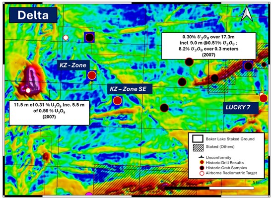
Figure 1. Horizontal derivative map of the Baker Lake Uranium Project highlighting the Delta target area. The map shows the KZ Zone, KZ Zone SE, and Lucky 7 in relation to historical drill results, surface uranium occurrences, airborne radiometric targets, and the interpreted unconformity.
To view an enhanced version of this graphic, please visit:
https://images.newsfilecorp.com/files/10256/291533_13dc82ef24fd4929_001full.jpg
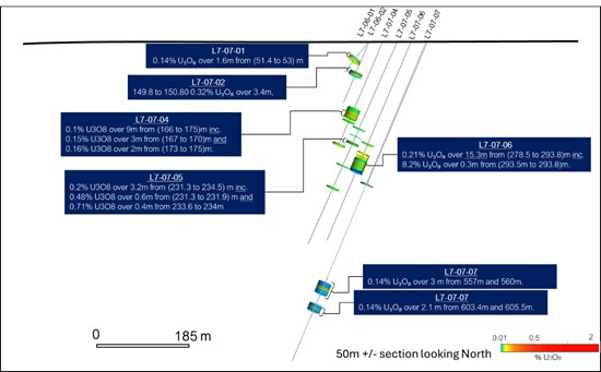
Figure 2: Lucky 7 Zone longitudinal section showing historical drill results from 2007 by Pacific Ridge. Drilling returned multiple uranium intersections over a significant vertical extent, including locally high-grade intervals, confirming Lucky 7 as one of the Project's key historical mineralized zones.
To view an enhanced version of this graphic, please visit:
https://images.newsfilecorp.com/files/10256/291533_13dc82ef24fd4929_002full.jpg
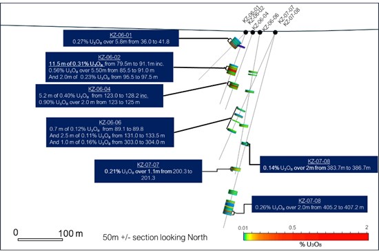
Figure 3: KZ Zone longitudinal section showing historical drill results from 2006 and 2007 by Pacific Ridge. Drilling intersected multiple zones of uranium mineralization over a broad vertical extent, including higher-grade intervals that highlight the scale and continuity of the system.
To view an enhanced version of this graphic, please visit:
https://images.newsfilecorp.com/files/10256/291533_13dc82ef24fd4929_003full.jpg
Atlas
Atlas is a multi-kilometre target corridor defined by airborne geophysics and regional geological mapping, with coincident radiometric and conductive features supporting its uranium potential (Figure 4).
Within Atlas, Iris has been identified as a 2026 priority for mapping and prospecting at the junction of a conductive anomaly and the interpreted unconformity.
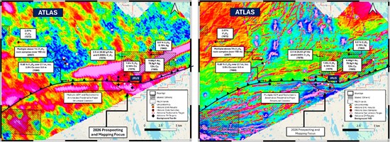
Figure 4: Baker Lake Uranium Project. Tau conductivity (left) and first vertical derivative ("1VD") magnetics (right) over the same area, highlighting historical drill results and surface uranium occurrences. The Iris target is located at the junction of a conductive anomaly and the interpreted unconformity.
To view an enhanced version of this graphic, please visit:
https://images.newsfilecorp.com/files/10256/291533_figure4.jpg
Andromeda Target
The Andromeda target is a large, underexplored radiometric anomaly with supporting geophysical signatures.
- Represents a district-scale exploration opportunity
- Prioritized for systematic surface work and target refinement in 2026.
The Baker Lake Uranium Project comprises 83 contiguous claims covering 619 km² in Nunavut's Kivalliq Region.
Exploration has defined a 75-kilometre unconformity corridor hosting multiple uranium targets supported by historical drilling and airborne geophysical surveys.
The recent reinterpretation of geophysical data strengthens the Company's target framework and supports a systematic approach to advancing the project toward drill testing.
Mark Richardson, P.Geo., Vice President of Exploration (NAPEG #2451), is the Qualified Person under NI 43-101 and has approved the technical content of this release.
About Bayridge Resources Corp.
Bayridge Resources Corp. is a green energy exploration company advancing a portfolio of Canadian uranium projects.
The Company's 51%-owned Baker Lake Uranium Project comprises 83 contiguous claims covering approximately 619 km² in the Kivalliq Region of Nunavut. Exploration has defined a 75-kilometre unconformity corridor hosting multiple uranium targets, supported by historical drilling and modern airborne geophysical surveys.
Bayridge has also earned a 40% interest in the Waterbury East Project, located approximately 25 kilometres northeast of the Cigar Lake Mine in the northeastern Athabasca Basin. Geophysical surveys have identified a 7-kilometre conductivity corridor, where historical drilling from the mid-2000s intersected faulted and altered basement rocks with localized uranium enrichment. Significant portions of this corridor remain untested.
Forward-looking information
This release contains statements and information that, to the extent that they are not historical fact, may constitute "forward-looking information" within the meaning of applicable securities legislation based on current expectations, estimates, forecasts, projections, beliefs and assumptions made by management of the Company. Forward-looking information is generally identified by words such as "believe", "project", "aim", "expect", "anticipate", "estimate", "intend", "strategy", "future", "opportunity", "plan", "may", "should", "will", "would", and similar expressions. Although the Company believes that the expectations and assumptions on which such forward-looking information are reasonable, undue reliance should not be placed on the forward-looking information because the Company can give no assurance that it will prove to be correct. Since forward-looking information addresses future events and conditions, by its very nature it involves inherent risks and uncertainties. Many factors could cause actual future events to differ materially from the forward-looking information in this news release. The forward-looking information included in this news release is expressly qualified by this cautionary statement. The forward-looking information contained in this news release is made as of the date hereof and the Company undertakes no obligation to update publicly or revise any forward-looking information, whether as a result of new information, future events or otherwise, unless so required by applicable laws.
The CSE has not reviewed, approved, or disapproved the contents of this press release.
Appendix
Historic Sampling, QAQC and Analytical Procedures
Pacific Ridge 2006 QA/QC and Analytical Procedures:
In 2006, Pacific Ridge collected 209 surface samples and 200 drill core samples from the 694, KZ, and Lucky 7 zones. Samples were sealed, bagged, and shipped by air to Activation Laboratories (ActLabs), Ancaster, Ontario, an ISO-accredited facility. Surface samples weighed 3-5 kg; drill core was split into ~1 m intervals (~2.5 kg). QA/QC included blank Kazan arkose and quarter-core duplicates inserted at ~5% frequency. Core was scanned with an Exploranium GR-135 scintillometer prior to sampling. All samples were crushed and pulverized to -150 mesh and analyzed using Fusion XRF and Delayed Neutron Counting (DNC) for uranium, with select fire assay-AA analysis for gold. Thirteen pulp check samples (~7%) were sent to SRC for independent verification.
Source: Pacific Ridge Exploration Ltd., 2006 Exploration Report, Baker Basin Property.
Pacific Ridge 2007 QA/QC and Analytical Procedures:
During the 2006-2007 work programs, 29 surface samples and 526 drill core samples were collected from the Lucky 7, Lucky 7 East, Area 8, and KZ zones. Samples were sealed, packed in rice sacks, and shipped by air to ActLabs, an ISO-registered laboratory. Core was split using a manual splitter into 0.5-1.0 m intervals. QA/QC included quarter-core duplicates inserted every ~20 samples (~4%) and blank Kazan arkose inserted every 10-20 samples (~5%). Core was scanned with an Exploranium GR-135 scintillometer prior to sampling. Samples were crushed to -150 mesh and analyzed by Fusion XRF and DNC for uranium, with select fire assay-AA for gold and silver. Thirty pulp check samples (~6%) were analyzed at SRC, returning results within ~5% of ActLabs values. All intervals represent core lengths; true widths are unknown.
Source: Pacific Ridge Exploration Ltd., 2007 Exploration Report, Baker Basin Property.
| Drill Collar Table – 2006 Pacific Ridge Exploration Drilling Campaign |
| Zone | Hole ID | Northing (UTM) | Easting (UTM) | Length (m) | Azimuth (°) | Dip (°) |
| 694 | 694-06-01 | 7,065,052 | 363,139 | 123.44 | 90 | -45 |
| 694 | 694-06-02 | 7,065,052 | 363,138 | 136.86 | 90 | -75 |
| 694 | 694-06-03 | 7,065,138 | 363,119 | 68.58 | 90 | -45 |
| 694 | 694-06-04 | 7,065,138 | 363,118 | 121.31 | 90 | -70 |
| 694 | 694-06-05 | 7,065,175 | 363,057 | 93.06 | 90 | -55 |
| 694 Subtotal | — | — | — | 543.25 | — | — |
| KZ | KZ-06-01 | 7,079,071 | 372,753 | 148.57 | 282 | -45 |
| KZ | KZ-06-02 | 7,079,071 | 372,753 | 168.25 | 282 | -70 |
| KZ | KZ-06-03 | 7,079,071 | 372,754 | 55.17 | 180 | -45 |
| KZ | KZ-06-04 | 7,079,065 | 372,768 | 180.87 | 287 | -70 |
| KZ | KZ-06-05 | 7,079,118 | 372,767 | 179.22 | 287 | -75 |
| KZ | KZ-06-06 | 7,079,069 | 372,784 | 317.14 | 282 | -80 |
| KZ Subtotal | — | — | — | 1,049.22 | — | — |
| Lucky 7 | L7-06-01 | 7,078,202 | 382,264 | 85.59 | 235 | -50 |
| Lucky 7 | L7-06-02 | 7,078,202 | 382,264 | 139.6 | 235 | -66 |
| Lucky 7 | L7-06-03 | 7,078,202 | 382,264 | 158.19 | 235 | -80 |
| Lucky 7 Subtotal | — | — | — | 383.38 | — | — |
| Total Drilled (2006) | — | — | — | 1,969.50 m | — | — |
|
|
|
|
|
|
|
| Source: Pacific Ridge Exploration Ltd. (2006), Baker Basin Exploration Report. |
| Drill Collar Table – 2007 Pacific Ridge Exploration Drilling Campaign |
|
|
|
|
|
|
|
| Zone | Hole ID | Northing (UTM) | Easting (UTM) | Depth (m) | Azimuth (°) | Dip (°) |
| Lucky 7 | L7-07-04 | 7,078,213 | 382,290 | 237.1 | 237 | -66 |
| Lucky 7 | L7-07-05 | 7,078,227 | 382,317 | 459.6 | 245 | -66 |
| Lucky 7 | L7-07-06 | 7,078,243 | 382,342 | 450.2 | 236 | -66 |
| Lucky 7 | L7-07-07 | 7,078,253 | 382,374 | 736.4 | 236 | -66 |
| Lucky 7 | L7-07-08 | 7,078,172 | 382,316 | 282.5 | 236 | -60 |
| Lucky 7 | L7-07-09 | 7,078,128 | 382,339 | 276.5 | 236 | -60 |
| Lucky 7 | L7-07-10 | 7,078,128 | 382,339 | 378.6 | 236 | -71 |
| Lucky 7 Subtotal | — | — | — | 2,820.90 | — | — |
| KZ | KZ-07-07 | 7,079,055 | 372,817 | 306.9 | 282 | -66 |
| KZ | KZ-07-08 | 7,079,055 | 372,817 | 450.4 | 282 | -75 |
| KZ Subtotal | — | — | — | 757.3 | — | — |
| Total Drilled (2007) | — | — | — | 3,578.20 m |
|
|
References:
Pacific Ridge Exploration Ltd. (2007). 2006 exploration report on prospecting, radiometrics and drilling, Baker Basin property, Kivalliq Region, Nunavut (pp. 1-68). Pacific Ridge Exploration Ltd.
Pacific Ridge Exploration Ltd. (2008). 2007 Baker Basin exploration report: Drilling, prospecting, geological mapping, and radiometric surveying, Kivalliq Region, Nunavut (pp. 1-82). Pacific Ridge Exploration Ltd.

To view the source version of this press release, please visit https://www.newsfilecorp.com/release/291533

© 2026 Canjex Publishing Ltd. All rights reserved.