Vancouver, British Columbia--(Newsfile Corp. - October 6, 2026) - Astra Exploration Inc. (TSXV: ASTR) (OTCQX: ATEPF) (FSE: S3I) ("Astra" or the "Company") is pleased to provide results of the exploration activities at the Don Mario high-sulphidation epithermal (HSE) gold project in the Maricunga District of northern Chile.
Astra's CEO, Brian Miller, commented:
"Astra has a unique portfolio of exploration properties in Argentina and Chile and recently has taken the opportunity to advance Don Mario to the drill stage. The combination of outcropping gold mineralization with a large alteration zone and overlapping geophysical and geochemical targets makes for a compelling large-scale HSE target in the Maricunga Belt – a belt known to produce several world-class gold mines. We intend to proceed and drill the project in the coming months with a 2,000 – 3,000 metre fully-funded program and are pleased to add this discovery opportunity to our large flagship La Manchuria drilling program."
Astra's Exploration Director, Diego Guido, commented:
"The different exploration tools used at Don Mario have significantly improved our understanding of this large high sulphidation target, vectoring toward the prospective portions of the system. The distribution of the gold-silver surface anomalies into silicified diatreme breccias, together with the deeper resistive anomaly identified by the CS-NSAMT survey, suggests that the system may preserve both shallow disseminated mineralization and deeper feeder structures."
Don Mario Exploration Results
The Company has received the results of a low-cost exploration program completed at the Don Mario Project (See NR 2026-05-30 Astra Provides Exploration Update and Receives Independent Analyst Coverage from ATB Cormark Capital Markets), located within the eastern Maricunga gold belt of northern Chile. The program included geological mapping of the property, a combined geochemical and spectral mineralogy survey and three Controlled and Natural Source Audiofrequency Magnetotelluric (CS-NSAMT) survey lines.
The results outline a 2 kilometre by 1 kilometre gold and silver geochemical target concentrated in the southwestern portion of a larger 2 kilometre by 2 kilometre lithocap within the 4,480 hectare property. Don Mario is located within the Maricunga gold belt, which is one of the most prolific gold districts in the world containing several large HSE and porphyry deposits.
Eight shallow RC holes were completed by previous operators and returned 20 metres and 32 metres of 0.41 g/t gold and 0.38 g/t gold respectively, in two separate holes. These holes were completed to the east of the current focus of exploration, and did not test Astra's currently high-priority drill targets. Drill results by previous operators are historical in nature and have not been verified by Astra.
Geology of Don Mario project
Astra's geological mapping of the Don Mario project (Figure 1) shows a strong overlapping 2 kilometre by 1.8 kilometre area of intense hydrothermal alteration identified from satellite imagery and the Cerro Bayo Volcanic Complex. The Complex includes a dacitic to rhyodacitic dome forming the Cerro Bayo hill in the northeast portion of the alteration anomaly, surrounded by phreatomagmatic tuffs exposed mainly to the west (Figure 1).
The Cerro Bayo Volcanic Complex is interpreted to continue westward beneath shallow modern cover, based on several subcrops and small outcrops identified along creeks in this area. Portions of the target geology are pervasively silicified and locally form vuggy silica and hydrothermal breccias cemented by quartz-alunite and jarosite. Previous exploration by other operators at the Project identified locally elevated gold values within some of these hydrothermal breccias.
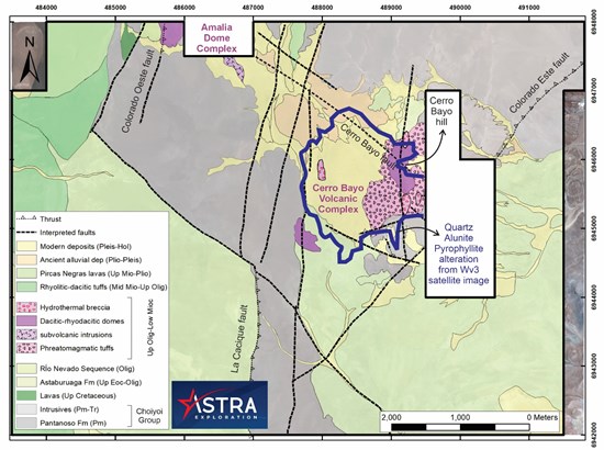
Figure 1: Don Mario project geological map produced by Astra's geologist based on previous maps 1-2-3, satellite interpretation and field observations. Note the correlation of the quartz-alunite-pyrophyllite hydrothermal alteration (dark blue thick polygon) with the phreatomagmatic tuffs and volcanic dome of the Cerro Bayo Volcanic Complex.
To view an enhanced version of this graphic, please visit:
https://images.newsfilecorp.com/files/8951/317591_67a0974a84c9a95e_002full.jpg
Alteration and Geochemistry of Don Mario
A total of 261 grid samples were collected and analyzed for alteration assemblages. The results show a strong correlation with the alteration patterns interpreted from satellite imagery and confirm the presence of a quartz-alunite-pyrophyllite alteration assemblage (Figure 2). Alteration assemblage interpretation defined 3 zones: the shallow lithocap with K-rich alunite (Zone 1), the deeper lithocap with Na-rich alunite (Zone 2) and the higher temperature feeder zones with pyrophyllite (Zone 3).
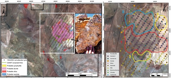
Figure 2: Don Mario property map with sampling grid shown, and detail to the right (white rectangle) of the results obtained with detailed spectral mineralogy studies. Red outline is Zone 1, Blue outline is Zone 2 and Yellow outlines are Zone 3 alteration assemblages.
To view an enhanced version of this graphic, please visit:
https://images.newsfilecorp.com/files/8951/317591_67a0974a84c9a95e_003full.jpg
The same grid was sampled for lag geochemistry. The results define a 2 kilometre by 1 kilometre, NW-elongated gold-silver anomaly, concentrated predominantly west and southwest of the main lithocap (Figure 3). The strongest gold anomalies range up to 0.2 g/t gold and display a predominantly E-W orientation. Silver anomalies are more extensive and range up to 2.0 g/t silver.
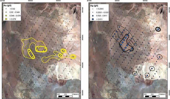
Figure 3: Gold and Silver results obtained from the sample grid at Don Mario HSE alteration area.
To view an enhanced version of this graphic, please visit:
https://images.newsfilecorp.com/files/8951/317591_astrafigurethree.jpg
In addition to the grid sampling, nine rock-chip samples were collected from surface outcrops within the survey area. These samples returned gold and silver anomalies, with maximum values of 1.35 g/t gold and 1.14 g/t silver. The highest gold value was obtained from a hydrothermal breccia located south of Cerro Bayo hill (photo in Figure 2).
Geophysics of Don Mario
To further evaluate the lithocap alteration and associated geochemical anomalies, Astra completed a three-line CS-NSAMT survey along NE-SW-oriented profiles crossing the NW-oriented target area (green lines, Figure 2).
The CS-NSAMT results identify a shallow high-resistivity anomaly approximately 200 to 400 metre thick, occurring between approximately 4,600 and 5,000 metres elevation and extending for at least 600 metres across the three sections. A second, deeper resistive anomaly extends to approximately 4,000 metres elevation, or approximately 1,000 metres below surface, and is concentrated toward the southwest on sections L2 and L3 (Figure 4).
These resistive anomalies are the exact targets for vuggy silica at the core of a high sulphidation system.
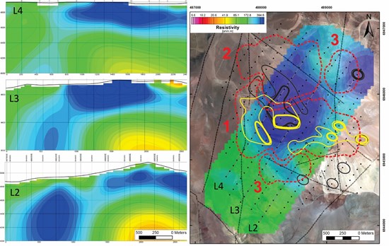
Figure 4: 3D inversion sections and plan map (4,800 metres) of the geophysical survey from Don Mario integrated with the geochemical anomalies for gold and silver and the three alteration Zones from alteration detail work.
To view an enhanced version of this graphic, please visit:
https://images.newsfilecorp.com/files/8951/317591_67a0974a84c9a95e_006full.jpg
Don Mario Targeting Summary
The combination of geological mapping, alteration mineralogy, geochemistry and geophysics supports the interpretation of a large HSE system with multiple exploration targets. These include:
- A shallow, disseminated gold and silver mineralization target associated with a large (1 by 1 kilometre) flat lying lithocap with favorable alteration (Zone 1).
- Deeper HSE-porphyry transition target located NW of the area (Zone 2).
- Potentially higher-grade feeder-zone targets (Zones 3), associated with faults and deep resistivity anomalies (L2 line in Figure 4) to the south of the area.
The results provide compelling targets for follow-up exploration, including drill testing of the most prospective portions of the Don Mario HSE system. Astra intends to undertake a drill program of approximately 2,500 metres, currently planned to commence in Q1 2027.
Sampling procedure
At each sampling location, two samples were collected: one for LAG analysis and another for Terraspec analysis. A maximum offset of 10 metres from the theoretical sampling point was established, depending on field conditions.
At each sampling site, the surface soil layer was removed over an area of approximately 1 m², using a brush to eliminate coarse fragments. The material was collected with a plastic scoop, without exceeding a depth of 5 centimetres.
LAG sampling consisted of the collection of surface material with a particle size ranging from 2 milimetres to 4.75 milimetres, using a sieve system (No. 4 mesh over No. 10 mesh). The material was manually sieved in the field, collecting approximately 1 to 1.5 kilograms per sample. Samples were stored in 25 × 35 centimetre bags, properly labeled and identified.
Samples were sent to ALS Labs in Copiapó and analyzed with the following routine: PREP-31B, AuME-ST43.
Additionally, at each sampling location, a sample was collected for Terraspec analysis by manually selecting fragments from the material retained on the upper sieve (approximately 2 to 5 centimetres in size), with an approximate weight of 100 grams. These samples were stored in 10 × 10 centimetre properly labeled Ziploc bags and sent to a consultant company to analyze.
From the designed grid, only samples between localities 250 and 255 could not be surveyed due to operational difficulties associated with terrain conditions.
To ensure analytical quality control (QA/QC), a systematic protocol was implemented that included the insertion of 14 QAQC samples, including duplicate samples, standards, and blanks.
Qualified Person
The technical data and information as disclosed in this news release has been reviewed and approved by Darcy Marud, who is an Independent Director of Astra. Mr. Marud is a Practicing Member of the Association of Professional Geoscientists of Ontario and is a qualified person as defined under the terms of National Instrument 43-101 – Standards of Disclosure for Mineral Projects.
About the Company
Astra Exploration Inc. is a precious metals exploration company based out of Vancouver, BC that is actively building a portfolio of high-quality projects in some of the most important mining jurisdictions in Latin America.
The 80% owned La Manchuria gold-silver project in Santa Cruz, Argentina, over which Astra has an option to acquire 90% interest from Patagonia Gold Corp, is a high-grade gold and silver low sulphidation epithermal (LSE) deposit located in the prolific Deseado Massif which hosts multiple world-class LSE precious metals deposits including Cerro Vanguardia and Cerro Negro, Santa Cruz, Argentina.
The 100% owned Pampa Paciencia gold and silver project in northern Chile is located in the Paleocene mineral province in proximity to such major operating mines as Spence and Sierra Gorda. The project shares several important geological similarities to other Paleocene LSE gold-silver deposits including Faride and El Peñón.
The 100% owned Don Mario (renamed from Cerro Bayo) project in northern Chile is located in the Maricunga belt approximately 20 kilometres from the Refugio Mine. The project hosts a high sulphidation epithermal (HSE) +/- porphyry gold system with similarities to the Salares Norte deposit to the north in the same belt. The Maricunga belt is one of the most endowed regions in the world for gold and copper deposits.
References:
1 Clavero, J.; Pérez-Flores, P.; Ramírez, V., 2021. Reconocimiento geológico-estructural del sector Amalia-Cerro Bayo, región de Atacama. Goldfields Internal Report: 51 p.
2 Cornejo, P. 2010. Geología Distrital Prospectos Cacique y Cerro Bayo N, Franja Maricunga. Report (unpublished). Minera Yamana Chile SpA internal report: 16 p.
3 Mpodozis, C; Clavero, J; Quiroga, R; Droguett, B; Arcos, R. 2018. Geología del área Cerro Cadillal-Cerro Jotabeche, región de Atacama. Servicio Nacional de Geología y Minería, Carta Geológica de Chile, Serie Geología Básica 200: 157 p., 1 mapa escala 1:100.000. Santiago.
Neither the TSXV nor its Regulation Services Provider (as that term is defined in the policies of the TSXV) accepts responsibility for the adequacy or accuracy of this release.
This news release may contain certain "Forward-Looking Statements" within the meaning of the United States Private Securities Litigation Reform Act of 1995 and applicable Canadian securities laws. When or if used in this news release, the words "anticipate", "believe", "estimate", "expect", "target", "plan", "forecast", "may", "schedule" and similar words or expressions identify forward- looking statements or information. These forward-looking statements or information may relate to the Company's business activities; exploration on the Company's properties including drilling at the La Manchuria project. Such statements represent the Company's current views with respect to future events and are necessarily based upon a number of assumptions and estimates that, while considered reasonable by the Company, are inherently subject to significant business, economic, competitive, political and social risks, contingencies and uncertainties. Many factors, both known and unknown, could cause results, performance or achievements to be materially different from the results, performance or achievements that are or may be expressed or implied by such forward-looking statements. Such factors include, without limitation: development of the industry in which the Company operates; risks associated with the conduct of the Company's business activities; risks relating to reliance on the Company's management team and outside contractors; currency fluctuations; risks regarding the failure to generate sufficient cash flow from operations; laws and regulations governing the industry in which the Company operates; the ability of the communities in which the Company operates to manage and cope with the implications of COVID-19; the economic and financial implications of COVID-19 to the Company; operating or technical difficulties; employee relations, labour unrest or unavailability; stock market volatility; conflicts of interest among certain directors and officers; lack of liquidity for shareholders of the Company; litigation risk; and other risk factors disclosed in the Company's public disclosure documents available on the Company's profile at www.sedarplus.ca. Readers are cautioned against attributing undue certainty to forward-looking statements or forward-looking information. Although the Company has attempted to identify important factors that could cause actual results to differ materially, there may be other factors that cause results not to be anticipated, estimated or intended. The Company does not intend, and does not assume any obligation, to update these forward-looking statements or information to reflect changes in assumptions or changes in circumstances or any other events affecting such statements and information other than as required by applicable laws, rules and regulations.

To view the source version of this press release, please visit https://www.newsfilecorp.com/release/317591

© 2026 Canjex Publishing Ltd. All rights reserved.