(via TheNewswire)
CALGARY, ALBERTA - Sept 17, 2026 – TheNewswire - Ashley Gold Corp. (CSE: “ASHL”) (“Ashley ” or the “Company ”) is pleased to provide the markets with a comprehensive business update.
Positioning:
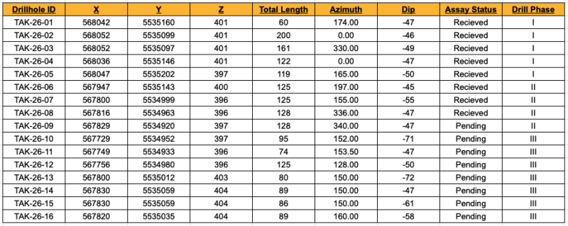
1 Phase II hole remains outstanding (TAK-26-09, 67Z undercut),
7 Phase III holes remain pending,
7 Phase IV holes planned, hole TAK-26-17 underway.
Click Image To View Full Size
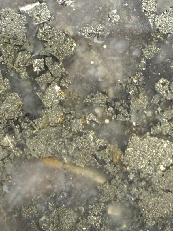
Figure 1: Possible High Grade Zone, East of the 67Z - TAK-26-16 - ~63.5m Downhole
President Noah Komavli: “Our crews are back on the ground - working towards our mission of unifying the 67Z and D99Z. Since acquiring the Tak Patents in early 2026, we have applied consistent effort, with each subsequent program being more impactful than the last. Phase IV drilling should be no exception, with true step outs east of the 67Z to test high priority IP features, ground truthed by recent prospecting.”
LiDAR Survey:
Aside from generating a digital terrain model that will upgrade how the Company plots and plans drilling, LiDAR surveys have a variety of outputs that will deepen our understanding of the terrain, including the ability to map:
1) Linear depressions or subtle scarps that mark faults, shear zones, and lineaments,
2) Changes in topographic fabric that correspond to lithological contacts or fold hinges,
3) Offsets or intersections of structures that can focus mineralizing fluids.
To keep mobilization costs low, the Company has commissioned LiDAR surveys across two projects - in combination with another regional peer; Cascade Copper Corp.
The program is designed to produce high-density canopy-penetrating LiDAR and 10 cm imagery using a helicopter-mounted Riegl VUX-240 scanner and PhaseOne iXM 100MP camera. Data are scheduled for acquisition beginning mid- to late September 2026. LiDAR products are targeted for delivery approximately six weeks after survey completion; optional orthophotos within six to eight weeks. Processing is performed in-house by Pioneer Exploration Consultants Ltd.
Core LiDAR deliverables:
Survey technical and quality-control report describing acquisition methods and results. Relative model accuracy is expected at approximately 15 cm without surveyed ground control; ASPRS positional accuracy and Canadian Quality Level 1 (CQGL1) products can be produced if sufficient ground control is supplied or collected.
Ground-classified, calibrated point cloud in ASPRS LAS 1.4 (LAZ) format at a raw density of approximately 40–50 points per square metre.
Tiled digital terrain model (DTM) and digital surface model (DSM) in GeoTIFF format.
All geospatial products will be delivered in NAD83 CSRS UTM Zone 15N, CGVD2013, metres.
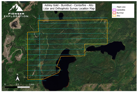
Figure 2: Proposed Flight Path over the Alto-Gardnar Project
Click Image To View Full Size
Table 1: Ashley TAK - Collar Data & Hole Status
Tak Project - Background
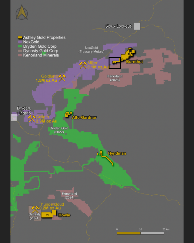
Situated abutting the Northeast of the Goliath Gold Complex, the Tak Patents have been the subject of intermittent exploration efforts from the 1900’s, with legendary companies like Lac Minerals (Barrick) and Cominco (Teck) exploring in and around the patented ground. At least two surveys were flown, with the most detailed mapping occurring in the late 1900’s. Within the patented boundary, only 11 historic holes were ever recorded from two operators - in 1999 and 2002. After 2002, the project sat idle for 24 years until acquired by the Company.
Click Image To View Full Size
Figure 3: Regional Map and Area of Activity
In 2026, mere weeks after acquisition, Ashley commissioned the first modern IP survey. The results highlighted a +1km resistive body, with two main chargeable units flanking the resistive body to the North. Ashley engaged 518 Drilling Ltd., deploying equipment into the patents for continued use. Guided in part from historic records and Phase 1 drilling results, three high priority zones have emerged.
Exploration Zones
D99Z:
In early 2026, a 5 hole, first phase program was successful in validating and expanding 1999 results. The zone was given the moniker “D99Z ”. With the final two holes still pending from Phase 1 drilling, the surface mineralization width in the D99Z is already estimated at +80m.
67Z:
Two holes carried out in 2002 included TAK-02-06 and TAK-02-07, intercepting 3.08 g/t Au over 7.57 m (incl. 7.0 g/t Au over 1.1 m) and 3.18 g/t Au over 8.7 m (incl. 9.67 g/t Au over 0.8 m), respectively (Southern Rio, 2002). These intercepts were some of the best in recorded history on the Tak Patents, and the area was given the title “67Z ” by Ashley. In Phase 2 drilling, Ashley deployed 3 holes on IP line 250 to target the zone and collect data on lithologies, as well as dip. TAK-26-08 was the first hole collared North, intercepting two zones of visible gold, assaying 0.729 g/t Au over 38.75m (incl. 0.961 g/t Au over 27.50m, incl. 1.43 g/t Au over 17.00m, incl. 9.200 g/t Au over 0.5 m).
NTZ:
The Northern Trench Zone (“NTZ” ) comprises five trenches, up to 2m wide, 2m deep and some as long as 60m. This area has no drilling records, yet was worked vigorously, as evidenced by the scale of the trench networks. Ashley discovered a high-grade gold zone through prospecting, sampling up to 398 g/t Au. The surface expression of the vein was traced for over 300m west of the high-grade grab sample.
Tak History
January 1940s - Long Lac Minerals (Mosher Long Lac Gold Mines Ltd.), extensive surface trenching (trenches up to 70 m long) on the Tak Grid targeting gold mineralization in quartz-feldspar porphyry (QFP); followed by 1948 magnetometer survey. MDI .
1980 - Cominco, geological mapping, rock sampling, and magnetometer survey over the property identifying porphyry-hosted gold potential. MDI .
1998-1999 - Triex Resources, acquired the Tak Patents; conducted prospecting, sampling, trenching (assays 1,100–29,790 ppb Au), and drilled 10 DDH (~1,558 m total), including TAK-99-10 returning 2.082 g/t Au over 31.83 m from 3.57–35.40 m (incl. 11.778 g/t Au over 2.88 m and 7.632 g/t Au over 1.10 m); outlined stockwork quartz-carbonate veining in silicified/carbonatized QFP ; MDI .
2002 - Southern Rio Resources, optioned the property from Triex and drilled 8 DDH (~1,209 m) on the Tak Grid; outlined gold mineralization over ~350 m strike length to ~100 m depth with stockwork veining, visible gold noted, and intercepts including TAK-02-06: 3.08 g/t Au over 7.57 m (plus 7.0 g/t Au over 1.1 m) and TAK-02-07: 3.18 g/t Au over 8.7 m (incl. 9.67 g/t Au over 0.8 m). Southern Rio AFRI report.
January 6, 2026 - Ashley Gold Corp., acquired 100% ownership of the Tak Patents (part of Burnthut Project, ~100 ha patented ground adjoining NexGold Goliath-Gold Complex) via all-stock deal from for 3.5M shares; consolidates historical data showing bulk-tonnage QFP-hosted gold potential open in all directions; 5% NSR to Royal Gold Inc. (2.5% buyback for $1M).
February 10, 2026 - Ashley Gold Corp., announced operational readiness for winter drilling campaign on Tak Patents and engagement of Abitibi Geophysics for first-ever modern OreVision IP survey to refine targets and twin historic holes.
March 14, 2026 - Ashley Gold Corp., provided interim IP data revealing 1 km resistive trend on Tak Patents aligning with historic gold zones and abutting NexGold Goliath-Gold Complex.
April 2–10, 2026 - Ashley Gold Corp., completed mobilization to site (drill trails, 10+ pads, rig and skidder in place) and announced crew mobilization/drilling kick-off for Phase 1 program targeting validation of historic D99Z zone and extensions .
April–May 2026 - Ashley Gold Corp., completed Phase 1 diamond drilling (5 holes: TAK-26-01 to TAK-26-05) as twins/fans to historic holes; core logging/cutting showed strong alteration, pyrite, and quartz-carbonate veining with multiple visible mineralization examples; equipment left on site for Phase 2.
May 14, 2026 - Ashley Gold Corp., reported first Phase 1 assay (TAK-26-01): 1.104 g/t Au over 28 m from collar (incl. 1.662 g/t Au over 12 m), confirming and validating historic near-surface mineralization in D99Z zone; mineralization starts at surface with strong continuity of grade within interval.
May 20, 2026 - Ashley Gold Corp., reported TAK-26-02 assays: multiple gold intervals including 0.586 g/t Au over 34.2 m from surface within 194.1 m of anomalous gold mineralization, further confirming broad width and continuity of the mineralized D99Z stockwork system south of TAK-26-01.
June 4, 2026 - Ashley Gold Corp., reported TAK-26-03 assays: multiple gold intervals including 2.347 g/t Au over 4.35 m within 156.5 m of anomalous gold mineralization, further confirming broad width and continuity of the mineralized D99Z stockwork system south of TAK-26-01.
NI 43-101 Disclosure
The technical information in this news release was reviewed and approved by Shannon Baird, P.Geo., a Qualified Person as defined in National Instrument 43-101. Mr. Baird is Exploration Manager of Ashley Gold Corp. and registered as a Professional Geoscientist with the Professional Geoscientists of Ontario as well as the Engineers and Geoscientists of British Columbia.
Some results discussed in this document are historical. Ashley Gold Corp. nor the qualified person have performed sufficient work or data verification of the historical data. Although the historical results may not be reliable, the Company nevertheless believes that they provide an indication of the Project's potential and are relevant for any future exploration program. True thickness is unknown.
The scientific and technical information below is disclosed solely with respect to nearby properties. Information disclosed from nearby properties is not necessarily indicative of the mineralization on the property that is the subject of this disclosure.
Map Citations
All scientific and technical information is sourced from the following prior public disclosures and technical reports:
Thundercloud Property (Pelham Zone) – Dynasty Gold Corp.
Mineral Resource (NI 43-101 2.2(d))
Inferred: 4,140,000 tonnes grading 1.37 g/t Au containing 182,000 ounces of gold (0.45 g/t Au cut-off).
Goliath Gold Complex (Goliath, Goldlund & Miller) – NexGold Mining Corp.
Mineral Resources (NI 43-101 2.2(d))
Measured + Indicated: 67,711,000 tonnes grading 0.98 g/t Au containing 2,138,600 ounces of gold.
Inferred: 32,571,000 tonnes grading 0.75 g/t Au containing 782,800 ounces of gold.
Mineral Reserves (NI 43-101 2.2(d))
Proven + Probable: 30,319,000 tonnes grading 1.30 g/t Au containing 1,267,000 ounces of gold.
ABOUT ASHLEY GOLD CORP.
Ashley Gold Corp. is a Canadian mineral exploration company focused on acquiring and developing highly prospective gold and polymetallic deposits in Canada’s top mining regions. The Company’s flagship assets are in the Dryden Area in Ontario with a 100% ownership in Santa-Maria, Burnthut (including the Tak Patents), Howie, and Alto-Gardnar claims as well as in British Columbia with the Icefield Portfolio having two highly prospective claim packages.
For more information, please refer to the Company’s information available on SEDAR+ (www.sedarplus.ca), or visit us at www.ashleygoldcorp.com .
Contact Information
On behalf of the Board of Directors,
“Noah Komavli”
Noah J. Komavli, P.Eng, President, Director
C: (647) 567-9840
E: info@ashleygoldcorp.com
X: KKomavli
-Or-
Darcy Christian, P.Geo, CEO
C: (587) 777-9072
E: dchristian@ashleygoldcorp.com
Connect With Ashley:
www.ashleygoldcorp.com
X: https://x.com/AshleyGoldCorp
Forward-Looking Statements
This news release includes certain “forward-looking statements” which are not comprised of historical facts. Forward-looking statements are based on assumptions and address future events and conditions, and by their very nature involve inherent risks and uncertainties. Although these statements are based on currently available information, Ashley Gold Corp. provides no assurance that actual results will meet management’s expectations. Factors which cause results to differ materially are set out in the Company’s documents filed on SEDAR+ (www.sedarplus.ca) (www.sedarplus.ca). Undue reliance should not be placed on “forward-looking statements.”

Copyright (c) 2026 TheNewswire - All rights reserved.
© 2026 Canjex Publishing Ltd. All rights reserved.