HIGHLIGHTS
- Highly encouraging exploration results have been received from the Wyloo Project, confirming multiple high priority targets.
- A strong multielement soil anomaly has been defined over Wyloo SE, where a polymetallic vein system has previously been defined by Novo, including peak soil values of 57.2 ppm Ag, 142 ppm Sb, 1,440 ppm As, 2,180 ppm Zn and 1,530 ppm Pb. The anomaly remains open undercover to the SW and NE.
- Follow-up exploration on the high-order Sb stream anomaly at Wyloo SW has defined a target area of 2.5 km x 800 m with peak stream sediment result of 19.9 ppm Sb and a multielement association of Sb-As-Cu-Pb-Zn.
- Both Wyloo SE and SW prospects lie within the core of the Wyloo anticline, in the SE flank of the Wyloo Dome, which forms a basement high within the Ashburton Basin. The Paulsons gold deposit lies in the NE part of the Wyloo Dome, approximately 40 km WNW of Wyloo.
- A heritage survey is scheduled for March to provide access for RC drilling planned to test the Wyloo SE area in Q2 2026.
- The maiden drill program at Wyloo SE, of approximately 1,500 m, is planned to test the high-grade polymetallic vein system, potential for stratabound mineralisation and a large fault zone immediately south of the main target area.
|
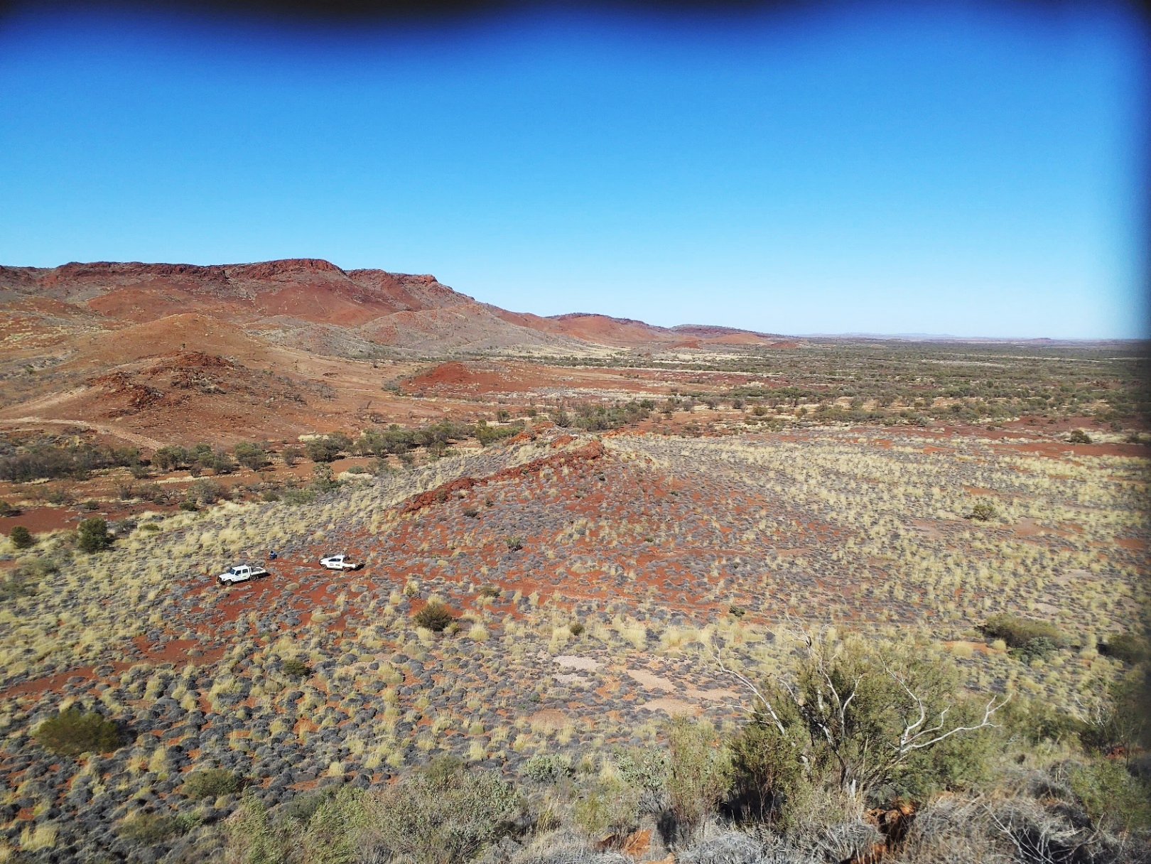
Photo during reconnaissance at Wyloo SE, looking southwest from the mapped rhyolite dome.
PERTH, Australia, Feb. 09, 2026 (GLOBE NEWSWIRE) -- Novo Resources Corp. (Novo or the Company) (ASX: NVO) (TSX: NVO) (OTCQB: NSRPF) is pleased to provide an update on the Wyloo Project, including recent exploration results and forward work program. This includes a heritage survey in March followed by a maiden RC program of some 1,500 m planned for Q2 2026 and designed to test the Wyloo SE polymetallic vein system.
Commenting on the Company’s exploration results and planned RC drilling, Mike Spreadborough, Executive Co-Chairman and Acting Chief Executive Officer, said: “The results from Wyloo SE continue to impress, with recent soil sampling defining a strong, open-ended multielement anomaly over a known polymetallic vein system. These results enhance our confidence in the scale and prospectivity of the target, and we are very excited about the conducting the maiden drill program into this compelling target.
Additionally, follow-up stream sediment sampling at Wyloo SW has expanded and strengthened the original stream sediment anomaly and has elevated Wyloo SW to a drill-ready prospect. This reinforces the broader potential of the Wyloo Project, with multiple targets now emerging for systematic drill testing.”

Figure 1: Novo Pilbara and Onslow District tenure showing significant prospects and location of the Wyloo Project in the southern Pilbara.
Regional Setting
The Wyloo project area covers two exploration tenements in the southern Pilbara (Figure 1). The Wyloo SE and SW prospects lie within the core of the Wyloo anticline, in the SE flank of the Wyloo Dome, which forms a basement high within the Ashburton Basin. It is a dynamic tectonic setting, with the regional Nanjilgardy Fault just 5 km south of the prospect. The Paulsons gold deposit lies in the NE part of the Wyloo Dome, approximately 40 km WNW of Wyloo SE.
Background 1, 2
Two significant antimony anomalies were located by Novo in the SE part of Wyloo tenement E47/4213 during routine stream sediment sampling in 2023.
Reconnaissance exploration on the eastern-most anomaly identified a zone of quartz-sulphide veining with anomalous antimony, silver, gold and base metals, at Wyloo SE (Figure 2). Seven rock chip samples yielded peak assay results of 387 g/t Ag, 0.38% Sb, 5.0% Pb, 1.6% Zn, 2.4% Cu and 0.52 g/tAu1.
Follow-up work in mid-2025 included detailed structural and regolith mapping and rock chip sampling. The latter focussed on the ENE trending vein array dipping 60 degree to the ESE for over 130 m strike and trending under cover to the SW and NE. The main vein array outcrop is up to 7 metres thick, with footwall/hangingwall zones of intense sulphide, alteration and numerous anastomsing veins; and is up to 18 m wide where exposed at surface. Rock chip sampling further enhanced the target and yielded maximum values of 482 g/t Ag, 1.29% Sb, 9.7% Pb, 16% Zn and 0.93 ppm Au2. Several samples assayed at greater than 7% Zn.
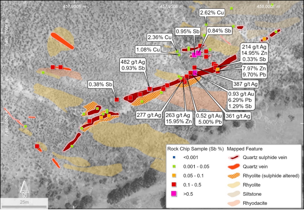
Figure 2: Previously released peak rock chip results at the Wyloo SE prospect and geology (outcrop mapping), highlighting significant Ag, Sb, Au, Cu, Zn and Pb results from the main vein array. Much of the target area only poorly outcrops (refer Figure 3 for geological setting).1,2
Mapping at Wyloo SE has highlighted a dynamic geological setting (Figure 3):
- The vein array is located on the flank of an interpreted rhyolite dome;
- The vein array is parallel to a significant fault zone (the Tasha Fault) to the immediate southeast;
- Presence of several subvolcanic intrusions including quartz-eye porphyry with disseminated malachite ex-sulphide (note - outcrop too small to delineate at this scale) and rhyodacite-quartz porphyry;
- Jasperoidal lenses containing disseminated sulphides are either replacement or exhalitive.
Wyloo Project New Results
Recent work includes a soil grid over the Wyloo SE vein system and surrounds; and detailed infill stream sediment sampling, rock chip sampling and mapping at Wyloo SW.
This recent exploration has significantly enhanced the potential of the project, provided new targets and has allowed interpretation of several targets ready to drill in Q2 2026.
Wyloo SE
One hundred and sixty two (162) minus 80 mesh soil samples were taken at a 40 x 20 m spacing over the target area to test for mineralisation outside the obvious vein array outcrops. Sampling was restricted in places by significant colluvial cover to the west and southwest, and by alluvium along the Tasha Fault from the south to the northeast.
A strong multielement soil anomaly has been defined over 150 m strike tending parallel to stratigraphy and crosscutting the main vein array, suggesting a stratigraphic control to the anomany and target. Peak soil values include 57.2 ppm Ag, 142 ppm Sb, 1,440 ppm As, 2,180 ppm Zn and 1,530 ppm Pb. Multielement anomalies are zoned, generally trend WNW parallel to the rhyolitic volcanic stratigraphy and are open under cover (Figure 3).
Refer to Appendix 1 for full results.
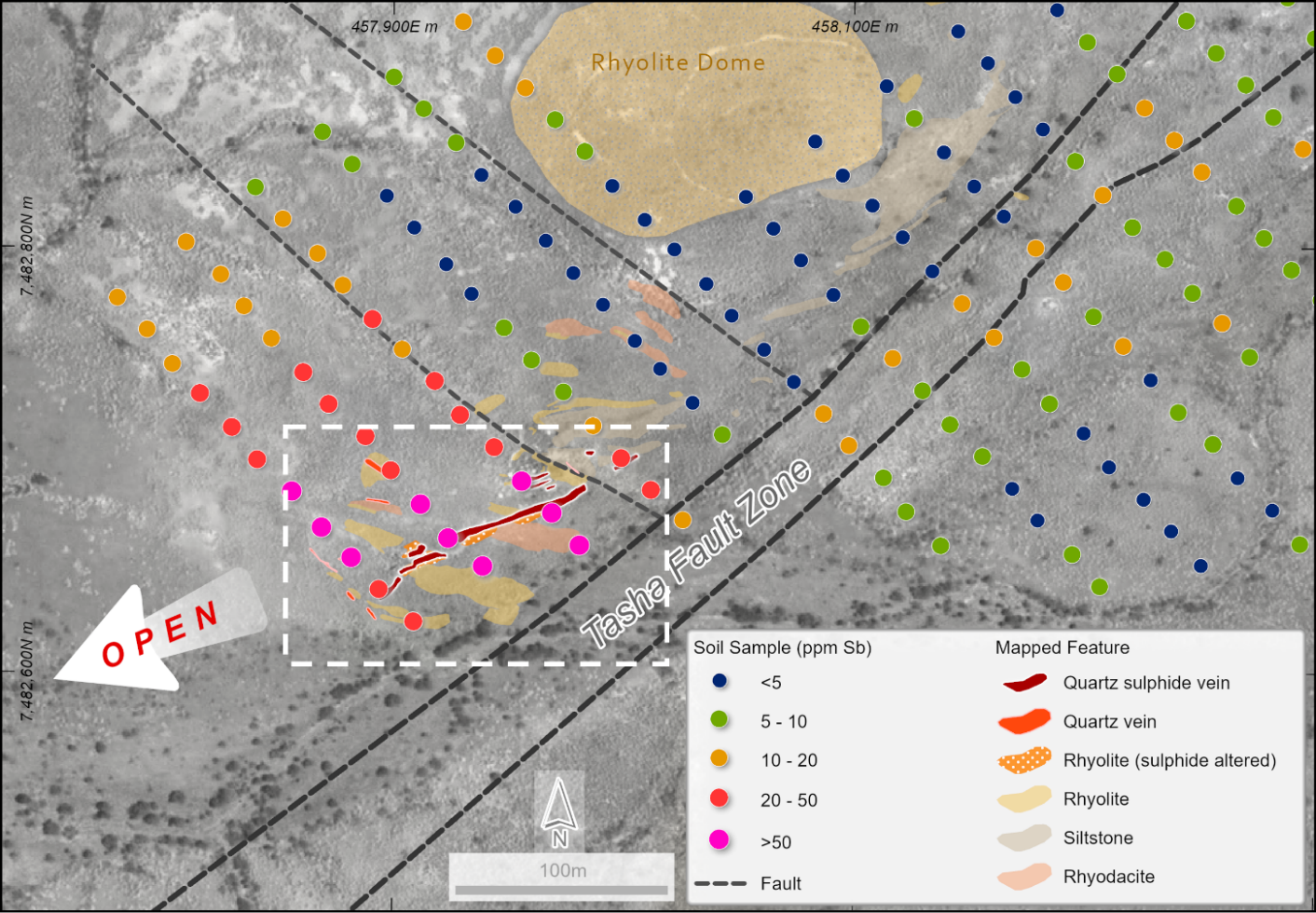
Figure 3, Wyloo SE highlighting geology, soil geochemistry (Sb ppm) and structural setting. Soil anomalies are open under colluvium to the west and alluvium along the Tasha Fault Zone to the east-northeast. The multielement anomalies trend NE to E-W, oblique to the main vein array. White dashed polygon shows field of view close-up from Figure 2.
Maiden drilling at Wyloo SE is planned to target:
- The main ENE trending polymetallic vein array
- The Tasha Fault zone, also trending ENE
- The WNW trending stratigraphy, particularly at the intersection and in the vicinity of the sulphide bearing quartz-eye porphyry.
Wyloo SW
Fifty four (54) stream sediment samples were collected at the Wyloo SW prospect, targeting first to third-order creeks to define the source of the existing stream sediment anomaly in an area of significant transported sheetwash cover.
This follow-up exploration has defined a target area of 2.5 km x 800 m with peak stream sediment values of 19.9 ppm Sb and 57 ppm As and a multielement association of Sb-As-Cu-Pb-Zn (Figure 4). Refer to Appendix 2 for full results.
Targeted selective rock chip sampling was completed over areas of outcrop, with 53 rock chip samples collected across the prospect area, targeting outcrop zones of alteration and prospective quartz veining. Refer to Appendix 3 for full results.
Within the newly defined 2.5 km x 800 m target area, only 2 small zones of outcrop are exposed in and adjacent to a NW trending creek. One of the zones is characterised by strong shearing containing a mix of schistose lithologies, vein arrays and carbonate alteration. Results from rock chip sampling highlight elevated Sb, As, Zn and Cu in outcrop, with peak results of 570 ppm As, 526 ppm Cu, 431 ppm Zn and 26 ppm Sb. Whilst these results are low tenor, they clearly indicate that a mineralising system is present. Follow-up work is requirted to define the source of the stream sediment anomaly.
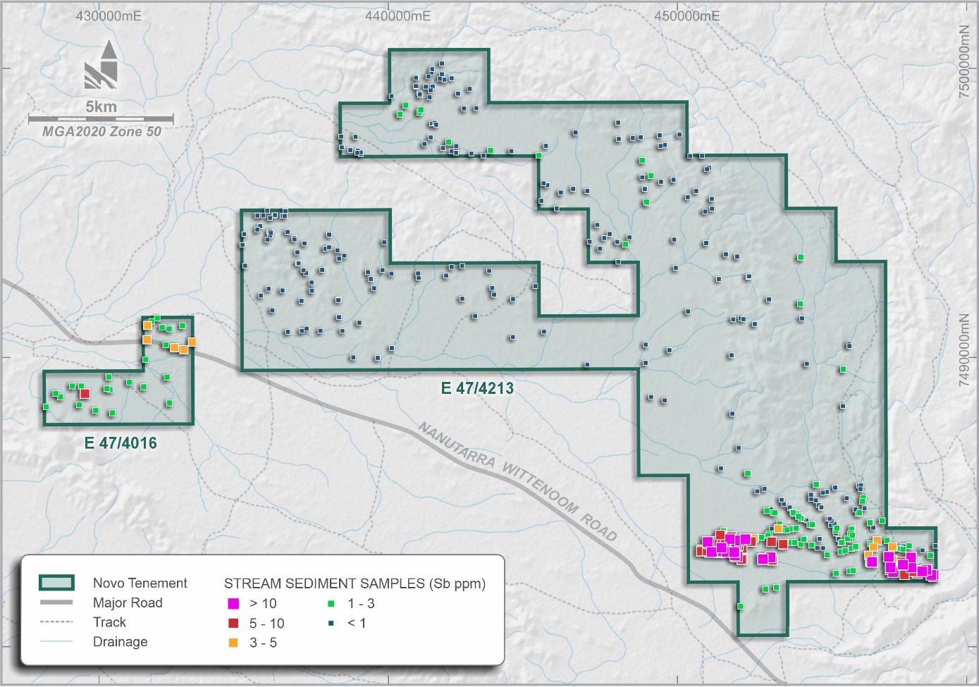
Figure 4 Wyloo tenure showing high order stream sediment antimony anomalies in the southern sector of the tenement, including recently received data for the Wyloo SW anomaly
Forward Program
A maiden drilling program at Wyloo SE is planned for Q2 2026 pending heritage surveys scheduled for early March. Drilling will target the ENE trending vein array, the Tasha Fault Zone and soil anomalies parallel to stratigraphy. Sectional drilling will test the vertical metal zonation of the polymetallic system, grade and width of the mineralisation and potentail plunge of the target.
Further work at Wyloo SW will require broad sectional drilling using either AC or RC drilling to test beneath the 1 – 3 m thick sheetwash colluvial cover.
Authorised for release by the Board of Directors.
CONTACT
Investors:
Mike Spreadborough
+61 8 6400 6100
info@novoresources.com | North American Queries:
Leo Karabelas
+1 416 543 3120
leo@novoresources.com | Media:
Cameron Gilenko
+61 466 984 953
cameron.gilenko@sodali.com |
QP STATEMENT
Mrs. Karen (Kas) De Luca (MAIG), is the qualified person, as defined under National Instrument 43-101 Standards of Disclosure for Mineral Projects, responsible for, and having reviewed and approved, the technical information contained in this news release. Mrs De Luca is Novo’s General Manager Exploration.
JORC COMPLIANCE STATEMENT
New Exploration Results
The information in this news release that relates to exploration results at Novo’s Pilbara tenure is based on information compiled by Mrs De Luca, who is a full-time employee of Novo Resources Corp. Mrs De Luca is a Competent Person who is a member of the Australian Institute of Geoscientists. Mrs De Luca has sufficient experience that is relevant to the style of mineralisation and the type of deposits under consideration and to the activity being undertaken to qualify as a Competent Person as defined in the 2012 Edition of the 'Australasian Code for Reporting of Exploration Results, Mineral Resources and Ore Reserves'. Mrs De Luca consents to the inclusion in the report of the matters based on her information in the form and context in which it appears.
Previous Exploration Results
The information in this news release that relates to previously reported exploration results at Novo’s Pilbara tenure is extracted from the Company’s ASX announcements referred to in endnotes 1 and 2, each of which is available to view at www.asx.com.au. The Company confirms that it is not aware of any new information or data that materially affects the information included in the original market announcements and that all material assumptions and technical parameters underpinning the estimates in the market announcements continue to apply and have not materially changed. The Company confirms that the form and context in which the competent persons findings are presented have not been materially modified from the original market announcements.
FORWARD-LOOKING STATEMENTS
Some statements in this news release may contain “forward-looking statements” within the meaning of Canadian and Australian securities law and regulations. In this news release, such statements include but are not limited to planned exploration activities and the timing of such. These statements address future events and conditions and, as such, involve known and unknown risks, uncertainties and other factors which may cause the actual results, performance or achievements to be materially different from any future results, performance or achievements expressed or implied by the statements. Such factors include, without limitation, customary risks of the resource industry and the risk factors identified in Novo’s annual information form for the year ended December 31, 2024 (which is available under Novo’s profile on SEDAR+ at www.sedarplus.ca and at www.asx.com.au) in the Company’s prospectus dated 2 August 2023 which is available at www.asx.com.au. Forward-looking statements speak only as of the date those statements are made. Except as required by applicable law, Novo assumes no obligation to update or to publicly announce the results of any change to any forward-looking statement contained or incorporated by reference herein to reflect actual results, future events or developments, changes in assumptions or changes in other factors affecting the forward-looking statements. If Novo updates any forward-looking statement(s), no inference should be drawn that the Company will make additional updates with respect to those or other forward-looking statements.
ABOUT NOVO
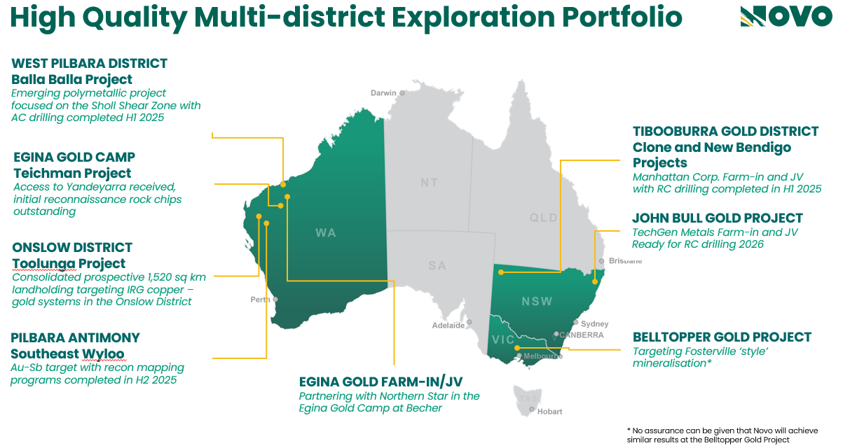
Novo is an Australian based gold explorer listed on the ASX and the TSX focussed on discovering standalone gold and copper projects with > 1 Moz development potential. Novo is an innovative explorer with a significant land package covering approximately 4,160 square kilometres in the Pilbara region of Western Australia, along with the 22 square kilometre Belltopper project in the Bendigo Tectonic Zone of Victoria. In addition to the above, Novo is part of two prospective farm in agreements in New South Wales.
Novo’s key project area in the Pilbara is the Egina Gold Camp, where Northern Star Resources Limited is farming-in to form a JV at the Becher Project and surrounding tenements through exploration expenditure of A$25 million for a 50% interest. The Becher Project has similar geological characteristics to Northern Star’s 13.6 Moz Hemi Project#. Novo is also advancing gold exploration south of Becher at the Teichman Project in the Egina Gold Camp, part of the Croydon JV (Novo 70%: Creasy Group 30%). Novo continues to undertake early-stage exploration elsewhere across its Pilbara tenement portfolio.
Novo has also formed a lithium joint venture with SQM in the Pilbara which provides shareholder exposure to battery metals.
Novo has strengthened its high-quality, Australian based exploration portfolio by adding the TechGen John Bull Gold Project in the New England Orogen of NSW, and Manhattan Corp. Limited Tibooburra Gold Project in the Albert Goldfields in northwestern NSW. Both projects demonstrate prospectivity for significant discovery and resource definition and align with Novo’s strategy of identifying and exploring projects with > 1 Moz Au potential. These high-grade gold projects compliment the landholding consolidation that forms the Toolunga Project in the Onslow District in Western Australia.
Novo has a significant investment portfolio and a disciplined program in place to identify value accretive opportunities that will build further value for shareholders.
Please refer to Novo’s website for further information including the latest corporate presentation.
#Refer to De Grey’s ASX Announcement, Hemi Gold Project mineral Resource Estimate (MRE) 2024, dated 14 November 2024. No assurance can be given that a similar (or any) commercially viable mineral deposit will be determined at Novo’s Becher Project.
Appendix 1: Wyloo SE new -80# soil sample results for Au, Ag, As, Cu, Pb, Sb, and Zn, relevant to the mineralisation style and reported in this release. All co-ordinates are in GDA2020 zone 50.
Sample
ID
| Easting
(m)
| Northing
(m)
| Height
(m)
| Au
(ppb)
| Ag
(ppm)
| As
(ppm)
| Cu
(ppm)
| Pb
(ppm)
| Sb
(ppm)
| Zn
(ppm)
|
| J1502b | 457948 | 7482762 | 296 | 7 | 0.0 | 37 | 50 | 11 | 5.1 | 130 |
| J1503b | 457960 | 7482747 | 298 | 2 | 0.1 | 37 | 56 | 13 | 6.5 | 62 |
| J1501b | 457934 | 7482778 | 295 | 2 | 0.3 | 25 | 45 | 12 | 4.4 | 103 |
| J1504b | 457974 | 7482732 | 303 | 4 | 0.2 | 57 | 55 | 16 | 6.6 | 71 |
| J1506b | 457999 | 7482701 | 302 | 2 | 1.2 | 174 | 272 | 63 | 41.5 | 112 |
| J1505b | 457987 | 7482716 | 307 | 1 | 0.1 | 67 | 65 | 20 | 10.3 | 119 |
| J1509b | 458043 | 7482712 | 296 | 1 | 0.1 | 47 | 44 | 31 | 5.3 | 79 |
| J1511b | 458016 | 7482743 | 297 | 3 | 0.1 | 42 | 38 | 11 | 3.4 | 106 |
| J1512b | 458005 | 7482756 | 296 | 0 | 0.1 | 31 | 51 | 11 | 2.8 | 115 |
| J1513b | 457991 | 7482773 | 292 | 1 | 0.1 | 28 | 53 | 10 | 2.5 | 131 |
| J1521b | 457913 | 7482865 | 292 | 2 | 0.2 | 72 | 107 | 11 | 7.3 | 40 |
| J1507b | 458012 | 7482686 | 297 | 1 | 1.1 | 205 | 120 | 106 | 34.0 | 110 |
| J1508b | 458026 | 7482672 | 295 | 2 | 0.2 | 47 | 66 | 14 | 11.7 | 104 |
| J1510b | 458030 | 7482727 | 295 | 1 | 0.1 | 27 | 34 | 14 | 3.9 | 60 |
| J1524b | 457944 | 7482890 | 295 | 3 | 0.1 | 60 | 56 | 13 | 18.4 | 53 |
| J1525b | 457957 | 7482875 | 296 | 2 | 0.2 | 60 | 80 | 12 | 16.8 | 50 |
| J1526b | 457970 | 7482860 | 301 | 2 | 1.3 | 18 | 76 | 11 | 8.9 | 61 |
| J1514b | 457978 | 7482788 | 291 | 1 | 0.0 | 18 | 36 | 9 | 2.8 | 118 |
| J1516b | 457966 | 7482803 | 293 | 1 | 0.1 | 17 | 43 | 9 | 2.7 | 139 |
| J1517b | 457953 | 7482819 | 293 | 2 | 0.3 | 49 | 51 | 9 | 3.2 | 128 |
| J1527b | 457983 | 7482845 | 302 | 1 | 0.3 | 18 | 61 | 11 | 5.7 | 49 |
| J1528b | 457995 | 7482829 | 301 | 0 | 0.2 | 18 | 38 | 10 | 3.1 | 59 |
| J1530b | 458022 | 7482799 | 301 | 0 | 0.0 | 35 | 85 | 8 | 4.2 | 28 |
| J1518b | 457938 | 7482834 | 291 | 2 | 0.1 | 31 | 79 | 13 | 4.8 | 101 |
| J1519b | 457927 | 7482849 | 292 | 1 | 0.1 | 88 | 68 | 11 | 8.0 | 56 |
| J1522b | 457900 | 7482880 | 294 | 0 | 0.1 | 36 | 44 | 11 | 7.7 | 46 |
| J1531b | 458036 | 7482783 | 301 | 5 | 0.3 | 34 | 161 | 9 | 3.1 | 126 |
| J1534b | 458074 | 7482737 | 300 | 3 | 0.2 | 41 | 54 | 22 | 4.7 | 46 |
| J1536b | 458087 | 7482722 | 300 | 0 | 0.0 | 63 | 71 | 30 | 10.8 | 48 |
| J1523b | 457930 | 7482906 | 297 | 0 | 0.0 | 28 | 30 | 12 | 11.5 | 48 |
| J1529b | 458009 | 7482813 | 300 | 1 | 0.1 | 29 | 71 | 9 | 3.8 | 50 |
| J1532b | 458047 | 7482768 | 301 | 2 | 0.0 | 33 | 35 | 12 | 3.1 | 81 |
| J1537b | 458098 | 7482707 | 299 | 4 | 0.0 | 74 | 108 | 46 | 12.4 | 63 |
| J1538b | 458113 | 7482692 | 300 | 4 | 0.1 | 60 | 78 | 19 | 7.1 | 104 |
| J1541b | 458207 | 7482641 | 303 | 1 | 0.1 | 28 | 53 | 8 | 5.2 | 85 |
| J1533b | 458061 | 7482752 | 301 | 2 | 0.2 | 39 | 37 | 17 | 3.8 | 51 |
| J1539b | 458123 | 7482676 | 302 | 1 | 0.0 | 59 | 73 | 18 | 8.3 | 109 |
| J1540b | 458138 | 7482660 | 300 | 1 | 0.2 | 43 | 71 | 9 | 9.6 | 123 |
| J1542b | 458195 | 7482656 | 303 | 0 | 0.1 | 25 | 47 | 8 | 5.1 | 77 |
| J1543b | 458180 | 7482672 | 302 | 2 | 0.1 | 32 | 49 | 8 | 4.6 | 102 |
| J1552b | 458077 | 7482794 | 306 | 1 | 0.0 | 32 | 46 | 11 | 3.1 | 58 |
| J1544b | 458169 | 7482687 | 302 | 2 | 0.1 | 49 | 127 | 10 | 3.6 | 121 |
| J1546b | 458156 | 7482702 | 303 | 3 | 0.3 | 43 | 102 | 27 | 6.8 | 99 |
| J1547b | 458142 | 7482717 | 302 | 7 | 0.2 | 79 | 82 | 17 | 7.0 | 94 |
| J1553b | 458065 | 7482809 | 306 | 1 | 0.1 | 31 | 56 | 10 | 2.7 | 47 |
| J1555b | 458108 | 7482820 | 313 | 2 | 0.0 | 71 | 56 | 8 | 3.9 | 19 |
| J1557b | 458134 | 7482789 | 303 | 1 | 0.0 | 38 | 47 | 14 | 4.4 | 32 |
| J1548b | 458130 | 7482733 | 304 | 7 | 0.2 | 66 | 68 | 40 | 9.3 | 80 |
| J1549b | 458117 | 7482748 | 303 | 1 | 0.0 | 77 | 81 | 44 | 13.5 | 53 |
| J1550b | 458103 | 7482763 | 304 | 4 | 0.1 | 49 | 93 | 33 | 6.1 | 42 |
| J1559b | 458161 | 7482758 | 303 | 12 | 0.2 | 77 | 60 | 43 | 10.3 | 70 |
| J1560b | 458173 | 7482743 | 302 | 6 | 0.1 | 67 | 74 | 20 | 9.0 | 79 |
| J1561b | 458185 | 7482727 | 302 | 27 | 0.1 | 51 | 137 | 25 | 7.0 | 83 |
| J1551b | 458091 | 7482778 | 304 | 2 | 0.1 | 38 | 47 | 14 | 3.5 | 36 |
| J1554b | 458095 | 7482834 | 316 | 0 | 0.1 | 22 | 37 | 8 | 2.9 | 23 |
| J1556b | 458121 | 7482805 | 308 | 1 | 0.1 | 37 | 42 | 10 | 2.9 | 29 |
| J1564b | 458226 | 7482682 | 310 | 2 | 0.0 | 12 | 42 | 7 | 2.4 | 55 |
| J1566b | 458238 | 7482667 | 305 | 0 | 0.0 | 13 | 42 | 7 | 3.1 | 54 |
| J1567b | 458251 | 7482651 | 299 | 10 | 0.0 | 22 | 47 | 8 | 3.6 | 64 |
| J1558b | 458147 | 7482774 | 302 | 9 | 0.1 | 49 | 64 | 48 | 10.2 | 52 |
| J1562b | 458200 | 7482713 | 303 | 1 | 0.1 | 43 | 152 | 6 | 2.6 | 118 |
| J1563b | 458211 | 7482697 | 306 | 0 | 0.1 | 29 | 49 | 7 | 3.3 | 105 |
| J1569b | 458319 | 7482632 | 300 | 1 | 0.1 | 67 | 45 | 10 | 12.7 | 63 |
| J1571b | 458294 | 7482661 | 296 | 1 | 0.1 | 41 | 55 | 9 | 6.7 | 69 |
| J1573b | 458267 | 7482692 | 301 | 1 | 0.0 | 21 | 38 | 7 | 3.6 | 52 |
| J1568b | 458307 | 7482646 | 301 | 9 | 0.1 | 42 | 42 | 10 | 7.8 | 61 |
| J1572b | 458282 | 7482677 | 298 | 1 | 0.0 | 26 | 55 | 9 | 3.7 | 84 |
| J1575b | 458241 | 7482723 | 307 | 0 | 0.1 | 32 | 52 | 8 | 5.9 | 86 |
| J1574b | 458256 | 7482708 | 304 | 1 | 0.1 | 25 | 40 | 7 | 5.4 | 55 |
| J1576b | 458229 | 7482738 | 303 | 0 | 0.1 | 32 | 54 | 9 | 3.4 | 97 |
| J1578b | 458204 | 7482768 | 304 | 8 | 0.3 | 95 | 102 | 29 | 9.0 | 82 |
| J1577b | 458217 | 7482754 | 304 | 5 | 0.3 | 91 | 95 | 30 | 12.8 | 86 |
| J1579b | 458191 | 7482784 | 305 | 11 | 0.2 | 72 | 83 | 30 | 10.1 | 62 |
| J1581b | 458165 | 7482815 | 297 | 1 | 0.1 | 28 | 46 | 19 | 3.9 | 39 |
| J1580b | 458179 | 7482800 | 291 | 12 | 0.2 | 68 | 80 | 45 | 12.0 | 56 |
| J1584b | 458126 | 7482861 | 314 | 2 | 0.1 | 46 | 50 | 13 | 5.0 | 43 |
| J1586b | 458114 | 7482876 | 314 | 1 | 0.1 | 30 | 48 | 10 | 3.7 | 36 |
| J1582b | 458152 | 7482829 | 300 | 2 | 0.1 | 39 | 56 | 17 | 3.3 | 35 |
| J1583b | 458139 | 7482845 | 305 | 0 | 0.0 | 31 | 35 | 11 | 2.9 | 27 |
| J1590b | 458158 | 7482887 | 304 | 5 | 0.1 | 24 | 47 | 14 | 3.7 | 38 |
| J1587b | 458083 | 7482850 | 323 | 1 | 0.0 | 36 | 30 | 10 | 2.9 | 32 |
| J1588b | 458053 | 7482824 | 309 | 1 | 0.1 | 29 | 68 | 10 | 2.6 | 36 |
| J1589b | 458145 | 7482902 | 304 | 1 | 0.0 | 24 | 45 | 12 | 3.7 | 68 |
| J1591b | 458170 | 7482871 | 302 | 2 | 0.1 | 24 | 43 | 22 | 3.2 | 40 |
| J1594b | 458208 | 7482825 | 302 | 5 | 0.1 | 67 | 65 | 35 | 11.8 | 44 |
| J1596b | 458221 | 7482810 | 302 | 2 | 0.1 | 46 | 77 | 30 | 7.3 | 58 |
| J1592b | 458182 | 7482856 | 301 | 7 | 0.2 | 23 | 54 | 71 | 4.1 | 42 |
| J1593b | 458196 | 7482841 | 301 | 1 | 0.1 | 53 | 88 | 50 | 9.5 | 43 |
| J1599b | 458260 | 7482765 | 303 | 7 | 0.2 | 75 | 90 | 28 | 10.5 | 68 |
| J1597b | 458235 | 7482795 | 303 | 5 | 0.2 | 51 | 90 | 38 | 9.6 | 73 |
| J1598b | 458247 | 7482779 | 307 | 6 | 0.3 | 66 | 96 | 28 | 7.7 | 68 |
| J5309 | 457882 | 7482654 | 295 | 0 | 1.4 | 612 | 35 | 80 | 75.5 | 134 |
| J1600b | 458272 | 7482749 | 304 | 1 | 0.1 | 78 | 103 | 22 | 7.3 | 84 |
| J5308 | 457894 | 7482639 | 296 | 1 | 1.0 | 939 | 30 | 57 | 47.9 | 106 |
| J5314 | 457816 | 7482731 | 292 | 2 | 0.2 | 219 | 88 | 16 | 20.7 | 62 |
| J5310 | 457869 | 7482668 | 295 | 2 | 6.2 | 475 | 51 | 102 | 110.0 | 195 |
| J5311 | 457856 | 7482685 | 295 | 0 | 0.4 | 501 | 110 | 40 | 81.8 | 187 |
| J5312 | 457841 | 7482700 | 295 | 0 | 0.0 | 461 | 64 | 18 | 47.7 | 70 |
| J5313 | 457830 | 7482715 | 294 | 0 | 0.0 | 260 | 57 | 21 | 30.1 | 59 |
| J5316 | 457804 | 7482745 | 291 | 2 | 0.2 | 315 | 50 | 16 | 17.9 | 57 |
| J5317 | 457793 | 7482761 | 289 | 3 | 0.0 | 177 | 64 | 15 | 15.0 | 65 |
| J5319 | 457810 | 7482802 | 290 | 1 | 0.0 | 263 | 66 | 17 | 17.8 | 62 |
| J5322 | 457835 | 7482772 | 296 | 0 | 0.1 | 215 | 57 | 15 | 14.5 | 55 |
| J5328 | 457912 | 7482679 | 300 | 1 | 0.8 | 224 | 116 | 59 | 89.8 | 222 |
| J5318 | 457780 | 7482776 | 289 | 105 | 0.1 | 110 | 39 | 13 | 11.6 | 52 |
| J5321 | 457825 | 7482787 | 293 | 1 | 0.0 | 317 | 61 | 15 | 14.1 | 55 |
| J5323 | 457847 | 7482757 | 293 | 1 | 0.0 | 299 | 36 | 12 | 17.6 | 43 |
| J5329 | 457924 | 7482663 | 302 | 1 | 57.2 | 1440 | 82 | 1530 | 142.0 | 255 |
| J5334 | 457956 | 7482690 | 304 | 0 | 0.2 | 376 | 474 | 16 | 111.5 | 162 |
| J5339 | 457904 | 7482752 | 292 | 16 | 0.1 | 97 | 100 | 12 | 18.6 | 72 |
| J5341 | 457878 | 7482782 | 294 | 7 | 0.5 | 291 | 64 | 11 | 12.6 | 63 |
| J5344 | 457840 | 7482828 | 292 | 1 | 0.1 | 196 | 95 | 14 | 7.9 | 56 |
| J5346 | 457869 | 7482854 | 291 | 1 | 0.1 | 77 | 68 | 12 | 5.3 | 84 |
| J5347 | 457882 | 7482839 | 292 | 0 | 0.0 | 103 | 34 | 9 | 5.9 | 75 |
| J5359 | 458201 | 7482897 | 303 | 2 | 0.1 | 36 | 54 | 24 | 5.4 | 41 |
| J5360 | 458188 | 7482912 | 305 | 4 | 0.2 | 30 | 73 | 24 | 4.4 | 51 |
| J5361 | 458176 | 7482927 | 303 | 1 | 0.0 | 24 | 39 | 16 | 3.2 | 39 |
| J5363 | 458217 | 7482938 | 304 | 1 | 0.1 | 40 | 65 | 26 | 6.6 | 39 |
| J5364 | 458231 | 7482923 | 308 | 1 | 0.0 | 41 | 81 | 27 | 7.2 | 33 |
| J5366 | 458244 | 7482907 | 306 | 2 | 0.2 | 44 | 56 | 23 | 7.6 | 36 |
| J5367 | 458257 | 7482892 | 303 | 4 | 0.2 | 59 | 67 | 29 | 9.2 | 42 |
| J5371 | 458295 | 7482847 | 310 | 7 | 0.3 | 93 | 138 | 54 | 10.8 | 63 |
| J5324 | 457861 | 7482741 | 295 | 1 | 0.1 | 391 | 70 | 16 | 22.4 | 67 |
| J5325 | 457872 | 7482726 | 296 | 0 | 0.0 | 254 | 113 | 15 | 30.2 | 71 |
| J5326 | 457888 | 7482711 | 296 | 1 | 0.2 | 446 | 125 | 24 | 41.2 | 93 |
| J5373 | 458321 | 7482816 | 307 | 5 | 0.2 | 56 | 62 | 23 | 12.4 | 52 |
| J5374 | 458353 | 7482841 | 312 | 1 | 0.2 | 32 | 58 | 20 | 8.4 | 52 |
| J5375 | 458341 | 7482856 | 316 | 1 | 0.1 | 34 | 47 | 19 | 4.9 | 52 |
| J5376 | 458326 | 7482872 | 309 | 9 | 0.2 | 38 | 81 | 27 | 7.1 | 55 |
| J5377 | 458313 | 7482887 | 305 | 0 | 0.1 | 45 | 68 | 25 | 7.9 | 49 |
| J5380 | 458275 | 7482933 | 305 | 1 | 0.0 | 51 | 61 | 21 | 8.8 | 36 |
| J5327 | 457899 | 7482695 | 299 | 1 | 0.1 | 197 | 153 | 27 | 44.0 | 103 |
| J5330 | 457939 | 7482650 | 304 | 0 | 1.8 | 422 | 50 | 148 | 79.0 | 2180 |
| J5331 | 457909 | 7482624 | 297 | 1 | 1.8 | 465 | 61 | 26 | 24.7 | 634 |
| J5332 | 457981 | 7482660 | 297 | 4 | 5.2 | 401 | 123 | 197 | 101.0 | 1290 |
| J5333 | 457969 | 7482675 | 301 | 2 | 1.0 | 349 | 125 | 204 | 120.5 | 305 |
| J5336 | 457944 | 7482706 | 302 | 2 | 0.2 | 268 | 167 | 20 | 34.5 | 82 |
| J5381 | 458262 | 7482949 | 302 | 1 | 0.0 | 37 | 84 | 16 | 5.7 | 37 |
| J5382 | 458248 | 7482963 | 305 | 3 | 0.1 | 37 | 62 | 23 | 5.3 | 38 |
| J5383 | 458234 | 7482978 | 300 | 3 | 0.1 | 42 | 87 | 38 | 6.3 | 36 |
| J5337 | 457929 | 7482721 | 300 | 0 | 0.0 | 95 | 95 | 12 | 22.8 | 91 |
| J5338 | 457918 | 7482737 | 297 | 1 | 0.1 | 56 | 93 | 16 | 20.5 | 65 |
| J5340 | 457891 | 7482766 | 290 | 10 | 0.2 | 337 | 83 | 11 | 20.4 | 67 |
| J5342 | 457867 | 7482797 | 293 | 0 | 0.1 | 1030 | 55 | 15 | 17.6 | 68 |
| J5343 | 457852 | 7482813 | 291 | 0 | 0.0 | 296 | 57 | 10 | 14.0 | 75 |
| J5348 | 457897 | 7482824 | 291 | 0 | 0.0 | 140 | 38 | 10 | 4.8 | 107 |
| J5349 | 457909 | 7482809 | 293 | 1 | 0.1 | 42 | 47 | 12 | 4.1 | 102 |
| J5350 | 457923 | 7482792 | 295 | 2 | 0.1 | 38 | 59 | 11 | 4.5 | 139 |
| J5351 | 458303 | 7482776 | 305 | 1 | 0.2 | 70 | 106 | 15 | 5.1 | 135 |
| J5352 | 458290 | 7482790 | 309 | 19 | 0.2 | 73 | 82 | 17 | 7.8 | 94 |
| J5353 | 458278 | 7482805 | 312 | 7 | 0.1 | 123 | 90 | 22 | 7.6 | 74 |
| J5354 | 458266 | 7482820 | 308 | 3 | 0.2 | 62 | 83 | 30 | 8.9 | 50 |
| J5355 | 458251 | 7482836 | 307 | 2 | 0.1 | 59 | 66 | 31 | 10.2 | 50 |
| J5356 | 458239 | 7482851 | 304 | 3 | 0.2 | 75 | 65 | 34 | 10.3 | 53 |
| J5357 | 458226 | 7482866 | 304 | 5 | 0.2 | 71 | 241 | 93 | 11.9 | 46 |
| J5358 | 458214 | 7482882 | 302 | 0 | 0.1 | 49 | 73 | 28 | 8.3 | 39 |
| J5362 | 458206 | 7482953 | 303 | 2 | 0.0 | 38 | 62 | 20 | 5.9 | 36 |
| J5368 | 458270 | 7482877 | 306 | 2 | 0.1 | 71 | 63 | 28 | 9.3 | 50 |
| J5369 | 458282 | 7482862 | 306 | 4 | 0.1 | 79 | 63 | 31 | 9.7 | 49 |
| J5372 | 458308 | 7482832 | 312 | 11 | 0.3 | 72 | 107 | 27 | 12.2 | 36 |
| J5378 | 458300 | 7482899 | 302 | 5 | 0.2 | 44 | 77 | 25 | 6.7 | 48 |
| J5379 | 458288 | 7482918 | 302 | 12 | 0.5 | 48 | 104 | 26 | 5.5 | 26 |
Appendix 2: Wyloo new stream sediment sample results for Au, Ag, As, Cu, Pb Sb, and Zn, relevant to the mineralisation style and reported in this release. All co-ordinates are in GDA2020 zone 50.
Sample
ID
| Easting
(m)
| Northing
(m)
| Height
(m)
| Au
(ppm)
| Ag
(ppm)
| As
(ppm)
| Cu
(ppm)
| Pb
(ppm)
| Sb
(ppm)
| Zn
(ppm)
|
| BL0001 | 450821 | 7483293 | 248 | 0 | 0 | 27 | 49 | 19 | 6.6 | 101 |
| BL0002 | 450821 | 7483377 | 248 | 0.01 | 0 | 18 | 59 | 12 | 3.8 | 109 |
| BL0003 | 451043 | 7483614 | 246 | 0 | 0 | 50 | 69 | 24 | 11.7 | 144 |
| BL0004 | 451215 | 7483634 | 245 | 0 | 0 | 28 | 50 | 19 | 6.7 | 104 |
| BL0005 | 451120 | 7483396 | 246 | 0 | 0 | 24 | 57 | 15 | 6.3 | 126 |
| BL0006 | 451184 | 7483269 | 243 | 0.06 | 0.04 | 40 | 58 | 24 | 11.8 | 130 |
| BL0007 | 451143 | 7483266 | 245 | 0.03 | 0 | 29 | 48 | 20 | 8.4 | 110 |
| BL0008 | 451104 | 7483258 | 245 | 0 | 0 | 32 | 48 | 21 | 9.0 | 111 |
| BL0009 | 451022 | 7483298 | 243 | 0 | 0.07 | 31 | 53 | 21 | 9.8 | 125 |
| BL0010 | 450968 | 7483287 | 242 | 0.03 | 0.17 | 20 | 43 | 15 | 4.6 | 85 |
| BL0011 | 452290 | 7483617 | 250 | 0 | 0 | 12 | 40 | 12 | 3.1 | 75 |
| BL0012 | 452286 | 7483675 | 248 | 0 | 0.03 | 47 | 72 | 26 | 10.0 | 147 |
| BL0013 | 452160 | 7483672 | 249 | 0 | 0 | 49 | 77 | 28 | 11.5 | 164 |
| BL0014 | 452118 | 7483481 | 249 | 0 | 0.06 | 22 | 58 | 11 | 5.8 | 127 |
| BL0016 | 452232 | 7483359 | 253 | 0.01 | 0 | 20 | 62 | 11 | 4.5 | 128 |
| BL0017 | 452238 | 7483396 | 256 | 0.06 | 0 | 33 | 67 | 16 | 8.9 | 156 |
| BL0018 | 452909 | 7483774 | 253 | 0 | 0.08 | 6 | 48 | 13 | 1.4 | 78 |
| BL0019 | 452800 | 7483777 | 251 | 0 | 0 | 13 | 57 | 20 | 1.4 | 70 |
| BL0021 | 452652 | 7483748 | 253 | 0 | 0.19 | 25 | 84 | 36 | 4.4 | 100 |
| BL0022 | 452559 | 7483635 | 250 | 0 | 0.09 | 36 | 54 | 21 | 9.5 | 123 |
| BL0023 | 453607 | 7483449 | 259 | 0 | 0 | 6 | 38 | 11 | 1.0 | 64 |
| BL0024 | 453291 | 7482979 | 262 | 0 | 0 | 23 | 63 | 11 | 6.7 | 144 |
| BL0025 | 453219 | 7483084 | 261 | 0 | 0 | 55 | 93 | 23 | 14.1 | 189 |
| BL0026 | 451448 | 7483244 | 252 | 0.06 | 0.15 | 22 | 47 | 15 | 5.7 | 90 |
| BL0027 | 451567 | 7483301 | 251 | 0 | 0.14 | 48 | 67 | 26 | 15.1 | 155 |
| BL0028 | 451700 | 7483274 | 251 | 0.01 | 0.04 | 46 | 69 | 24 | 15.0 | 164 |
| BL0029 | 451991 | 7483151 | 252 | 0.04 | 0 | 57 | 80 | 26 | 19.9 | 199 |
| BL0030 | 451991 | 7483107 | 253 | 0 | 0 | 26 | 50 | 17 | 7.6 | 113 |
| BL0031 | 452068 | 7483115 | 252 | 0.06 | 0.06 | 54 | 77 | 27 | 19.2 | 186 |
| BL0032 | 452261 | 7483041 | 253 | 0 | 0 | 24 | 57 | 16 | 6.7 | 132 |
| BL0033 | 452226 | 7483006 | 254 | 0 | 0.04 | 20 | 51 | 13 | 5.8 | 113 |
| BL0034 | 452041 | 7483241 | 252 | 0 | 0 | 24 | 62 | 13 | 5.9 | 137 |
| BL0036 | 451961 | 7483265 | 254 | 0 | 0.15 | 39 | 75 | 19 | 11.4 | 171 |
| BL0037 | 451648 | 7483562 | 249 | 0.04 | 0 | 30 | 69 | 14 | 9.1 | 152 |
| BL0038 | 451524 | 7483420 | 254 | 0.05 | 0 | 35 | 66 | 18 | 11.5 | 159 |
| BL0039 | 453000 | 7483050 | 255 | 0 | 0.03 | 32 | 80 | 16 | 9.0 | 170 |
| BL0040 | 452952 | 7483022 | 252 | 0.03 | 0.06 | 46 | 78 | 24 | 15.2 | 175 |
| BL0041 | 451618 | 7484016 | 247 | 0 | 0 | 11 | 41 | 17 | 1.5 | 69 |
| BL0042 | 451593 | 7484011 | 246 | 0.03 | 0.09 | 13 | 39 | 21 | 2.2 | 65 |
| BL0043 | 451479 | 7483864 | 244 | 0.01 | 0.09 | 24 | 48 | 23 | 5.9 | 105 |
| BL0044 | 451528 | 7483862 | 242 | 0 | 0 | 19 | 52 | 20 | 3.6 | 85 |
| BL0046 | 451819 | 7483754 | 248 | 0.04 | 0.04 | 23 | 54 | 17 | 4.5 | 90 |
| BL0047 | 451838 | 7483813 | 248 | 0.05 | 0 | 26 | 57 | 21 | 5.9 | 103 |
| BL0048 | 451866 | 7483805 | 245 | 0 | 0 | 31 | 62 | 23 | 6.2 | 109 |
| BL0049 | 452347 | 7483716 | 253 | 0 | 0.16 | 41 | 68 | 24 | 10.2 | 125 |
| BL0050 | 452424 | 7483720 | 252 | 0.02 | 0 | 27 | 61 | 18 | 4.2 | 88 |
| BL0051 | 453265 | 7484081 | 259 | 0.05 | 0.11 | 6 | 48 | 12 | 0.9 | 89 |
| BL0052 | 453186 | 7483911 | 256 | 0 | 0.04 | 6 | 52 | 15 | 1.6 | 80 |
| BL0053 | 453128 | 7483848 | 258 | 0 | 0 | 6 | 41 | 12 | 1.3 | 65 |
| BL0054 | 453255 | 7483626 | 257 | 0.08 | 0.11 | 19 | 50 | 23 | 5.1 | 96 |
Appendix 3: Wyloo rock sample results for Au, Ag, As, Cu, Pb Sb, and Zn, relevant to the mineralisation style and reported in this release. All co-ordinates are in GDA2020 zone 50.
Sample
ID | Easting
(m) | Northing
(m) | Height
(m) | Au
(ppm) | Ag
(ppm) | As
(ppm) | Cu
(ppm) | Pb
(ppm) | Sb
(ppm) | Zn
(ppm) |
| R07742 | 451229 | 7483662 | 243 | 0.001 | 0 | 0 | 15 | 0 | 0 | 15 |
| R07743 | 451336 | 7483643 | 243 | 0.004 | 0 | 43 | 78 | 10 | 0 | 63 |
| R07744 | 451613 | 7483613 | 247 | 0.001 | 0 | 11 | 11 | 2 | 0 | 10 |
| R07745 | 452649 | 7483245 | 254 | 0.058 | 0.5 | 92 | 383 | 47 | 0 | 19 |
| R07746 | 452645 | 7483894 | 241 | 0.003 | 0.7 | 105 | 64 | 3 | 0 | 165 |
| R07747 | 452577 | 7483766 | 241 | 0.012 | 0 | 13 | 15 | 5 | 0 | 13 |
| R07748 | 452531 | 7484213 | 244 | 0.002 | 0 | 19 | 25 | 7 | 0 | 76 |
| R07749 | 452409 | 7484339 | 242 | 0.004 | 0 | 80 | 77 | 7 | 6 | 142 |
| R07750 | 452377 | 7484430 | 241 | 0.002 | 0 | 11 | 45 | 43 | 0 | 154 |
| R07751 | 452568 | 7484709 | 238 | 0.002 | 0 | 9 | 28 | 21 | 0 | 9 |
| R07752 | 452366 | 7484700 | 240 | 0.002 | 0 | 16 | 42 | 9 | 0 | 13 |
| R07753 | 452292 | 7484684 | 246 | 0.003 | 0 | 7 | 9 | 3 | 0 | 62 |
| R07754 | 453019 | 7484238 | 239 | 0.001 | 0 | 70 | 18 | 6 | 0 | 63 |
| R07756 | 453030 | 7484233 | 242 | 0.002 | 0 | 45 | 25 | 5 | 0 | 60 |
| R07757 | 453024 | 7484237 | 250 | 0.001 | 0 | 0 | 2 | 0 | 0 | 3 |
| R07842 | 452381 | 7483373 | 255 | 0.004 | 0 | 17 | 27 | 27 | 12 | 90 |
| R07843 | 452715 | 7483228 | 259 | 0.001 | 0 | 425 | 23 | 3 | 10 | 108 |
| R07844 | 453251 | 7483102 | 262 | 0.004 | 0 | 464 | 232 | 42 | 26 | 431 |
| R07846 | 452745 | 7483196 | 255 | 0.006 | 0 | 29 | 66 | 3 | 0 | 46 |
| R07847 | 452776 | 7483146 | 254 | 0.001 | 0 | 40 | 110 | 73 | 8 | 37 |
| R07848 | 452771 | 7483140 | 256 | 0.003 | 0.8 | 570 | 149 | 5 | 5 | 31 |
| R07849 | 452785 | 7483124 | 254 | 0.002 | 0 | 41 | 70 | 4 | 0 | 22 |
| R07850 | 452812 | 7483117 | 257 | 0.001 | 0 | 42 | 61 | 149 | 0 | 55 |
| R07851 | 452802 | 7483148 | 256 | 0 | 0 | 195 | 26 | 19 | 0 | 17 |
| R07852 | 452749 | 7483193 | 258 | 0.003 | 0 | 130 | 138 | 4 | 0 | 45 |
| R07853 | 453721 | 7482414 | 272 | 0.009 | 0 | 231 | 6 | 5 | 12 | 16 |
| R07854 | 453812 | 7482548 | 273 | 0.033 | 0 | 87 | 27 | 27 | 0 | 34 |
| R07855 | 452792 | 7483160 | 259 | 0.009 | 0 | 112 | 114 | 3 | 0 | 56 |
| R07856 | 452791 | 7483162 | 261 | 0 | 0 | 90 | 12 | 3 | 0 | 33 |
| R07857 | 452372 | 7483397 | 270 | 0.007 | 0 | 41 | 303 | 57 | 24 | 17 |
| R07859 | 452469 | 7483278 | 257 | 0 | 0 | 8 | 32 | 2 | 0 | 11 |
| R08646 | 452093 | 7483569 | 253 | 0.013 | 0.8 | 40 | 102 | 41 | 14 | 119 |
| R08647 | 452354 | 7483417 | 254 | 0.001 | 0 | 68 | 74 | 12 | 21 | 64 |
| R08648 | 452348 | 7483422 | 256 | 0 | 0 | 20 | 12 | 93 | 6 | 28 |
| R08649 | 452378 | 7483396 | 256 | 0.007 | 0 | 66 | 526 | 32 | 24 | 57 |
| R09051 | 453038 | 7484092 | 246 | 0.001 | 0 | 8 | 10 | 9 | 0 | 22 |
| R09053 | 453417 | 7483771 | 245 | 0.001 | 0 | 0 | 21 | 34 | 0 | 325 |
| R09054 | 453491 | 7483933 | 247 | 0 | 0 | 5 | 22 | 2 | 5 | 4 |
| R09055 | 453020 | 7483892 | 244 | 0 | 0 | 36 | 19 | 3 | 0 | 25 |
| R09056 | 453027 | 7483903 | 245 | 0.009 | 0 | 14 | 82 | 18 | 0 | 50 |
| R09057 | 452979 | 7483960 | 244 | 0 | 0 | 6 | 41 | 5 | 0 | 21 |
| R09058 | 452913 | 7483852 | 244 | 0 | 0 | 16 | 9 | 4 | 11 | 7 |
| R09059 | 453002 | 7483916 | 245 | 0 | 0 | 0 | 46 | 3 | 0 | 19 |
| R09060 | 453015 | 7483914 | 245 | 0 | 0 | 15 | 30 | 3 | 0 | 16 |
| R09062 | 453006 | 7483921 | 244 | 0.023 | 0 | 34 | 886 | 11 | 0 | 60 |
| R09063 | 453516 | 7484110 | 253 | 0 | 0 | 0 | 10 | 0 | 0 | 5 |
| R09064 | 453457 | 7484191 | 251 | 0 | 0 | 0 | 4 | 3 | 0 | 4 |
| R09065 | 453149 | 7484276 | 250 | 0.001 | 0 | 0 | 12 | 3 | 0 | 5 |
| R09066 | 453165 | 7484315 | 252 | 0.001 | 0 | 13 | 116 | 46 | 0 | 98 |
| R09067 | 453063 | 7484333 | 254 | 0.04 | 2.7 | 0 | 85 | 4260 | 6 | 9 |
| R09068 | 453091 | 7484197 | 253 | 0 | 0 | 0 | 7 | 16 | 0 | 53 |
| R09069 | 453135 | 7484141 | 250 | 0 | 0 | 10 | 21 | 4 | 0 | 40 |
| R09070 | 453153 | 7484128 | 251 | 0.001 | 0 | 22 | 72 | 133 | 0 | 52 |
JORC Code, 2012 Edition – Table 1
Section 1: Sampling Techniques and Data
(Criteria listed in the preceding section also apply to this section)
| Criteria | JORC Code explanation | Commentary |
| Sampling techniques | - Nature and quality of sampling (e.g., cut channels, random chips, or specific specialised industry standard measurement tools appropriate to the minerals under investigation, such as down hole gamma sondes, or handheld XRF instruments, etc). These examples should not be taken as limiting the broad meaning of sampling.
- Include reference to measures taken to ensure sample representivity and the appropriate calibration of any measurement tools or systems used.
- Aspects of the determination of mineralisation that are Material to the Public Report.
- In cases where ‘industry standard’ work has been done this would be relatively simple (e.g., ‘reverse circulation drilling was used to obtain 1 m samples from which 3 kg was pulverised to produce a 30 g charge for fire assay’). In other cases, more explanation may be required, such as where there is coarse gold that has inherent sampling problems. Unusual commodities or mineralisation types (e.g., submarine nodules) may warrant disclosure of detailed information.
| - Wyloo rock chips samples were collected by grab sampling 1 – 3 kg of material from outcrop. Sample sites were selected to be representative of the lithology sampled, and the same sampling technique was employed at each sample site where possible. Samples are pulverised in full and analysed for gold using a 50 g charge fire assay with ICP finish and for multi-elements using aqua regia digest with a 0.25 g charge.
- Wyloo soil samples of approximately 150 g of material were collected from 2 cm – 20 cm depth and sieved to <80# on a 40 m x 20 m grid. No sample preparation was conducted on this fine fraction except for drying. All soils were analysed via aqua regia digest for multielements and Au using a 0.25 g charge.
- Wyloo stream sediment samples were collected from non-trap sites in straight section of the river from active river gravels, with approximately 500 g of material sieved to <0.9 mm. The sample was pulverised in full and analysed via aqua regia digest using a 0.25 g charge for multielements. Samples were also assayed via cyanide leach for both gold and silver, with a sample size up to 1 kg
|
| Drilling techniques | - Drill type (e.g., core, reverse circulation, open-hole hammer, rotary air blast, auger, Bangka, sonic, etc) and details (e.g., core diameter, triple or standard tube, depth of diamond tails, face-sampling bit, or other type, whether core is oriented and if so, by what method, etc).
| - Not applicable as no drilling undertaken
|
| Drill sample recovery | - Method of recording and assessing core and chip sample recoveries and results assessed.
- Measures taken to maximise sample recovery and ensure representative nature of the samples.
- Whether a relationship exists between sample recovery and grade and whether sample bias may have occurred due to preferential loss/gain of fine/coarse material.
| - Not applicable as no drilling undertaken.
|
| Logging | - Whether core and chip samples have been geologically and geotechnically logged to a level of detail to support appropriate Mineral Resource estimation, mining studies and metallurgical studies.
- Whether logging is qualitative or quantitative in nature. Core (or costean, channel, etc) photography.
- The total length and percentage of the relevant intersections logged.
| - Rock chip samples are geologically logged with quantitative and qualitative data collected including a description of lithology, vein type and vein densities, and alteration.
|
| Sub-sampling techniques and sample preparation | - If core, whether cut or sawn and whether quarter, half or all core taken.
- If non-core, whether riffled, tube sampled, rotary split, etc and whether sampled wet or dry.
- For all sample types, the nature, quality, and appropriateness of the sample preparation technique.
- Quality control procedures adopted for all sub-sampling stages to maximise representivity of samples.
- Measures taken to ensure that the sampling is representative of the in-situ material collected, including for instance results for field duplicate/second-half sampling.
- Whether sample sizes are appropriate to the grain size of the material being sampled.
| - The sampling techniques and sample sizes are considered appropriate for methodologies adopted for sample preparation and assaying and the style of mineralisation and sample medium.
- Rock chip samples are collected to best represent the material sampled across geological features. The method includes inserting 2 CRM standards and 2 blanks per 100 samples or at least one of each per sample submission.
- Soil sampling uses a -80# sieve size resulting in an approximately 120 g sample which is considered appropriate to the material being sampled. The method includes insertion of at least 2 blanks 2 CRM standards and 4 field duplicates per 100 samples.
- Stream sediment sampling uses a <0.9 mm sieve size resulting in a sample of approximately 500 g which is considered appropriate for the material being sampled. The method includes insertion of at least 2 blanks 2 CRM standards and 4 field duplicates per 100 samples.
|
| Quality of assay data and laboratory tests | - The nature, quality and appropriateness of the assaying and laboratory procedures used and whether the technique is considered partial or total.
- For geophysical tools, spectrometers, handheld XRF instruments, etc, the parameters used in determining the analysis including instrument make and model, reading times, calibrations factors applied and their derivation, etc.
- Nature of quality control procedures adopted (e.g., standards, blanks, duplicates, external laboratory checks) and whether acceptable levels of accuracy (if lack of bias) and precision have been established.
| - The rock chip sample preparation and sample assay methodology of fire assay is a total digest and considered appropriate for the style of mineralisation tested. Gold analysis was completed using Au-ICP22 method and for multi-elements by ME-ICP61. All assaying was completed by ALS in Perth (NATA Accreditation number 825).
- The soil and stream sediment sample assay methodology has low level detection for multielements and gold with partial digest and is considered appropriate for the style of mineralisation tested. All soils and streams were analysed using AuME-TL43 method. In addition, stream sediment samples were also assayed for Au and Ag, Au-AA14 and Ag-AA14 respectively. All analysis was completed by ALS in Perth (NATA Accreditation number 825).
- No QAQC issues were detected for Au or ME performance for any sample type, with CRM performance passing review and no bias detected.
|
| Verification of sampling and assaying | - The verification of significant intersections by either independent or alternative company personnel.
- The use of twinned holes.
- Documentation of primary data, data entry procedures, data verification, data storage (physical and electronic) protocols.
- Discuss any adjustment to assay data.
| - Primary data was collected in the field and stored using database compatible excel templates which were then forwarded to the database manager email for upload to the Geobank (v2025) database, buffered through a validation portal that ensures code and primary record compliance. Geobank is a front-end UX/UI tender software platform (developed and sold by Micromine) attached to a SQL v15.1 server.
- Assay data was loaded from lab certificates received from the registered laboratory by an internal database manager or external database consultant, and industry-standard audit trails and chain-of-custody was adhered to.
- No adjustments of the assay data were made.
|
| Location of data points | - Accuracy and quality of surveys used to locate drill holes (collar and down-hole surveys), trenches, mine workings and other locations used in Mineral Resource estimation.
- Specification of the grid system used.
- Quality and adequacy of topographic control.
| - All surface sample locations and mapping features, including veins and rocks were recorded by hand-held GPS using the GDA 2020 zone 50 coordinate system.
|
| Data spacing and distribution | - Data spacing for reporting of Exploration Results.
- Whether the data spacing, and distribution is sufficient to establish the degree of geological and grade continuity appropriate for the Mineral Resource and Ore Reserve estimation procedure(s) and classifications applied.
- Whether sample compositing has been applied.
| - Limited rock chip samples taken are indicative of potential grade tenor. These do not represent or imply any continuity or scale potential.
|
| Orientation of data in relation to geological structure | - Whether the orientation of sampling achieves unbiased sampling of possible structures and the extent to which this is known, considering the deposit type.
- If the relationship between the drilling orientation and the orientation of key mineralised structures is considered to have introduced a sampling bias, this should be assessed and reported if material.
| - Rock samples were taken across features with geological data recorded to best reflect unbiased sampling of possible mineralised structures.
|
| Sample security | - The measures taken to ensure sample security.
| - All samples are stored and managed on site by internal staff. Samples are then transported by reputable companies to a registered laboratory where they are stored in a locked facility before being tracked and processed through the preparation and analysis system at the laboratory.
|
| Audits or reviews | - The results of any audits or reviews of sampling techniques and data.
| - No audits have been undertaken.
|
Section 2: Reporting of Exploration Results
(Criteria listed in the preceding section also apply to this section)
| Criteria | JORC Code explanation | Commentary |
| Mineral tenement and land tenure status | - Type, reference name/number, location and ownership including agreements or material issues with third parties such as joint ventures, partnerships, overriding royalties, native title interests, historical sites, wilderness or national park and environmental settings.
- The security of the tenure held at the time of reporting along with any known impediments to obtaining a license to operate in the area.
| - The Wyloo project area is located in the Southern Pilbara and comprises two tenements, E47/4016 and E47/4213, held by Rocklea Gold Pty Ltd and Meentheena Gold Pty Ltd respectively; both Companies are wholly owned subsidiaries of Novo. The Tenure falls within the PKKP Native Title Determination. The tenements are currently in good standing and there are no known impediments.
|
| Exploration done by other parties | - Acknowledgment and appraisal of exploration by other parties.
| - The SE Wyloo prospect was discovered by Novo during a regional stream sediment sampling program across the E47/4213 tenement.
- No other known work of relevance has been undertaken by other parties.
|
| Geology | - Deposit type, geological setting, and style of mineralisation.
| - Mapping at SE Wyloo has highlighted a dynamic geological setting, with the vein arrays on the flank of an interpreted rhyolite dome and parallel to a significant fault zone. Soil sampling has highlighted a stratigraphic component to the mineralisation trend, and the target style is interpreted as VHMS or an intermediate sulphidation system. The target continues under cover along strike in both directions (SW and NE).
- Rock chip samples yielded maximum values of 0.93 g/t Au, 482 g/t Ag, 1.29% Sb, 9.7% Pb and 15.95% Zn with numerous high-grade samples along the outcropping vein array.
- Mapping at Wyloo SW has identified thick (>2m) cover across much of the target area, with occasional outcrops exposed in creeks. Mapping has highlighted a NW trending shear zone with quartz vein arrays and anomalous multielement geochemistry which has not adequately explained the broad anomalism. Novo believe that the target is under cover and not well exposed
|
| Drill hole Information | - A summary of all information material to the understanding of the exploration results including a tabulation of the following information for all Material drill holes, including Easting and northing of the drill hole collar, Elevation or RL (Reduced Level – elevation above sea level in metres) of the drill hole collar, dip and azimuth of the hole, down hole length and interception depth plus hole length.
- If the exclusion of this information is justified on the basis that the information is not Material and this exclusion does not detract from the understanding of the report, the Competent Person should clearly explain why this is the case.
| - All rock chip sample results are reported in Appendices, listing all significant multi-elements.
|
| Data aggregation methods | - In reporting Exploration Results, weighting averaging techniques, maximum and/or minimum grade truncations (e.g., cutting of high grades) and cut-off grades are usually Material and should be stated.
- Where aggregate intercepts incorporate short lengths of high-grade results and longer lengths of low-grade results, the procedure used for such aggregation should be stated and some typical examples of such aggregations should be shown in detail.
- The assumptions used for any reporting of metal equivalent values should be clearly stated.
| - Not applicable as no drilling undertaken.
|
| Relationship between mineralisation widths and intercept lengths | - These relationships are particularly important in the reporting of Exploration Results.
- If the geometry of the mineralisation with respect to the drill hole angle is known, its nature should be reported.
- If it is not known and only the down hole lengths are reported, there should be a clear statement to this effect (e.g., ‘down hole length, true width not known’).
| - Rock sample results are indicative in nature and, whilst representatively sampling the target lithology, do not contain any width or length information other than a qualitative description of the target.
|
| Diagrams | - Appropriate maps and sections (with scales) and tabulations of intercepts should be included for any significant discovery being reported. These should include but not be limited to a plan view of drill hole collar locations and appropriate sectional views.
| - Refer to the body of the release for appropriate maps and diagrams.
|
| Balanced reporting | - Where comprehensive reporting of all Exploration Results is not practicable, representative reporting of both low and high grades and/or widths should be practiced to avoid misleading reporting of Exploration Results.
| - The full multielement suite for rock chips comprises 34 elements with soil and stream sediment samples comprising 51 elements. Not all elements are reported in Appendix 1, but a selection relevant to the mineralisation style is reported. For these elements, sample ID, northing, easting and RL are reported.
- All rock sample results are reported.
|
| Other substantive exploration data | - Other exploration data, if meaningful and material, should be reported including (but not limited to): geological observations; geophysical survey results; geochemical survey results; bulk samples – size and method of treatment; metallurgical test results; bulk density, groundwater, geotechnical and rock characteristics; potential deleterious or contaminating substances.
| |
| Further work | - The nature and scale of planned further work (e.g., tests for lateral extensions or depth extensions or large-scale step-out drilling).
- Diagrams clearly highlighting the areas of possible extensions, including the main geological interpretations and future drilling areas, provided this information is not commercially sensitive.
| - Refer to the body of the release.
- Novo plans to complete a heritage survey in March 2026. Novo intends to complete a > 1,500 m maiden RC drilling program at the SE Wyloo prospect drilling N-S section lines to test both structural and stratigraphic targets near surface and at depth.
- In addition, further data review and interpretation for the Wyloo SW prospect is planned. The target requires heritage surveys prior to drilling, which would include angled traverses (likely N-S) using AC or RC drilling techniques to identify the source of the geochemical anomalism
|
No Section 3 or 4 report as no Mineral Resources or Ore Reserves are reported in this Appendix
1 Refer to Novo’s ASX announcement dated 12 September 2024 – Evaluation of Pilbara Antimony-Gold Potential Generates Positive Results
2 Refer to Novo’s ASX announcement dated 04 September 2025 – Drilling Commences at Sherlock Crossing Gold-Antimony Prospect
Photos accompanying this announcement are available at:
https://www.globenewswire.com/NewsRoom/AttachmentNg/53bbb178-0e06-439e-8bbf-4b45af3ba609
https://www.globenewswire.com/NewsRoom/AttachmentNg/37d23dfd-78d1-45a8-b2fc-9bc899480d83
https://www.globenewswire.com/NewsRoom/AttachmentNg/8320a9d8-da3b-4afc-bd4a-6b805d6ef070
https://www.globenewswire.com/NewsRoom/AttachmentNg/a5ea29bc-279b-4179-bfa4-c40bca6385a1
https://www.globenewswire.com/NewsRoom/AttachmentNg/3417ff4d-270e-42f1-8f7b-8f368bebcc0a
https://www.globenewswire.com/NewsRoom/AttachmentNg/02145be9-eff1-49ee-a05c-d2f40e34f363


Photo during reconnaissance at Wyloo SE, looking southwest from the mapped rhyolite dome.
Photo during reconnaissance at Wyloo SE, looking southwest from the mapped rhyolite dome.
Figure 1
Novo Pilbara and Onslow District tenure showing significant prospects and location of the Wyloo Project in the southern Pilbara.
Figure 2
Previously released peak rock chip results at the Wyloo SE prospect and geology (outcrop mapping), highlighting significant Ag, Sb, Au, Cu, Zn and Pb results from the main vein array. Much of the target area only poorly outcrops (refer Figure 3 for geological setting).1,2
Figure 3
Wyloo SE highlighting geology, soil geochemistry (Sb ppm) and structural setting. Soil anomalies are open under colluvium to the west and alluvium along the Tasha Fault Zone to the east-northeast. The multielement anomalies trend NE to E-W, oblique to the main vein array. White dashed polygon shows field of view close-up from Figure 2.
Figure 4
Wyloo tenure showing high order stream sediment antimony anomalies in the southern sector of the tenement, including recently received data for the Wyloo SW anomaly
Please refer to Novo’s website for further information including the latest corporate presentation.
Please refer to Novo’s website for further information including the latest corporate presentation.
© 2026 Canjex Publishing Ltd. All rights reserved.