- All initial drill holes intersect continuous rare earth mineralization in weathered clays from surface and were still in mineralization at end of hole
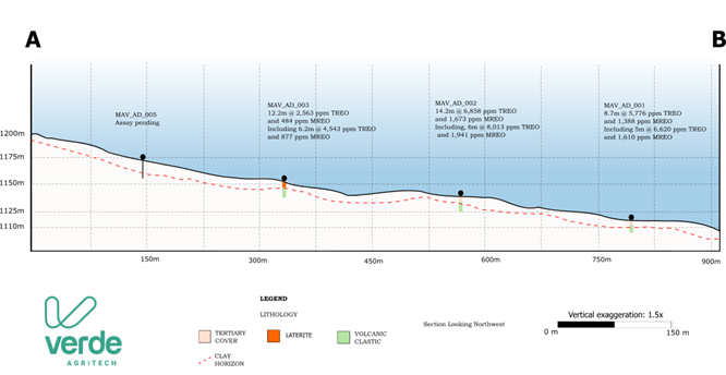
- Best intercept: 14.2 metres from surface averaging 6,858 ppm TREO and 1,673 ppm MREO, including 6.0 metres at 8,013 ppm TREO and 1,941 ppm MREO in hole MAV_AD 002
- High dysprosium content, with Dy₂O₃ up to 86 ppm in the best drill intercepts, strengthening the Project’s magnet rare earth profile
- Drill results confirm depth continuity of high‑grade mineralization below PT‑34 trench and materially increase confidence in expanding the broader mineralized footprint
- 200‑hole drill program underway to support a maiden NI 43‑101 mineral resource estimate targeted for Q1 2026
BELO HORIZONTE, Brazil, Dec. 02, 2025 (GLOBE NEWSWIRE) -- Verde AgriTech Ltd. (TSX: NPK | OTCQX: VNPKF) ("Verde” or the “Company”) is pleased to report assay results from the first three drill holes of its ongoing resource definition program at the Minas Americas Global Alliance rare earths project (the “Project”) in Minas Gerais, Brazil.
All three holes intersected continuous, clay‑hosted rare earth mineralization from surface, confirming the presence of high‑grade mineralized horizons and supporting the potential for significant expansion of the mineralized footprint (see news release dated October 21, 2025).
The current drill campaign, utilizing three rigs, commenced in October 2025 and is designed to test near‑surface clay‑hosted rare earth oxide (“REO”) mineralization. Key objectives are to:
- Extend mineralized zones identified in surface trenching through systematic step‑out and infill drilling around trench samples PT‑34, PT‑36, PT‑42 and other high‑priority surface anomalies;
- Test additional targets along interpreted mineralized trends; and
- Provide sufficient drill density in priority zones to support an initial NI 43‑101 mineral resource estimate (“MRE”) targeted for Q1 2026.
Exploration Highlights
- Continuous rare earth mineralization from surface in all three initial holes, hosted in highly weathered clay horizons typical of ionic adsorption clay (“IAC”) style deposits.
- High‑grade total rare earth oxides (“TREO”) and magnetic rare earth oxides (“MREO”) from shallow depths, including:
- MAV_AD 002
- 14.2 m from surface averaging 6,858 ppm TREO and 1,673 ppm MREO, with Nd₂O₃ 1,248 ppm, Pr₆O₁₁ 370 ppm, Dy₂O₃ 45 ppm and Tb₄O₇ 10 ppm;
- Including 6.0 m (4.0–10.0 m) at 8,013 ppm TREO and 1,941 ppm MREO, with Nd₂O₃ 1,241 ppm, Pr₆O₁₁ 355 ppm, Dy₂O₃ 53 ppm and Tb₄O₇ 10 ppm.
- MAV_AD 001 (approximately 10 m from trench PT‑34)
- 8.7 m from surface averaging 5,776 ppm TREO and 1,388 ppm MREO, with Nd₂O₃ 1,042 ppm, Pr₆O₁₁ 305 ppm, Dy₂O₃ 34 ppm and Tb₄O₇ 8 ppm;
- Including 5.0 m (0.0–5.0 m) at 6,620 ppm TREO and 1,610 ppm MREO, with Nd₂O₃ 1,206 ppm, Pr₆O₁₁ 355 ppm, Dy₂O₃ 39 ppm and Tb₄O₇ 9 ppm.
- MAV_AD 003
- 12.2 m from surface averaging 2,563 ppm TREO and 484 ppm MREO, with Nd₂O₃ 358 ppm, Pr₆O₁₁ 106 ppm, Dy₂O₃ 17 ppm and Tb₄O₇ 4 ppm;
- Including 6.2 m (6.0–12.2 m) at 4,543 ppm TREO and 877 ppm MREO, with Nd₂O₃ 650 ppm, Pr₆O₁₁ 190 ppm, Dy₂O₃ 30 ppm and Tb₄O₇ 6 ppm.
- The location of these first three holes, relative to previously reported PT‑34 trench results, materially increases confidence in the continuity and expansion potential of the mineralized footprint.
- The initial drill program is planned for approximately 200 drill holes by the end of February 2026, with the objective of defining a maiden MRE.
- All holes reported in this release intersected weathered, rare earth‑enriched clay horizons consistent with IAC‑style deposits.
“Our initial results from shallow drilling at the Minas Americas Global Alliance project validate our belief in the scale and quality of this rare earth discovery,” said Cristiano Veloso, Verde’s Founder and CEO. “All initial holes intersected continuous mineralization from surface, with strong contributions from high‑value magnet rare earths—neodymium, praseodymium, dysprosium and terbium. Combined with the excellent desorbable rare earth response previously reported, these results materially increase our confidence in expanding the mineralized footprint and rapidly advancing towards a maiden mineral resource estimate in Q1 2026.
“Verde is uniquely positioned to advance this project in parallel with our core sustainable fertilizer business. We have existing infrastructure, teams, and capital in the region, and we see a compelling opportunity to contribute to a secure, responsible supply of rare earths needed for the global energy transition,” Mr. Veloso added.
Initial Drill Results
Table 1: Results from initial drilling at Minas Americas Global Alliance exploration program
Assays reported as head grades in parts per million (“ppm”). MREO includes Nd, Pr, Dy and Tb oxides. TREO includes all rare earth oxides. All holes are vertical (90°). Based on current interpretation of a gently undulating mineralized horizon, the reported intervals are interpreted to represent true thickness.
| Hole ID | From | To | TREO (ppm) | MREO (ppm) | Nd₂O₃ (ppm) | Pr₆O₁₁ (ppm) | Dy₂O₃ (ppm) | Tb₄O₇ (ppm) |
| MAV_AD_001 | 0 | 8.7 | 5,776 | 1,388 | 1,042 | 305 | 34 | 8 |
| including | 0 | 5.0 | 6,620 | 1,610 | 1,206 | 355 | 39 | 9 |
| MAV_AD_002 | 0 | 14.2 | 6,858 | 1,673 | 1,248 | 370 | 45 | 10 |
| including | 4 | 10.0 | 8,013 | 1,941 | 1,241 | 355 | 53 | 10 |
| MAV_AD_003 | 0 | 12.2 | 2,563 | 484 | 358 | 106 | 17 | 4 |
| including | 6 | 12.2 | 4,543 | 877 | 650 | 190 | 30 | 6 |
| | | | | | | | | |
These results demonstrate continuous mineralization from surface across all three holes, with a strong contribution from high‑value magnet rare earths (Nd, Pr, Dy, Tb).
Figure 1: Project plan map showing significant intercepts from initial drilling
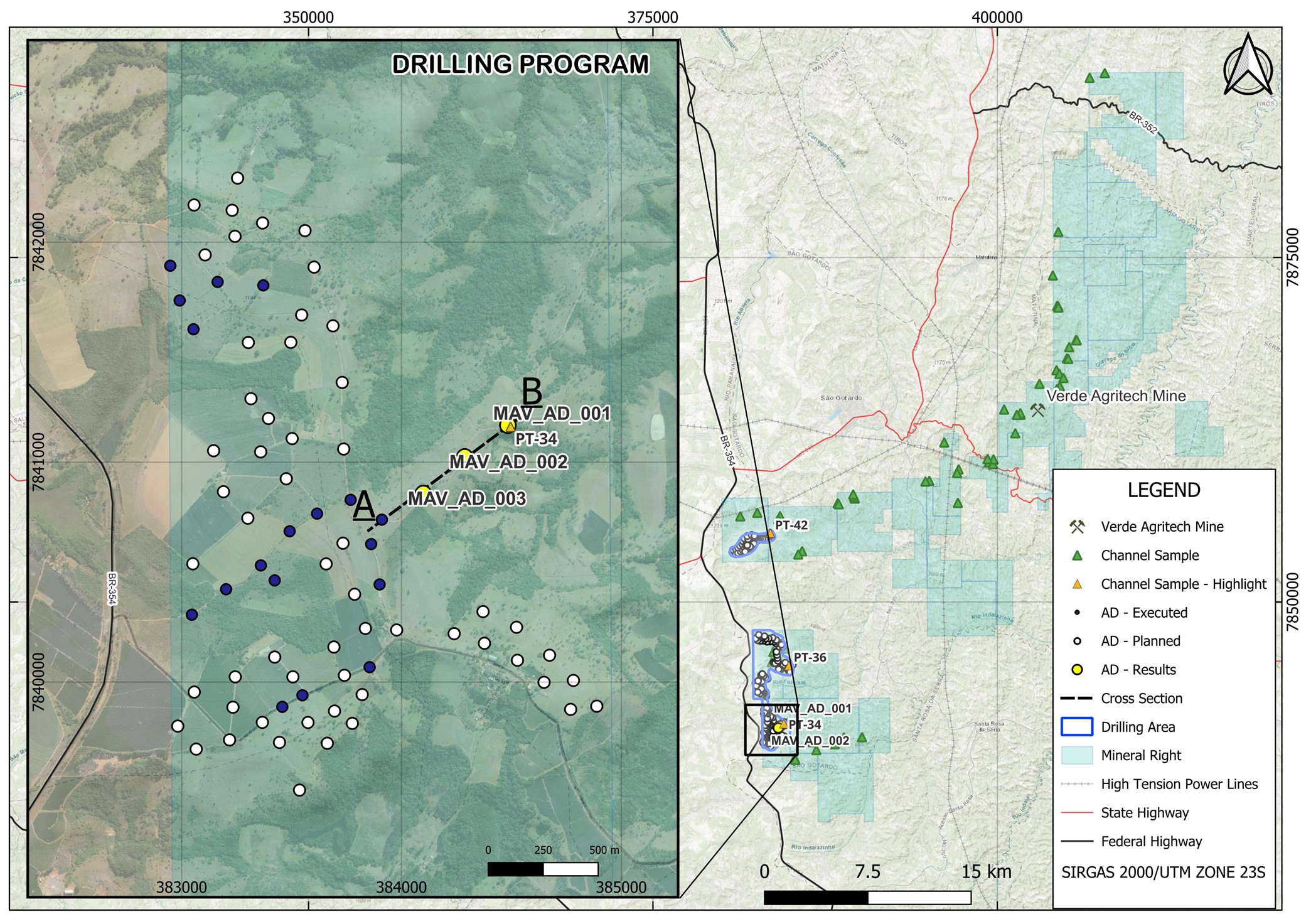
Figure 2: Cross section showing drill holes results
Initial Drilling Summary
The first three drill holes were completed in the priority PT‑34 target area. Key observations include:
- Consistent clay‑hosted mineralization from surface or near surface down‑hole in all holes;
- No significant groundwater issues, enabling efficient drilling and sampling;
- All holes were drilled vertically (90°); based on the current geological model of a gently undulating mineralized clay horizon, reported intervals are interpreted as true thickness;
- Samples were collected on 0.7 m to 1.2 m intervals and dispatched to SGS Geosol for major oxides (ICP‑OES) and complete rare earth element analysis (ICP‑MS).
PT‑34 Trench vs. Drilling: Depth Continuity of High‑Grade Mineralization
Trench sample PT‑34, previously reported (see news release dated October 21, 2025), returned excellent desorbable rare earth oxide (“DREO”) grades with exceptionally low impurities (uranium and thorium at or below detection limits), supporting an IAC‑style deposit model.
Vertical hole MAV_AD 001, collared approximately 10 m from PT‑34, was designed to test the down‑hole continuity of mineralization beneath the trench. Together with MAV_AD 002, the drill results demonstrate strong grade and thickness continuity below PT‑34.
Table 2: Comparison of Trench sample PT-34 and hole MAV_AD-002
| Parameter | PT-34 Trench (Surface) | MAV_AD-002
(Vertical Auger, 4-10m) | Comments |
| Average TREO (ppm) | 8,615 | 8,013 | Continuity confirmed between surface and depth |
| Average MREO (ppm) | 2,182 | 1,941 | Consistent magnetic REE fraction |
| Desorbable REO (DREO) | 578 mg/kg total, incl. ~240 mg/kg MREO | n/a (head grades reported) | Surface leachability supports IAC style model |
| Interval length (m) | Surface trench/channel | 6.0 m (4–10 m) | Deeper extension of mineralized zone confirmed |
The close spatial relationship and similar grade profiles between PT‑34 and holes MAV_AD 001 and MAV_AD 002 provide strong support for continuity of mineralization from surface to at least 8–10 m depth, reinforcing the resource expansion potential of this zone.
Metallurgical Program and Ionic Adsorption Clay Confirmation
Verde previously announced that leach tests on Project samples confirmed ionic‑adsorption clay behavior with high‑value magnet rare earths reporting strongly into solution and almost no contaminants. Using a mild 0.5M ammonium sulfate, 30‑minute leach, primary leach solutions returned up to:
- 667 mg/kg desorbable rare earth oxides (DREO); and
- ~278 mg/kg desorbable magnetic rare earth oxides (MREO: Nd, Pr, Dy, Tb),
with magnet REEs representing over 40% of dissolved rare earths. Impurities including thorium and uranium were at or below detection limits, and iron/aluminum were minimal, yielding a clean leachate well suited for downstream upgrading.
The strong DREO response at PT‑34 (578 mg/kg total DREO, ~240 mg/kg desorbable MREO, low U and Th) provides an encouraging foundation for the next phase of metallurgical work.
A dedicated metallurgical test program is being planned, including:
- Preparation of composite metallurgical samples from representative drill holes across key clay types and grade ranges;
- Ammonium salt leach tests and related characterization to evaluate DREO, optimize reagent conditions, and assess potential processing routes appropriate for clay‑hosted rare earth deposits; and
- More sophisticated, multi‑stage metallurgical test work to support a preliminary economic assessment (“PEA”).
Results of this metallurgical work will be reported as they become available and are interpreted.
Rare Earths Discovery and Launch of Resource Definition Drilling
In early October 2025, Verde reported the discovery of a continuous, clay‑hosted rare earth mineralized zone covering approximately 5,500 hectares across 13 mineral rights, delineated by integrated mapping, geochemistry, geophysics and trench sampling (see news release dated October 6, 2025). Highlight assays included:
- Up to 8,930 ppm TREO and up to 2,182 ppm MREO; and
- 75 trench/surface samples averaging 743 ppm MREO (54 of 75 samples ≥ 400 ppm; 22 of 75 samples ≥ 1,000 ppm).
Samples are NdPr‑rich (averaging ~19% of TREO, peaking at 24%) with high‑grade dysprosium and terbium—attributes aligned with magnet‑grade applications in electric vehicles, robotics and wind turbines.
Following this discovery, Verde initiated a three‑rig drilling program at the Project (see news release dated October 9, 2025), with the aim of quickly defining the highest‑quality resources and determining the fastest viable path to production.
Next Steps
Verde’s ability to advance the Project in an expedited and cost‑efficient manner is supported by:
- People: In‑house, multidisciplinary teams experienced in mapping, sampling and drilling, enabling a rapid field‑to‑decision cadence;
- Equipment: Company‑owned drill rigs, vehicles, field equipment and integrated IT systems for fast data capture;
- Laboratory: Verde’s laboratory supports sample preparation, scout assays and metallurgical screening in parallel with external labs, shortening cycles and de‑risking flowsheet choices;
- Execution Experience: In the same region, Verde has brought two mines into production and built two large‑scale industrial plants that are in operation today;
- Regional Infrastructure: Roads, bridges and high‑voltage power to site have been significantly upgraded by Verde, avoiding years of typical infrastructure lead time.
Key upcoming milestones at the Minas Americas Global Alliance project include:
- Q1 2026: Publication of a maiden NI 43‑101 mineral resource estimate;
- Q2 2026: Completion and publication of a PEA to demonstrate project economics.
Qualified Person
The scientific and technical information contained in this news release has been reviewed and approved by Leonardo Deringer Fraga, Vice‑President of Exploration, P.Geo, who is a Qualified Person as defined by National Instrument 43‑101 – Standards of Disclosure for Mineral Projects.
QAQC
Auger drillholes were completed vertically, and reported intervals are interpreted to represent true thickness. Material from auger drillholes was sampled at nominal one‑metre intervals, generating sample weights of approximately 5–25 kg per interval. Samples were split using a Jones riffle splitter to produce an analytical sub‑sample of approximately 1,000 g, with about 3 kg retained as backup material and the remaining material archived.
Bagged samples were shipped to SGS Geosol (Vespasiano, Minas Gerais, Brazil) for sample preparation and analysis. Rigorous procedures were implemented during sample collection, preparation, and analytical stages to help ensure the reliability and robustness of the results.
All analytical results reported herein have been subjected to internal QA/QC review prior to compilation. This news release presents exploration results only and does not constitute a mineral resource or mineral reserve estimate. Forward‑looking statements are subject to risks and uncertainties, and actual results may differ materially from those expressed or implied.
About Verde AgriTech
Verde AgriTech is dedicated to advancing sustainable agriculture through the innovation of specialty multi‑nutrient potassium fertilizers. The Company’s mission is to increase agricultural productivity, enhance soil health and contribute meaningfully to environmental sustainability.
Leveraging its unique position in Brazil, Verde uses proprietary technologies to develop solutions that address the immediate needs of farmers while tackling global challenges such as food security and climate change. Verde’s commitment to carbon capture and the production of eco‑friendly fertilizers underscores its vision for a future in which agriculture contributes positively to the health of the planet.
For more information, please visit: www.verde.ag and www.investor.verde.ag.
Cautionary Language and Forward-Looking Statements
This news release contains “forward‑looking information” within the meaning of applicable Canadian securities legislation, including, but not limited to, statements with respect to: the significance of exploration results; the potential for economic extraction of rare earth elements; future exploration and development plans; the outcome of the Board of Directors’ review; potential partnerships, strategic alternatives, or value‑maximizing structures; the advancement of the Project; and the expected timing of further updates. Forward‑looking information is based on management’s current expectations, assumptions, estimates, projections and interpretations and involves known and unknown risks, uncertainties and other factors that may cause actual results or events to differ materially from those expressed or implied.
These factors include, without limitation: risks related to exploration‑stage projects; the possibility that future exploration results may not support mineral resource or reserve delineation; uncertainties relating to assay and metallurgical results; operational risks inherent in mining; risks associated with maintaining licenses, permits and mineral rights; changes in laws, regulations and government policies; risks related to capital and operating costs; commodity price volatility; financing risks; and other risks described in the Company’s most recent annual information form and other continuous disclosure filings available under the Company’s profile at www.sedarplus.ca.
Readers are cautioned not to place undue reliance on forward‑looking information. The Company does not undertake to update or revise any forward‑looking statements, whether as a result of new information, future events or otherwise, except as required under applicable securities laws.
This news release reports exploration results which are preliminary in nature and do not represent mineral resources or mineral reserves as defined under NI 43‑101. There is no certainty that further exploration will result in the delineation of mineral resources or mineral reserves, or that any development decision will be made. Mineralization identified to date is not necessarily indicative of future results.
For additional information please contact:
Cristiano Veloso, Chief Executive Officer and Founder
Tel: +55 (31) 3245 0205; Email: investor@verde.ag
www.verde.ag | www.investor.verde.ag
Appendix
Table 3: Drill hole collar information
| Hole ID | Easting (UTM) | Northing
(UTM) | Elevation (m) | Depth
(m, EOH) | Dip | Date
Completed |
| MAV_AD 001 | 384,454 | 7,841,206 | 1,044 | 8.70 | 90° | Nov 15, 2025 |
| MAV_AD 002 | 383,282 | 7,841,027 | 1,149 | 14.20 | 90° | Nov 20, 2025 |
| MAV_AD 003 | 384,092 | 7,840,847 | 1,172 | 12.20 | 90° | Nov 25, 2025 |
*EOH = end of hole. Coordinates are reported in SIRGAS 2000/UTM ZONE 23S
Table 4: Full drilling results for holes MAV_AD_0001, MAV_AD_0002 and MAV_AD_0003
| Hole ID | From | To | Length | UTMN | UTME | CeO2 | Dy2O3 | Er2O3 | Eu2O3 | Gd2O3 | Ho2O3 | La2O3 | Lu2O3 | Nd2O3 | Pr6O11 | Sm2O3 | Tb4O7 | Tm2O3 | Y2O3 | Yb2O3 | TREO | MREO | %NdPr |
| MAV_AD_0001 | 0.0 | 1.0 | 1.0 | 384454 | 7841206 | 2968 | 34 | 9 | 33 | 77 | 4 | 1331 | 1 | 1039 | 299 | 139 | 8 | 1 | 104 | 5 | 6051 | 1380 | 22 | % |
| MAV_AD_0001 | 1.0 | 2.0 | 1.0 | 384454 | 7841206 | 3857 | 49 | 13 | 51 | 117 | 6 | 2042 | 1 | 1617 | 490 | 210 | 12 | 1 | 152 | 6 | 8623 | 2167 | 24 | % |
| MAV_AD_0001 | 2.0 | 3.0 | 1.0 | 384454 | 7841206 | 3132 | 44 | 13 | 42 | 101 | 6 | 1663 | 1 | 1299 | 394 | 172 | 10 | 1 | 170 | 7 | 7054 | 1747 | 24 | % |
| MAV_AD_0001 | 3.0 | 4.0 | 1.0 | 384454 | 7841206 | 2730 | 40 | 11 | 37 | 90 | 6 | 1326 | 1 | 1098 | 311 | 151 | 9 | 1 | 140 | 6 | 5956 | 1458 | 24 | % |
| MAV_AD_0001 | 4.0 | 5.0 | 1.0 | 384454 | 7841206 | 2580 | 31 | 8 | 32 | 73 | 4 | 1191 | 0 | 977 | 281 | 131 | 7 | 1 | 93 | 4 | 5411 | 1296 | 23 | % |
| MAV_AD_0001 | 5.0 | 6.0 | 1.0 | 384454 | 7841206 | 2455 | 29 | 7 | 30 | 69 | 4 | 1151 | 0 | 912 | 265 | 124 | 7 | 1 | 85 | 3 | 5143 | 1213 | 23 | % |
| MAV_AD_0001 | 6.0 | 7.0 | 1.0 | 384454 | 7841206 | 2341 | 30 | 9 | 29 | 70 | 4 | 1086 | 1 | 872 | 250 | 119 | 7 | 1 | 108 | 4 | 4932 | 1159 | 23 | % |
| MAV_AD_0001 | 7.0 | 8.0 | 1.0 | 384454 | 7841206 | 2347 | 29 | 8 | 28 | 66 | 4 | 1108 | 0 | 873 | 250 | 117 | 7 | 1 | 96 | 4 | 4938 | 1159 | 23 | % |
| MAV_AD_0001 | 8.0 | 8.7 | 0.7 | 384454 | 7841206 | 1828 | 23 | 6 | 22 | 52 | 3 | 880 | 0 | 690 | 199 | 92 | 5 | 1 | 75 | 3 | 3880 | 916 | 23 | % |
| MAV_AD_0002 | 0.0 | 1.0 | 1.0 | 384454 | 7841206 | 3484 | 43 | 12 | 44 | 103 | 6 | 1748 | 1 | 1381 | 417 | 184 | 10 | 1 | 129 | 6 | 7567 | 1851 | 24 | % |
| MAV_AD_0002 | 1.0 | 2.0 | 1.0 | 384282 | 7841027 | 3102 | 52 | 14 | 47 | 115 | 7 | 1751 | 1 | 1356 | 406 | 187 | 12 | 1 | 158 | 7 | 7217 | 1826 | 24 | % |
| MAV_AD_0002 | 2.0 | 3.0 | 1.0 | 384282 | 7841027 | 3181 | 58 | 15 | 52 | 130 | 8 | 1854 | 1 | 1491 | 446 | 209 | 13 | 2 | 173 | 8 | 7640 | 2008 | 25 | % |
| MAV_AD_0002 | 3.0 | 4.0 | 1.0 | 384282 | 7841027 | 2740 | 35 | 10 | 36 | 83 | 4 | 1351 | 1 | 1109 | 325 | 148 | 8 | 1 | 113 | 5 | 5969 | 1477 | 24 | % |
| MAV_AD_0002 | 4.0 | 5.0 | 1.0 | 384282 | 7841027 | 3055 | 39 | 11 | 39 | 91 | 5 | 1484 | 1 | 1210 | 353 | 164 | 9 | 1 | 131 | 6 | 6599 | 1611 | 24 | % |
| MAV_AD_0002 | 5.0 | 6.0 | 1.0 | 384282 | 7841027 | 3334 | 42 | 12 | 42 | 96 | 6 | 1642 | 1 | 1293 | 394 | 172 | 10 | 1 | 146 | 6 | 7196 | 1739 | 23 | % |
| MAV_AD_0002 | 6.0 | 7.0 | 1.0 | 384282 | 7841027 | 3716 | 43 | 12 | 44 | 101 | 6 | 1767 | 1 | 1403 | 430 | 184 | 10 | 1 | 145 | 6 | 7869 | 1886 | 23 | % |
| MAV_AD_0002 | 7.0 | 8.0 | 1.0 | 384282 | 7841027 | 4523 | 47 | 11 | 53 | 116 | 6 | 2128 | 1 | 1742 | 522 | 221 | 11 | 1 | 135 | 5 | 9520 | 2321 | 24 | % |
| MAV_AD_0002 | 8.0 | 9.0 | 1.0 | 384282 | 7841027 | 4241 | 59 | 17 | 58 | 136 | 8 | 2047 | 1 | 1720 | 513 | 234 | 14 | 2 | 204 | 9 | 9261 | 2305 | 24 | % |
| MAV_AD_0002 | 9.0 | 10.0 | 1.0 | 384282 | 7841027 | 3219 | 86 | 40 | 50 | 147 | 16 | 1546 | 4 | 1319 | 364 | 188 | 17 | 5 | 606 | 27 | 7632 | 1786 | 22 | % |
| MAV_AD_0002 | 10.0 | 11.0 | 1.0 | 384282 | 7841027 | 3105 | 54 | 23 | 42 | 110 | 9 | 1503 | 2 | 1229 | 361 | 167 | 11 | 3 | 353 | 14 | 6986 | 1656 | 23 | % |
| MAV_AD_0002 | 11.0 | 12.0 | 1.0 | 384282 | 7841027 | 2916 | 37 | 11 | 36 | 85 | 5 | 1367 | 1 | 1100 | 321 | 149 | 8 | 1 | 141 | 6 | 6183 | 1467 | 23 | % |
| MAV_AD_0002 | 12.0 | 13.0 | 1.0 | 384282 | 7841027 | 1712 | 21 | 6 | 20 | 49 | 3 | 817 | 0 | 637 | 183 | 85 | 5 | 1 | 78 | 3 | 3621 | 847 | 23 | % |
| MAV_AD_0002 | 13.0 | 14.2 | 1.2 | 384282 | 7841027 | 1308 | 16 | 4 | 16 | 36 | 2 | 625 | 0 | 484 | 141 | 65 | 4 | 0 | 53 | 3 | 2757 | 644 | 23 | % |
| MAV_AD_0003 | 0.0 | 1.0 | 1.0 | 384092 | 7840847 | 221 | 3 | 2 | 1 | 4 | 1 | 86 | 0 | 46 | 14 | 7 | 1 | 0 | 20 | 2 | 410 | 64 | 15 | % |
| MAV_AD_0003 | 1.0 | 2.0 | 1.0 | 384092 | 7840847 | 134 | 3 | 2 | 1 | 3 | 1 | 74 | 0 | 24 | 9 | 3 | 0 | 0 | 21 | 3 | 279 | 37 | 12 | % |
| MAV_AD_0003 | 2.0 | 3.0 | 1.0 | 384092 | 7840847 | 163 | 5 | 3 | 1 | 5 | 1 | 87 | 1 | 43 | 14 | 6 | 1 | 1 | 28 | 4 | 361 | 62 | 16 | % |
| MAV_AD_0003 | 3.0 | 4.0 | 1.0 | 384092 | 7840847 | 200 | 3 | 2 | 1 | 3 | 0 | 93 | 0 | 38 | 13 | 5 | 0 | 0 | 16 | 2 | 377 | 54 | 13 | % |
| MAV_AD_0003 | 4.0 | 5.0 | 1.0 | 384092 | 7840847 | 443 | 4 | 2 | 2 | 6 | 1 | 235 | 0 | 75 | 26 | 9 | 1 | 0 | 22 | 2 | 829 | 106 | 12 | % |
| MAV_AD_0003 | 5.0 | 6.0 | 1.0 | 384092 | 7840847 | 638 | 7 | 3 | 5 | 12 | 1 | 304 | 0 | 164 | 52 | 22 | 1 | 0 | 26 | 3 | 1239 | 225 | 17 | % |
| MAV_AD_0003 | 6.0 | 7.0 | 1.0 | 384092 | 7840847 | 1898 | 23 | 11 | 15 | 37 | 4 | 903 | 1 | 439 | 136 | 64 | 5 | 1 | 93 | 11 | 3640 | 603 | 16 | % |
| MAV_AD_0003 | 7.0 | 8.0 | 1.0 | 384092 | 7840847 | 2108 | 21 | 11 | 11 | 30 | 4 | 582 | 1 | 295 | 92 | 43 | 4 | 2 | 101 | 10 | 3314 | 411 | 12 | % |
| MAV_AD_0003 | 8.0 | 9.0 | 1.0 | 384092 | 7840847 | 2588 | 18 | 6 | 14 | 33 | 3 | 555 | 1 | 400 | 120 | 58 | 4 | 1 | 62 | 5 | 3864 | 541 | 13 | % |
| MAV_AD_0003 | 9.0 | 10.0 | 1.0 | 384092 | 7840847 | 3498 | 36 | 10 | 34 | 78 | 5 | 1214 | 1 | 1043 | 303 | 152 | 8 | 1 | 105 | 6 | 6494 | 1390 | 21 | % |
| MAV_AD_0003 | 10.0 | 11.0 | 1.0 | 384092 | 7840847 | 2381 | 41 | 14 | 32 | 82 | 6 | 1247 | 1 | 912 | 263 | 131 | 9 | 1 | 147 | 9 | 5276 | 1225 | 22 | % |
| MAV_AD_0003 | 11.0 | 12.2 | 1.2 | 384092 | 7840847 | 2132 | 42 | 14 | 30 | 80 | 6 | 1035 | 1 | 811 | 227 | 121 | 9 | 2 | 150 | 10 | 4671 | 1089 | 22 | % |
Photos accompanying this announcement are available at:
https://www.globenewswire.com/NewsRoom/AttachmentNg/b480b69d-73c0-474f-82a6-33e8e68293df
https://www.globenewswire.com/NewsRoom/AttachmentNg/5e85c62e-38cf-4448-89ce-bc03e2cc91a0


Project plan map showing significant intercepts from initial drilling
Project plan map showing significant intercepts from initial drilling
Cross section showing drill holes results
Cross section showing drill holes results
© 2026 Canjex Publishing Ltd. All rights reserved.