Highlights:
- Regional drilling approved: Visionary has received approval for exploration drilling across the broader Pt. Leamington land package, valid until November 9, 2028.
- Stockley and French claims cleared for drilling: The approval covers the recently acquired Stockley claims and the French claims, which together host five airborne electromagnetic ("EM") conductors on the horizon that hosts the Pt. Leamington deposit, two of them with historical massive sulphide boulders reported nearby.
- Lewis Lake consolidated: Visionary has staked a 300-hectare mineral licence in the core of the ground explored from 1999 to 2001 by Rubicon Minerals under option to Billiton Exploration Canada Ltd. (now BHP).
- Historical drilling ended in mineralization: Historical hole LL2000-13 returned 49.8 m of 0.12% Cu from 13.2 m, and alteration and sulphide mineralization continued to the end of the hole at 424.3 m. The associated induced polarization ("IP") chargeability anomaly extends for at least 2 km and was tested by only three holes.
- Gold with zinc at surface and in drill core: Historical grab samples returned 1% to 3% Zn with up to 1.2 g/t Au and 38 g/t Ag, and historical hole LL2000-07 returned 1.60 m of 1.42 g/t Au, including 0.60 m of 3.04 g/t Au.
- Soil anomaly not drill tested: A 2008 soil survey outlined a 0.6 km² gold-copper-lead-zinc-silver anomaly centred on the historical drilling at Nanny Bag Lake, and it has never been drill tested.
Vancouver, British Columbia--(Newsfile Corp. - November 17, 2026) - Visionary Copper and Gold Mines Inc. (TSXV: VCG) (OTCQB: VCGMF) (the "Company" or "Visionary") is pleased to announce that it has received exploration approval from the Newfoundland and Labrador Department of Energy and Mines for diamond drilling across the broader land package at its 100%-owned Pt. Leamington Project (the "Project") in central Newfoundland. The approval authorizes up to 25 ground-supported diamond drill holes and is valid until November 9, 2028. It covers the recently acquired Stockley claims and the French claims (which the Company has agreed to acquire) south of the Pt. Leamington Deposit, and the Lewis Lake area to the east (Figure 1).
The Company has also staked an additional mineral licence of 12 claims (300 hectares) to consolidate its position in the Lewis Lake area (Figure 2). Lewis Lake was explored from 1999 to 2001 by Billiton Exploration Canada Ltd. ("Billiton", now BHP) under an option agreement. The newly staked licence is surrounded by the Company's existing licences and covers ground with historical drilling, surface sampling and geophysical surveys that the Company considers prospective for volcanogenic massive sulphide ("VMS") mineralization.
Max Porterfield, President and CEO of Visionary, stated, "Noranda found the Pt. Leamington Deposit by drilling an airborne conductor with massive sulphide boulders nearby, and we now hold the permits to test conductors with that same signature on the Stockley and French claims. At Lewis Lake, the ground we have just staked sits in the heart of the area Billiton explored, where historical holes ended in sulphide mineralization and a large chargeability anomaly remains largely untested."
Jason Flight, Visionary's Vice President of Exploration, commented, "The Nanny Bag Lake area shows features we look for in the footwall of a VMS system: a large zone of pyritic alteration associated with zinc and gold at surface, and anomalous copper and zinc in drill core over long intervals. Rubicon and Billiton drilled three holes into a chargeability anomaly that extends for at least two kilometres, and a later soil survey outlined a multi-element anomaly over the same ground that, to our knowledge, was never drilled. With the area consolidated, we can evaluate it together with the untested off-hole conductors at JEN and Fall Pond West as a single system."
Regional Drill Approval
The exploration approval was issued on November 9, 2026 under the Mineral Act (Newfoundland and Labrador). It is separate from the Phase 2 drilling approval for the Pt. Leamington Deposit announced on September 1, 2026. The newly approved drilling areas include:
- Southern trend: ground south of the Pt. Leamington Deposit along the host horizon, including the newly acquired Stockley and French claims; and
- Lewis Lake: target areas east of the Deposit that were explored by BHP, including the JEN, Fall Pond West and Northern Bog grids.
Southern Trend: Airborne Conductors with Massive Sulphide Boulders
A 2007 HeliGEOTEM airborne EM survey identified five isolated conductors on the Pt. Leamington host horizon along approximately 3 km of trend south of the Deposit. Historically massive sulphide boulders have been reported near two of the conductors. These include a boulder of predominantly massive pyrite with quartz veining, sampled by Noranda Exploration Company Limited ("Noranda"), that returned 0.43% Cu, 0.23 g/t Au and 5.8 g/t Ag (see news releases dated September 22, 2026 and October 22, 2026).
This is the same combination that led to the discovery of the Pt. Leamington Deposit. In the 1970s, Noranda identified an airborne EM anomaly, found massive sulphide boulders near the conductor, and intersected massive sulphide in the first hole drilled to test it.
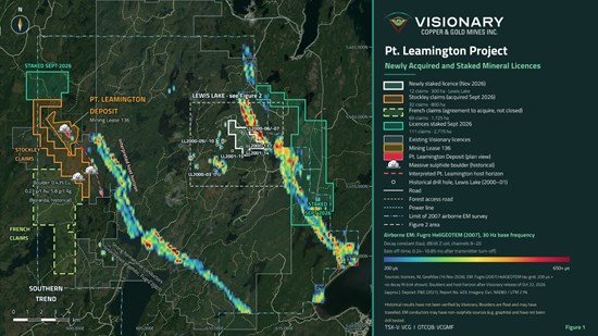
Figure 1: Pt. Leamington Project — newly acquired and staked mineral licences with 2007 airborne EM.
To view an enhanced version of this graphic, please visit:
https://images.newsfilecorp.com/files/3408/324454_a251459cd42dfa83_001full.jpg
Lewis Lake: Consolidating Ground Explored by Billiton (now BHP)
The Lewis Lake area lies approximately 8 km east of the Pt. Leamington Deposit and covers a large felsic volcanic-intrusive complex of the Wild Bight Group centred on Nanny Bag Lake. The Wild Bight Group is the host stratigraphy of the Pt. Leamington Deposit. Visionary staked the majority of the area earlier this year (see news release dated May 21, 2026). The newly staked licence comprises 12 claims (300 hectares) in the Fall Pond - Nanny Bag Lake area and is surrounded by the Company's existing licences.
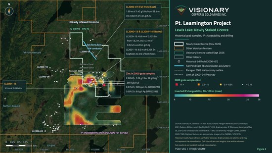
Figure 2: Lewis Lake — newly staked licence with historical grab samples, IP chargeability and drilling.
To view an enhanced version of this graphic, please visit:
https://images.newsfilecorp.com/files/3408/324454_a251459cd42dfa83_002full.jpg
Historical Exploration
Between 1999 and 2001, Rubicon and Billiton explored Lewis Lake for a large felsic volcanic-associated VMS deposit. Their work included:
- a 1,100 line-km Geoterrex airborne EM and magnetic survey that identified 15 conductors or conductive areas;
- approximately 75 km of line cutting on seven grids, with 74 km of ground transient EM ("TEM") and 72.5 km of magnetic and VLF-EM surveys;
- 22.4 km of pole-dipole IP surveys on the Nanny and JEN-Nanny Extension grids; and
- 15 diamond drill holes totalling 2,822 m, with borehole EM surveys on selected holes.
Rubicon concluded that the drilling had "established an environment that is permissive to host a large massive sulphide deposit" and recommended further drilling and ground follow-up. No further drilling was completed. Subsequently, in 2008 Paragon Minerals Corporation ("Paragon") completed an 863-sample soil survey over the Nanny Bag Lake area.
Nanny Bag Lake: A Large Sulphide-Bearing Alteration System
Mapping has outlined an extensive zone of pyritic alteration, approximately 1.0 km by 0.5 km, in felsic volcanic rocks and quartz porphyry on the north side of Nanny Bag Lake (the "Big Asco Pond" area). In 2000, zinc mineralization was discovered in two areas 450 m apart within this zone, with grab samples returning 1% to 3% Zn, up to 1.2 g/t Au and up to 38 g/t Ag.
An IP survey then outlined a large chargeability anomaly with a strike extent of at least 2 km. It lies on the western edge of a large circular magnetic high centred on Nanny Bag Lake. Three holes tested a limited part of the anomaly and notably LL2000-13 intersected intensely altered quartz porphyry carrying 3% to 10% sulphides (pyrite, pyrrhotite, chalcopyrite and sphalerite) as fractures, stringers and disseminations from surface to 308 m. It returned 49.8 m of 0.12% Cu from 13.2 m, including 4.3 m of 0.34% Cu and 6.4 g/t Ag (424.3 m). Individual samples returned up to 0.99% Cu over 0.70 m.
Rubicon reported that alteration and mineralization persisted to the end of both LL2000-13 and LL2001-14. It also noted that only the western part of the magnetic high had been covered, and that the area had been overlooked in the past because it lacks EM conductors. Previous operators also observed that the zinc-rich portion of the Pt. Leamington Deposit is itself only weakly conductive to non-conductive.
Paragon's 2008 soil survey outlined a multi-element anomaly of approximately 0.6 km² centred on holes LL2000-13 and LL2001-14, with values up to 784 ppb Au, 188 ppm Cu, 290 ppm Pb, 430 ppm Zn and 3.2 ppm Ag. Paragon recommended prospecting, mapping and diamond drilling over the anomaly; however, no drilling followed.
Fall Pond East: An Unexplained Conductor with Gold
The Fall Pond East grid covers a 700 m long ground TEM conductor with a highly conductive core, interpreted to lie near the eastern contact of the Nanny Bag quartz porphyry. Two holes drilled 200 m apart, LL2000-06 and LL2000-07, did not explain the conductor because dykes occupy its projected position. Both holes were blocked and could not be surveyed with borehole EM.
Notably, LL2000-07 returned 1.60 m of 1.42 g/t Au from 58.4 m, including 0.60 m of 3.04 g/t Au.
Table 1: Selected Historical Drill Results, Fall Pond East and Nanny Grids
| Hole | Grid | From (m) | To (m) | Length (m) | Au (g/t) | Ag (g/t) | Cu (%) | Zn (%) |
| LL2000-07 | Fall Pond East | 58.40 | 60.00 | 1.60 | 1.42 | 0.48 | 0.01 | <0.01 |
| includes |
| 58.40 | 59.00 | 0.60 | 3.04 | 0.82 | 0.02 | <0.01 |
| LL2000-13 | Nanny | 13.20 | 63.00 | 49.80 | 0.02 | 1.90 | 0.12 | <0.01 |
| includes |
| 31.70 | 35.25 | 3.55 | <0.01 | 0.70 | 0.02 | 0.25 |
| includes |
| 42.20 | 46.50 | 4.30 | 0.02 | 6.40 | 0.34 | <0.01 |
Source: 2001 Rubicon-Billiton Assessment Report, Table III. Intervals are core lengths; true widths are unknown. Assays by Eastern Analytical Ltd., Springdale, Newfoundland.
Exploration Opportunities
With the Fall Pond - Nanny Bag Lake area consolidated, Visionary sees the following opportunities:
- Nanny Bag Lake IP and soil anomaly: a chargeability anomaly at least 2 km long with a coincident multi-element soil anomaly, tested by three holes that all intersected sulphide mineralization, with the remainder of the magnetic high not yet covered by IP;
- Fall Pond East conductor: a 700 m long conductor that remains unexplained, with gold in hole LL2000-07;
- Gold: elevated gold in surface samples on the Nanny grid, in soils and in drill core at Fall Pond East and Fall Pond West, which has not been systematically assessed; and
- Adjacent drill-permitted targets: the strong off-hole EM conductors at the JEN grid (LL2000-03) and Fall Pond West grid (LL2000-09 and LL2000-10) and the undrilled 20-channel conductor at Northern Bog, all recommended for drilling by BHP/Rubicon and now covered by the Company's exploration approval (see news release dated May 21, 2026).
Next Steps
Visionary's technical team is compiling the historical Lewis Lake drilling, geochemistry and geophysics into the Project's 3D model, together with the Company's 2026 prospecting and soil sampling over the Lewis Lake target areas. The Company will use this work to rank regional drill targets on the southern trend and at Lewis Lake alongside its Phase 2 program at the Pt. Leamington Deposit.
The newly staked licence was recorded after the exploration approval application was submitted and is not included in the approval. The Company intends to apply to add it before any drilling on that licence.
Historical Information
The historical drilling, sampling and geophysical results described in this news release were generated by previous operators and have not been independently verified by Visionary. The historical drill core was sawn, with half submitted for analysis. Samples were analyzed by Eastern Analytical Ltd., Springdale, Newfoundland, with check assays by ALS Chemex, North Vancouver, British Columbia. Other quality control procedures used by previous operators are unknown. Grab samples are selective by nature and may not represent the mineralization on the property. Soil results indicate the presence of metals in overburden and do not establish bedrock mineralization. The Company considers the historical information relevant for exploration targeting but is not treating it as current verified exploration results.
Historical information for the Lewis Lake area is sourced from assessment reports filed with the Government of Newfoundland and Labrador:
- 2001 Rubicon-Billiton Assessment Report: Assessment Report on the Lewis Lake Project, Licenses 5435M, 6915M, 7206M: Report on Diamond Drilling and Downhole Geophysical Surveys, by J. Garfield MacVeigh, Rubicon Minerals Corporation, dated April 17, 2001 (Geofile 002E/1205); and
- 2009 Paragon Assessment Report: Assessment Report on Soil Sampling on the Lewis Lake Property, Licence 5435M (11th year), by Dan Downton, Paragon Minerals Corporation, dated January 27, 2009.
Qualified Person
The technical information contained in this news release has been reviewed and approved by Jason Flight, P.Geo., a "qualified person" under NI 43-101. Mr. Flight is not independent under NI 43-101 as he is Vice President of Exploration for the Company. Historical information was reviewed against available assessment reports filed with the government by previous operators. This review did not include independent verification of the underlying historical data.
About Visionary Copper and Gold Mines Inc.
Visionary Copper and Gold Mines Inc. (TSXV: VCG) (OTCQB: VCGMF) is advancing its portfolio of base and precious metals rich deposits located in established Canadian mining jurisdictions. The focus of the portfolio is highlighted by the 100%-owned Pt. Leamington Deposit in Newfoundland, located in one of the richest VMS and Gold Districts in Canada. The Company prepared a pit constrained Indicated Mineral Resource of 5.0 Mt grading 1.42% CuEq for 156.8 Mlb CuEq (145.7 koz gold, 60.0 Mlb copper, 153.5 Mlb zinc, 2.0 Moz silver, 1.5 Mlb lead), a pit constrained Inferred Mineral Resource of 13.7 Mt grading 1.27% CuEq for 384.8 Mlb CuEq (354.8 koz gold, 110.2 Mlb copper, 527.3 Mlb zinc, 6.2 Moz silver, 7.0 Mlb lead) and an out-of-pit Inferred Mineral Resource of 1.7 Mt grading 1.74% CuEq for 65.7 Mlb CuEq (65.4 koz gold, 13.3 Mlb copper, 102.9 Mlb zinc, 1.4 Moz Ag, 2.6 Mlb lead) (see news release dated October 25, 2021). Additionally, the Company is permitting the Rainbow deposit at its rich VMS Pine Bay Project located near existing infrastructure in the Flin Flon Mining District. The Company prepared an indicated mineral resource on the Rainbow deposit of 3.44 Mt grading 3.59% CuEq for 272.4 Mlb CuEq (238.3 Mlb Cu, 56.9 Mlb Zn, 37.6 koz Au, 692.8 koz Ag, 2.3 Mlb Pb), an inferred mineral resource on the Rainbow deposit of 1.28 Mt grading 2.95% CuEq containing 83.4 Mlb CuEq (72.1 Mlb Cu, 19.5 Mlb Zn, 11.1 koz Au, 222.2 koz Ag, 0.8 Mlb Pb) and an inferred mineral resource at the Pine Bay deposit of 1.0 Mt grading 2.62% Cu containing 58.1 Mlb Cu (see news release dated July 10, 2023). The Company is also advancing the 100%-owned Kismet Copper-Zinc Project in the Saskatchewan portion of the Flin Flon Greenstone Belt as part of its hub-and-spoke strategy in the Flin Flon Mining District. Additionally, the portfolio includes the Nash Creek Project located in the VMS rich Bathurst Mining District of New Brunswick. A 2018 PEA generates a strong economic return with a pre-tax IRR of 34.1% (25.2% post-tax) and NPV8% of $230 million ($128 million post-tax) at $1.25 Zinc (see news release dated May 14, 2018).
Neither the TSX Venture Exchange nor its Regulation Services Provider (as that term is defined in the policies of the TSX Venture Exchange) accepts responsibility for the adequacy or accuracy of this release.
Some statements in this news release contain forward-looking information. These statements include, but are not limited to, statements with respect to future expenditures, the Company's plans for regional exploration and drilling at the Pt. Leamington Project, the timing and scope of future drilling, the closing of the French claims acquisition, the receipt of any additional permits, approvals or amendments required for that work, the prospectivity of the targets described herein and the potential for the Stockley and French claims and the Lewis Lake area to host mineralization. These statements address future events and conditions and, as such, involve known and unknown risks, uncertainties and other factors which may cause the actual results, performance or achievements to be materially different from any future results, performance or achievements expressed or implied by the statements. Such factors include, among others, the ability to complete the proposed drill programs, receipt of all necessary permits and approvals, availability of qualified personnel and equipment, results of exploration activities, the accuracy of historical data, additional capital requirements, the timing and amount of expenditures, and general market and economic conditions. The reader is cautioned that historical exploration results, geophysical interpretations and conceptual targets discussed herein are not indicative of the presence of an economic mineral deposit. Except as required under applicable securities laws, Visionary does not assume the obligation to update any forward-looking statement.

To view the source version of this press release, please visit https://www.newsfilecorp.com/release/324454

© 2026 Canjex Publishing Ltd. All rights reserved.