Toronto, Ontario--(Newsfile Corp. - September 17, 2026) - GT Resources Inc. (TSXV: GT) (OTCQB: CGTRF) (FSE: 7N1) (the "Company" or "GT") is pleased to announce results of the first MobileMT ("Mobile MagnetoTellurics") survey on the CD Copper-Gold Project in Yukon's Dawson Range Gold Belt, located near Carmacks (the "Property" or "CD") (Figure 1). CD hosts a gold-copper porphyry target with co-incident soil and geophysical anomalies, and valid drill permits until 2033.
"The MobileMT survey identified a 'blind', concentric body, which may represent a buried porphyry intrusion located directly south of a coincident strong gold-in-soil and Induced Polarization ("IP") chargeability anomaly (Figure 1, 2 & 3). This combined with new geological mapping leads us to believe that a multi-intrusive centre is present at the Maloney Porphyry Target, similar to Forge Resources Corp's Alotta project (Figure 4). Additionally, the MobileMT survey identified an area of low resistivity coincident with the IP chargeability anomaly, thereby providing additional conviction in our target by de-risking with multiple exploration tools.
MobileMT was specifically chosen for its ability to help map disseminated sulphides, alteration, and geological contacts. While IP is excellent at identifying near surface features, MobileMT is geared toward greater depths, and combining the two has allowed GT to create a detailed 3D model of the Maloney porphyry target and refine drill targets.
In simple terms, these results mean we have isolated a high-priority, drill-ready target that shares many similarities with major regional deposits. This allows us to target our upcoming drilling with higher precision and lower geological risk," commented Neil Pettigrew, Vice President of Exploration.
The CD Project exhibits compelling geological parallels to Western Copper and Gold's Casino porphyry deposit, situated 90 kilometers to the northwest (Figure 1). The Casino deposit hosts a Measured and Indicated Resource Estimate of 2.39 billion tonnes containing 7.6 billion pounds of copper and 14.8 Moz of gold (Roth et al. 2022 ).
Geophysical Program Highlights
Maloney Target:
Potential Buried Porphyry System:
Multi-Intrusive Porphyry System:
Correlation between MobileMT an IP anomalies
The MobileMT survey identified a zone of low resistivity (i.e. conductivity) on the northern flank of the resistive body, which coincides with the IP chargeability anomaly, a strong gold-in-soil anomaly, and overlapping zones of strong brecciation and phyllic alteration on surface, building confidence in the MobileMT system. These targets remain untested by drilling.
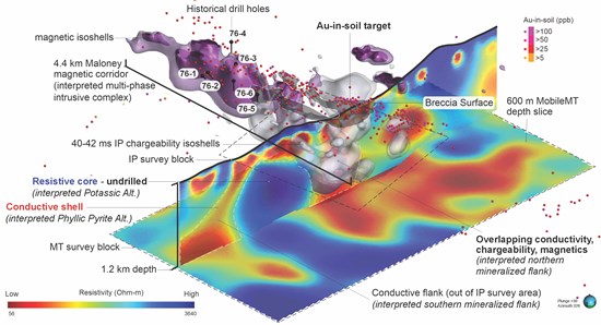
Figure 1. 3D isometric view (looking northwest) of CD's Maloney porphyry target (the Maloney target) showing a MobileMT cross section and a resistivity depth slice at 600 m below surface. The depth slice highlights a discrete body ("resistive core") interpreted as a buried, potassic-altered porphyry intrusion, located directly south of the coincident gold-in-soil and IP chargeability anomaly. Isoshells show a magnetic-high core (purple) flanked by an IP chargeability high rim (grey). This pattern is interpreted to be a magnetite-bearing porphyry dykes and associated alteration (epidote-pyrite-magnetic & actinote-magnetite-quartz+/-biotite) plunging to the southeast. surrounded by strong phyllic (sericite-quartz-pyrite) alteration halo, and brecciation and veining similar to the breccia-hosted mineralization which surrounds a porphyry intrusion (the Patton porphyry) at the Casino deposit. These dykes and associated alteration may represent the upper levels of the porphyry system with the larger intrusive located at depth to the south, as illustrated in Figure 2. The MobileMT survey consisted of 30 lines at 100 m line spacing covering an area of approximately 5.5 x 2.9 km. 2D inversions of the data were resolved to approximately 1.1 km depth. Note: Geophysical anomalies are interpretations of 2D inversion products, untested by drilling, and are not direct evidence of mineralization.
To view an enhanced version of this graphic, please visit:
https://images.newsfilecorp.com/files/6502/314675_5b41e84264e20ac4_001full.jpg
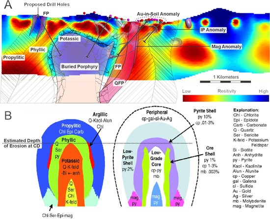
Figure 2, A. MobileMT cross section showing interpreted alteration halos, buried porphyry intrusive and dykes FP - (Feldspar Porphyry), QFP - (Quartz Feldspar Porphyry) with IP chargeability and Magnetic isoshells as well as gold-in-soil anomalies. Proposed drill holes are shown in Black; B. The classical porphyry model (from Safari et. al. 2017, modified from Lowell & Guilbert 1970) showing a cross section of hydrothermal alteration mineral zones (left) and ores associated with each alteration zone (right)
To view an enhanced version of this graphic, please visit:
https://images.newsfilecorp.com/files/6502/314675_5b41e84264e20ac4_002full.jpg
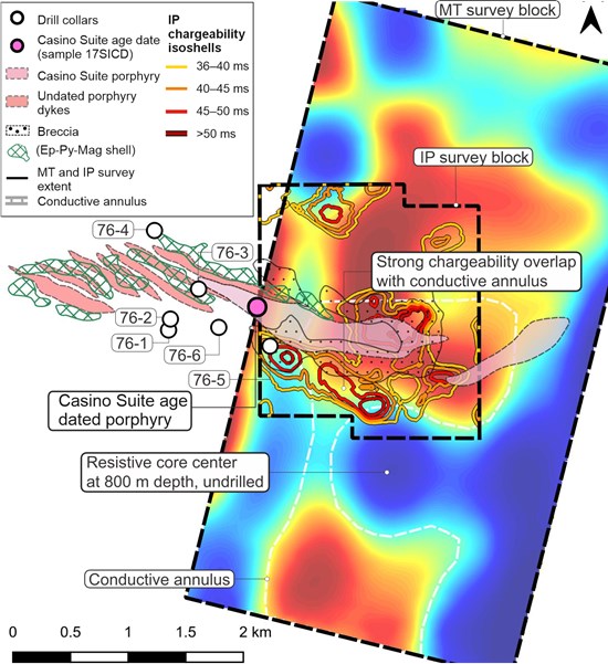
Figure 3. Plan map (900m depth slice) of the Maloney porphyry target showing Porphyry intrusive dykes, alteration halos and breccia with outlines of the IP survey and recent MobileMT survey highlighting the circular resistive core, interpreted to be a buried porphyry intrusive and correlation of MobileMT low resistivity and IP chargeability anomalies.
To view an enhanced version of this graphic, please visit:
https://images.newsfilecorp.com/files/6502/314675_5b41e84264e20ac4_003full.jpg
Exploration Plan and Next Steps
2026
GT's inaugural work program has refined the Maloney porphyry targets and reduced reliance on widely spaced, expensive, and higher risk conceptual drill testing, supporting a more efficient allocation of exploration capital.
Mineralogical studies to further refine porphyry style alteration halos and age dating of prospective porphyry intrusive rocks are planned prior to drill testing.
2027
GT's plans to conduct a 2,500 to 3,000 meter diamond drill program (Figure 4) at the beginning of the exploration season. This campaign has been designed to systematically test the gold-rich copper porphyry potential and high-grade gold-silver vein targets.
Geology of the CD Project
The CD Project lies within the Yukon-Tanana terrane (Figure 4), a continental arc that developed along the ancient Pacific margin of North America from the Late Devonian to Permian and is situated between the Tintina Fault to the northeast, and the Denali Fault to the southwest. In the CD Project vicinity, specifically the Maloney Target area, the terrane is dominated by the Devonian and older rocks of the Snowcap Assemblage, consisting of fine clastic rocks, quartzite, psammite and conglomerate, including marble horizons metamorphosed to amphibolite grade. The Snowcap Assemblage has been intruded by numerous intermediate to felsic granitoid batholiths since the early Jurassic, notably in the Casino and CD areas by the voluminous mid-Cretaceous Whitehorse Suite. The Whitehorse Suite intrusive event (~112-105 million years) was followed by a more restricted late Cretaceous Casino / Prospector Mountain Suite (~79-65 million years) felsic intrusive event with U-Pb dating of CD's Maloney stock to ~75.0 Ma which correlates to the Casino suite (74.2 ± 0.7 Ma) (Joyce et al., 2020, GSC OF 8614). Both late Cretaceous intrusive suites are associated with mineralization at other porphyry related deposits, including Casino, Alotta, Freegold, Klaza, and Mount Nansen (Figure 4). Structurally, these deposits are located near the intersection of large-scale northwest and smaller scale northeast structures which may provide dilation for late Cretaceous porphyry intrusions and/or hydrothermal vein formation (Figure 4).
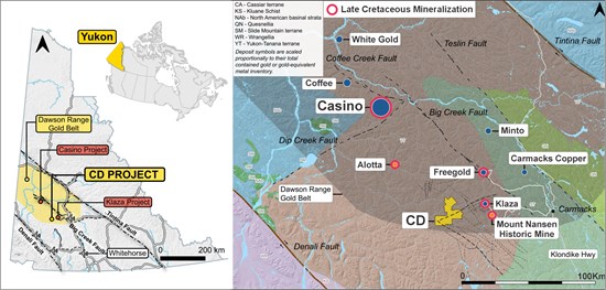
Figure 4. (A) Location map of the CD project and nearby projects within the Dawson Range Gold Belt. (B) Regional geology surrounding the CD project, including location of nearby deposits (blue) and exploration projects (orange), notably those of similar late Cretaceous age "Casino & Prospector Mountain Suite" including Casino, Alotta, Freegold, Klaza and Mount Nansen.
To view an enhanced version of this graphic, please visit:
https://images.newsfilecorp.com/files/6502/314675_5b41e84264e20ac4_004full.jpg
References
Lowell JD, Guilbert JM. 1970. Lateral and vertical alteration-mineralization zoning in porphyry ore deposits. Econ Geol. 65:373-408.
Sillitoe, R.H., 2010. Porphyry copper systems. Economic Geology 105:3-41
Morteza Safari, Abbas Maghsoudi & Amin Beiranvand Pour (2017): Application of Landsat-8 and ASTER satellite remote sensing data for porphyry copper exploration: a case study from Shahr-e-Babak, Kerman, south of Iran, Geocarto International, DOI: 10.1080/10106049.2017.1334834
Paulter, J., 2018. Technical Report on the CD Project in the Dawson Range Copper - Gold belt, Yukon territory for Strategic Metals Ltd.
Joyce, N.L., Iraheta Muniz, P., Rayner, N.M. and Ryan, J.J., 2020. Geochronology of the Mount Nansen-Nisling River area, Yukon; Geological Survey of Canada, Open File 8614
Roth, D., Hester, M., Marek, J.M., Tahija, L.M., Schulze, C., Friedman, D., Weston, S., 2022. Casino Project Form 43-101F1 Technical Report, Feasibility Study, Yukon, Canada.
Qualified Person
The technical information in this release has been reviewed and approved by Neil Pettigrew, M.Sc., P.Geo., Vice President of Exploration and a Director of the Company and the Qualified Person as defined by National Instrument 43-101.
About GT Resources
GT Resources Inc. (TSXV: GT) (OTCQB: CGTRF) (FSE: 7N1) is a mineral exploration company focused on the discovery and de-risking of district-scale assets in top tier mining jurisdictions. The Company's strategy is driven by a disciplined, science-based methodology designed to create shareholder value by advancing high-potential properties toward production within robust regulatory frameworks.
In Finland, the Company is advancing its flagship Läntinen Koillismaa ("LK") Project, which hosts significant mineral resources including palladium, platinum, gold, copper, and nickel. In Canada, GT maintains a portfolio of earlier-stage, pre-resource projects targeting critical and precious metals. The quality and scale of the Company's project portfolio has attracted strategic investment from Glencore plc, one of the world's largest diversified natural resource companies.
Follow GT Resources on LinkedIn, X, and at https://gtresourcesinc.com/.
ON BEHALF OF THE BOARD
"Derrick Weyrauch"
President & CEO, Director
Neither the TSX Venture Exchange nor its Market Regulator (as that term is defined in the policies of the TSX Venture Exchange) accepts responsibility for the adequacy or accuracy of this release.
This press release is not an offer or a solicitation of an offer of securities for sale in the United States of America. The common shares of GT Resources Inc. have not been and will not be registered under the U.S. Securities Act of 1933, as amended, and may not be offered or sold in the United States absent registration or an applicable exemption from registration.
Information set forth in this press release may contain forward-looking statements. Forward-looking statements are statements that relate to future, not past events. In this context, forward-looking statements often address a company's expected future business and financial performance, and often contain words such as "anticipate", "believe", "plan", "estimate", "expect", and "intend", statements that an action or event "may", "might", "could", "should", or "will" be taken or occur, or other similar expressions. By their nature, forward-looking statements involve known and unknown risks, uncertainties and other factors which may cause our actual results, performance or achievements, or other future events, to be materially different from any future results, performance or achievements expressed or implied by such forward-looking statements. Such factors include, among others, risks associated with project development; the need for additional financing; operational risks associated with mining and mineral processing; fluctuations in mineral and commodity prices; title matters; environmental liability claims and insurance; reliance on key personnel; the absence of dividends; competition; dilution; the volatility of our common share price and volume; and the impact of governmental entities. Forward-looking statements are made based on management's beliefs, estimates and opinions on the date that statements are made and the Company undertakes no obligation to update forward-looking statements if these beliefs, estimates and opinions or other circumstances should change. Investors are cautioned against attributing undue certainty to forward-looking statements.
Mineralization at Casino is not necessarily indicative of mineralization at the CD project.

To view the source version of this press release, please visit https://www.newsfilecorp.com/release/314675

© 2026 Canjex Publishing Ltd. All rights reserved.