Vancouver, British Columbia--(Newsfile Corp. - February 11, 2026) - Gold Finder Resources Ltd. (TSXV: GLD) (OTCQB: GLDFF) ("Gold Finder" or the "Company") is pleased to announce the results of the latest field program on Block A of its 100%-owned West Madsen property ("the Property") that is situated in the heart of the Red Lake Gold Camp.
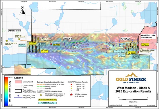
Figure 1: West Madsen 2025 soil sampling and prospecting results.
To view an enhanced version of this graphic, please visit:
https://images.newsfilecorp.com/files/7436/283436_e33fd40104fdc9e2_001full.jpg
Emerald Geological Services completed a prospecting and soil sampling program in the fall, targeting two areas near the western and eastern property boundaries, which were previously explored during the summer (see Gold Finder's news release of Sep. 9, 2025). A total of 45 grab samples and 194 "A" horizon soil samples were collected during the program. Six infill soil sampling lines were completed in Area 1 in the western part of the Property, and four southern extension soil sampling lines were completed in Area 2 in the eastern part of the Property. Prospecting was then carried out at several targets across the Property. Results for the soil sampling and prospecting programs are presented below.
Fall Soil Sampling Program
Area 1 covers an area from Tack Lake, where the Balmer-Confederation contact has been identified in drilling, to the western property boundary with Athena Gold's ("Athena") Laird Lake property, where Athena previously reported a bonanza-grade grab sample of 373 g/t Au (see Athena's news release of Dec. 4, 2024) and the identification of new gold-in-till anomalies (see Athena's news release of Sep. 4, 2025). During Gold Finder's fall program, six north-south lines of "A" horizon soil sampling were completed as infill lines to the summer survey, each 500 meters long and spaced 100 meters apart with 25-meter sample station spacing. These were designed to test the southern half of the survey area from the summer, where anomalies of 228 ppb Au and 109 ppb Au were obtained (see Sept 9th news release, linked above). The two highest anomalies obtained from the most recent sampling were 51 ppb Au and 39 ppb Au, both located along the same east-west trend as the 228 ppb Au anomaly, north of an east-west linear magnetic high (see Figure 2 and Table 1).
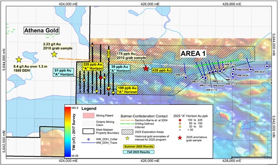
Figure 2: West Madsen - Area 1.
To view an enhanced version of this graphic, please visit:
https://images.newsfilecorp.com/files/7436/283436_e33fd40104fdc9e2_002full.jpg
Area 2 covers an area near the eastern Property boundary, where 2020 soil sampling yielded anomalies up to 106 ppb Au from "A" horizon, and where 2024 drillholes WM-24-03 and WM-24-04 intersected ultramafic flows believed to belong to the Balmer Assemblage, which hosts the current and past producing gold mines of the Red Lake Camp (see Gold Finder's news release of Nov. 7, 2024). During the fall program, four north-south lines of "A" horizon soil sampling were completed as southern extensions of the summer survey lines, which had yielded two anomalies of 76 ppb Au close to the southern extreme of the summer survey (see Sept 9th news release, linked above). The highest value obtained from the most recent sampling was 37 ppb Au near the south end of the extension lines (see Figure 3 and Table 1).
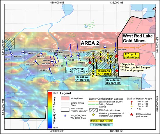
Figure 3: West Madsen - Area 2.
To view an enhanced version of this graphic, please visit:
https://images.newsfilecorp.com/files/7436/283436_e33fd40104fdc9e2_003full.jpg
| Table 1 | Oct 2025 Top "A" Horizon Sample Results |
| Sample | Area | Datum_Grid | Easting | Northing | Elev (m) | Au ppb (INAA) |
| C278376 | Area 1 (West) | NAD83 UTM Z15 | 424349 | 5643459 | 423 | 51 |
| C278432 | Area 1 (West) | NAD83 UTM Z15 | 424848 | 5643508 | 435 | 39 |
| C278489 | Area 2 (East) | NAD83 UTM Z15 | 431176 | 5643100 | 439 | 37 |
Table 1: Top "A" horizon soil sampling results from the fall field program
Fall Prospecting Program
Prospecting was carried out at several target areas across the Property during the fall program. No significant gold anomalies were obtained from the 45 grab samples collected. However, one sample (C270024) returned 0.19% chromium (Cr) and 0.10% nickel (Ni) from an altered ultramafic outcrop in the eastern part of the Property, proximal to one of the 76 ppb Au soil sample anomalies from the summer program. Another sample (C270043) returned 386 ppm molybdenum (Mo) from mafic outcrop with quartz veining in the eastern part of the Property (See Figure 3 and Table 2). It is unknown whether Mo may be a pathfinder for Au mineralization in this area.
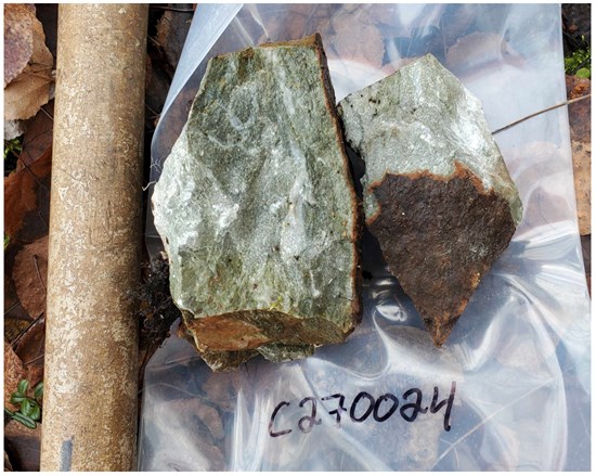
Sample C270024 - Altered ultramafic rock, 0.19% Cr, 0.10% Ni
To view an enhanced version of this graphic, please visit:
https://images.newsfilecorp.com/files/7436/283436_dc0f96b22478b9b8_001full.jpg
| Table 2 | Oct 2025 Notable Grab Sample Results |
| Sample | Area | Easting | Northing | Elev (m) | Datum | Rock Type | Source | Description | Notable Results |
| C270024 | Block A East | 431061 | 5643440 | 443 | NAD83 UTM Z15 | Ultramafic | Outcrop | Altered ultramafic with minor quartz stringers. | 0.19% Cr, 0.10% Ni |
| C270043 | Block A East | 431963 | 5643167 | 424 | NAD83 UTM Z15 | Mafic volcanic | Outcrop | Mafic volcanic with minor to moderate rusty quartz veinlets. | 386 ppm Mo |
Table 2: Notable rock results from fall 2025 field program
Ultramafic / peridotite sills and flows with komatiitic geochemistry are common within the Balmer assemblage, commonly altered to serpentine and magnetite or tremolite-actinolite. The distribution of gold on the adjoining Madsen Mine property is almost exclusively within altered basalt but is enhanced proximal to major lithological contacts, such as ultramafic sills, iron formations, felsic dykes and felsic volcanic strata (please refer to the technical report entitled "NI 43-101 Technical Report and Prefeasibility Study for the Madsen Mine, Ontario, Canada", prepared by SRK Consulting (Canada) Inc. with an effective date of January 7, 2025). In future exploration programs, it will be important to conduct detailed geological mapping to identify areas where the Balmer basaltic rocks are in contact with ultramafic sills and other units that help focus gold mineralization. Prospecting, reconnaissance field mapping, and diamond drilling on the Property strongly suggest that the Balmer-Confederation contact must be located further south than previously thought in Area 2 (e.g. as portrayed by Sanborn-Barrie et al. 2004; see Figure 3).
"The 2025 field programs concentrated on both the western and eastern boundaries of the Property, aiming to trace major structural and mineralized corridors that extend from neighbouring claims onto our ground," said Greg Lytle, President of Gold Finder. "We have confirmed significant gold mineralization in the central part of Block A, east of Tack Lake, as well as beneath Tack Lake itself. Our 2025 initiatives successfully uncovered new gold anomalies at the Property's extremities and identified key rock units, which will guide our drill target development work in 2026. Moving forward, our priority will be systematic geological mapping to integrate these findings and correlate our rock units with the geology of the Madsen Mine. This approach should enable us to target drillholes more precisely."
QAQC
Soil and rock samples were collected, documented, and photographed in the field, then placed in sealed bags and delivered to Activation Laboratories (ActLabs) in Thunder Bay, an ISO/IEC 17025-accredited laboratory. Soil sample collection is subject to Emerald Geological Services' internal quality assurance / quality control (QAQC) protocols, which include the insertion of blank material and certified reference material into each batch of samples submitted. Rock samples referenced in this news release were analyzed using ActLabs methods 1A2-50, a 50g fire assay with atomic absorption finish, and 1F2, a total digestion with ICP-OES finish for trace elements. "A" horizon soil samples were analyzed using ActLabs methods 2A, an INAA analysis for gold and trace elements, as well as ActLabs method 2C1, an aqua regia partial digestion with ICP finish for select metals.
About the West Madsen Gold Project
The West Madsen Gold Project covers 5,988 hectares in the heart of the Red Lake Gold Camp. It is comprised of two contiguous claim blocks: Block A to the east and Block B to the west, both accessible by secondary roads connecting to Ontario HWY 618, then to the town of Red Lake, 15 km to the northeast. Block A adjoins the Madsen Gold mine property, owned by West Red Lake Gold Mines, which declared commercial production on January 12, 2026 (see WRLG's news release of Jan. 12, 2026).
The bulk of the mineral resources on the Madsen mine property are hosted in a ~7-km-long gold trend that follows the major crustal break or contact between the Balmer and Confederation assemblages. Gold Finder has observed the same Balmer-Confederation contact in outcrop approximately 1.5 km west of the eastern claim boundary and identified it within an ~8-km corridor of disrupted regional magnetics that traverses Block A from the Madsen mine property.
Gold Finder's exploration work, focused on Block A, has included geophysical interpretations, regional mapping and prospecting, rock sampling, a soil-gas-hydrocarbon SGH survey, and approximately 11,100 metres of diamond drilling over 28 holes.
Diamond drilling has identified gold anomalies in both Balmer and Confederation Assemblage rocks. 2020 drilling intersected 14.4 g/t Au over 0.5 meters in strongly altered Balmer mafic volcanic rocks (hole WM-20-05, see news release of Jul. 22, 2020), and 2021 drilling intersected 0.16 g/t Au over 195 m, including 0.51 g/t Au over 10.90 m from felsic intrusive rocks of the Confederation Assemblage (hole WM-21-22, see news release of Jun. 1, 2021). Follow-up drilling to the latter intersection in 2024, 100 meters along strike to the southwest, intersected 0.28 g/t Au over 15 meters from the felsic intrusive rocks and 0.85 g/t Au over 9.44 meters from silicified metasediments in the hanging wall to the felsic intrusive rocks (hole WM-24-05, see news release of Nov. 7, 2024).
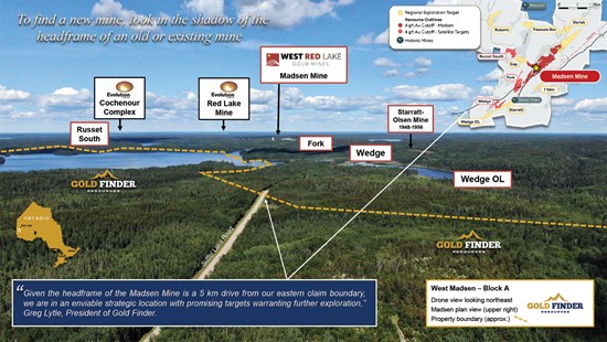
Figure 4: Drone view looking NE toward WRLG's Madsen Gold Mine/Mill Complex.
To view an enhanced version of this graphic, please visit:
https://images.newsfilecorp.com/files/7436/283436_e33fd40104fdc9e2_005full.jpg
The technical information in this news release was reviewed and approved by Coleman Robertson, B.Sc., P. Geo., a qualified person (QP) for the purposes of NI 43-101 and V.P. Exploration for Emerald Geological Services.
References
Sanborn-Barrie, M., Skulski, T., and Parker, J., 2004. Geology, Red Lake greenstone belt, Western Superior Province, Ontario; Geological Survey of Canada, Open File 4594, scale 1:50,000.
About Gold Finder Resources Ltd.
Gold Finder is a mineral exploration company focused on discovery-stage properties. Our goal is to add value by defining or redefining the exploration opportunity, maintain ownership control during the value creation phase of discovery, and then source a well-financed partner capable of accelerating discovery, resource definition, and development. Management continues to evaluate new exploration opportunities that could further enhance the Company's growth profile and add shareholder value. For more information, you can visit our website at goldfinderresources.com, download our investor presentation, and follow us on X at https://x.com/GoldFinderRes.
Forward-Looking Statements
This news release may contain "forward-looking statements" that involve known and unknown risks, uncertainties, assumptions, and other factors that may cause the actual results, performance, or achievements of the Company to be materially different from any future results, performance or achievements expressed or implied by the forward-looking statements. Any forward-looking statement speaks only as of the date of this news release and, except as may be required by applicable securities laws, the Company disclaims any intent or obligation to update any forward-looking statement, whether as a result of new information, future events, or results or otherwise.
Neither TSX Venture Exchange nor its Regulation Services Provider (as that term is defined in the policies of the TSX Venture Exchange) accept responsibility for the adequacy or accuracy of this release.
To view the source version of this press release, please visit https://www.newsfilecorp.com/release/283436

© 2026 Canjex Publishing Ltd. All rights reserved.