VANCOUVER, British Columbia, Feb. 16, 2021 (GLOBE NEWSWIRE) -- Sonoro Gold Corp. (TSXV: SGO | OTCQB: SMOFF | FRA: 23SP) (“Sonoro” or the “Company”) is pleased to report the latest assay results from its ongoing drilling program at the Company’s Cerro Caliche gold project in Sonora, Mexico. The new results reflect 24 drill holes, totaling 2,591 meters and highlight the following:
- Significant increase of strike length at the Buena Suerte gold mineralized zone to 900 meters.
- High-grade intercepts at the newly identified southern extension at Buena Suerte including SCR-159 which intercepted 3.05 meters averaging 6.839 g/t Au.
- Continuous mineralization confirmed at the two kilometers long El Rincón - Veta de Oro - Abejas vein and stockwork gold mineralized zone.
- Identification of the new Bellotoso gold mineralized zone with an initial strike length of 1.2 kilometers.
A Media Snippet accompanying this announcement is available by clicking on the image or link below:
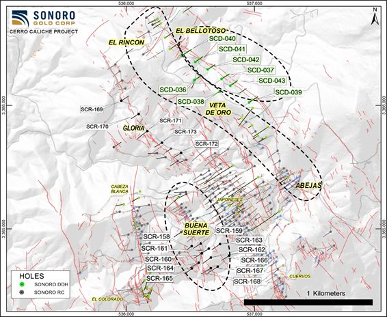
Map of Cerro Caliche Drill Holes Being Reported
Kenneth MacLeod, President & CEO of Sonoro, commented: “Our strategy of infill and expansion drilling in our defined gold mineralized zones, together with strategically located scout holes in prospective new zones, is proving to be very successful. The addition of Bellotoso to our inventory of mineralized zones and the prospect of additional zones in parallel with Bellotoso, suggests that the mostly unexplored northeast region of Cerro Caliche may develop into a very significant exploration target.”
John Darch, Chairman of Sonoro, also noted: “The continued material expansion of the Buena Suerte Gold Zone and the positive drilling results at El Rincón and the newly identified Bellotoso zone not only brings us closer to our goal of developing a major bulk-tonnage, oxide gold resource to support both the conceptual 20,000 tonnes per day target capacity being addressed by our planned preliminary economic assessment, but also the potential for gold production growth in the years to come.”
Buena Suerte Zone Extended to the South and Southeast
At Buena Suerte, results extend the zone to a total length of approximately 900 meters, suggesting a material contribution to Cerro Caliche’s growing inventory of drilling-defined potentially bulk mineable oxide gold mineralization. Drilling extended the vein zone to the southeast by approximately 300 meters along strike, with additional south-trending vein structures expanding the cross-section of the zone approximately 300 meters in the southern extension. Assay highlights include:
- SCR-159 intercepted 7.62 m averaging 3.088 g/t Au, including 3.05 m averaging 6.839 g/t Au.
- SCR-158 intercepted 6.10 m averaging 0.731 g/t Au, including 3.05 m averaging 1.354 g/t Au.
- SCR-160 intercepted 6.10 m averaging 0.785 g/t Au, and 1.53 m averaging 1.769 g/t Au.
- SCR-167 intercepted 3.05 m averaging 2.325 g/t Au, and 3.05 m averaging 0.787 g/t Au.
Drill hole SCR-159 is located approximately 60 meters southeast of the previously reported SCR-143 which intercepted 12.19 meters averaging 0.687 g/t Au, including 1.52 meters averaging 1.741 g/t Au. Approximately 100 meters to the west of the main Buena Suerte vein structure, drill hole SCR-158 targeted a separate parallel vein zone. Drill hole SCR-164 extends the parallel running vein approximately 120 meters to the southeast to nearly intersect the main zone where drill hole SCR-168 cut several intercepts with gold mineralization, including 3.05 meters averaging 0.798 g/t Au, and 6.09 meters averaging 0.462 g/t Au.
Buena Suerte Assay Results
| Cerro Caliche Project, holes composites with cutoff 0.15 Au g/t |
Hole
| Target
|
| From | To | Interval | Au | Ag | AuEq |
| meters | g/t | g/t | g/t |
SCR-158
| BUENA SUERTE
| | 53.34 | 59.44 | 6.10 | 0.731 | 18.2 | 0.992 |
| includes | 56.39 | 59.44 | 3.05 | 1.354 | 26.7 | 1.735 |
| and | 62.48 | 67.06 | 4.58 | 0.304 | 6.1 | 0.393 |
| and | 86.87 | 89.92 | 3.05 | 0.538 | 0.3 | 0.543 |
SCR-159
| BUENA SUERTE
| | 19.81 | 27.43 | 7.62 | 3.088 | 7.3 | 3.192 |
| includes | 19.81 | 22.86 | 3.05 | 6.839 | 10.5 | 6.989 |
| and | 30.48 | 33.53 | 3.05 | 0.981 | 6.0 | 1.067 |
| includes | 32.00 | 33.53 | 1.53 | 1.608 | 9.7 | 1.747 |
| SCR-160 | BUENA SUERTE | | 0.00 | 4.57 | 4.57 | 0.754 | 0.9 | 0.767 |
| includes | 1.52 | 3.05 | 1.53 | 1.769 | 1.4 | 1.789 |
| and | 9.14 | 16.76 | 7.62 | 0.202 | 0.9 | 0.215 |
| and | 19.81 | 25.91 | 6.10 | 0.785 | 1.0 | 0.799 |
| Cerro Caliche Project, holes composites with cutoff 0.15 Au g/t |
Hole
| Target | | From | To | Interval | Au | Ag | AuEq |
| | meters | g/t | g/t | g/t |
SCR-161
| BUENA SUERTE
| | 35.05 | 38.10 | 3.05 | 0.403 | 0.3 | 0.408 |
| and | 74.68 | 77.72 | 3.04 | 1.150 | 1.2 | 1.167 |
| includes | 74.68 | 76.20 | 1.52 | 2.110 | 1.5 | 2.131 |
| and | 91.44 | 94.49 | 3.05 | 0.571 | 2.1 | 0.602 |
SCR-162
| BUENA SUERTE | | 50.29 | 53.34 | 3.05 | 0.214 | 2.2 | 0.245 |
| | and | 73.15 | 76.20 | 3.05 | 0.235 | 1.0 | 0.249 |
| SCR-163 | BUENA SUERTE | | 25.91 | 27.43 | 1.52 | 0.333 | 0.2 | 0.335 |
SCR-164
| BUENA SUERTE
| | 0.00 | 12.19 | 12.19 | 0.260 | 2.5 | 0.296 |
| and | 15.24 | 33.53 | 18.29 | 0.240 | 7.9 | 0.353 |
| and | 57.91 | 60.96 | 3.05 | 0.481 | 1.6 | 0.503 |
| and | 67.06 | 70.10 | 3.04 | 0.204 | 2.8 | 0.244 |
| and | 83.82 | 86.87 | 3.05 | 0.206 | 9.0 | 0.334 |
SCR-165
| BUENA SUERTE
| | 0.00 | 3.05 | 3.05 | 0.263 | 1.9 | 0.290 |
| and | 6.10 | 10.67 | 4.57 | 0.360 | 1.4 | 0.380 |
| and | 38.10 | 41.15 | 3.05 | 0.765 | 0.7 | 0.776 |
| SCR-166 | BUENA SUERTE | | 39.62 | 41.15 | 1.53 | 0.756 | 0.3 | 0.760 |
SCR-167
| BUENA SUERTE
| | 65.53 | 68.58 | 3.05 | 0.787 | 0.5 | 0.794 |
| and | 103.63 | 106.68 | 3.05 | 2.325 | 1.7 | 2.348 |
SCR-168
| BUENA SUERTE
| | 12.19 | 15.24 | 3.05 | 0.798 | 3.3 | 0.846 |
| and | 51.82 | 56.39 | 4.57 | 0.492 | 0.5 | 0.499 |
| and | 64.01 | 70.10 | 6.09 | 0.462 | 0.8 | 0.473 |
Continuous Mineralization at El Rincón - Veta de Oro - Abejas Zone
Between El Rincón and Veta de Oro, infill drill holes SCD-036 and SCD-037 intersected narrow gold mineralized intervals confirming a one-kilometer-long gold mineralized zone connecting the 250-meter-long El Rincón zone with the 500-meter-long Veta de Oro vein system. The zone extends further southeast to the 300-meter-long Abejas stockwork zone and may extend another 500 meters southeast to include the Chinos Altos historic mine area. Future drilling will investigate this untested area.
El Rincón remains open along strike to the northwest following outcropping quartz veins and infill drilling focused on linear zones of disseminated-stockwork and higher-grade gold bearing veins along El Rincón’s southeastern striking trend beginning 100 meters southeast of SCD-021. As earlier reported in a news release dated December 8, 2020, SCD-021 intercepted 21 meters averaging 0.88 g/t Au including 2.9 meters averaging 3.86 g/t Au. The area is covered in soil and is steeply sloping, making the exact identification of the vein system challenging.
New Bellotoso Gold Mineralized Vein-Stockwork Zone
The newly discovered Bellotoso zone is located parallel to the east side of the El Rincón - Veta de Oro mineralized zone and follows a similar northwest trend. Six core drill holes completed in this zone identify a range of very encouraging gold mineralized widths, including SCD-043 which intercepted 3 meters averaging 1.67 g/t AuEq. In the zone’s southeast, drill hole SCD-039 intercepted 2.2 meters averaging 2.227 g/t AuEq and 300 meters to the northwest, SCD-037 intercepted 2 meters averaging 1.78 g/t AuEq. Located approximately 200 meters to the northwest along strike, drill hole SCD-041 returned several intervals of gold mineralization, including 3.5 meters averaging 0.985 g/t AuEq.
The Bellotoso mineralized trend currently has a length of approximately 1.2 kilometers and scattered rock samples and historic soil samples from earlier exploration indicate mineralization may continue southeast to the Espanola vein zone. If confirmed, Bellotoso’s shallow, mineralized, oxide gold zone may extend another 1.5 kilometers. The Company plans to investigate this potential with drilling planned at the Espanola vein zone.
Drilling results from Bellotoso are part of a wider anomalous gold mineralized zone than identified in the reported intervals. For example, the three intervals reported in SCD-043 are within a broader 48.8-meter zone of anomalous gold mineralization averaging 0.372 g/t Au. Bellotoso has demonstrated wider zones containing higher-grade gold intercepts over its 1.2-kilometer length and geological indications suggest that it may merge with the Espanola vein zone into one potentially bulk mineable zone with a combined length of 2.7 kilometers. The Company is currently investigating Bellotoso’s potential as an additional source in the Cerro Caliche’s inventory of shallow oxide gold mineralization.
Mel Herdrick, Sonoro’s VP of Exploration, commented: “Thereported intervals show that where new zones are being drill tested, they demonstrate positive results with significant intervals of gold mineralization. We are currently drilling to define the 500-meter-long west side of Japoneses ridge and also drilling up to an additional 19 holes at Buena Suerte to increase the mineralization definition before we resume drilling in the Rincon and Bellotoso, areas in March.”
El Rincón - Veta de Oro and Bellotoso Assay Results
| Cerro Caliche Project, holes composites with cutoff 0.15 Au g/t |
Hole
| Target
|
| From | To | Interval | Au | Ag | AuEq |
| meters | g/t | g/t | g/t |
| SCD-036 | VETA DE ORO | | 89.00 | 90.00 | 1.00 | 0.536 | 4.1 | 0.595 |
SCD-037
| EL BELLOTOSO
| | 39.20 | 43.25 | 4.05 | 0.333 | 7.8 | 0.444 |
| and | 52.00 | 61.00 | 9.00 | 0.215 | 2.1 | 0.244 |
| and | 74.10 | 80.10 | 6.00 | 0.286 | 1.3 | 0.305 |
| and | 96.00 | 98.00 | 2.00 | 1.384 | 28.4 | 1.789 |
| includes | 96.00 | 97.00 | 1.00 | 2.601 | 47.6 | 3.281 |
| SCD-038 | VETA DE ORO | | 51.40 | 55.10 | 3.70 | 0.431 | 33.5 | 0.909 |
SCD-039
| EL BELLOTOSO
| | 14.10 | 16.30 | 2.20 | 1.661 | 39.6 | 2.227 |
| includes | 15.10 | 16.30 | 1.20 | 2.800 | 59.9 | 3.656 |
| and | 40.00 | 44.90 | 4.90 | 0.407 | 2.6 | 0.444 |
SCD-040
| EL BELLOTOSO
| | 25.80 | 36.15 | 10.35 | 0.300 | 0.5 | 0.307 |
| and | 114.00 | 127.15 | 13.15 | 0.249 | 1.1 | 0.265 |
SCD-041
| EL BELLOTOSO
| | 37.50 | 46.50 | 9.00 | 0.310 | 10.1 | 0.453 |
| and | 52.40 | 53.30 | 0.90 | 1.418 | 20.5 | 1.711 |
| and | 61.30 | 64.80 | 3.50 | 0.776 | 14.6 | 0.985 |
| includes | 62.30 | 63.30 | 1.00 | 1.362 | 29.5 | 1.783 |
SCD-042
| EL BELLOTOSO
| | 22.00 | 24.40 | 2.40 | 0.615 | 43.1 | 1.230 |
| and | 58.20 | 63.10 | 4.90 | 0.239 | 1.1 | 0.255 |
SCD-043
| EL BELLOTOSO
| | 13.90 | 16.90 | 3.00 | 1.454 | 11.5 | 1.617 |
| and | 24.60 | 38.70 | 14.10 | 0.390 | 3.6 | 0.441 |
| and | 46.90 | 62.70 | 15.80 | 0.383 | 2.2 | 0.414 |
Gloria Zone
The Gloria vein trend, located over one kilometer northwest of the Japoneses zone, was drill tested with holes SCR-169 through SCR-173. These five drill holes cut the targeted vein zone, with only SCR-10 containing a reportable interval of 12.19 meters averaging 0.331 g/t Au or 0.408 g/t AuEq. The remaining holes contained only minor intervals with low gold content without any significant gold bearing zones. Drilling by Sonoro during 2018 demonstrated multiple lower-grade intercepts in four drill holes along trend northwest of the current drilling, with the most notable being SCR-053 which reported 1.52 meters grading 0.676 g/t Au (see Sonoro news release dated April 29, 2019). The Gloria zone will be further assessed to determine the prospect for additional drilling along trend to the northwest.
Drill collar locations, azimuths and dips for the drill holes included in this release are provided in the table below.
| Drill Collar Locations (NAD 1927 UTM Zone 12N) |
| Drill Hole | Zone | Easting | Northing | Elevation | Depth (m) | Dip | Azimuth |
| SCR-158 | Buena Suerte | 536511 | 3364860 | 1359 | 100.58 | -45 | 235 |
| SCR-159 | Buena Suerte | 536581 | 3364881 | 1328 | 100.58 | -45 | 235 |
| SCR-160 | Buena Suerte | 536589 | 3364802 | 1312 | 100.58 | -45 | 235 |
| SCR-161 | Buena Suerte | 536644 | 3364840 | 1318 | 106.68 | -45 | 235 |
| SCR-162 | Buena Suerte | 536661 | 3364768 | 1328 | 115.82 | -45 | 235 |
| SCR-163 | Buena Suerte | 536732 | 3364877 | 1349 | 112.78 | -45 | 235 |
| SCR-164 | El Quínce | 536565 | 3364727 | 1294 | 109.73 | -45 | 235 |
| SCR-165 | El Quínce | 536512 | 3364679 | 1280 | 100.58 | -45 | 235 |
| SCR-166 | Buena Suerte | 536803 | 3364783 | 1285 | 100.58 | -45 | 235 |
| SCR-167 | Buena Suerte | 536714 | 3364694 | 1287 | 121.92 | -45 | 235 |
| SCR-168 | Buena Suerte | 536660 | 3364682 | 1286 | 121.92 | -45 | 235 |
| SCR-169 | Gloria | 535961 | 3366037 | 1309 | 103.63 | -45 | 55 |
| SCR-170 | Gloria | 536097 | 3365930 | 1321 | 100.58 | -45 | 235 |
| SCR-171 | Gloria | 536164 | 3365791 | 1308 | 137.16 | -45 | 235 |
| SCR-172 | Gloria | 536428 | 3365615 | 1284 | 100.58 | -45 | 235 |
| SCR-173 | Gloria | 536279 | 3365697 | 1294 | 100.58 | -45 | 235 |
| SCD-036 | Veta de Oro | 536530 | 3366203 | 1423 | 100.6 | -45 | 55 |
| SCD-037 | El Bellotoso | 536743 | 3366214 | 1407 | 104.5 | -45 | 55 |
| SCD-038 | Veta de Oro | 536731 | 3366113 | 1423 | 100.2 | -45 | 235 |
| SCD-039 | El Bellotoso | 536958 | 3366023 | 1434 | 119 | -45 | 55 |
| SCD-040 | El Bellotoso | 536432 | 3366401 | 1413 | 130.2 | -45 | 55 |
| SCD-041 | El Bellotoso | 536538 | 3366351 | 1395 | 104 | -45 | 55 |
| SCD-042 | El Bellotoso | 536635 | 3366290 | 1380 | 100.1 | -45 | 55 |
| SCD-043 | El Bellotoso | 536812 | 3366159 | 1405 | 98.2 | -45 | 55 |
Quality Assurance/Quality Control (“QA/QC”) Measures and Analytical Procedures
Drill samples are collected with an airstream cyclone and passed into a splitter that divides each sample into quarters. The quartered samples are then bagged and sealed with identification. The sample group has blanks, standards and duplicates inserted into the sample stream.
Bureau Veritas (BV) collects the samples and transports them directly to the preparation laboratory in Hermosillo, Sonora. At the laboratory, part of each sample is reduced through crushing, splitting and pulverization. About 200 grams are sent by BV to their Vancouver, Canada laboratory and dissolved in aqua regia for multi-element ICP analysis, including silver. Of these samples, 30 grams undergo fire assay in Hermosillo for gold by reducing the fire assay to a concentrated button of material that is dissolved in acids and the gold content determined by atomic absorption.
No QA/QC issues were noted with the results received from the laboratory.
Geologic Description
Cerro Caliche is located 45 kilometers east southeast of Magdalena de Kino in the Cucurpe-Sonora Mega-district of Sonora, Mexico. Multiple historic underground mines were developed in the concession including Cabeza Blanca, Los Cuervos, Japoneses, Las Abejas, Boluditos, El Colorado, Veta de Oro and Espanola. Mineralization types of the Cucurpe-Sonora Mega-district include variants of epithermal low sulfidation veins and related mineralized dikes and associated volcanic domes. Local altered felsic dikes cut the mineralized meta-sedimentary rock units and may be associated with mineralization both in the dikes and meta-sedimentary rocks.
Host rocks include Jurassic-Cretaceous meta-sedimentary rock units including argillite, shale, quartzite, limestone, quartz pebble conglomerate and andesite. Younger intrusive rock consisting of medium coarse-grained granodiorite-granite is present in the westerly parts of the concessions near the historic Cabeza Blanca Mine. It is apparent that veining cuts and pervasively alters the intrusive stock. Rhyolite occurs in irregular bodies distributed in higher elevations in the northerly part of the concession, including the Rincon area, where it occurs as flows, sills, dikes and rhyolite domes. Part of the rhyolite is mineralized and appears to be related to epithermal gold mineralization throughout the property.
Qualified Person Statement
Stephen Kenwood, P.Geo., a Director of Sonoro, is a Qualified Person within the context of National Instrument 43-101 (NI 43-101) and has read and approved this news release. Readers are cautioned that the presence of mineralization on historic mines adjacent to or on Cerro Caliche is not necessarily indicative of gold mineralization in the concessions held by the Company.
About Sonoro Gold Corp.
Sonoro Gold Corp. is a publicly listed exploration and development company with a portfolio of exploration-stage precious metal properties in Sonora State, Mexico. The Company has highly experienced operational and management teams with proven track records for the discovery and development of natural resource deposits.
On behalf of the Board of Sonoro Gold Corp.
| Per: | “Kenneth MacLeod” |
| | Kenneth MacLeod |
| | President & CEO |
For further information, please contact:
Sonoro Gold Corp. - Tel: (604) 632-1764
Email: info@sonorogold.com
Forward-Looking Statement Cautions: This press release contains certain "forward-looking statements" within the meaning of Canadian securities legislation, relating to, among other things, the Company's plans for the exploration, development and operations at the above-described Cerro Caliche Concessions, located in the municipality of Cucurpe, Sonora, Mexico, including statements regarding the Company’s plans for additional exploration drilling, an anticipated update of the current resource estimate for Cerro Caliche, a planned preliminary economic assessment (“PEA”) reporting on the viability of a proposed 20,000 tonne/day mining operation, and other material conditions set out above on which the Company’s development plans are dependent. Although the Company believes that such statements are reasonable based on current circumstances, it can give no assurance that such expectations will prove to be correct. Forward-looking statements are statements that are not historical facts; they are generally, but not always, identified by the words "expects", "plans", "anticipates", "believes", "intends", "estimates", "projects", "aims", "potential", "goal", "objective", "prospective" and similar expressions, or that events or conditions "will", "would", "may", "can”, "could" or "should" occur, or are those statements, which, by their nature, refer to future events. The Company cautions that forward-looking statements are based on the beliefs, estimates and opinions of the Company's management on the date the statements are made and they involve a number of risks and uncertainties, including the possibility of unfavourable exploration and test results, unfavourable results of the contemplated PEA of the Cerro Caliche project, the lack of sufficient future financing to carry out exploration and development plans and unanticipated changes in the legal, regulatory and permitting requirements for the Company’s exploration programs. There can be no assurance that such statements will prove to be accurate, as actual results and future events could differ materially from those anticipated in such statements. Accordingly, readers should not place undue reliance on forward-looking statements. The Company disclaims any intention or obligation to update or revise any forward-looking statements, whether as a result of new information, future events or otherwise, except as required by law or the policies of the TSX Venture Exchange. Readers are encouraged to review the Company’s complete public disclosure record on SEDAR at www.sedar.com.
Neither the TSX Venture Exchange nor its Regulation Services Provider (as that term is defined in the policies of the TSX Venture Exchange) accept responsibility for the adequacy or accuracy of this release.


© 2024 Canjex Publishing Ltd. All rights reserved.